28408390
Frage 1
Frage
An insurance company needs to assess the damage from a wildfire so it can quickly pay out claims. How might GIS provide value for the company?
Antworten
-
Rewrite the insurance coverage documents
-
Identify insurance properties that fall within the affected area
-
Visualize the extent of the damage to a particular area
-
Process payroll of the insurance adjusters
Frage 2
Frage
Your drier's license contains geographic information
Antworten
- True
- False
Frage 3
Frage
Which of the items on your driver's license contains location information?
Antworten
-
Birthdate
-
ID number
-
Address
-
Height
-
Name
Frage 4
Frage
When you ask, "Where is Atlanta?", you are looking for what kind of information?
Antworten
-
Location
-
Attribute
Frage 5
Frage
When you ask, "What is there?", you are finding what kind of information?
Antworten
-
Attribute
-
Location
Frage 6
Frage
When you ask, "What is the temperature today in Pensacola?" you are finding what kind of information?
Antworten
-
Attribute
-
Location
Frage 7
Frage
You want to find a home with a price less than 1 million dollars from a GIS database. What kind of query are you performing?
Antworten
-
Location query
-
Attribute query
Frage 8
Frage
You want to find a home within 500 m of Pensacola bay beach from a GIS database. What kind of query are you performing?
Antworten
-
Location query
-
Attribute query
Frage 9
Frage
Which two types of information make up geographic information?
Antworten
-
Location and Visual Images
-
Attribute and Visual Images
-
Location and Attribute
-
Visual Images and Geographic Data
-
Location and Geographic Data
-
Attribute and Geographic Data
Frage 10
Frage
GIS is a computer system that is sed to make maps only
Antworten
- True
- False
Frage 11
Frage
Geographic Information Systems is often abbreviated to [blank_start]GIS[blank_end].
Geographic Information Science is often abbreviated to [blank_start]GIS or GISc[blank_end].
Antworten
-
GIS
-
GISc
-
GIS or GISc
-
GIS or GISc
-
GIS
-
GISc
Frage 12
Frage
"Where" questions are usually answered with [blank_start]location[blank_end] information.
"What," "How," and "Who" questions are usually answered with [blank_start]attribute[blank_end] information.
Antworten
-
location
-
attribute
-
visual image
-
descriptive
-
attribute
-
location
-
visual image
-
descriptive
Frage 13
Frage
Label each line as either location or attribute information.
Antworten
-
attribute
-
location
-
location
-
attribute
-
attribute
-
location
-
location
-
attribute
-
attribute
-
location
-
attribute
-
location
-
attribute
-
location
-
location
-
attribute
-
attribute
-
location
Frage 14
Frage
[blank_start]Geographic[blank_end]: Earth's surface and near-surface
[blank_start]Geospatial[blank_end]: synonymous with geographic
[blank_start]Spatial[blank_end]: any space (including geographic)
Antworten
-
Geographic
-
Geospatial
-
Spatial
-
Intergalactic
-
Limnographic
-
Limnospatial
Frage 15
Frage
GPU stands for...
Antworten
-
Graphic Processing Unit
-
Geographic Picture Unit
-
Geospatial Photographic Unit
-
Geospatial Processing Unit
-
Graphic Picture Unit
Frage 16
Frage
Geographic Information has three defined dimensions (x, y, and z) that allow for both 2D and 3D modeling.
Antworten
- True
- False
Frage 17
Frage
Which of these is the FORMAL definition of GIS?
Antworten
-
Computer systems that collect, input, store, manage, analyze, and visualize spatially referenced data
-
Container of maps
-
Community of people working with geographic information and tools
-
Spatial Decision Support System (SDSS)
-
Activity of advanced science and problem solving using spatially referenced data
Frage 18
Frage
____________ is the core function of the GIS program.
Antworten
-
Analysis
-
Visualization
-
Data Storage
-
Data Management
Frage 19
Frage
When was the first geographic information system created?
Antworten
-
1960's
-
1950's
-
1970's
-
1980's
Frage 20
Frage
The first GIS was the [blank_start]Land Information System (LIS)[blank_end] created using the [blank_start]Canada Land Inventory[blank_end]. The first American GIS Was the [blank_start]Dual Independent Map Encoding (DIME)[blank_end] made by the [blank_start]US Bureau of Census[blank_end].
Antworten
-
Land Information System (LIS)
-
Lithographic Imaging System (LIS)
-
Dual Independent Map Encoding (DIME)
-
Dual Information Map Engineering (DIME)
-
Canada Land Inventory
-
Canadian Lithographic Inventory
-
US Bureau of Census
-
Harvard Laboratory for Computer Graphics
-
Dual Independent Map Encoding (DIME)
-
Land Information System (LIS)
-
Dual Information Map Engineering (DIME)
-
Lithographic Imaging System (LIS)
-
US Bureau of Census
-
Canada Land Inventory
-
Canadian Lithographic Inventory
-
Harvard Laboratory for Computer Graphics
Frage 21
Frage
The Harvard Laboratory for Computer Graphics & Spatial Analysis is considered to be the major GIS pioneer in creating the SYMAP raster GIS
Antworten
- True
- False
Frage 22
Frage
The most popular GIS program, and the one we use in this course, is ____________.
Antworten
-
ESRI
-
ArcInfo
-
Intergraph
-
AutoCarto
Frage 23
Frage
Which of these happened in the 1980s?
Antworten
-
Commercial GIS software was developed (e.g. ESRI, ArcInfo)
-
First GIS textbooks
-
First global datasets
-
Internet becomes major deliver vehicle
-
First GIS developed
-
Major vendors started (ESRI, Intergraph)
Frage 24
Frage
Match the components of GIS with the equipment we use in class.
Hardware: [blank_start]Computer, memory, tablet, etc.[blank_end]
Software: [blank_start]ArcGIS Pro[blank_end]
Network: [blank_start]connects components[blank_end]
People: [blank_start]Developer & GIS user[blank_end]
Procedure: [blank_start]Work flow[blank_end]
Antworten
-
Computer, memory, tablet, etc.
-
ArcGIS Pro
-
connects components
-
Developer & GIS user
-
Work flow
Frage 25
Frage
A [blank_start]polygon[blank_end] is made with [blank_start]points[blank_end] connected with [blank_start]lines[blank_end].
In a polygon, the starting point is [blank_start]the same as[blank_end] the ending point.
Antworten
-
polygon
-
point
-
line
-
points
-
lines
-
polygons
-
lines
-
polygons
-
points
-
the same as
-
different from
Frage 26
Frage
The size of the pixels (squares) on a raster is known as ___________.
Antworten
-
space resolution
-
image resolution
-
space clarity
-
image clarity
-
resolution clarity
Frage 27
Frage
The [blank_start]smaller[blank_end] the squares (pixels) on a raster, the higher its resolution.
Antworten
-
smaller
-
larger
Frage 28
Antworten
-
image format
-
realistic format
-
raster format
-
detailed format
-
general format
Frage 29
Frage
____________ tables display data describing spatial features.
Antworten
-
Attribute
-
Feature
-
Descriptive
-
Spatial
Frage 30
Frage
Below are different methods for capturing data in GIS: match them with the data types that are most appropriate.
1. [blank_start]Digital image[blank_end]: directly integrate into GIS
2: [blank_start]Coordinate list[blank_end]: input a data set
3: [blank_start]Paper Maps[blank_end]: scar
4. [blank_start]GPS[blank_end]: input coordinates
Antworten
-
Digital image
-
Coordinate list
-
Paper Maps
-
GPS
Frage 31
Frage
Match the types of analyses with their applications.
[blank_start]Proximity[blank_end]: which reads are within 100 ft of a stream
[blank_start]Overlay[blank_end]: combines the features of two or more layers to create a new layer
[blank_start]Network[blank_end]: examines how linear features are connected
Antworten
-
Proximity
-
Overlay
-
Network
-
Combination
-
Distance
Frage 32
Frage
An ellipsoid that approximates the shape of a sphere is often called a spheroid.
Antworten
- True
- False
Frage 33
Frage
Which of the following is another name for a line of longitude?
Antworten
-
Latitude
-
Meridian
-
Small circle
-
Parallel
Frage 34
Frage
Which lines on the graticule are parallel, run east-west, and mark angular distance north and south of the equator?
Antworten
-
Meridians
-
The minor axes
-
Lines of latitude
-
Lines of longitude
Frage 35
Frage
The distance between meridians is a constant value.
Antworten
- True
- False
Frage 36
Frage
Which lines on the graticule run north-south, converge at the poles, and mark angular distance east & west of the prime meridian?
Antworten
-
Lines of latitude
-
Lines of longitude
-
Parallels
-
The major axes
Frage 37
Frage
The earth's spherical coordinate system is an angular coordinate system
Antworten
- True
- False
Frage 38
Frage
How many minutes are in a degree? [blank_start]60[blank_end]
How many seconds are in a minute? [blank_start]60[blank_end]
How many seconds are in a degree? [blank_start]3600[blank_end]
Antworten
-
60
-
60
-
3600
Frage 39
Frage
Which of the following statements best describes the shape of the earth?
Antworten
-
The earth's shape bulges at the two poles.
-
The earth is a perfect sphere.
-
The earth is an oblate ellipsoid, which closely approximates a sphere.
-
The earth is a perfect sphere
Frage 40
Frage
Which of the following statements about geographic coordinate systems are true?
Select all that apply.
Antworten
-
A geographic coordinate system is represented by a graticule of intersecting parallels (latitude) and meridians (longitude).
-
A geographic coordinate system's coordinates are measured in linear units, such as feet or meters.
-
A geographic coordinate system gives linear measurements on a planar surface from a predicted starting point.
-
A geographic coordinate system uses a three-dimensional spherical model to identify specific locations on the earth.
-
A geographic coordinate system's coordinates are based on latitude and longitude values.
Frage 41
Frage
Projections cause distortion in a minimum of two of the following spatial properties: area, direction, distance, or shape.
Antworten
- True
- False
Frage 42
Frage
To create a map that has minimal distortion but does not perfectly preserve any of the four spatial properties, which type of projection should be used?
Antworten
-
Azimuthal
-
Compromise
-
Conformal
-
Gnomic
Frage 43
Frage
Which of the following statements about projected coordinate systems are true?
Choose two
Antworten
-
A projected coordinate system is represented by a graticule of intersecting parallels (latitude) and meridians (longitude).
-
A projected coordinate system's coordinates are measured in linear units, such as feet or meters.
-
A projected coordinate system's coordinates are based on latitude and longitude values.
-
A projected coordinate system uses a three-dimensional spherical model to identify specific locations on the earth.
-
A projected coordinate system gives linear measurements on a planar surface from a predefined starting point.
Frage 44
Frage
Which of the following surfaces are developable surfaces for creating map projections?
Select all that apply.
Antworten
-
Sphere
-
Plane
-
Cylinder
-
Ellipse
-
Cone
Frage 45
Frage
To create a map for measuring how much total land is part of a national park, which spatial property should be preserved?
Antworten
-
Area
-
Shape
-
Direction
-
Distance
Frage 46
Frage
Which of the following map projections preserve direction from one or two points to every other point?
Antworten
-
Azimuthal
-
Equal area
-
Equidistant
-
Conformal
Frage 47
Frage
No flat map can be both equal area and conformal.
Antworten
- True
- False
Frage 48
Frage
To create a map of the Florida Panhandle, which of the following projections is better?
Antworten
-
Conic
-
Cylindrical
Frage 49
Frage
Distortion caused by a map projection is minimal along standard parallels.
Antworten
- True
- False
Frage 50
Frage
The given diagram shows graticules after map projection. What type of map projection is it?
Antworten
-
Conic
-
Cylindrical
-
Azimuthal
Frage 51
Frage
For a map projection, the imaginary light source is at the center of the earth. What kind of projection is it?
Antworten
-
Orthographic
-
Gnomonic
-
Stereographic
Frage 52
Frage
For UTM projection, the developable surface is wrapped around the equator.
Antworten
- True
- False
Frage 53
Frage
Pensacola, Florida falls within which UTM zone?
Antworten
-
16
-
38
-
17
-
15
Frage 54
Frage
These three polygons are actually the same island. Why are they not all in the same location?
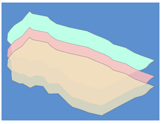
Antworten
-
They have different prime meridians
-
They have different spheroids or datums
-
They have different angular measurements
-
Plate tectonics shifted them
Frage 55
Frage
What kind of map is a land use map?
Antworten
-
General purpose map
-
Thematic map
Frage 56
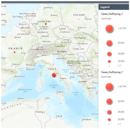
Antworten
-
Dot density map
-
Graduated circle map
-
Graduated color map
Frage 57
Frage
Which map data classification method produces a map which has an equal number of features in each class?
Antworten
-
Natural breaks
-
Quantile
-
Equal interval
-
Standard deviation
Frage 58
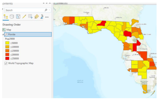
Antworten
-
Dot density map
-
Graduated (proportional) circle map
-
Graduated color map
Frage 59
Antworten
-
Natural breaks
-
Quantile
-
Equal interval
-
Standard deviation
Frage 60
Frage
An isohyet map is a
Antworten
-
thematic map
-
general purpose map
Frage 61
Frage
In a land use map, we use 1 to present urban, 2 for cropland, 3 for forest, 4 for water, ...
The land use codes 1, 2, 3, 4, ... are
Antworten
-
ratio data
-
nominal data
-
ordinal data
-
interval data
Frage 62
Frage
If we make a linear transportation network map to represent absolute traffic volume for each segment of roads, the data is
Antworten
-
nominal
-
internal
-
ratio
-
interval
Frage 63
Frage
If we make a linear transportation network map to represent absolute traffic volume for each segment of roads, we can use which of the following symbolization methods (pick three):
Antworten
-
Graduated line (width) symbols
-
Single symbol
-
Graduated colors
-
unique values
-
Proportional line width symbols
Frage 64
Frage
Diverging color scheme is best for what kind of data classification?
Antworten
-
natural break
-
quantile
-
equal interval
-
standard deviation
Frage 65
Frage
On an isohyet map, equal value lines are used to represent:
Antworten
-
atmospheric pressure
-
humidity
-
precipitation
-
temperature
-
slope
Frage 66
Frage
One inch measured on a map represents 2,000 feet on the ground, what is the scale of the map?
Antworten
-
1:1,200
-
2,000:1
-
1:2,000
-
1:24,000
-
1:2,400
-
1:12,000
Möchten Sie mit GoConqr kostenlos Ihre eigenen Quiz erstellen? eigenen Mehr erfahren.