5838084
Beschreibung
Quiz von tsampikos pompou, aktualisiert more than 1 year ago
|
|
Erstellt von tsampikos pompou
vor fast 8 Jahre
|
|
Frage 1
Frage
261 A METAR LGAL 130350Z 32OO5kt 0400N DZ 10/10 BCFG VV002 in plain language means:
Antworten
-
O Observed on the 13th day of the month at 0350Z, surface wind 320°T/05kt, minimum visibility 400 metres to the north, moderate drizzle, temperature +10°C, dewpoint + 10 °C with fog patches, vertical visibility 200ft.
-
O Reported on the 13th day of the month at 0350Z, surface wind 320°M/05kt, minimum visibility 400metres to the north, drizzle, temperature +10°C, dewpoint above 10 °Cwith fog patches, vertical visibility 200metres.
-
O Observed on the 13th day of the month and valid between 0300 and 0500Z, surface wind 320°T/05kt, minimum visibility 4000 metres to the north, drizzle temperature +10°C, dewpoint + 10 °C, becoming fog patches, vertical visibility 200ft.
-
O Reported on the 13th day of the month and valid between 0300 and 0500Z, surface wind 320°M/05kt, minimum visibility 400 metres to the north, drizzle temperature +10°C, becoming fog patches, vertical visibility 200ft
Frage 2
Frage
262 An aircraft with 1020mb set on the altimeter sub-scale departs from Dekelia-Tatoi(LGTT), which is about 800ft above mean sea level (amsl). The flight is made to the planned destination aerodrome in Sparti(LGSP), which is in an area of low pressure, but the altimeter sub-scale is not updated en route. If the QNH at aerodrome of destination, is 999mb, and the highest point on the landing area is 500ft amsl, what should the altimeter read?
Assume 1mb = 30ft.
Antworten
-
O 1130
-
O 830
-
O 130
-
O 180
Frage 3
Frage
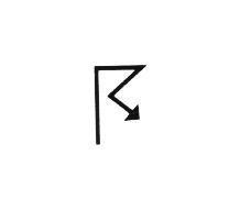
263 The symbol (Fig.31) appearing on a forecast weather chart means:
Antworten
-
O thunderstorms.
-
O severe turbulence.
-
O severe icing.
-
O severe lightning.
Frage 4
Frage
264 METAR may be defined as:
Antworten
-
O a routine weather report concerning a specific aerodrome.
-
O a routine weather report for a large area.
-
O an aerodrome forecast containing a TREND for the next two hours.
-
O meteorological, terminal area report.
Frage 5
Frage
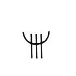
265 The symbol (Fig.32) appearing on a forecast weather chart means:
Antworten
-
O severe icing.
-
O severe turbulence.
-
O thunderstorms.
-
O rain ice decreasing then increasing.
Frage 6
Frage
266 During the evening at an inland airfield in Greece, the surface wind velocity is most likely to have …………………………………………………… from the surface wind velocity during the day. Which of the following responses correctly completes the above statement?
Antworten
-
O backed and decreased.
-
O backed and increased.
-
O veered and decreased.
-
O veered and increased.
Frage 7
Frage
267 Low level winds in the northern hemisphere that blow around a depression are drawn on surface weather charts:
Antworten
-
O in an anticlockwise direction.
-
O in a clockwise direction.
-
O across the isobars.
-
O parallel to the isobars.
Frage 8
Frage
268 Winds that blow around an anticyclone (high pressure system) at lower levels in the northern hemisphere are represented on a low level weather chart as blowing:
Antworten
-
O in a clockwise direction.
-
O parallel to the isobars.
-
O in an anticlockwise direction.
-
O across the isobars.
Frage 9
Frage
269 Which of the following correctly defines the datums for forecasting or reporting cloud bases?
Antworten
-
O METAR - agl TAF - agl Area Forecast amsl
-
O METAR - agl TAF - amsl Area Forecast amsl
-
O METAR - agl TAF - amsl Area Forecast agl
-
O METAR - amsl TAF - amsl Area Forecast amsl
Frage 10
Frage
270 The visibility group R20/0050 in a METAR means:
Antworten
-
O as measured by runway measuring equipment for runway 20, a current visibility of 50 metres
-
O for runway 20, a current visibility of 500 metres measured by runway visual range equipment.
-
O the visibility reported is 50 metres as measured by runway visual range equipment within the last 20 minutes.
-
O for runway 20, a current visibility of 500 feet measured by runway visual range measuring equipment
Frage 11
Frage
271 When a TREND is included at the end of an aviation METAR or 'Station Actual', the trend is a forecast valid for:
Antworten
-
O 2 hours after the time of observation.
-
O 2 hours after it is issued.
-
O 2 hours commencing 1 hour before the end of the forecast period.
-
O 1 hour after the time of observation.
Frage 12
Frage
272 The code: BECMG FM 1100 - RASH when used in a METAR means:
Antworten
-
O becoming from 1100 UTC slight rain showers.
-
O from 1100 UTC the cessation of rain showers.
-
O becoming fairly moderate weather from 1100 UTC.
-
O from 1100 UTC the prevailing rain showers becoming slight.
Frage 13
Frage
273 BECMG 1820 BKN030 in a TAF means:
Antworten
-
O becoming between 1800 and 2000 UTC 5 - 7 oktas, base 3000ft above aerodrome elevation
-
O gradually the wind changing to 18020kt, cloud cover changing to 5 - 7 oktas base 3000ft above ground level.
-
O becoming between 1800 and 2000 local time, 5 - 7 oktas, base 3000ft above aerodrome elevation.
-
O at 1820 UTC, cloud cover changing to 5 - 7 oktas base 3000ft above ground level.
Frage 14
Frage
274 TEMPO in an Aerodrome Forecast or TAF means:
Antworten
-
O a temporary variation to the main forecast that will last for less than an hour or, if recurring, for less than half of the period indicated.
-
O a temporary variation to the main forecast lasting less than an hour.
-
O the development of unpredictable temporary conditions that may be a hazard to aviation.
-
O a temporary variation to the main forecast lasting for less than half of the forecast period.
Frage 15
Frage
275 The correct decode for a TAF 0615 14025G40 1200 BR would be:
Antworten
-
O for the nine-hour period 0600-1500 UTC and forecasts a surface wind of 140°T at 25kt gusting to 40kt, visibility 1200 metres in mist.
-
O The forecast is for a nine hour period from 0615 UTC witha surface wind of 140°M at 25kt gusting 40kt, visibility 1200 metres in mist.
-
O for the nine-hour period 0600-1500 UTC, for runway 14 a wind of 025°T at 40kt, runway visibility 1200 metres improving to 10 kilometres or more.
-
O for the nine-hour period 0600-1500 local time, a surface wind from 140°M at 25kt, gusting 40kt, runway visibility 1200 metres in blowing rain.
Frage 16
Frage
277 A 'temperature group' of 28/24 in a METAR means that:
Antworten
-
O the temperature is 28°C and the dewpoint is 24°C.
-
O the temperature is 28°C at the time of reporting, but is expected to become 24°C by the end of the TREND period.
-
O the dewpoint is 28°C and the temperature is 24°C.
-
O the maximum forecast temperature is 28°C and the minimum forecast temperature is 24°C
Frage 17
Frage
278 The conditions experienced during flight within a cold air sector will most probably be:
Antworten
-
O good visibility below scattered to broken cumuloform cloud.
-
O poor visibility below stratiform cloud.
-
O good visibility below a high overcast.
-
O poor visibility due a low level inversion.
Frage 18
Frage
279 The atmospheric pressure at sea level in the ISA is:
Antworten
-
O 1013.25 hPa
-
O 1012.35 hPa
-
O 1025.13 hPa
-
O 1023.15 hPa
Frage 19
Frage
280 The wind that flows down the side of mountain slopes at night is called:
Antworten
-
O a Katabatic wind.
-
O an Anabatic wind.
-
O a Foehn wind.
-
O a thermal wind
Frage 20
Frage
281 There is a natural tendency for air to flow to areas of …………. pressure to areas of ………. pressure. (Fill in the missing spaces correctly)
Antworten
-
O High/Low
-
O High/High
-
O Low/High
-
O Low/Low
Frage 21
Frage
282 Land has ……………….. Specific Heat Capacity than water. (Fill in the missing space correctly.)
Antworten
-
O a lower
-
O a greater
-
O the same
-
O it depents on the temperature
Frage 22
Frage
283 The atmosphere extends:
Antworten
-
O further into space at the Equator.
-
O further into space at the Poles.
-
O equally in all directions.
-
O further into space in mid latitudesd
Frage 23
Frage
284 What is the term used to describe streamers of precipitation trailing beneath clouds, but evaporating before reaching the surface?
Antworten
-
O Virga.
-
O Foehn.
-
O Contrails.
-
O Col
Frage 24
Frage
285 A cold front moves ………… a warm front. (Fill in the missing space correctly.)
Antworten
-
O faster than
-
O slower than
-
O at the same speed as
-
O none of those
Frage 25
Frage
286 What are the characteristics of a cold airmass moving over a warmer surface?
Antworten
-
O Cumuliform clouds, turbulence, good visibility.
-
O Cumuliform clouds, turbulence, poor visibility.
-
O Stratiform clouds, smooth air, poor visibility.
-
O Stratiform clouds, turbulence, dood visibility
Möchten Sie mit GoConqr kostenlos Ihre eigenen Quiz erstellen? eigenen Mehr erfahren.