5863233
Beschreibung
Quiz von tsampikos pompou, aktualisiert more than 1 year ago
|
|
Erstellt von tsampikos pompou
vor fast 8 Jahre
|
|
Frage 1
Frage
321 Deviation is the angle between……………..
Antworten
-
O magnetic and compass north
-
O true and compass north
-
O horizontal and oblique level of compass
-
O true and magnetic north
Frage 2
Frage
325 Convert in time, the difference of longitude of 62 deg, 38 min and 45 sec.
Antworten
-
O 4h 10min 35sec
-
O 3h 23min 10sec
-
O 4h 20min 24 sec
-
O none of them
Frage 3
Frage
420 What is the angle difference, in means of longitude, for the time of 3h 30min?
Antworten
-
O 52.5°
-
O 40°
-
O 45.5°
-
O 57°
Frage 4
Frage
421 If a heading of 135° (T) is the result for track 130° and TAS 135 kts is the result of 140 kts of GS, then the wind is coming from…
Antworten
-
O 246°/13 kts
-
O 019°/12 kts
-
O 200°/13 kts
-
O 230°/12 kts
Frage 5
Frage
422 What is the distance covered in 2 and ½ minutes from an a/c, if the GS is 98 kts?
Antworten
-
O 4,10 NM
-
O 2,45 NM
-
O 3,35 NM
-
O 4,90 NM
Frage 6
Frage
423 What is the distance covered in 3 and ½ minutes from an a/c, if the GS is 165 kts?
Antworten
-
O 11,0 NM
-
O 5,8 NM
-
O 12,8 NM
-
O 13,1 NM
Frage 7
Frage
424 Given the following:
Fuel for take off: ………………………………………………….36 USG
Fuel consumption: ………………………………………….12.4 USG/h
Ground speed: ……………………………………………………………...140 kt
Airborne time after T/O: …………………………………….48 min
according to legislation, what is the distance you can fly VFR?
Antworten
-
O 182 NM
-
O 294 NM
-
O 224 NM
-
O 165 NM
Frage 8
Frage
425 During a flight from Kastoria to Alexandroupolis, you pass over Makedonia International Airport of Thessaloniki (LGTS) at 13:50 and the next reporting point, according to flight plan, is the airport of Kavala (LGKV) at 14:20.
Using the following data, estimate the IAS due to be established over Kavala on schedule.
Distance between LGTS and LGKV is 70 NM approx.
W/V is 115°/25 kt
TR is 075°
PA is 9.000 ft
OAT is -9°C
IAS should be…
Antworten
-
O 146 kt
-
O 138 kt
-
O 162 kt
-
O 168 kt
Frage 9
Frage
426 Maintaining a constant heading of 180° (M) and achieving a TAS of 130 kts, you cross R-270° of VOR at 10:37 and R-260° at 10:42. Estimate the distance and time for establishing the station.
Antworten
-
O 30 min - 65 NM
-
O 42 min - 104 NM
-
O 44 min - 96 NM
-
O 40 min - 85 NM
Frage 10
Frage
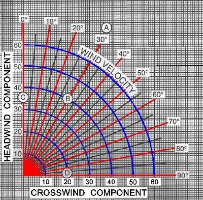
427 The maximum demonstrated cross wind component for the aircraft is 11kt.Given a 16kt wind speed, by how many degrees can a runway heading differ from the wind direction before the surface cross wind component equals 11kt? (Fig.11)
Antworten
-
O 45°
-
O 30°
-
O 60°
-
O 75°
Frage 11
Frage
429 The maximum demonstrated cross wind component for your aircraft is 15kts. Given a 19kts wind speed, by how many degrees can a runway heading differ from the wind direction before the surface cross wind component equals 15kts. (Use CRP-1 or consult Fig. 11)
Antworten
-
O 60°
-
O 20°
-
O 40°
-
O 80°
Frage 12
Frage
430 In respect of a VOR, a radial is defined as:
Antworten
-
O a magnetic bearing FROM the VOR
-
O a true bearing TO the VOR
-
O a magnetic bearing TO the VOR
-
O a true bearing FROM the VOR
Frage 13
Frage
431 When maintaining a magnetic track of 090 outbound an NDB with 6° right drift, the relative bearing indicator "RBI" will indicate:
Antworten
-
O 186° relative.
-
O 180° relative
-
O 174° relative.
-
O 090° relative.
Frage 14
Frage
432 When tracking the R-245 radial inbound to a VOR station, for the course deviation indicator (CDI) to operate in the correct sense, the omni bearing selector (OBS) should be set accordingly to:
Antworten
-
O 065.
-
O 245.
-
O 360.
-
O 180.
Frage 15
Frage
433 When maintaining a constant track to an NDB with 8° port drift, the relative bearing indicator (RBI) will indicate:
Antworten
-
O 352° relative
-
O 008° relative.
-
O 172° relative.
-
O 188° relative.
Frage 16
Frage
434 Having tuned and identified a VOR, the Omni Bearing Selector (OBS) is set to 285 and a 'FROM' or ΅ indication is produced while the Course Deviation Indicator (CDI) is centred. In relation to the VOR, in which quadrant is the aircraft receiver located?
Antworten
-
O 270° - 359°
-
O 360° - 089°
-
O 090°- 179°
-
O 180°- 269°
Frage 17
Frage
438 A Mercator chart is suitable for topographic chart. This is:
Antworten
-
O Only for equatorial region
-
O Always wrong
-
O Definitely true with no exception
-
O Only the Polar region
Frage 18
Frage
449 Magnetic track is…
Antworten
-
O the true track, corrected for variation
-
O the true track, corrected for drift
-
O the true heading, corrected for drift
-
O the true track, compensated for X-track error.
Frage 19
Frage
450 To comply with departure instructions issued by Makedonia ATC:
" Initially route to Agelo until clear of antenna masts, proceed visually to Delta not above 1500 feet and then climbing to and maintaining the flight plan altitude of 3000 feet."
What should your main altimeter subscale setting be?
Antworten
-
O Aerodrome QNH, then once clear of the TMA, set the destination regional pressure. setting.
-
O Aerodrome QNH, then once clear of the TMA, set the standard pressure setting.
-
O Aerodrome QFE, then once clear of the TMA, set the aerodrome QNH.
Frage 20
Frage
451 For a flight from LAMIA to Alexandria (LGAX) the aircraft is cleared after take off to climb from FL 40 clearing the mountains, to FL240 with a mean RAS of 200 kt and mean rate of climb of 2000 ft/min. Forecast winds and temperatures are:
FL 40 240/20 +8 ° C
FL 240 280/40 -26° C
The mean TAS for the climb is
Antworten
-
O 252 kt
-
O 265 kt
-
O 275 kt
-
O 240 kt
Frage 21
Frage
452 For a flight from LAMIA to Alexandria (LGAX) the aircraft is cleared after take off to climb from FL 40 clearing the mountains, to FL240 with a mean RAS of 200 kt and mean rate of climb of 2000 ft/min. Forecast winds and temperatures are:
FL 40 240/20 +8° C
FL 240 280/40 -26° C
The flight time for the climb is
Antworten
-
O 10 min
-
O 20 min
-
O 6 min
-
O 14 min
Frage 22
Frage
453 For a flight from LAMIA to Alexandria (LGAX) the aircraft is cleared after take off to climb from FL 40 clearing the mountains, to FL240 with a mean RAS of 200 kt and mean rate of climb of 2000 ft/min. Forecast winds and temperatures are:
FL 40 240/20 +8° C
FL 240 280/40 -26° C
What is the distance covered, upon leveling of at FL 240?
Antworten
-
O 44 NM
-
O 24 NM
-
O 54 NM
-
O 64 NM
Frage 23
Frage
454 For a flight from LAMIA to Alexandria (LGAX) the aircraft is cleared after take off to climb from FL 40 clearing the mountains, to FL240 with a mean RAS of 200 kt and mean rate of climb of 2000 ft/min. Forecast winds and temperatures are:
FL 40 240/20 +8°C
FL 240 280/40 -26° C
What is the Min Safe Altitude (MSA. for the whole route to destination?
Antworten
-
O 11.000 ft
-
O 10.000 ft
-
O 2917 m
-
O 3838 ft and 9551 ft
Frage 24
Frage
458 The letters CDI stands for
Antworten
-
O Course Deviation Indicator
-
O Centrally Dividing Indicator
-
O Compass Direction Indicator
-
O CD Category I.
Frage 25
Frage
461 You are airborne at 1208 UTC and set course overhead LAMIA-Army at 12:10 UTC. What is the expected time of arrival to Megara (LGMG) TAS=85, W/V 055°/15
Antworten
-
O 13:00
-
O 13:02
-
O 12:10
-
O 12:58
Frage 26
Frage
463 DME (Distance Measuring Equipment) uses the principles of radar to measure …………….distance.
Antworten
-
O slant
-
O vertical
-
O horizontal
Frage 27
Frage
467 The letters VOR stand for:
Antworten
-
O VHF omni-directional radio range.
-
O Variable omni-range
-
O Vissualy observed radial
-
O Variable omni-receiver.
Frage 28
Frage
468 ADF reception may be affected by:
(i) night effect
(ii) atmospheric static
(iii) terrain surrounding the station
(iv) aircraft altitude
(v) the height of the NDB station
The correct combination of the statement is:
Antworten
-
O (i),(ii) and (iii)
-
O All the mentioned.
-
O (iii),(iv) and (v)
Frage 29
Frage
469 The VOR display featured in Fig.8, gives you a X-track error of:
Antworten
-
O 4°
-
O 2°
-
O 6°
-
O 8°
Möchten Sie mit GoConqr kostenlos Ihre eigenen Quiz erstellen? eigenen Mehr erfahren.