5843939
Descripción
Test por tsampikos pompou, actualizado hace más de 1 año
|
|
Creado por tsampikos pompou
hace casi 8 años
|
|
Pregunta 1
Pregunta
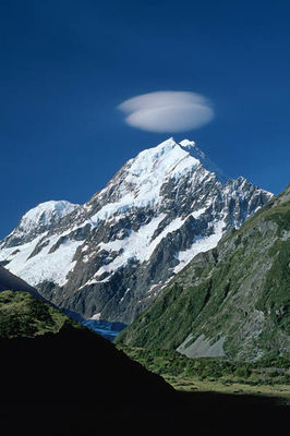
415 Υour planed route is flying with your single-engine Cessna over the valley shown in Fig. 42 and cross the mountain top. Do you think, it is best for the time being to…………………………………………………..?
Respuesta
-
O better divert, turbulent conditions will be encountered downwind, since mountain waves exist.
-
O go for it, since it is CAVOK.
-
O back-track home, since storm is being developed.
Pregunta 2
Pregunta
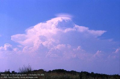
416 (Fig.43). Plan ahead. It is best to………………………………?
Respuesta
-
O divert.
-
O go for it, since fair-weather cu, nothing to worry about.
-
O continue flight, since it will dissipate soon.
-
O fly closer and inspect possibilities to penetrate.
Pregunta 3
Pregunta
417 .(Fig.53) .The symbols A and B, appearing on a forecast weather chart respectively means:
Respuesta
-
O Rain shower and snow shower.
-
O Thunderstorms and freezing rain.
-
O Snow shower and rain shower.
-
O Moderate and severe turbulence.
Pregunta 4
Pregunta
418 . (Fig.53). The symbols C and D, appearing on a forecast weather chart,
respectively means:
Respuesta
-
O Thunderstorms and freezing rain.
-
O Rain shower and snow shower.
-
O Freezing rain and thunderstorms.
-
O Nothing of them.
Pregunta 5
Pregunta
419 (Fig.53). The symbols E and F, appearing on a forecast weather chart,
respectively means:
Respuesta
-
O Tropical storm and hurricane.
-
O Rain shower and snow shower.
-
O Typhoon and tropical storm.
-
O Moderate and extreme turbulence.
Pregunta 6
Pregunta
420 . (Fig.53). The symbols G and H, appearing on a forecast weather chart,
respectively means:
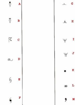
Respuesta
-
O Moderate and severe turbulence.
-
O Snow shower and rain shower.
-
O Extreme and moderate turbulence.
-
O Rain and heavy rain.
Pregunta 7
Pregunta
421 (Fig.53). The symbols I and J, appearing on a forecast weather chart,
respectively means:
Respuesta
-
O Moderate and severe icing.
-
O Rain shower and snow shower.
-
O Severe icing and moderate icing.
-
O Nothing of them.
Pregunta 8
Pregunta
422 (Fig.53). The symbols K, L and M, appearing on a forecast weather chart,
respectively means:
Respuesta
-
O Rain, snow and drizzle.
-
O Snow, rain and drizzle.
-
O Rain, fog and drizzle.
-
O Drizzle, rain and snow.
Pregunta 9
Pregunta
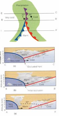
423 Complete the statement according to (Fig.50 - 33).
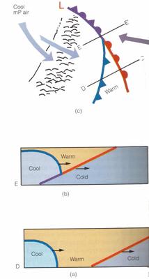
"The faster moving cold front(a) catches up to the slower-moving warm front(b) and forces it to rise off the ground.
This is the formation of……………………………………….?"
Respuesta
-
O cold front occlusion.
-
O warm front occlusion.
-
O stationary front occlusion
Pregunta 10
Pregunta
424 . Complete the statement according to (Fig.51-54)
"The faster moving cold front in (a), overtakes the slower-moning warm front in(b). The lighter air behind the cold front rises up and over the densier air ahead of the warm front(diagr.C).This is the formation of……………………………………….?"
Respuesta
-
O warm-type occluded front.
-
O cold front occlusion.
-
O stationary front occlusion.
Pregunta 11
Pregunta
425 (Fig.40). Observing the stationary cloud, well over the mountain top, you expect for:
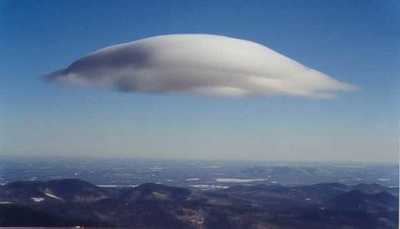
Respuesta
-
O calm conditions over that height.
-
O fast-moving air masses to create severe turbulence upwind that cloud.
-
O rain to come.
-
O still conditions.
Pregunta 12
Pregunta
426 (Fig. 41). Lendicular clouds.Choose from the following best describes.
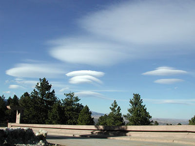
Respuesta
-
O Mountain waves (Ac)
-
O Valley clouds (Cu)
-
O High altitude clouds (Cs)
-
O Stormy weather clouds (Cb)
Pregunta 13
Pregunta
427 The Sirocco occurs:
Respuesta
-
O Ahead of a frontal depression moving east along the coast
-
O Due to intense heating causing convectional dust storms
-
O Due to the steep temperature gradient along the N. African coast
-
O Behind a frontal depression moving east along the coast
Pregunta 14
Pregunta
428 What is the approximate freezing level over Greece in July?
Respuesta
-
O 14000 feet.
-
O 12000 feet.
-
O 9000 feet.
-
O 7000 feet
Pregunta 15
Pregunta
429 Tropical maritime air originating from the Azores that affects Europe is characterised by:
Respuesta
-
O clear warm weather.
-
O moist unstable conditions leading to well developed CBs thunderstorms.
-
O good visibility at low level, with poor visibility in the middle layers.
-
O moist unstable conditions due to increased moisture content as the air tracks north east over the Atlantic Ocean.
Pregunta 16
Pregunta
430 Tropical maritime air that affects weather in Europe originates from:
Respuesta
-
O the Azores.
-
O the Indian Ocean
-
O the Mediterranean.
-
O the north Atlantic.
Pregunta 17
Pregunta
431 In Europe, away from exposed coasts, airmass thunderstorms are most likely to occur in:
Respuesta
-
O the afternoon in summer.
-
O warm spells in winter.
-
O the evening, with Westerly winds in summer.
-
O the afternoon in winter
Pregunta 18
Pregunta
432 What is the approximate freezing level in Scandinavia in January?
Respuesta
-
O 0 feet
-
O 2000 feet.
-
O 3500 feet.
-
O 1000 feet.
Pregunta 19
Pregunta
433 Polar continental air in winter is likely to bring what type of weather to Europe?
Respuesta
-
O Cold weather, clear skies, frost and coastal showers.
-
O Good weather, or stratus, sea fog and drizzle.
-
O Convective cloud, showers and thunderstorms
-
O Snow showers or hail.
Pregunta 20
Pregunta
434 Tropical maritime air brings to Europe:
Respuesta
-
O stratus, drizzle and poor visibility.
-
O stratus, stratocumulus, rain and poor visibility.
-
O cumulus, stratocumulus, showers and good visibility
-
O convective clouds and thunderstorms.
Pregunta 21
Pregunta
435 In summer in Europe, tropical continental air is most likely to produce:
Respuesta
-
O hot and hazy conditions.
-
O widespread air mass thunderstorms.
-
O high altitude cloud, i.e. cirrus.
-
O hot and wet conditions.
Pregunta 22
Pregunta
436 The upper winds in Europe are predominately:
Respuesta
-
O westerlies both in summer and winter
-
O westerlies in summer and easterlies in winter
-
O easterlies in summer and westerlies in winter
-
O easterlies both in summer and winter
Pregunta 23
Pregunta
438 Syberian anticyclone is :
Respuesta
-
O A long lasting phenomenon over C.Eastern Europe, triggering radically the character of greek winter.
-
O A typical weather of central Syberia.
-
O Local wind of Archangellsk, in Northern Rusia.
-
O Last face of winter.
Pregunta 24
Pregunta
439 Every physical process of weather is accompanied by or is the result of
Respuesta
-
O a heat exchange.
-
O instability .
-
O a pressure differential.
-
O vapour condensation
Pregunta 25
Pregunta
440 In the Northern Hemisphere, the wind is deflected to the
Respuesta
-
O right by Coriolis force.
-
O right by surface friction.
-
O left by pressure gradient force.
-
O left by centrifugal force
¿Quieres crear tus propios Tests gratis con GoConqr? Más información.