9053075

Pregunta 1
Pregunta
What is a biome?
Respuesta
-
A specific geographic zone that only exists in one place and has unique species inhabiting it.
-
A pacific geographic area distinguished by its unique flauna.
-
A specific geographic area distinguished by its climate and the species inhabiting it.
-
A specific pacific zone with some mascarpone, on a scone and a weird tone on the telephone
Pregunta 2
Pregunta
Climate Patterns:
Polar: Every month in a polar climate has an average temperature of [blank_start]less than 10[blank_end] °C.
Sub-arctic: In winter, temperatures can drop to [blank_start]−40[blank_end] °C and in summer, the temperature may exceed [blank_start]30[blank_end] °C.
Continental: Continental climates often have a significant annual variation in temperature (hot summers and cold winters). Continental climates have a coldest month [blank_start]below[blank_end] -3 °C depending on and four months [blank_start]>[blank_end]10 °C.
Mountain: A climate which causes trees to fail to grow due to [blank_start]cold[blank_end] and where no month has a mean temperature higher than 10 °C.
Temperate: In geography, temperate or [blank_start]tepid[blank_end] latitudes of Earth lie between the tropics and the polar regions. The temperatures in these regions are generally relatively moderate, rather than extremely hot or cold, and the changes between summer and winter are also usually [blank_start]moderate[blank_end].
Steppe: A steppe is a dry, grassy [blank_start]plain[blank_end]. Steppes occur in temperate climates, which lie between the tropics and polar regions. They receive 25 to 50 centimetres of rain each year.
Equatorial: Regions with this climate experience high temperatures all year round. The average monthly temperatures are about [blank_start]26 – 28[blank_end] degrees Celsius. The annual temperature range is very small. Humidity is usually very high.
Savanna: The Savanna biome has a wet/dry climate.The savanna climate has a temperature range of 20° - 30° C. In a Savanna the temperature [blank_start]does not[blank_end] change a lot. When it does, it's very gradual and not drastic.
Desert: Is a climate that does not meet the criteria to be classified as a polar climate, and in which precipitation is too low to sustain most vegetation. Desert climates experience from 25 to 200 mm per year of [blank_start]precipitation[blank_end]. There are usually two or three variations of a desert climate: a hot desert climate, a cold desert climate and, sometimes, a mild desert climate.
Respuesta
-
less than 10
-
more than 50
-
less than -10
-
greater than 31
-
50
-
40
-
−40
-
-60
-
-10 but < 40
-
>20 but <10
-
40
-
30
-
below
-
above
-
not even close to
-
greater than
-
<
-
>
-
cold
-
rolled oats
-
jolts
-
mould
-
insipid
-
tepid
-
rapid
-
telid
-
high
-
considerate
-
moderate
-
crate
-
plain
-
pain
-
plane
-
kain
-
20 - 24
-
26 – 28
-
30 - 43
-
10 - 5
-
does not
-
do
-
does
-
do not
-
precipitation
-
persimmons
-
percipitation
-
pertipitation
Pregunta 3
Pregunta
Lines of latitude run [blank_start]east–west as circles parallel[blank_end] to the equator.
Lines of longitude [blank_start]circle the earth from pole to pole[blank_end] at varying angles.
Image:
Sungrid 3 (image/gif)
Respuesta
-
east–west as circles parallel
-
up down as circles perpendicular
-
circle the earth from pole to pole
-
circle the earth parallel to the equator
Pregunta 4
Respuesta
-
moths
-
days
-
weeks
-
months
-
carto-
-
line
-
blind
-
sine
-
bar
-
beer
-
column
-
carto-
Pregunta 5
Respuesta
-
train
-
rain
-
clear skies
-
isometric
-
isobar
-
air pressure
-
air size
Pregunta 6
Pregunta
Air flows in an anticlockwise direction of the low-pressure system in the Northern Hemisphere, and in a clockwise direction in the Southern Hemisphere.
Respuesta
- True
- False
Pregunta 7
Respuesta
-
Warm front
-
Cold front
-
Warm front
-
Cold front
Pregunta 8
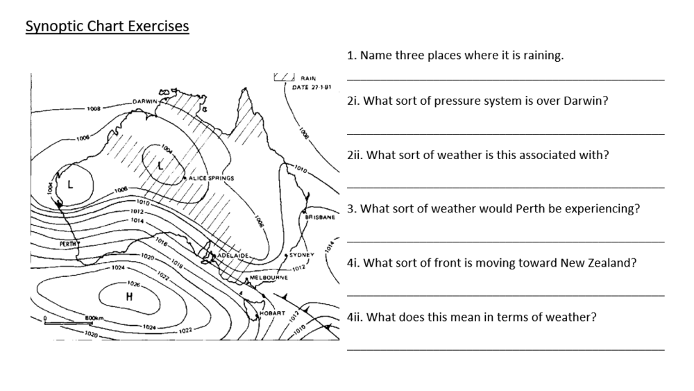
Respuesta
-
Hobart, Brisbane, Newcastle
-
Adelaide, Hobart, Darwin
-
Alice Springs, Adelaide, Darwin
-
Darwin, Perth, Sydney
-
Low pressure
-
High pressure
-
Hot, clear skies
-
Cloudy, unstable and rainy
-
Cold, clear skies
-
Rainy but humid
-
Edible weather
-
Rain and thunderstorms
-
Low winds but rain
-
High winds but dry weather
-
Cold front
-
Warm front
-
Back to front
-
Rain and clouds
-
Pain and clouds
-
Hot dry weather
-
Shrouds
Pregunta 9
Pregunta
Why are rainforests important? (you can tick more than 1)
Respuesta
-
Oxygen production
-
They looks cools
-
Cool wallpapers
-
Carbon capture
-
Plants from which medicines can be sourced
-
Carbon production
-
Vast biodiversity
-
We need a place to pollute. duh
Pregunta 10
Pregunta
What is is the wind direction at Hobart and where does it originate from?
Image:
Unfilled Chart (image/png)
Respuesta
-
North west, North west
-
North west, south east
-
South east, north west
-
320 degrees, south east
-
320 degrees, north west
Pregunta 11
Pregunta
Looking at the top of the high pressure zone above New Zealand which direction is the wind moving in and what is it called.
Image:
How To Read 2 (image/gif)
Respuesta
-
West, easterly
-
East, westerly
-
270 degrees, westerly
-
90 degrees, easterly
¿Quieres crear tus propios Tests gratis con GoConqr? Más información.