13710137
Description
Flashcards by Davina Ngenegbo, updated more than 1 year ago
|
|
Created by Davina Ngenegbo
almost 6 years ago
|
|
| Question | Answer |
| What are Cumulus clouds? | Clouds that often have a flat base, and are described as "fluffy" and "large" in appearance. They can form low in the sky. 3,300 feet. |
| What is Physical Geography? | The study of processes and patterns in the natural environment, such as volcanoes and erosion. |
| What is Human Geography? | The study of processes and patterns in the built environment, such as buildings and docks. |
| What do the abbreviations of: RB A SO EA W DEP RI DES SE T L FL RA VE VO and C mean? | 1. River Basin 2. Atmosphere 3. Soil 4. Earthquake 5. Weathering 6. Deposition 7. Rivers 8. Deserts 9. Sea 10. Thunderstorms 11. Landforms 12. Floods 13. Rain 14. Vegetation 15. Volcanoes 16. Climate |
| What is Environmental Geography? | How we, humans, affect and change our surroundings; how we pollute the air and water, destroy plants, kill animals, and how we can change this to look after our environment. |
| What are latitude and longitude lines? | Latitude: Lines Around the earth. Longitude: Lines Over the top of the earth These lines, measured in degrees and the compass points, show where countries and places are around the world. The latitude lines go from East to West and the longitude lines go from North to South. |
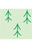
| What map feature is this? | Coniferous trees. |
| What does the key term 'relief' mean? | It's used to describe the shape of land. |
| What are spot heights? | They give the exact height of a point on a map. They are shown as a black dot which has a number next to it (to represent the height of the land). |
| What are contour lines? | Lines that join places that have the same height. They are usually coloured brown and have the height marked on them. |
| What is layer colouring? | Layer colouring (or layer shading), show large sections of different heights which are represented by different bands of colour - there always needs to be a key to show each section. |
| What is a sketch map? | A very undetailed drawing or picture of another area. Not a lot of buildings will have been drawn on and not to scale. |
| What is the capital of Australia? | Canberra |
| What is Great Britain made up of? | Scotland, England and Wales. |
| What is the UK made up of? | Scotland, England, Wales and Northern Ireland (REMEMBER: The Republic of Ireland is not part of GB or The UK - It's its own thing!). |
| Is Norway part of the EU (NOT EUROPE)? | No. |
| What is the weather? | The day to day condition of the atmosphere. |
| Why have sales for diesel cars slumped? | They're bad for the environment - they release harmful gases. |
| What is the ozone layer meant for? | It's meant to protect us from radiation and keep us from the cold. |
| In winter, why are the clocks moved forward? | It gets dark much quicker. |
| What is a season? | A period of the year defined by district climate. |
| What is meteorology? | The study of weather; to measure and record the weather frequently. |
| What is precipitation? | Water falling from the sky (this includes hail, sleet, snow, etc). |
| How is cloud cover measured? | In oktas. |
| Convectional Rainfall | The usual way rain forms: Sun heating the ground, water evaporating, droplets forming together to create a cloud. Then, once the droplets get too big and reach their dew point, they turn back into a liquid and it rains. |
| What are Stratus clouds? | Large blankets of cloud that can cause overcasts; low-level clouds with a uniform base. 6,000 feet. |
| What are Cirrus clouds? | Thin, wispy clouds that form high in the sky. It's so cold where they are, they're made out of ice crystals. 20,000 feet. |
| Frontal Rainfall | Warm and cold air travelling from different parts of the world and then eventually clashing; The dense, warm air is forced to rise. It eventually cools, creates a cloud, and then it starts to rain. |
| Relief Rainfall | Warm, moist air rises over relief features, like mountains and hills; the air cools and condenses, forming clouds; and as it rains, the air descends, becoming warmer and drier. |
| How many m tall is Mount Everest? | 8848m tall |
| What is the average lifespan of a hurricane? | 7-14 days |
| What map feature is this? | Bridge |
Want to create your own Flashcards for free with GoConqr? Learn more.