378129
Description
Mind Map by georgia.somerville, updated more than 1 year ago
|
|
Created by georgia.somerville
over 10 years ago
|
|
Restless Earth
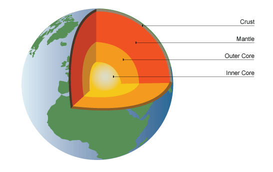
- Two types of crust
- Continental crust - makes
up most of the land area of
the Earth. Dominated by
rocks below the surface
such as granite.
- Between 25 and 80km thick
- Between 25 and 80km thick
- Oceanic crust - much thinner, made up of rocks such as basalt.
- Between 6 and 8km thick
- Between 6 and 8km thick
- Continental crust - makes
up most of the land area of
the Earth. Dominated by
rocks below the surface
such as granite.
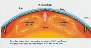
- How the earth's tectonic plates move
- Convection Currents - High temps in the core caused by
gradual radioactive decay create rising limbs of material in
the mantle
- Cool and spread out before sinking again like a lava lamp.
Some move in sheets, creating movements in the crust
above, which is pulled apart to form a new crust.
- Other places it rises as columns, creating hotspots.
- Other places it rises as columns, creating hotspots.
- Cool and spread out before sinking again like a lava lamp.
Some move in sheets, creating movements in the crust
above, which is pulled apart to form a new crust.
- Convection Currents - High temps in the core caused by
gradual radioactive decay create rising limbs of material in
the mantle
- Plate boundaries
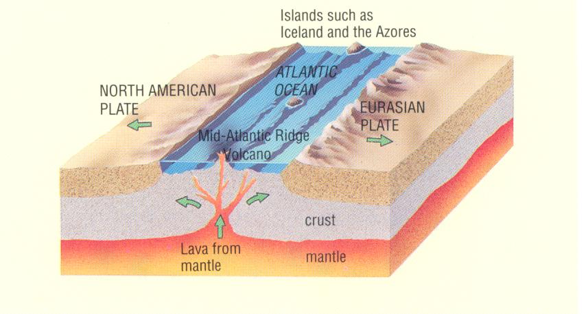
- Constructive margins
- Formed by magma splitting
up continental crust and
forming new oceans.
- E.g. The Eurasian
plate and North
American plate.
- Formed by magma splitting
up continental crust and
forming new oceans.
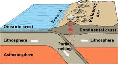
- Destructive margins
- Oceanic plates collide with Continental plates
- When this occurs, the denser basaltic oceanic plate sinks beneath the continental plate
- This process is known as subduction and
creates a very deep ocean trench near the line of
contact between the oceanic and continental
plates
- Increase pressure and temperature
- Lightweight materials melt and rise to the surface to form volcanoes
- As a result- long chains of volcanoes, known as volcanic arcs are
located above subducted plates
- Collision of the plates also lifts and buckles the continental plate, creating fold
mountains; for example the Andes.
- Collision of the plates also lifts and buckles the continental plate, creating fold
mountains; for example the Andes.
- As a result- long chains of volcanoes, known as volcanic arcs are
located above subducted plates
- Lightweight materials melt and rise to the surface to form volcanoes
- Increase pressure and temperature
- This process is known as subduction and
creates a very deep ocean trench near the line of
contact between the oceanic and continental
plates
- When this occurs, the denser basaltic oceanic plate sinks beneath the continental plate
- Oceanic plates collide with Continental plates
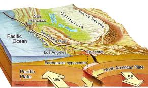
- Conservative margins
- Where plates slide past each other or move in
the same direction but at different speeds
- No crust is formed or destroyed, no volcanoes form
- Strain builds up along the junction, with
sudden lurches along the fault
- Earthquakes are frequent and often large
- Earthquakes are frequent and often large
- Strain builds up along the junction, with
sudden lurches along the fault
- No crust is formed or destroyed, no volcanoes form
- Where plates slide past each other or move in
the same direction but at different speeds
- Constructive margins
- Different hazards and their causes
- Volcanic eruptions generate earthquakes,
but earthquakes also occur on conservative
margins.
- Two main types of Volcanoes
- Composite/strato
- Steep sided, small area. Alternate layers of lava and ash
- Magma/lava type- viscous/sticky and flows slowly.
- Infrequent and sometimes unpredictable.
Happens due to pressure building up over time
- Examples - Mt. Pinatubo (Philippines) and Mt. Sakurajima (Japan)
- Examples - Mt. Pinatubo (Philippines) and Mt. Sakurajima (Japan)
- Infrequent and sometimes unpredictable.
Happens due to pressure building up over time
- Magma/lava type- viscous/sticky and flows slowly.
- Steep sided, small area. Alternate layers of lava and ash
- Shield
- Gentle Slopes, Almost all lava
- Fluid- flows very very quickly
- Very frequent and generally gentle erruptions
- Mauna Loa (Hawaii, USA) and Mt. Nyiragongo (DRC)
- Mauna Loa (Hawaii, USA) and Mt. Nyiragongo (DRC)
- Very frequent and generally gentle erruptions
- Fluid- flows very very quickly
- Gentle Slopes, Almost all lava
- Composite/strato
- Earthquakes are more dangerous
because you can't predict them
- Both can cause a Tsunami as
a Secondary Hazard. Travel
across oceans at speeds up to
900 km/h and be 20-30m high
- Volcanic eruptions generate earthquakes,
but earthquakes also occur on conservative
margins.
- Impact of Earthquakes
- Factors that
control severity;
-Magnitude -The
depth -Distance
from epicentre
-Time of day
-Level of
preparedness
-Quality of
emergency
services
- Epicenter- point on the
earths surface vertically
above the focus of an
earthquake
- Epicenter- point on the
earths surface vertically
above the focus of an
earthquake
- Primary impacts- Immediate effect (Deaths, shaking and property destruction)
- Secondary impacts- Property
and people of an event after it's
finished (Fires, lack of shelter)
- Port-au-Prince, Haiti
- Magnitude 7.0 , Depth 13km , 316,000 deaths
and 30,000 injuried, £8.5 billion lost (Primary)
7000 people killed, 1 million people
homeless(Secondary)
- Magnitude 7.0 , Depth 13km , 316,000 deaths
and 30,000 injuried, £8.5 billion lost (Primary)
7000 people killed, 1 million people
homeless(Secondary)
- Factors that
control severity;
-Magnitude -The
depth -Distance
from epicentre
-Time of day
-Level of
preparedness
-Quality of
emergency
services
- Living with Volcanoes
- Active, dormant or extinct.
- Dormant - A volcano which hasn't erupted in a
long time but is till capable of doing it.
- Dormant - A volcano which hasn't erupted in a
long time but is till capable of doing it.
- Active, dormant or extinct.
- Prediction, warning and evacuation
- Can normally be predicted (aswell
as tsunamis) if the right equipment is
in place
- Gas emissions - Earth tremors
and 'bulging' of a volcano's
flanks can be measured and
used to predict eruptions
- Tsunami sirens
- Gas emissions - Earth tremors
and 'bulging' of a volcano's
flanks can be measured and
used to predict eruptions
- Mitigation - Action of reducing the
severity of something
- Developed wold- making new buildings better.
- Foundations deep but allow movement, shock
absorbers built, cross bracing to prevent floors
collapsing
- Developing world- Reduce weight of
roofs, lightweight hollow bricks used,
strengthen wall corners with wire mesh
and cement
- Developing world- Reduce weight of
roofs, lightweight hollow bricks used,
strengthen wall corners with wire mesh
and cement
- Can normally be predicted (aswell
as tsunamis) if the right equipment is
in place
- Response and relief in Haiti
- Event
- Strongest earthquake in Haiti since 1770, 7.0
magnitude, epicentre was 10 miles west of
Port-au-Prince and its 2 million people living
there. Aftershocks ranging in magnitude from
4.2 to 5.9
- Strongest earthquake in Haiti since 1770, 7.0
magnitude, epicentre was 10 miles west of
Port-au-Prince and its 2 million people living
there. Aftershocks ranging in magnitude from
4.2 to 5.9
- Response
- 3 million people in need of emergency aid and the red cross dispatched a
relief team. World vision provided food to .2 million people, emergency shelters
for 41,000 families with 16 millions litres of clean water, installed 300 showers
and 240 toilets. Inter-American Development bank gave $200,000 grant for
emergency aid and Obama promised $100,000 million in aid to Haiti
- Event
Media attachments
Want to create your own Mind Maps for free with GoConqr? Learn more.