Description

|
|
Created by tessa.piccolo7
over 8 years ago
|
|
Page 1
Geograpy Exam Notes
Regions Region Definition- An area with unifying characteristics. These can be identification characteristics such as weather, climate, and cultures. They can also be identified by how you personally perceive them. There are many different types of regions. In particular there are landform regions. Landforms are natural features on the earth's surface so therefore landform regions are different areas with defining physical/environmental features. In Canada there are seven landform regions. They are the following:Innuitian Mountains-In Canada's far north -2,500 meters in height -Composed mostly of sedimentary rock-Younger than the Appalachian Mountains therefore erosion has not worn them down as much-Older than the Rockies -Barren (have no vegetation) -Trees can not grow due to the cold and short summers Hudson Bay- Arctic Lowlands-Found on the shore of Hudson Bay and James Bay -Flat low area covered by swampy forest-Covered by water at one point in history that compacted rock, silt, and sand to create sedimentary rock -Not an ideal area for farming (rounds remain frozen for most of the year) -Made up of a series of islands-Contains lignite (a poor quality of coal), oil and natural gas deposits Great Lakes St. Lawrence Lowlands -Where the Niagara Region is Located -Small but largely populated -Made up of the Great Lakes and St.Lawrence river, separated by a thin wedge of Canadian Shield -Made up of many escarpments the largest being Niagara Falls itself -Well suited for agriculture because of fertile soil and warm climate -Most densely populated regionWestern Cordillera-Found on the western side of Canada -Consists of a range of mountains-Difficult for travel routes because of mountains are in thawed -Vancouver and Victoria are the largest cities Great tourist area because of beautiful scenery/ mountains Interior Planes (Prairies)-Stretch from the Arctic Ocean to the Gulf of Mexico -Mostly flat land (Alberta, Saskatchewan) caused by erosion -Oil and gas is found here -Potash is mined and used for fertilizer, coal is also mined-Known as "Canada's Breadbasket" because so much wheat is grown -Soil is fertile because of ancient seas during the paleozoic era -Coal and oil was made in the carboniferous eraCanadian Shield-The geologic foundation of Canada -More than half of Canada is covered by the shield -Some of the Canadian shield is made up of ancient mountains that have been eroded -Vast deposits of lead, gold, copper, nickel, zinc, and other important metals -Mining is in abundance Appalachian Mountains -Stretch from Georgia to Newfoundland-Oldest highland region in North America -Formed 300 million years ago -Rich in deposits of non-metallic mineral such as coal and metallic minerals such as iron and zinc
Different types of Geography Geography: The Study of the earth and human interactions with it Physical Geography: The study of the natural world including all aspects of the atmosphere, land, and water bodies Human Geography: The study of Human population, their activities and behaviors along with their relationship with and impact on the physical landscape Environmental Geography: The study of the interaction between humans and the physical world Economic Geography: The study of how people earn a living and the distribution of economic activities on the earth's surface (e.g.. shopping malls; types of jobs in a certain area)
Cosmic Egg- Big Bang Theory The big bang theory as it is most commonly referred to is the theory created by ________ which addresses the beginning and creation of our universe. The theory originated in 1927. This theory states that all the mass of our universe was once packed together as something called "the cosmic egg". Many people believe that the cosmic egg exploded but many scientists now believe that the cosmic egg expanded, not exploded. All of the mass was then flying around at high speeds. This mass eventually started gathering which is what we know today as planets. Because the cosmic egg expanded it is still expanding today which means that although we know space is extremely large, it is actually growing daily. That is why space is called endless. Where it is expanding, it is extremely hot but it eventually cools which is why most of space that we know has very cold temperatures. Convection CurrentsConvection currents are the movement beneath the earth's surface which cause the tectonic plates to ship. These movements are made by molten lava slowly moving in a circular motion under the earth's crust. Convection currents are believed to be the cause behind Pangea and the continental drift. Plate TectonicsA theory explaining the structure of the earth's crust.
The Four Geologic Eras The world's history is divided into four separate time periods. In each of these "eras" significant events have occurred that have helped shaped the world we know today. Each of the eras have different defining characteristics and have left a separate mark on our earth.Precambrian EraThe precambrian era was the the first and longest era in the world's history. If we were to measure the four eras on our arm the pre-cambrain era would take up from the beginning of our shoulder down to around the beginning of our wrist. This period began around 4500 million years ago and ended around 600 million years ago. This period can be further broken down into the early middle precambrian era (4500 million years ago to 1500 million years ago) and the the late precambrian era(1500 million years ago to 600 million years ago). The only life during this period was small single-celled organisms such as algae. This is because the only fossils found have been those of single-celled organisms and they would be the only type of specinim to be able to survive the harsh conditions of the earth's surface at that time. During the early to mid precambrian era the Canadian Shield was formed by hardened molten lava from volcanoes. During this time metallic minerals such as gold, sliver, bronze, nickel, and copper were developed and in the late precambrian era, a new outer edge of the Canadian Shield was formed by old sediment and new volcanic activity. Palaeozoic EraThe Paleozoic era began 600 million years ago. Referring back to your arm it would be from your ______ to your ______. A unique characteristic of this era is that during this time, most of Pangea was covered by shallow seas. Because of this the life that existed at this time was mainly a form of fish called crinoids (coral) and bottom feeders. Many fossils have been found of specimens dating back to this era. It was also during this time that coal was created by layers of ancient sea and plant life slowly compressing under layers of other life and layers of sediment. This is also known as the "Carboniferous Period". The Appalachian Mountains were also formed during this time by convection currents dragging continental plates together forcing land up. Mesozoic EraThe Mesozoic era began around 225 million years ago. The life during this time was mainly reptiles which came from the seas and onto the land forming a new animal life known as the age of the dinosaurs. Large deposits of substances such as coal, oil, and gas are found is Western Canada because of the remains of the former life being compressed. Two different landforms were created during this era. These were the Arctic mountain ranges (Innuition Mountains in Canada's north) and the Western Cordillera (Rocky Mountains). The Interior Plains (The Prairies) were also formed during this period. These were created by the shallow inland seas receding which is why today the Prairies have such fertile farm land. Cainozoic EraThe Cenozoic era started 65 million years ago and is the age of the mammals meaning that we are part of this era. During this short period, there have been four major Ice Ages. The Western Cordillera grew larger because of volcanoes adding more mountain ranges onto the coastline of BC. In both BC and YT there has been Igneous and Metamorphic rock found. The Appalachian mountains and the Canadian Shield continue to erode during this period.
Resources There are many different types of resources. There are both renewable and non-renewable resources (to be explained later) Examples of resources are coal, oil, lumber, natural gas, fishing, farming etc. These resources are used for anything from energy to transportation. The Rock Cycle Igneous Rock: rock formed by the cooling of magma or lava. Magma that erupts out of a volcano is called lava. When lava cools and hardens on the earth's surface it is called volcanic igneous rock. If magma cools and hardens under the earth's surface it is called plutonic igneous rock (extrusive and intrusive). Examples: Granite, obsidian, pumice, and basalt. Characteristics: Gas bubbles can possibly look like swiss cheese (basalt). Glassy surface, shiny and smooth (obsidian). Metamorphic Rock: just as cookie dough changes as it is baked, rock changes as it's heated, squeezed or both. Rocks deep within the earth are put through intense heat and pressure. In time, these forces change sedimentary or igneous rock into a type of rock that is known as metamorphic rock. Examples: Marble, slate, gneiss, quartzite, and schist.Characteristics: Ribbonlike layers, straight or wavy stripes (gneiss and marble). Sedimentary Rock: wind, water, chemical reactions and ice cause erosion, breaking off pieces of rock and carrying them from one place to another. Gradually these pieces along with sand, pebbles, shells and plant mutterer deposited in layers on the bottoms of lakes, seas, and oceans. Over a long period of time, and under immense pressure caused from the weight of the sediment, these particles are compressed and formed into sedimentary rock. Sedimentary rock is the most common type of rock found the the earth's surface. Examples: Shale, dolomite, sandstone, limestone, and conglomerateCharacteristics: Sand or pebbles. Individual stones and pebbles (conglomerate). Fossils, imprints of ancient life (limestone). Tectonic Plates/ Plate TectonicsThe earth's crust is a thin cool layer of magma on the outside of the earth like an egg shell. Under the earth's crust there is molten rock (mantle). Scientists believe that the crust is made of tectonic plates. Tectonic plates are pieces of molten metal floating on the earth's mantel. These plates are constantly moving because of the slow circular movement of the molten lava under the crust. These plates are what are held responsible for a variety of past and present events and natural disasters. This is because if the plates have sudden movements it will amplify until the earth's surface causing the land to shake and can cause a massive amount of damage. The Continental Drift The continental drift is a theory that the tectonic plates are constantly moving causing the land/continents to slowly move as well. This was the cause of what scientists call Pangea. Pangea was a "supercontinent" that existed around 180-200 million years ago. Pangea means "all lands" or "all earth". This theory was created by Alfred Wegener in the early-mid 1900s. There were many pieces of evidence that have been found that support this theory. These include the matching nightgowns of Africa and South America, identical fossils and rock formations found on continents separated by oceans that the fossilized animals did not have the ability to cross. There were also fossilized remains of tropical plants and animals found in Antarctica where they would never had been able to survive.
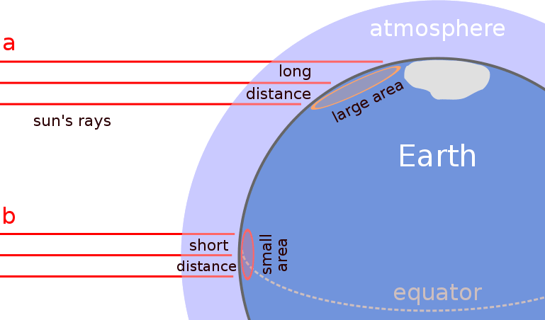
Climate Climate: Climate is defined by long-term average weather patterns. Canada in particular the climate is very varied because of it's large size, different elevations, coastal ranges, wind and pressure systems. The closer to the border you are, the hotter it is going to be. This is why places such as Brazil, Florida, Australia, and India. There are six different factors. These are referred to the acronym LOWER Near Water. Latitude Ocean Currents Winds and Air Masses Elevation Relief Near Water Latitude- Latitude affects climate because of a few key factors. These factors are mainly in lower Canada because it is farther south and therefore closer to the border making the climate warmer. Also when the sun's energy is concentrated in a small area (equator) the climate will be warmer but when the suns energy is projected at an angle over a large area (North) the climate will be cooler because the energy is being spread out over a larger area making it more dispersed. Places located at high latitudes (far from the equator) receive less sunlight than places of low latitudes (close to the equator)
Canada's Natural Renewable and Non-renewable ResourcesCanada is considered a country rich with natural resources. Resources that are common in Canada are lumber, farming, fishing, coal, oil, gold (in the north), and other metallic minerals. These resources are a mix of renewable and non-renewable resources. By definition, a renewable resource is a resource that can be replenished in a reasonable amount of time without a large amount of human interference. Examples of renewable resources are lumber, solar power, and wind power (although wind and solar power are considered to be more renewable energy sources than resources). Non-renewable resources are resources that either are not able to replace itself or would take an extremely long time to replenish. Examples of non-renewable resources are coal, oil, and metallic minerals because once they are removed from the the ground, it would take thousands or maybe millions of years and various geological processes to occur before it would be possible for them to be replenished. This has posed numerous problems in the past and present because of the worry of us becoming much too dependent on these resources such as oil so that hen they run out (which in time they will) we will not have prepared with an alternative energy source because how our society is based today, we would run into many extreme problems if our oil and gas resources ran out. This leads into the next topic of: Alternative Energy Sources There are many alternative energy sources that we could use instead of oil. Like all resources, they all have different advantages and disadvantages and all have a different impact of our environment and economy. The first alternative energy source is perhaps the most well known, solar energy. Solar energy the the energy of harvesting the energy from the sun by using photovoltaic cells (solar panels) which then coverts it using a generator into power and electric which can be used in everything from your house to your car. Some pros of solar energy are that they are a clean energy source. It is also an unlimited resource because if we run out of sun we have a lot bigger problems than finding energy. Also access power can be stored in batteries for night time, or sold back to hydro companies. A big con of solar energy is the cost. It is commonly known that solar panels are extremely expensive as are the generators and the storage batteries. It is clear that if his becomes our primary energy source, there will have to be a dramatic drop in the cost in order for them to be affordable for everyone. The next alternative energy option in wind power. Wind power is exactly what it sounds like, using the power from wind and converting it into electricity. This is done by using large wind turbines which are mainly in rural areas but as they have become increasingly popular, have spread into some urban areas.
Want to create your own Notes for free with GoConqr? Learn more.