Description
Page 1
1.1 What are the characteristics of a desert environment that make it extreme?
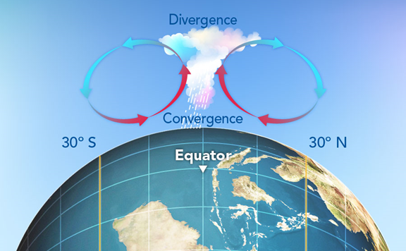
RainfallDeserts are arid environments. They're classed as arid if they receive less than 250mm annually.The aridity depends on rainfall and evapotranspiration.Deserts locationsTropical atmospheric circulation (Hadley cell) 30 degrees north and south of the equator - global atmospheric circulation - hot air rises at the equator. moisture condense and falls as rain which leaves the air dry. The dry air descends 30 degrees north and south of the equator meaning very little precipitation e.g. Sahara desertContinentality - once the wind and clouds reach central areas it carries little/no moisture from seas/oceans e.g. TurkestanRain shadow effect - at high altitude mountains the ability for clouds to hold moisture is reduced, therefore cannot get over/past the mountain range e.g. Atacama because of the Andes mountain range.Cold ocean currents - the colder the ocean the less evaporation, therefore less precipitation can occur e.g. Namibia desert because of cold current in the South East Atlantic.ClimateMean annual temperatures are high - 20 to 30 degrees celsius.Large seasonal variations.Daily variations - 50C in the day and below 0C at night - because of the lack of clouds that cannot trap heat.VegetationBiomass is low because of a lack of water.Variations and spread out e.g. little by a sand dune, but a number of cacti, grasses and shrubs in others.Plants have specialised to love in this extreme environment e.g. Cactus... Waxy coats reduce transpiration and protects them from herbivores Large stems store water Small spiny leaves reduce transpiration and protect them from herbivores Long shallow roots absorb water over large areas, whilst taproots reach deeper water SoilEither stoney or sandy.Soils are dry because of low rainfall and high temperatures.Not very fertile because they don't contain much organic matter.
Page 2
1.2 How is human activity causing pressures on the desert environment?
DesertificationDesertification is the degradation of semi-arid land by human activities and changes in climate. It leaves land unproductive. Africa and Asia are the worst affected areas. 46% of Africa is at risk of desertification (25% is at a high or very high risk).How does human activity cause desertification?1. Enhanced climate change/global warming Lower rainfall Climate change is likely to reduce rainfall in sub-tropical regions (where most semi-arid environments are). If theres less rain then surface water and groundwater will be reduced as its evaporated and not replenished. Amount of water for vegetation is reduced which causes death to vegetation. Roots of plants and trees bind the soil together. Fewer plants and trees mean fewer roots, leading to soil erosion Higher temperatures Global surface temperatures has risen by 0.6C over the last 100 years and is predicted to increase. As temperatures increase the rate of evapotranspiration increase. This will dry out the soils and lower surface water levels, leading to soil erosion. 2. Direct human activityOvergrazing - reduces vegetation, leads to soil erosion (lack of plant roots). Trampling by large numbers of animals compresses and breaks down the structure of the soil, which makes soil erosion more likely.Over cultivation - reduces soil productivity as the over-exploitation of the soil leaves it without enough nutrients to support plants. Without plants and their roots the soil is easily eroded.Deforestation - removing trees and their roots means soil is vulnerable to erosion. Deforestation occurs for farm land and wood for fuel and building materials.irrigation - irrigation techniques erode soil directly - large amounts of water in a short period washes topsoil away.Population growth - increases pressure on land as more food in demand, which leads to further overgrazing, cultivation, deforestation and irrigation.Impact of desertificationImpacts the land, ecosystem and the population. Less plants mean less animal life which means biodiversity decreases. Agricultural productivity decreases meaning they migrate. The migration pattern will increase desertification as the host areas population increases therefore factors above occur. If they do not migrate it is likely to face famine.Case study - SahelSahel region runs across east to west Africa. Separates the hyper-arid Sahara from the wetter and more fertile savanna further south. The Sahel runs through 10 countries which are some of the poorest countries in the world (HIPCs). It receives 200mm-600mm of rainfall a year (large variation). How does human activity affect the Sahel?Climate change 1968-1997 rainfall in the Sahel decreased between 29% and 49%. Increased amount of droughts. Average temperature has increased over the last 100 years causing impacts stated above. Agriculture 1968-1998 population increased from 274 million to 628 million. Higher food demand. Areas of good agricultural land has reduced - more land used for game parks and tourists. Less land available means pressure on land - overuse on the land. Restriction of nomadic tribes because of strict border controls means overuse of land and lifestyle changes as they 'settle down'. Political instability and war has caused migration patterns, higher population = overuse of land. E.g. war between Ethiopia and Eritrea caused migrants to go to Sudan (30,000). Deforestation 82% of homes and industry are fuelled by wood. High demand for wood means jobs to collect wood. Rate of deforestation increases. This has caused environmental, social and economic impacts:Erosion of topsoil has reduced the area of productive agricultural land in the Sahel. Niger 2500km2 of agricultural land is lost to deforestation. As agriculture land decreases the amount of for decreases, causes loss of livelihoods and famine. 2 million people have migrated from Mali and Burkina Faso because of desertification. Fertile soils become scarce which increases tensions between farmers and nomadic herders, which has led to violence. Animal migration has also increased which has increased rodents, destroyed crops and new diseases in other areas.Also mention similar occurrences in Spain e,g, overuse of farming in Southern Spain because of high demand in exports (links to water sustainability). Tourism increased water use e.g. water parks and golf courses - affects farmers. Blackmarket for water. Water has become salinised, little use and damages soil. MiningOil - Saudi Arabia (Arabian desert).+ Positive multiplier effect - economically, but wealth is only concentrated? So isn't touched among majority of population.- Desert environment suffered, it has to be removed to extract oil.- Destroys animal and plant habitat- Oil leaks affect ecosystem and water supply.- Pollutes the desert environment.- Needs for infrastructure (roads and electricity) means more destruction of the desert environment.Uranium - Niger (Sahara desert)Found underground for nuclear power in Niger (former French colony) and is 4th poorest countries in the world. French company Areva found Uranium (1970s) as Niger don't have the capital to search and extract it themselves (TNCs are moor powerful than countries :S), means that the company have exploited them.Unlike Saudi Arabia with the positive multiplier effect, it cannot be felt across the society and economy in Niger, as a small amount are spent on standards of living increasing and profits are returned to France. - radioactive waste contaminates water and surrounding area.- Independent investigation has never been carried out by companies - Greenpeace did and radioactivity levels were 100x times higher than recommended amount. Arrive do not care. - Exposure to radioactivity causes major health concerns such as birth defects, cancer and leukaemia.- But company states they are monitored.- local hospital owned by Areva, but lack equipment and expertise to properly carry out diagnosis', with people experience unrecognised diseases. - TNC has failed economic promises to Niger.- 10 years time the economic activity will stop as it would have run out of uranium.Comparison between Niger (LEDC) and Australia mining (MEDC). Australia benefits both environment, society and economy. Environment because of deep shaft mining mining, better working and living standards - based communities and economically valuable.Urbanisation in the desert environmentDubaiHad the ability to grow rapidly because it is oil rich in the 1990s. Economic development has diversified and has expanded into the tourism industry. Has broken previous models of city growth, evidential through no river nearby and their desalination program. Dubai has developed due to the high economic potential, however it has depleted natural resources - for example, oil extraction and water desalination (which has raised salt concentration in the sea) and the use of grey water. Environmentally it destroys the local environment and the expansion has made things worse, for example, airports and linking infrastructure and dune bugging. There has been a culture clash between tourists ('western world') and Arabs - due to religion. UAE is a secular society based upon religion, whereas the tourists can be seen as 'lenient' to religious beliefs.Las VegasLas Vegas has faced similar development in the desert environment. However, they do follow the desalination program, as there is a river (Colorado) located nearby which stores water through the Hoover dam. The Hoover dam has affected the desert environment as it has ruined the river regime. . It has led to water deprivation further down the river and flooded land behind it. Las Vegas has developed economically because of the potential it holds, rapid development occurred in the early 21st century and has focused on the gambling and party industry. Before Dubai it was a unique and iconic label to urbanisation in the desert industry and still is for gambling.
Page 3
1.3 What are the strategies that can be used to manage human activity in deserts?
See mind map for more information
Strategies to manage desertificationMaking agriculture sustainable by reducing overgrazing, over cultivation and improving the fertility of the soil. Leaving areas of land fallow (not cultivated) - allows soil to recover from grazing. Adopting nomadic farming - nomadic herders constantly move animals on, prevents areas being overgrazed. Rotating crops - different crops need different nutrients, rotating crops stops the same nutrients being depleted year after year. Improves soil fertility. Adding compost improves soil fertility. Make water use more sustainable by reducing water usage. (LINK METHODS FROM G4) Growing crops that need little water e.g. olives, millets. Using drip irrigation - adds small volumes of water over a period of time. Effective because 1. Reduces waste water. 2. Prevents soil eroding. Increase or maintain the level of vegetation to reduce erosion. Planting trees - acts as windbreaks, protects soil from wind erosion. Using alternative energy sources - solar cookers reduce deforestation (wood for fuel). External aid is needed to trigger these changes.The strategies above costs money, for equipment or for education programs to train local people. This money often comes from external aid.Sustainable strategies address the causes of desertification.Strategies above are successful as they prevent desertification and if implemented can be carried out in local communities without the need of external aid. Once they have been educated and given the possibility, external help is no longer needed. Effective as it teaches the need for sustainable approaches against desertification and also shows an alternative.Examples: Mali - Jatropha curvas is grown in hedges around food crops. It's able to grow in poor quality soil and isn't ate by animals. Its roots help bind the soil together and protects soil from wind and water erosion. Oil is produced from the plant which can be sold, creating an income. Reduced poverty (LINK WITH DEVELOPMENT and erosion in areas. Plant can also be burnt for deforestation, therefore, reduces deforestation. Burkina Faso - contour bunding/magic stones is a low cost technique. Stones are placed around agricultural land to keep rainfall. Maximises water use and prevents soil erosion. Increased yields by 40%, but can only be used with specific stones. Niger - NGOs has reduced soil erosion by providing free seeds that are suitable for arid conditions (G4 SUSTAINABILITY). These plants grow extensive roots to keep the soil together, which also absorb water from deep underground = less vulnerable to drought. Successful for reducing soil erosion, however, encourages agricultural production in high risk areas of desertification. Eritrea - efficient version of a stove (mogogo). Needs 50% less wood, therefore reducing deforestation. Chad - manure rather than wood for fuel to reduce deforestation. Chad - NGOs launched schemes to reduce soil erosion by educating villagers about importance of maintaining plenty of vegetation. Scheme has promoted co-operation between neighbouring villages to avoid over-exploitation, encourage co-operation and reduce tensions e.g. tribal tensions. External aid has had negative impacts. 1968-73 drought thousands of wells were built. Farmers increased the amount of livestock, but the land couldn't cope with overgrazing. Large areas therefore became decertified.
Page 4
1.4 What are the characteristics of the artic and alpine tundra that make it extreme?
Factors that make the tundra environment cold:HIGH LATITUDE - receive less solar radiation.HIGH ALTITUDE - air temperature decreases with increasing altitude. Less of the Sun's energy reflected back from the Earth is trapped at higher altitudes, making it cooler. Lower air pressures higher up also mean temperature falls.Both the alpine and arctic tundra make up 16% of the earth's surface area. Alpine environmentCold areas of land at an altitude above the treeline. The treeline is the limit of the area that trees can grow - above the treeline its too cold. Found on mountain ranges e.g. Himalayas, Andes and the Alps. Growing season lasts 180 days with summer temperatures between -12C to 10C. The biodiversity attracts tourists during summer months.Arctic environmentArctic tundra can be classed by being above 66 degrees north, or by the 10C July isotherm (areas north of this line have average temperatures below 10C in July). The Arctic environment is made up of sea ice that shrinks in the summer and refreezes in the winter and northern land areas of Asia, North America and Europe. Average temperature ranges between -5C and -10C. Long dark winter months temperatures fall to -20C. Growing season ranges from 50-60 days a year. Average annual precipitation is 150mm to 250mm (including snow).In the summer months it is dominated by high pressure and subsiding air which leads to low mean precipitation. Daylight hours are long however as the sun's angle is so low the temperature rarely rises above 10C. During the summer months the ground is permanently frozen, except the top 50cm.Animal lifeWinter months large mammals, reindeer and caribou, migrate south. Smaller mammals, hares, burrow under the snow to keep themselves warm. Most animals have compact bodies and short limbs to retain heat. Also have thick fur. Caribou and reindeers have large hooves to move easily on snow and boggy surfaces. When the surface meals in the summer months insects emerge which provide food for migrating birds. Plant lifeUsually small to cope with severe winds. Many have hollow stems so the temperature inside the stem is warmer. Majority of plant is below the ground to ensure survival. Some have fine hairs to protect them from wind and low temperatures. Many plants are fast growers, however, they don't flower yearly, but only when they have enough nutrients. Generally have dark leaves to absorb more radiation.Soil qualityThe arctic tundra soil is easily eroded and characterised by the presence of permafrost - limits biological activity (root growing, animal burrowing and decomposition of organic matter). Alpine tundras well drained due to the absence of the permafrost layer. Soil is of poor quality. 9 months of the year it is frozen which prevents development and decomposition. There is also little to decompose as there is minimal plant growth anyway. When the soil does defrost (summer months) it becomes boggy and acidic, known as peat. Mosses and lichen survive in that environment.In the alpine tundra the conditions are still harsh, however the soil has better drainage and supports a greater variety of plants.
Page 5
1.5 How is human activity causing pressures on the arctic and alpine tundra environment?
Examples: Alaska, Greenland, Scandinavia, Russia.Why has human activity occurred?Overall - economic potential - generating wealthValuable resources:Oil rich tundra - Alaska, USA and Russia.Countries management in extracting oil varies and therefore has different rates of effecting the tundra environment. Also, causes social and economic impacts.Mineral and gold rich tundra - Canada and Alaska.Gold rush occurs which led to the establishment of mining towns.(Alpine) HEP potentialTourismAttractive which is a modern and unique form of tourism. Arctic tundra includes polar bear watching and cruises.Alpine tundra includes winter sport.Oil extractionCountries should consider both the economic impact and the environmental impact.Negative - RussiaSome countries 'ignorant' to the tundras ecology and therefore destroys the tundra. Russia had previously dumped radioactive military vehicles which has contaminated the tundra environment. This has led to mutations in humans (high cancer rates) and animals and affected the food chain. Constructed multiple pipelines from the frozen Siberia to southern Russian and European cities. There has been a high amount of oil leaks with a lack of monitoring. As Russia hasn't focused on the environment it has led to vast economic growth and a militant superpower. European nations are seen as dependent on Russia's oil supply. The extraction can be seen as morally and ethically wrong, due to the devastation on the tundra, however it has enabled economic growth.Positive - Alaska, RussiaHas considered the tundra environment, but perhaps restrained economic growth. The pipeline is known as the the Trans Alaskan Pipeline (TAP). Cost $8 billion across 800 miles. US government has firmly rejected expansion plans - private oil firms offering government money. The restriction of the pipelines questions the full potential of the TAPs economic growth. However, it does deliver 20% of the US domestic oil production.Constructed eco-friendly. Constructed over 10 feet and some underground to avoid subsidence through hot oil and allow animals to migrate. Plants were even replanted. Accidents have occurred, at least they're being monitored. In 1989 a spill on Alaskan coast = 40 million litres of oil. Killed more than 250,00 birds and fish. Between 1977-94 there were on average between 30-40 spills a year, sometimes caused intentionally and sometimes forest fires. Numbers have now decreased and $60 million is spent annually for spill prevention and response.Hydro Electric Power (HEP)Specifically in the alpine tundra by the construction of dams in valleys. +RenewableCheaper than non-renewables and some renewables-EyesoreDam blocks migration patterns for fish and prevents them reaching spawning grounds, decreasing fish population.Heat up water endangering species used to colder temperatures.Holds back river flow and affects river regime. Floods area behind the dam and further down there can be water deprivation.MiningCaused ground and surface water contamination through chemicals for mining or materials being mined. For example, Lead-Zinc mine in Maarmorlik, Greenland which closed in 1990 but lead and zinc are still released, polluting nearby fjords. Solid waste and wastewater has to be disposed. Some mines in Russia and Alaska were no constructed to deal with large quantities of waste = waste released into atmosphereTourism (Alpine)Zermatt, SwitzerlandPreviously winter sports were associated with middle/upper class, but now available to all society. Creates a wide range of impacts as it isn't just the physical activity, but the ambience and services around the industry. Cannot be accessed without roads, airport or housing employees. Creates growth in employment, development and local economy.Overuse on ski runs and high demands has resulted in rapid unsustainable growth. Obstacles and vegetation is removed = affecting the food chain. Avalanches has increased due to strain on snow, damaging bars, hotels and ski resorts = halt in local economy. Summer months. The altered landscape means snow melt in Apr/May flows down quickly = more surface runoff = flooding. Slopes become scarred as vegetation and mud gets washed away. Seasonal sport = seasonal employment and economic income. Tourism (Arctic)Father Christmas in Lapland, Finland.Polar bear tourism in AlaskaPositive multiplier economically as it leads to rise in consumerism, creating jobs. Polar bear tourism educates tourists about the ecosystem, but has become an issue to the ecosystem. Polar bears become reliant on humans feeding them, receive an unnatural diet and disrupts breeding times. Danger risk - student killed due to a polar bear.Lapland . Seasonal as its only available 3/12 months a year.Whale watching. Seasonal as whales migrate. Settlements capable of holding high number of people, but vacant half the year.Seasonal employees have to return to original jobs.Impact on nativesInuitsLive in northern Canada, Greenland and Russia. Follow a traditional lifestyle of fishing and hunting for food and clothes. Increased human activity from 'westerners' has caused the tribes to decrease. In Canada during 1800s and 1990s 90% died because of diseases westerners brought. Increase of whaling, sealing and fishing has reduced numbers for Inuits = straining natural resources. Led to migration of Inuits away from the tundra.Human activity elsewhere (but affects the tundra environment)Global atmospheric circulation patterns cause air in industrial areas (mid-latitude e.g. Europe, northern USA) to become pollutant and transported to the tundra area. Impurities are then deposited.ConclusionPositive economically, mixture of social impacts but no positive impacts on ecology. But sustainable growth and awareness ensures minimal damage is done or adapted with the environment, rather than against it.
Page 6
1.6 What are the strategies that can be used to manage human activity in arctic and alpine tundra?
Why is there a high demand?High economical demand, but it has to be managed effectively to protect the fragile tundra environment.Indirect methods - Climate ChangeUK was the first ever country to implement a Climate Change Act. But, one country isn't enough!Global policies established by nations, not a nation, to reduce the enhanced greenhouse effect. E.g. Kyoto Protocol and France Summit 2015. These policies ensure sustainable development like clean energy and transport initiatives.However, these have to work with united nations globally, if a number of countries do not follow it will be less effective. E.g. USA never signed which accounts for 25% of world emissions. Also, the targets have to be reached and if they're not fines should be implemented. Should be regulation on TNC activity, for example the European Union regulates companies activity to make sure they're working with environmental caution.National level - National Parks and action on TNCsNational Park statu reduces economic development on specific areas and magnifies the need for environmental protection. This has meant several areas in Alaska are now protected. However, National Park status can be degraded if an economic offer is profitable. Yet National Park status has meant the refusal of oil lines in Alaska. National Park status can only be implemented by governments and a distinct geographical boundary. TNCs do not work around boundaries and enhance development on non-national park status. Governments may be welcoming with company development (as economic demand is partially needed) but maintained on eco-friendly approach. To ensure this happens short-term contracts can be awarded. This can be TNCs which extract raw materials, offer tourist facilities and services which ensures development works around the tundra environment. If the company they would become replaced by a new company. Fining has been previous policy, however it is difficult to measure and quite often don't dent TNCs profits. For example, oil spillage in Port Valdez, the oil company would've faced a fine, but wouldn't impact the companies high profits.Deal: National Park - AlaskaEstablished in 1917, expanded in 1980. Cars and private vehicles are banned. Visitors must access the area on park buses on approved routes. The National Park has been monitored and categorised areas. Vulnerable areas don't even have roads. Churchill Wildlife Management area.Description: Churchill is the largest wildlife management area, almost 850,000 hectares, and one of the most important in the province. It protects the polar bear’s summer resting areas and maternity denning grounds, where the white bears are born. Churchill is also the northernmost WMA, accessible by railway, air or cruise ship. For many, a trip to Churchill is an opportunity of a lifetime and you will be richly rewarded with the wildlife you see.Social approaches/awarenessGroups can educate societies to develop in sustainable ways. Areas of the Alpine tundra have been forced, preventing future ski lanes. There has been U-turns on economic development by afforestation, which has helped balance flooding and avalanche effects.
Page 7
G3B - Deprivation
'Deprivation levels in Newport get better from the inner city areas to the suburbs'Newport - easy to complete fieldwork.2 wards in the inner city studied and 2 wards in the outer city studied. It would be impossible to analyse every ward in the city. Secondary data: Geography textbooks magazines (journals) and factsheets that the school and library had Geography AS/A2 textbooks that shown urban structure models like the Burgess and Hoyt models. Shaw and McKay (1942) states that higher crime is near the inner city and gets less as one moves to the suburbs. These models are out of date, generalised and based on US cities. Ignores urban structure of large council estates built post-world war 2 on rural urban fringe. Internet searches mainly shown US results. Textbooks and AS knowledge shows segregation e.g. student districts near the city (cheap housing, bus and railway stations, entertainment districts), ethnic minorities and immigrants may live near each other for religious, cultural, language and safety reasons. 'Hotspots' for crime. Newport 2011 census data shown unemployment rates, housing types (terraced, semi-detached, detached, flat), tenure (ownership e.g. rented from council, housing association, owner occupied) of housing, qualification levels, long term illness and job type. Gwent Police website has mapped areas of crime e.g. anti-social behaviour, vehicle crime, burglary etc. Accurate? yes its from Gwent Police, however crime does go unreported. Statistics on GCSE and A Level results A*-C and % of free school meal. However, all schools in Newport are state schools meaning quality of education is generally the same. Census data shown most deprived areas were around the city centre (exception of Allt-yr-yn) and large council estates on the rural-urban fringe of Newport. Least deprived areas are in suburbs (Langston, Carlen, Graig, Llanwern and Marshfield). There was a link between deprivation and crime emerged.The census dat was mapped using a choropleth system showing 20 wards in Newport. I also used this for the Gwent Police records for anti-social behaviour. This enabled me to notice 'hotspots'.All of the inner city wards have high deprivation levels, including crime, apart from Allt-yr-yn. The worst of the inner city wards was Pill which had the highest unemployment figures, long-term illness, no or one car, 3rd highest no qualifications, household with children but no earners.In the suburbs most of the wards had low levels of deprivation. Lowest being langstone. However there were wards that defeated the hypothesis, such as Bettws, Tredegar Park and Ringland which had high levels of deprivation.Primary data (on the field trip): Evidence of vandalism, run down buildings and public ways, groups of youths and quality of the environment. Annotated photographs shown factors above. Questionnaire for members of the public which lived in those areas - general and personal questions on lifestyle, there was also a pilot questionnaire. There was a sample size of 20 people for each ward, which was done systematically (10 men to 10 women). There was some bias - often denial about deprivation in that area. Most deprived areas had low cost housing usually terraced or 3 storey flats. Housing and scenery was poorly maintained. In Pill few houses had greenery, in Bettws there was more greenery, but were generally overgrown. In Pill few houses had driveways or cars and the cars which were there was generally low quality and ageing. In all deprived areas there was services such as shopping parades, which were mainly vacant. High levels of graffiti and ethnic minorities concentrated (segregation).Shopping parades 'In many cases, parades will offer a critical level of service to disadvantaged communities, particularly those with lower mobility levels and constrained disposable income. Traders tend to be more responsive to local need and often have close links with their customer base... Face to face contact and personalised interaction are identified as essential characteristics of neighbourhood provision. They form an integral element of local ‘place’, often referred to as the ‘glue’ that binds communities together. Affluent areas (Allt-yr-yn and Langstone) shown no evidence of vandalism. Houses were larger often detached or semi-detached with large gardens which were maintains with driveways and cars. Houses in Langstone modern 'Since the 1990s, many have moved to the area because of its appeal as being rural, but also minutes away from the M4 motorway. This population influx in the '90s resulted in the construction of a large housing development at the bottom of Cat's Ash Road, together with developments of housing estates, big and small, along Tregarn Road and Magor Road.'Supporting the point later on that they have not lived there all their life. Very few people were seen there during the day as it is likely they are working.Questionnaire results stated that due to their income they lived in those areas. Many said they were unemployed or on minimum wage in deprived. In affluent areas owners generally had a mortgage or owned their property. Health was generally poorer in deprived areas, with few saying they were depressed, stressed or obese. In Langstone poor health was the result of old age. Those in deprived areas had no GCSEs/O levels, compared to those in affluent areas which achieved A levels and gone to university. The crimes in the affluent areas was generally vandalism on cars, because criminals targeted the wealthy areas.Hypothesis'Deprivation levels in Newport get better from the inner city areas to the city'.There are anomalies. It depends which direction outwards of the centre you take. If it was Pill - Langstone it would be correct. However it it was Allt-yr-yn - Bettws it would be wrong. The hypothesis is true theoretically, however, factors such as construction of council estates create anomalies and previous factory owners in the inner city. EvaluationThere was limited time carrying out the project. The Census Data was 6 years out of date, but accurate at the time. Assess sources of data. Perhaps compare to Cardiff to see if hypothesis is correct. Re-urbanisation projects fight the hypothesis e.g. Cardiff St. Davids and Newport Friars Walk.
Want to create your own Notes for free with GoConqr? Learn more.