Description
Page 1
Two types of crust Continental crust - makes up most of the land area of the Earth. Dominated by rocks below the surface such as granite. Oceanic crust - much thinner, made up of rocks such as basalt. Between 25 and 80km thick Between 6 and 8km thick
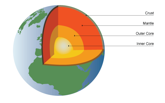
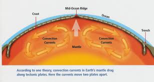
How the earth's tectonic plates move Convection Currents - High temps in the core caused by gradual radioactive decay create rising limbs of material in the mantle Cool and spread out before sinking again like a lava lamp. Some move in sheets, creating movements in the crust above, which is pulled apart to form a new crust. Other places it rises as columns, creating hotspots.
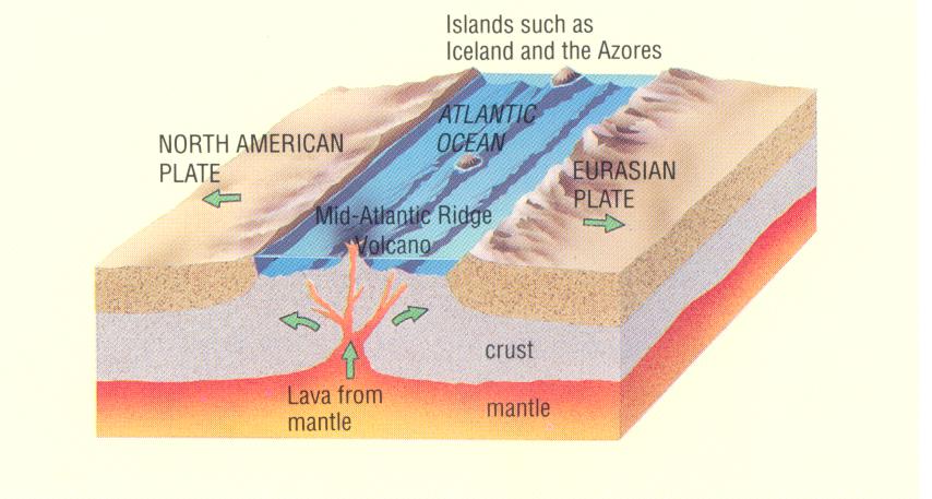
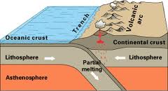
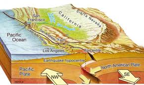
Plate boundaries Constructive margins Destructive margins Conservative margins Formed by magma splitting up continental crust and forming new oceans. E.g. The Eurasian plate and North American plate. Oceanic plates collide with Continental plates When this occurs, the denser basaltic oceanic plate sinks beneath the continental plate This process is known as subduction and creates a very deep ocean trench near the line of contact between the oceanic and continental plates Increase pressure and temperature Lightweight materials melt and rise to the surface to form volcanoes As a result- long chains of volcanoes, known as volcanic arcs are located above subducted plates Collision of the plates also lifts and buckles the continental plate, creating fold mountains; for example the Andes. Where plates slide past each other or move in the same direction but at different speeds No crust is formed or destroyed, no volcanoes form Strain builds up along the junction, with sudden lurches along the fault Earthquakes are frequent and often large
Different hazards and their causes Volcanic eruptions generate earthquakes, but earthquakes also occur on conservative margins. Two main types of Volcanoes Earthquakes are more dangerous because you can't predict them Both can cause a Tsunami as a Secondary Hazard. Travel across oceans at speeds up to 900 km/h and be 20-30m high Composite/strato Shield Steep sided, small area. Alternate layers of lava and ash Magma/lava type- viscous/sticky and flows slowly. Infrequent and sometimes unpredictable. Happens due to pressure building up over time Examples - Mt. Pinatubo (Philippines) and Mt. Sakurajima (Japan) Gentle Slopes, Almost all lava Fluid- flows very very quickly Very frequent and generally gentle erruptions Mauna Loa (Hawaii, USA) and Mt. Nyiragongo (DRC)
Impact of Earthquakes Factors that control severity; -Magnitude -The depth -Distance from epicentre -Time of day -Level of preparedness -Quality of emergency services Primary impacts- Immediate effect (Deaths, shaking and property destruction) Secondary impacts- Property and people of an event after it's finished (Fires, lack of shelter) Port-au-Prince, Haiti Epicenter- point on the earths surface vertically above the focus of an earthquake Magnitude 7.0 , Depth 13km , 316,000 deaths and 30,000 injuried, £8.5 billion lost (Primary) 7000 people killed, 1 million people homeless(Secondary)
Living with Volcanoes Active, dormant or extinct. Dormant - A volcano which hasn't erupted in a long time but is till capable of doing it.
Prediction, warning and evacuation Can normally be predicted (aswell as tsunamis) if the right equipment is in place Mitigation - Action of reducing the severity of something Developed wold- making new buildings better. - Foundations deep but allow movement, shock absorbers built, cross bracing to prevent floors collapsing Gas emissions - Earth tremors and 'bulging' of a volcano's flanks can be measured and used to predict eruptions Tsunami sirens Developing world- Reduce weight of roofs, lightweight hollow bricks used, strengthen wall corners with wire mesh and cement
Response and relief in Haiti Event Response Strongest earthquake in Haiti since 1770, 7.0 magnitude, epicentre was 10 miles west of Port-au-Prince and its 2 million people living there. Aftershocks ranging in magnitude from 4.2 to 5.9 3 million people in need of emergency aid and the red cross dispatched a relief team. World vision provided food to .2 million people, emergency shelters for 41,000 families with 16 millions litres of clean water, installed 300 showers and 240 toilets. Inter-American Development bank gave $200,000 grant for emergency aid and Obama promised $100,000 million in aid to Haiti
Restless Earth
Want to create your own Notes for free with GoConqr? Learn more.