
Quiz
Unit 2 - Physical Connections
Fragen in diesem Quiz (50)
1The red dots on the map represent:
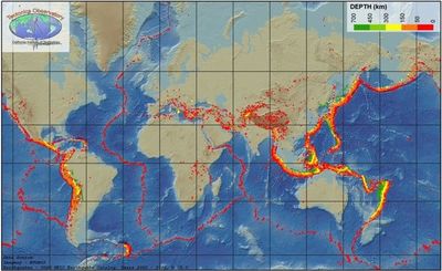
- ALocations of earthquakes and volcanoes.
- BInternational ocean boundaries.
- CPlaces where migratory birds rest.
- DBiodiversity Hot Spots.
2Earthquakes that occur under the water are called:
- Atsunami
- Bunder water earthquakes
- Ckawasaki
- Ddisasters
3About how many Earthquakes can be felt every year?
- A30,000
- B3,000
- C300,000
- D300
4Who proposed the Continental Drift Theory?
- AAlfred Wegener
- BTuzo Wilson
- CSir Samford Flemming
- DAlbert Einstein
5Alfred Wegener had four proofs for his Continental Drift Theory. Which of the following is not one of his proofs?
- AThat the tectonic plates moved due to convection currents in the Earth.
- BThe jigsaw fit between South America and Africa
- CFossils of the same plants and animals on both continents
- DThere are mountains of similar age and structure in North America and Europe.
- EIce covered places that are now warm. They must have been somewhere else when it happened.
6What year did Alfred Wegener propose his Continental Drift Theory?
- A1915
- B1815
- C1715
- D1851
7In the 1960s Canadian J. Tuzo Wilson proposed which theory?
- APlate Tectonics
- BContinental Drift
- CPangaea Theory
- DRock Cycle
8Why was Wegener's Continental Drift Theory not accepted?
- ANo one knew of any force that was powerful enough to move continents.
- BThere was no evidence for it.
- CPangaea did not exist.
- DNo-one knew about it.
9Which statement about Plate Tectonics is incorrect?
- AEarth’s outer shell is made up of about 20 plates.
- BMost plates contain a continent and an ocean.
- CThe plates float on a layer of hot rock hundreds of kilometers below the surface.
- DThe plates each move about a kilometer a year.
- AEarth’s outer shell is made up of about 20 plates.
10What causes the tectonic plates to move?
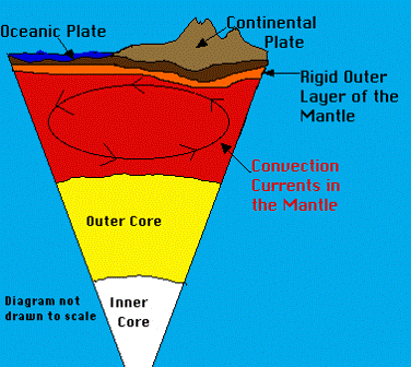
- AConvection currents.
- BOceanic Plate
- CContinental Plate
- DThe continents float in the ocean.
11What causes land to be built up?
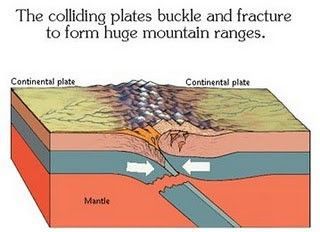
- APlate tectonics
- BWind
- CErosion
- DWater
12What causes elevated areas on Earth to be worn down?
- AErosion
- BPlate Tectonics
- CVolcanoes
- DEarthquakes
13What are the two main causes of erosion?
- Awind and water
- Bvolcanoes and earthquakes
- Cwind and volcanoes
- Dwater and earthquakes
14Place the main Geologic Eras in the correct order - from oldest to newest.
- APrecambrian, Paleozoic, Mesozoic, Cenozoic
- BCenozoic, Mesozoic, Paleozoic, Precambrian
- CPrecambrian, Cenozoic, Paleozoic, Mesozoic
- DCenozoic, Paleozoic, Precambrian, Mesozoic
15Which of the following is NOT a type of rock?
- AIgneous
- BMetamorphic
- CSedimentary
- DVolcanic
16Igneous rock is formed when:
- Amagma cools
- Bsediment is compacted and cemented
- Cheat and pressure is applied
- Dweathering and erosion
17Metamorphic rock is formed when
- Arock is exposed to heat and pressure
- Bmagma cools
- Cweathering and erosion
- Dcompaction and cementation
18Sedimentary Rock is formed when
- AMagma cools
- BRock is exposed to heat and pressure
- CSediments experience compaction and cementation
- DWind and erosion
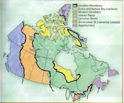
19What landform is Oakville located in?
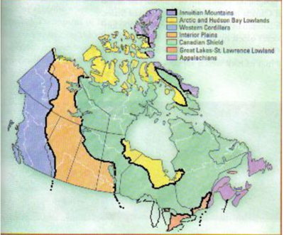
- AInnuitian Mountains
- BWestern Cordillera
- CAppalachians
- DGreat-Lakes-St. Lawrence Lowlands
20What landform is Temagami, and most of Ontario and Quebec found in?
- AWestern Cordillera
- BInterior Plains
- CCanadian Shield
- DGreat-Lakes-St. Lawrence Lowlands
21What landform is British Columbia found in?
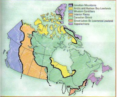
- AArctic and Hudson Bay Lowlands
- BCanadian Shield
- CAppalachians
- DWestern Cordillera
22Which landform would be best for Farming?
- AInnuitian Mountains
- BWestern Cordillera
- CCanadian Shield
- DGreat-Lakes-St. Lawrence Lowlands
23Which landform would be best for fishing?
- AAppalachians
- BMetallic Minerals Canadian Shield
- CArctic and Hudson Bay Lowlands
- DInterior Plains
24Which landform would be best for Mining Metallic Minerals?
- AInnuitian Mountains
- BCanadian Shield
- CInterior Plains
- DArctic and Hudson Bay Lowlands
25During the Last Ice Age, Canada was almost completely covered by glaciers.
- ARichtig
- BFalsch
26Which of the following statements is NOT true regarding glacier formation?
- AForm when the snow that falls in the winter does not completely melt in the summer.
- BOver thousands of years, the snow becomes very thick.
- CThe weight of the snow turns the bottom layers to ice.
- DThe cooling of magma makes glaciers larger.
- AForm when the snow that falls in the winter does not completely melt in the summer.
27How do continental glaciers move?
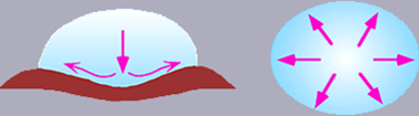
- AAs the snow accumulates, the glaciers move slowly across the landscape.
- BAs the snow melts every year, they move forward.
- CThey only move when it is snowing.
- DContinental glaciers are too large to move.
- AAs the snow accumulates, the glaciers move slowly across the landscape.
28How do Alpine glaciers move?
- AMove down valleys from high elevations to low elevations under the force of gravity.
- BThey move up mountains due to the large amount of ice and snow.
- CThey do not move because they are too heavy.
- DThey flatten all mountains, then move like continental glaciers.
- AMove down valleys from high elevations to low elevations under the force of gravity.
29Which of the following statements about how Alpine glaciers shape the land is incorrect?
- ASharpen the upper portions of the mountains and give them a rugged appearance.
- BWhen they move down valleys, they scrape away the valley walls to produce broad U-shaped valleys
- CThey can change the rivers running in the area.
- DThey flatten all mountains to make the land flat when they melt.
- ASharpen the upper portions of the mountains and give them a rugged appearance.
30How do Continental Glaciers shape the land?
- AGive the landscape a smoother appearance by eroding higher points on the land and filling in lower areas with the eroded material.
- BSharpen the upper portions of the mountains and give them a rugged appearance.
- CWhen they move down valleys, they scrape away the valley walls to produce broad U-shaped valleys.
- DThey do not shape the land.
- AGive the landscape a smoother appearance by eroding higher points on the land and filling in lower areas with the eroded material.
31Which of the following is NOT a factor that affects climate?
- ALatitude
- BOcean Currents
- CWind and Air Masses
- DTemperature
32Which Climate Factor is illustrated in the picture?
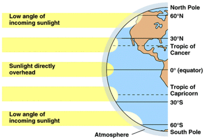
- ALatitude
- BWind and Air Masses
- CNear Water
- DRelief
33Which of the following statements about Ocean Currents is INCORRECT?
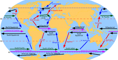
- AOcean currents carry warm or cool temperatures to different places.
- BCurrents originating near the equator are warm, near the poles, cool.
- CThe air above the current takes the temperature of the water.
- DThe air above the ocean is usually very dry.
- AOcean currents carry warm or cool temperatures to different places.
34Which of the following statements about Wind and Air Masses is INCORRECT?
- AAir takes the climatic conditions where it was formed.
- BMoist over water, dry over land.
- CCool in cold areas, warm in warm areas.
- DAir and Wind Masses stay stationary all of the time.
- AAir takes the climatic conditions where it was formed.
35What causes Prevailing Winds?
- AThe rotation of the Earth, along with high and low pressure areas cause air to move in well-established patterns
- BOcean currents
- CThe Jet Stream
- DElevation
36What is the name of the Prevailing Wind that moves from West to East across Canada?
- AJet Stream
- BSoutheast Trade
- CNortheast Trade
- DDoldrums
37Polar Fronts are responsible for much of Canada's rainfall.
- ARichtig
- BFalsch
38Elevation is often responsible for Relief Precipitation.
- ARichtig
- BFalsch
39Which of the following statements about Maritime Climates is true?
- AIt has more precipitation in the Winter months.
- BIt has more precipitation in the Summer months.
- CThe temperature range is more than 25C.
- DThe annual rainfall is less than 1000 mm.
40Which of the following statements about Continental Climates is true?
- AIt has more precipitation in the summer months.
- BIt has more precipitation in the winter months.
- CThe temperature range is less than 25C.
- DThe annual precipitation is less than 1000mm.
41Which of the reasons below is NOT responsible for Canada having many different Climates?
- AIt is a large country
- BIt has different elevations
- CCoastal regions are different than inland regions
- DWind and Air Masses remain stationary over different parts of the country.
- AIt is a large country
42Which of the following is NOT a type of precipitation?
- ACondensation
- BRelief
- CConvectional
- DFrontal
43What is happening in the picture?
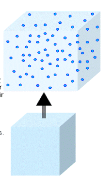
- ACondensation
- BRelief Precipitation
- CConvectional Precipitation
- DFrontal Precipitation
44Why is air cooler at higher elevations?
- AThere is less air pressure.
- BIt is farther from the ground, so it is colder.
- CIt is closer to the sun, so it is actually warmer.
- DAir is the same temperature everywhere in the atmosphere.
45What type of precipitation is shown?
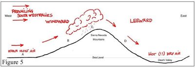
- ACondensation
- BRelief
- CConvectional
- DFrontal
46What type of precipitation is shown?
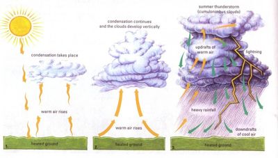
- ACondensation
- BRelief
- CConvectional
- DFrontal
47What type of precipitation is shown in the picture?
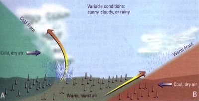
- ACondensation
- BRelief
- CConvectional
- DFrontal
48When moist air rises up the windward slope of a mountain, what type of precipitation could we expect?
- ACondensation
- BRelief
- CConvectional
- DFrontal
- ACondensation
49When heat from the sun causes warm moist air to rise, what type of precipitation would we expect?
- ACondensation
- BRelief
- CConvectional
- DFrontal
50When a cool air mass meets a warm air mass, the warmer air mass is forced up and over the cool air mass. What type of precipitation is this?
- ACondensation
- BRelief
- CConvectional
- DFrontal
Informationen
- Beschreibung
- A quiz for Unit 2. When you have answered all of the questions you need to submit. Once you see your mark select the button that says REVIEW QUIZ. This shows you all of the questions, gives you the correct answer and your answer.
- Autor
- gstoneman
- Sprache
- English
- Aufrufe
- 363
- Bewertung
- Noch keine Bewertungen Bewerte dieses Quiz