
Karteikarten
GIS
Karten in diesem Stapel (33)
- 1Was zeichnet spatial reference aus ?- The coordinate system (GCS or PCS & VCS)
-The spatial extent covered by the dataset (Ausdehnung)
- Coordinate prescision with coordinate are stored (Koordinatengenauigkeit)
-Processing tolerances (Bearbeitungstoleranz) - 2Was enthält das Vertikal-Koordinatensystem (VCS) (Vertical coordinate system)- Linear unit of measure (i.d.R. m or ft)
- Geodectic or vertical Datum
- Axis direction
-Vertical shift (verschiebung) - 3Was umfasst das Projizierte Koordinatensystem (PCS) ?- GCS
- Projection ( and project. parameters)
- Linear unit measure ( usually m or ft) - 4Was beinhaltet ein Geographisches Koordinatensystem ( GCS)?- Angular unit of measur (usually degrees)
- Prime median
- Datum (including spheroid) - 5Was geben Koordinatensysteme an? Coordinate system specify- A Projected or Geographic measurment framework
- Units of measurment
- A defined map projection
- Datums and spheriod, plus possible shift, central meridians and standard parallels. - 6Was ist der Tisso Index ?A method of investigating how map projections can distort the Earths surface going from a 3D to a 2D projection.
- 7What means " Great circle" ?= shortest distance between two points an a sphere ( called a Geodesic in Mathematics)
- 8Wie lautet das Datum vom Mittelpunkt der Erde?Ellipsoid - GRS 80
Datum - NAD 83 - 9Was versteht man unter "Datum" ?Datums are collections of poinst of "known" accuracy that are used to georefernce map data
- 10Wie liegen die semi-minor axis & semi-major axis ?semi-minor
I
I
-----------
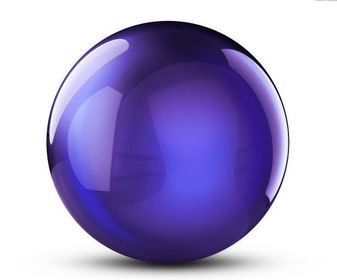
semi-major - 11—Sphere
- 12—Geoid
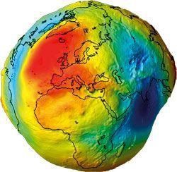
- 13—Ellipsoid

- 14What is Remote Sensing?"The science and art of obtaining useful information about an object, area or phenomenon through the analysis of data acquired by a device that is not in contact with the object, area or phenomenon under investigation"
- 15Was ist GIS?"GISs are simultaneously the telescope, the microscope, the computer and the Xerox machine of regional analysis and synthesis of spatial data"
- 16Nennen sie 4 Eigenschaften von Projectionen1. Angular conformity, or preservation of shapes ( conformal proj.)
2. Preservaton of distance ( equivalent proj.)
3. Preservation of area ( equivalent proj.)
4. Preservation of direction (azimuthal proj.) - 17Was ist Lidar?-Lidar ist a laser based active remote sensing technique that can operate from space based, airbone or ground based plattforms and provide very accurate 3D data.
- It requires an emmitter-reciver, plus accurate GPS and IMU information
- It can rapidly provide, bare earth high resolution DEM.
- Uses include geomorphological mapping and fault identifikaton and analysis - 18Slope and AspectThe rate of change of elevation in both the x and y direction can be used to identify the direction and magnitude of steppest gardient
- 19Was ist das?TIN vector data structure
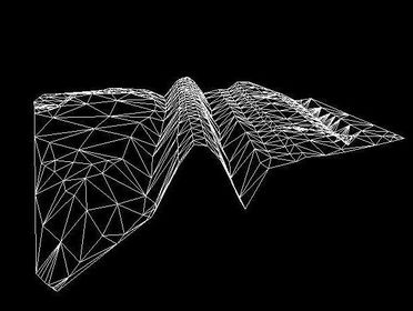
- 20—DEM vector data structure
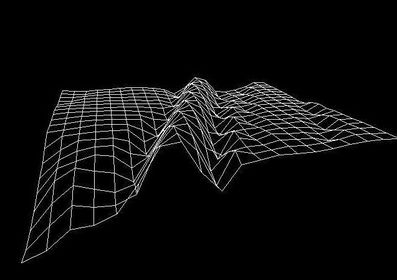
- 21What means TINsTriangulated Irregular Networks
" A vector data structure that partitions geographic space into contiguous, non-overlappig triangles. The vertices of each triangle are sample data points with x-,y-,z- values." - 22Pro Vector- Data can be represented in its original resolution
-requires les storage space
- Topological relationships maintained
- Geographical output visually pleasing - 23Contra Vector- More complex data structure
- inefficient for RS data
- Some spatial analysis procedures are complex an process intensive
- overlaying multi. vector maps is often time consuming - 24Pro Raster-Simple data structure
- Efficent for RS or scanned data
- Simple spatial analysis procedures - 25Contra Raster- Requires greater storage space
- Graphical output my be less pleasing
- Projection transformations difficult - 26Für was steht DTM?Digital Terrain Model
(Digitales Geländemodel) - 27Für was steht DEM?Digital Elevation Model
(Digitales Höhenmodel) - 28Pro und Contra Device inputpro:
- fast
-Less chance of error
- can be done in the field with wireless potential
contra:
-Requires equipment
-More specialist expertise
- Limited information - 29Pro und Contra Scanningpro:
-Format adaptible
- Good for converting paper products..
- fast
contra:
-Possible distortion errors
- Expensive...?
-Requires equipment - 30Pro und contra Keyboard entrypro:
-Format adaptible
-Good for tables of raw data
-User understanding
contra:
- Time consuming
-Prone to error - 31Pro und Contra DigitisingPro:
-Format adaptible
-Good fpr converting paper products
contra:
- Time consuming
- Prone to error
- Expensive
- Requires equipment - 32Abstracting the real World: Problems to be considered- The real World is dynamic, not static
- some features are continuous, some not
- The scale of the realworld my not match our data - 33What includes GIS ?-Coordinate systems can be GCS, PCS or VCS
- PCS are GCS that habe undergone proj. and given prativular spatial attributes.
- The Spatial Reference System of a GIS includes a coordinate system, extents resolution and tolerence
Informationen
- Beschreibung
- Klausurvorbereitung
- Erstellt von
- Weltraumkatze Fanroth · Mär 2016
- Aktualisiert
- 23 Mär 2016
- Aufrufe
- 160
- Bewertung