
Karteikarten
Geology 101 Final
Karten in diesem Stapel (138)
- 1"Pangaea" refers to:a supercontinent that broke apart
- 2A serious problem with the continental drift idea was that:it provided no workable mechanism for the continents to move
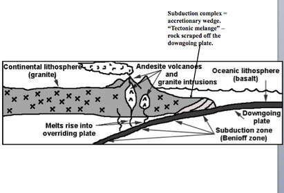
- 3An accretionary wedge of tectonic melange (a subduction complex) gets plastered onto a continent along a __________.convergent boundary
- 4California's San Andreas fault is an example of a:transform boundary
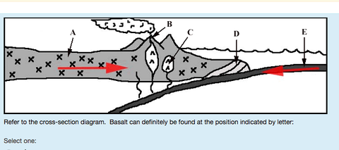
- 5—E
- 6—B
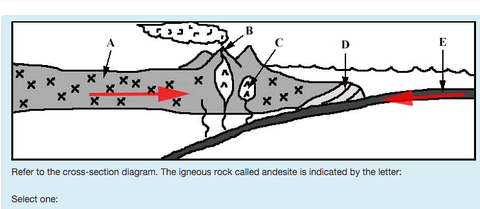
- 7—C
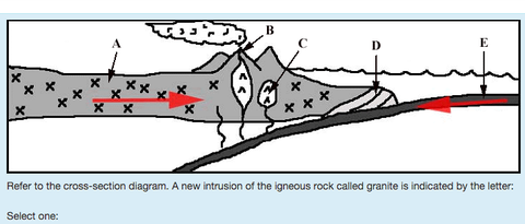
- 8—B
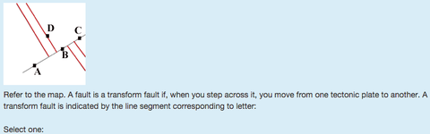
- 9—X
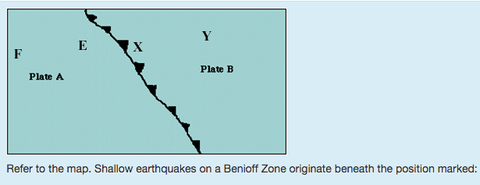
- 10—Plate A
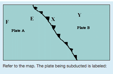
- 11The asthenosphere is:a weak layer of the mantle
- 12The continental drift idea is most closely associated with:Alfred Wegener
- 13The extinct "giant seed fern" whose fossils were found on all the southern continents plus India was:glossopteris
- 14The freshwater-swimming reptile whose fossils, found on both sides of the Atlantic, were used to support the idea of Continental Drift was:mesosaurus
- 15The lithospheric plates move mainly or in part because of:convection in the aesthenosphere
- 16The oldest rocks in oceanic crust are less than ~ 200 M.Y. old. Why?older seafloor has been subducted
- 17The oldest rocks making up the seafloor are found:near the shore
- 18Volcanic activity associated with subduction may be found:in the Cascade Mountains
- 19Which of these is a divergent boundary?mid-ocean ridge
- 20Which term means essentially the same thing as "divergent boundary?"spreading center
- 21What lived in freshwater; would not have had a physiology that could tolerate long periods of salt water immersion. Could not have crossed salty oceans ?Mesosaurus
- 22Fossils of extinct “giant seed fern” Glossopteris found in what continents?South America, Africa, Australia, Antarctica, and India.
- 23Could birds have carried Glossopteris seeds across oceans?Birds had not evolved yet when Glossopteris lived
- 24Rocks on all southern continents plus India were ________ in Late Paleozoic Era.Glaciated
- 25What was a better model than continental drift?plate tectonic theory
- 26What is Plate tectonic theory?Earth’s lithospheric plates are riding on the flowing aesthenosphere; continents and ocean basins are being carried along.
Explains all Wegener's evidence.
Provides workable mechanism for continents to move.
Late 1960s - present. - 27Lithosphere (crust + upper mantle) is broken into about a dozen major slabs called ?"tectonic plates" (or "plates")
- 28what are solid and rigid are made of the crust plus the upper mantle "float" on the asthenosphere ?Plates
- 29What is weak and flows due to convection?Asthenosphere
- 30Plates meet along which 3 kinds of boundaries?divergent
convergent
transform - 31Divergent boundary = ? = ? = ?Divergent boundary = spreading center = mid-ocean ridge (M.O.R.) = rift.
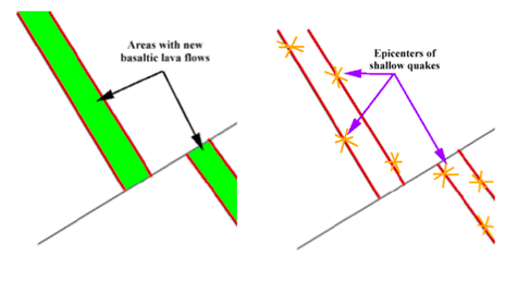
- 32Basaltic lava flows and shallow quakes occur at ________ boundaries.Divergent
- 33How fast do plates move?Plates move at about the rate of a growing fingernail – a few inches per year, on average
- 34In places, _______ poke above sea level (e.g. IcelandMid ocean ridges (MORs)
- 35Volcanic activity and quakes at MORs Diagram *
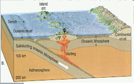
- 36Convergent boundary = ?Convergent boundary = subduction zone.
- 37What is a Convergent boundary?Plates collide (converge) and the denser plate dives beneath the less-dense plate.
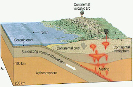
- 38—Oceanic-continental convergence
- 39—Oceanic-oceanic convergence
- 40—Continental-continental convergence
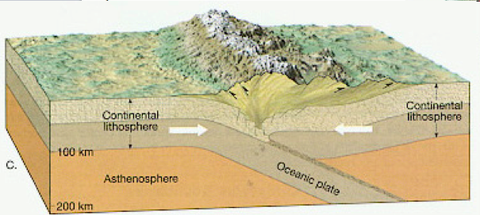
- 41Benioff zonetilted zone of quakes marking subduction zone.
- 42Subduction zone is marked by ________, the deepest parts of the oceans.Oceanic Trench
- 43When magma rises into over-riding plate, it produces _____ & ______ ?granite intrusions and andesite volcanoes in a continental volcanic arc
- 44Diagram *
- 45-subduction zone is farther out to sea, so oceanic crust is subducted under other oceanic crust.Oceanic-oceanic collision
- 46Chain of andesitic volcanoesvolcanic island arc
- 47Diagram*
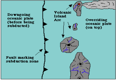
- 48Examples of Andesite VolcanoesWestern part of Aleutian trench
Western Aleutian Islands
Japan Trench
Japanese islands--andesite volcanoes (e.g. Fujiama) erupting onto oceanic crust in the overriding plate. - 49Diagram*
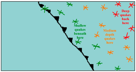
- 50Transform Plate Boundary = ?Transform Fault
- 51—Normal Fault
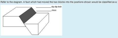
- 52—Reverse Fault
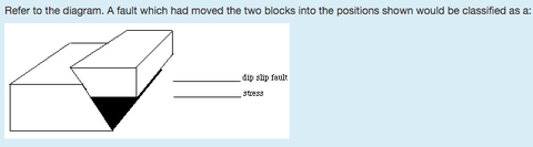
- 53—left-lateral strike-slip fault
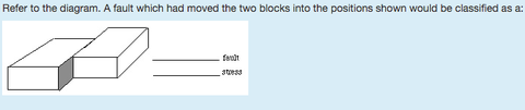
- 54—the block on the right
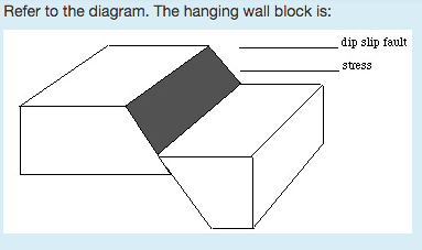
- 55—The block on the right
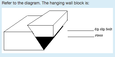
- 56—tension
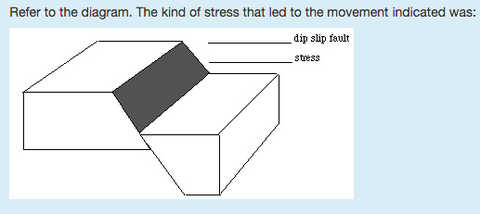
- 57—compression
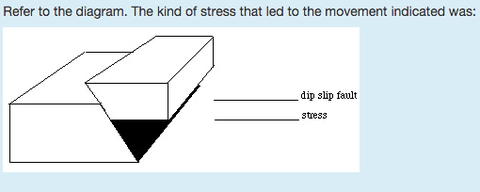
- 58—shear
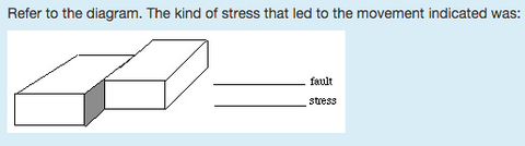
- 59—syncline
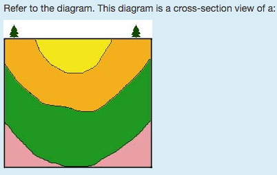
- 60—Folded into an anticline
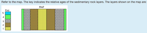
- 61—Compression
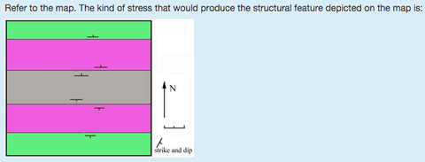
- 62—compression
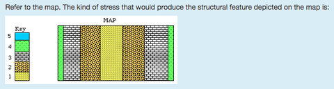
- 63—compression
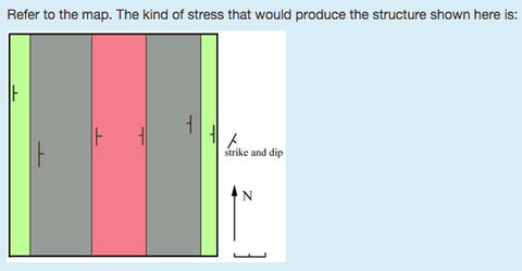
- 64—East plunging syncline
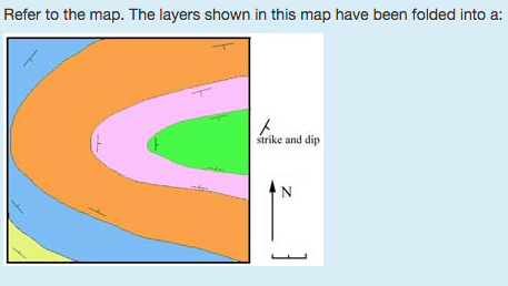
- 65—folded into a syncline
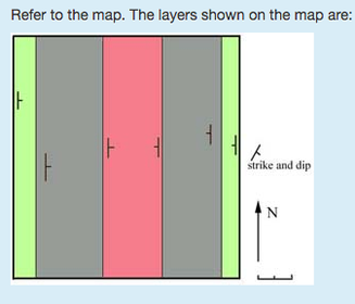
- 66—Folded into an anticline
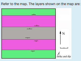
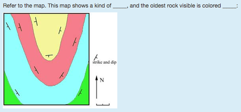
- 67—Green
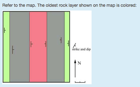
- 68—Gray
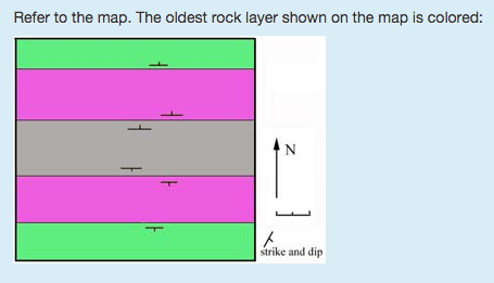
- 69—Dome, Purple
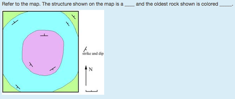
- 70—Anticline, Yellow
- 71What great earthquake of 1906 ushered in modern era of seismic research.San Fransisco
- 72Where was the The 1964 "Good Friday" earthquake?Anchorage, Alaska
- 73Earthquakesvibrations of Earth caused by rapid release of energy stored in strained rocks. (Earth vibrates as waves move through.)
- 74Focus (Earthquakes)Focus = point of first breakage.
(Plural = foci.) - 75EpicenterEpicenter = point on Earth’s surface directly above focus.
- 76Used to detect earthquakes?seismographs
- 77SeismogramSeismogram = record of a seismograph
- 783 main types of seismic waves:1. Primary waves (P waves): very fast compressional waves.
2. Secondary waves (S waves): fast shear waves (transverse waves).
3. Surface waves (L waves): slower moving transverse waves confined only to surface layers of Earth. - 79P WavesP waves are body waves: move through interior (“body”) of Earth.
- 80S WavesAre body waves (travel through Earth’s interior).
S waves are unable to travel through liquids (e.g. molten rock). - 81Which waves are not received by seismographs on opposite side of Earth, showing that Earth has a molten outer core.S Waves
- 82L WavesMuch like ocean waves ground moves in orbital patterns that die out with depth.
Not body waves, surface waves. - 83Which waves are the least destructive?P Waves
- 84buildings damaged by ground motions produced by ? and ? waves.S and L waves
- 85P waves are faster Diagram *
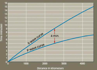
- 86When you want to pin down the epicenter exactly.Use the method of triangulation.
- 87Finding epicenter of a quakeCan find epicenter by triangulation if P and S waves from same quake were received by seismographs at 3 different locations).
- 88Aftershockssmaller quakes that happen within several days after larger quake, and take place in same area as the larger quake. “Adjustments.”
- 89Amplitude(“height”) of wave on seismogram is related to amount of ground motion at seismograph.
- 90Magnitude of the QuakeAmount of ground motion is related to energy released in the quake
- 91Used to measure magnitude of earthquakesRichter Scale
- 92Each increase of one unit on richter scale of magnitude means waves are ? times higher.10
- 93Each step of Richter magnitude corresponds to a fold increase in energy released.30
- 94Tsunami(seismic sea waves), can move out at great speed through ocean water if seafloor is disturbed by a quake. When tsunami approach shore, wave height can increase to more than 50 feet.
- 95LithosphereThe ground. Least dense, floats on Asthenosphere, oceanic and continental lithosphere. Rigid and thin.
- 96Displacement/ slipthe amount of movement on a fault
- 97How are materials transported in rivers and streams?Materials are transported through:
➢ dissolution(dissolve in water),
➢ In suspension(tiny solid grains that swirl along water without setteling to the floor,
➢ Bed loads(large particles that bounce along the bottom). - 98A ridge of sand projecting part way across a bay is a:a spit
- 99On a particular day, waves approaching a coast have wavelengths of about 60 feet. Sediments on the seafloor will not be disturbed if the water is deeper than about:30 feet
- 100One result of wave refraction is that:wave energy is concentrated in headlands
- 101Over the next several decades, it is predicted that the temperature of the atmosphere will _______, causing sea level to _______.rise, rise
- 102The bending of waves in shallow water is called:refraction
- 103The movement of water within the surf zone parallel to the shore is called __________.longshore currrent
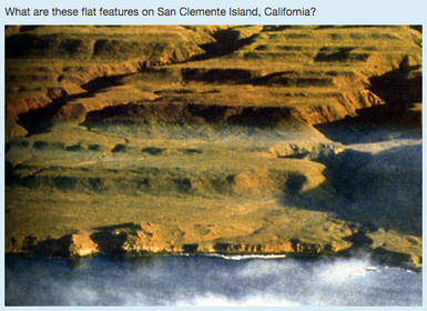
- 104—elevated marine terraces
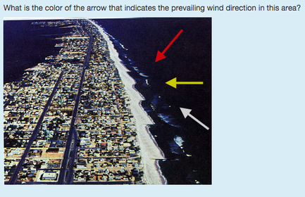
- 105—Red
- 106Which feature(s) would indicate that the land had been uplifted or that sea level had fallen?elevated marine terrace
- 107—Old Man River
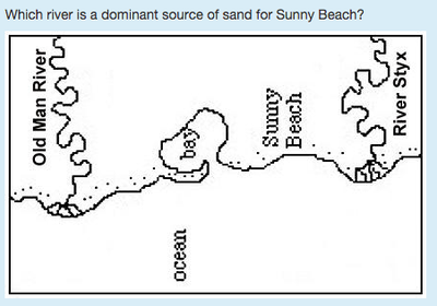
- 108Barrier islands are more common along the Pacific coast of the U.S. than along the Atlantic Coast. T or FFalse
- 109T or FTrue
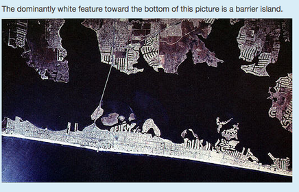
- 110A deposit of till that results from merging of the lateral moraines of two glaciers is a(n):medial moraine
- 111—A drumlin
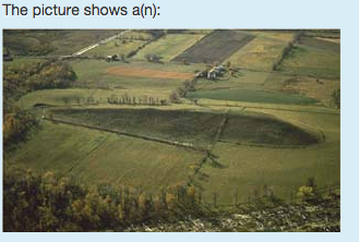
- 112Which glacial features is NOT a depositional feature?Cirque
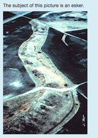
- 113Which is NOT made of till?Esker
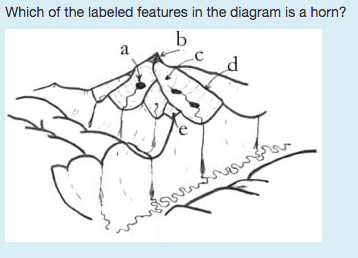
- 114—C
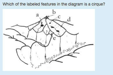
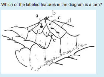
- 115—B
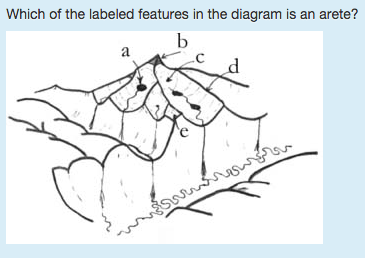
- 116—A
- 117—D
- 118—True
- 119A(n) __________ is a meander that has been completely separated from a river.Oxbow
- 120For a stream of a given size, capacity (the maximum load of solid particles that a stream can transport) is determined by the stream's __________.Velocity
- 121—C
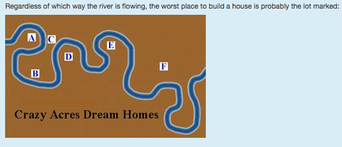
- 122The deepest level to which a stream can erode its channel is referred to as __________.Base Level
- 123—Entrenched Meander
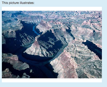
- 124—Location of a natual Levee
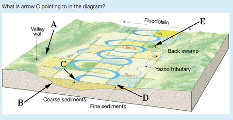
- 125Which of the following factors influences a stream's velocity?a. channel shape
b. channel size
c. gradient
d. discharge - 126A surface that represents a gap in the rock record of time caused by erosion or non-deposition is a(n):Unconformity
- 127If a radioactive isotope has a half-life of 4 million years, the amount of parent material left after 12 million years is what fraction (or percentage) of the original amount?1/8
- 128Placing events in their correct sequence as determined by their position in the geologic record is:Relative Dating
- 129—Granite
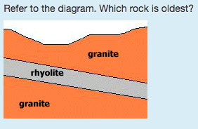
- 130—Sandstone
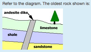
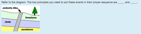
- 131—superposition/cross-cutting relationships
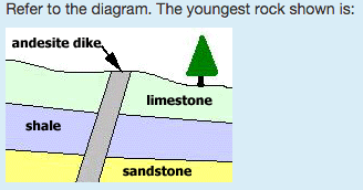
- 132—andesite
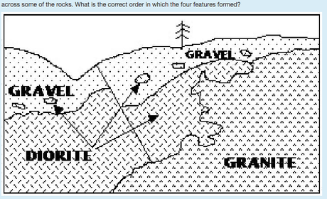
- 133—diorite, gravel, fault, granite
- 134correlationThe process by which rocks of the same relative age are matched up from area to area is known as:
- 135What fundamental principle states that the oldest layer is on bottom, and the layers get younger as you go up?Superposition
- 136When you observe an outcrop of steeply inclined sedimentary layers, which principle allows you to assume that the beds were tilted after they were deposited?original horizontality
- 137Which principle indicates that sediment extends in all directions until it gradually pinches out or terminates against the edge of a depositional basin?Lateral Continuity
- 138Which rule lets you conclude that an igneous rock that cuts through a sedimentary rock must be younger than that sedimentary rock?Cross cutting relationships
Informationen
- Beschreibung
- Karteikarten am Geology 101 Final, erstellt von Kimberlee Lizako am 13/12/2015.
- Erstellt von
- Kimberlee Lizako
- Aufrufe
- 10
- Bewertung