
Mindmap
RIVER SEVERN
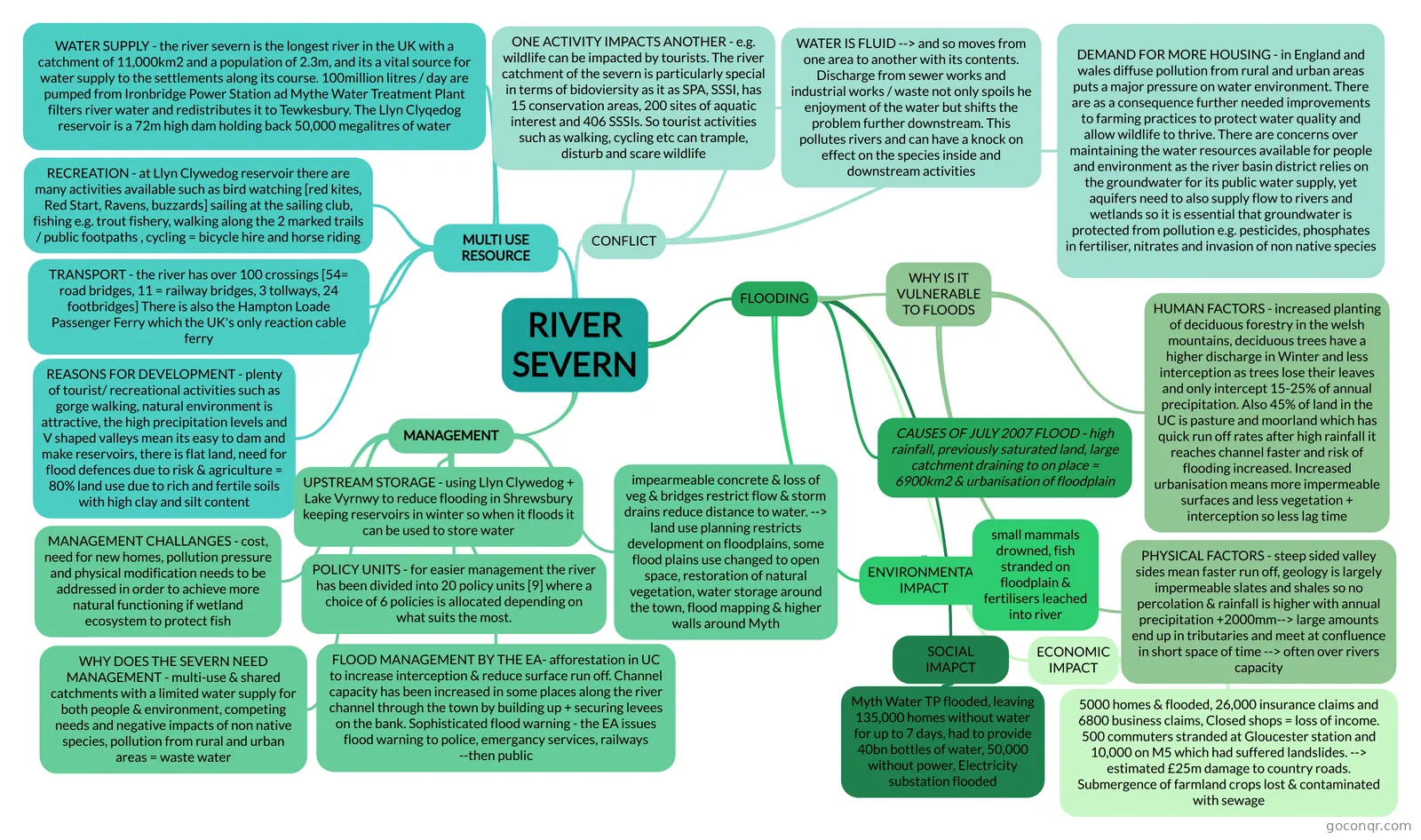
Mind map: River Severn
Inhalt der Mindmap
RIVER SEVERN
MULTI USE RESOURCE
- WATER SUPPLY - the river severn is the longest river in the UK with a catchment of 11,000km2 and a population of 2.3m, and its a vital source for water supply to the settlements along its course. 100million litres / day are pumped from Ironbridge Power Station ad Mythe Water Treatment Plant filters river water and redistributes it to Tewkesbury. The Llyn Clyqedog reservoir is a 72m high dam holding back 50,000 megalitres of water
- RECREATION - at Llyn Clywedog reservoir there are many activities available such as bird watching [red kites, Red Start, Ravens, buzzards] sailing at the sailing club, fishing e.g. trout fishery, walking along the 2 marked trails / public footpaths , cycling = bicycle hire and horse riding
- TRANSPORT - the river has over 100 crossings [54= road bridges, 11 = railway bridges, 3 tollways, 24 footbridges] There is also the Hampton Loade Passenger Ferry which the UK's only reaction cable ferry
- REASONS FOR DEVELOPMENT - plenty of tourist/ recreational activities such as gorge walking, natural environment is attractive, the high precipitation levels and V shaped valleys mean its easy to dam and make reservoirs, there is flat land, need for flood defences due to risk & agriculture = 80% land use due to rich and fertile soils with high clay and silt content
CONFLICT
- ONE ACTIVITY IMPACTS ANOTHER - e.g. wildlife can be impacted by tourists. The river catchment of the severn is particularly special in terms of bidoviersity as it as SPA, SSSI, has 15 conservation areas, 200 sites of aquatic interest and 406 SSSIs. So tourist activities such as walking, cycling etc can trample, disturb and scare wildlife
- WATER IS FLUID --> and so moves from one area to another with its contents. Discharge from sewer works and industrial works / waste not only spoils he enjoyment of the water but shifts the problem further downstream. This pollutes rivers and can have a knock on effect on the species inside and downstream activities
- DEMAND FOR MORE HOUSING - in England and wales diffuse pollution from rural and urban areas puts a major pressure on water environment. There are as a consequence further needed improvements to farming practices to protect water quality and allow wildlife to thrive. There are concerns over maintaining the water resources available for people and environment as the river basin district relies on the groundwater for its public water supply, yet aquifers need to also supply flow to rivers and wetlands so it is essential that groundwater is protected from pollution e.g. pesticides, phosphates in fertiliser, nitrates and invasion of non native species
FLOODING
- WHY IS IT VULNERABLE TO FLOODS
- HUMAN FACTORS - increased planting of deciduous forestry in the welsh mountains, deciduous trees have a higher discharge in Winter and less interception as trees lose their leaves and only intercept 15-25% of annual precipitation. Also 45% of land in the UC is pasture and moorland which has quick run off rates after high rainfall it reaches channel faster and risk of flooding increased. Increased urbanisation means more impermeable surfaces and less vegetation + interception so less lag time
- PHYSICAL FACTORS - steep sided valley sides mean faster run off, geology is largely impermeable slates and shales so no percolation & rainfall is higher with annual precipitation +2000mm--> large amounts end up in tributaries and meet at confluence in short space of time --> often over rivers capacity
- ENVIRONMENTAL IMPACT
- small mammals drowned, fish stranded on floodplain & fertilisers leached into river
- SOCIAL IMAPCT
- Myth Water TP flooded, leaving 135,000 homes without water for up to 7 days, had to provide 40bn bottles of water, 50,000 without power, Electricity substation flooded
- ECONOMIC IMPACT
- 5000 homes & flooded, 26,000 insurance claims and 6800 business claims, Closed shops = loss of income. 500 commuters stranded at Gloucester station and 10,000 on M5 which had suffered landslides. --> estimated £25m damage to country roads. Submergence of farmland crops lost & contaminated with sewage
- CAUSES OF JULY 2007 FLOOD - high rainfall, previously saturated land, large catchment draining to on place = 6900km2 & urbanisation of floodplain
- WHY IS IT VULNERABLE TO FLOODS
MANAGEMENT
- MANAGEMENT CHALLANGES - cost, need for new homes, pollution pressure and physical modification needs to be addressed in order to achieve more natural functioning if wetland ecosystem to protect fish
- WHY DOES THE SEVERN NEED MANAGEMENT - multi-use & shared catchments with a limited water supply for both people & environment, competing needs and negative impacts of non native species, pollution from rural and urban areas = waste water
- UPSTREAM STORAGE - using Llyn Clywedog + Lake Vyrnwy to reduce flooding in Shrewsbury keeping reservoirs in winter so when it floods it can be used to store water
- POLICY UNITS - for easier management the river has been divided into 20 policy units [9] where a choice of 6 policies is allocated depending on what suits the most.
- FLOOD MANAGEMENT BY THE EA- afforestation in UC to increase interception & reduce surface run off. Channel capacity has been increased in some places along the river channel through the town by building up + securing levees on the bank. Sophisticated flood warning - the EA issues flood warning to police, emergancy services, railways --then public
- impearmeable concrete & loss of veg & bridges restrict flow & storm drains reduce distance to water. --> land use planning restricts development on floodplains, some flood plains use changed to open space, restoration of natural vegetation, water storage around the town, flood mapping & higher walls around Myth
Informationen
- Beschreibung
- Mindmap am RIVER SEVERN, erstellt von Liv Pearce am 16/05/2016.
- Erstellt von
- Liv Pearce
- Aufrufe
- 4
- Bewertung