
10991046
Beschreibung

Mindmap von Mollie Blakey, aktualisiert more than 1 year ago

|
Erstellt von Mollie Blakey
vor etwa 9 Jahre
|
|
Natural and Tectonic Hazards- Geo MindMap
- Definition. of a hazard, differences
and types of hazards
- Definition: A perceived natural event which has the
potential to threaten both life and property. It can
only become§ a hazard if our lives are at right.
- Types with Examples
- Tectonic: Movement of the
earth's plate and internal
change. E.g. Earthquakes,
Tsunamis and Volcanic
eruption.
- Atmospheric: Weather and
climate are involved. E.g
Hurricanes, Flooding and
Tornados.
- Geomorphological:
Related to surface
process. E.g Mud Slides,
Avalanches and
Quicksand.
- Biological: Involving living
organisms. E.g. Wildfires and
Bushfires.
- Tectonic: Movement of the
earth's plate and internal
change. E.g. Earthquakes,
Tsunamis and Volcanic
eruption.
- Differences of Hazards: Areas
impacted, warning signs, scales
impact, duration, a speed of set and
regularity.
- Definition: A perceived natural event which has the
potential to threaten both life and property. It can
only become§ a hazard if our lives are at right.
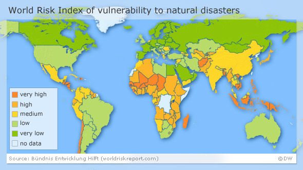
- World Risk Index Vulnerability (Worst outcome of
something happening) to natural disasters.
- Describe: I can tell the central Africa
experiences high to a very high vulnerability
to natural disasters. Also in Southeast Asia
can experience can medium to high
vulnerability of natural disasters. However,
North America, Western European and
Australia can experience low to very low
vulnerability to natural disasters to
happen.
- Explain: Central Africa are more vulnerable to get
disasters because they have fewer people who are
educated, less prevention and are a LEDC Country.
Whilst Southeast Asia such as Japan they have
money meaning to put in place on their
infrastructure e.g stronger buildings, to stand up
to the worse of earthquakes, even they can not
be fully prepared for a tsunami and the devasting
effects expect early warning system.
- Describe: I can tell the central Africa
experiences high to a very high vulnerability
to natural disasters. Also in Southeast Asia
can experience can medium to high
vulnerability of natural disasters. However,
North America, Western European and
Australia can experience low to very low
vulnerability to natural disasters to
happen.
- Risk and Vulnerability Definition
- Risk: The probability of a
hazard event occurring and
creating a loss of lives and
livelihoods.
- Vulnerability: How exposed you may be or
how exposed an area can be. The tendency
of place, group or society.
- Risk: The probability of a
hazard event occurring and
creating a loss of lives and
livelihoods.
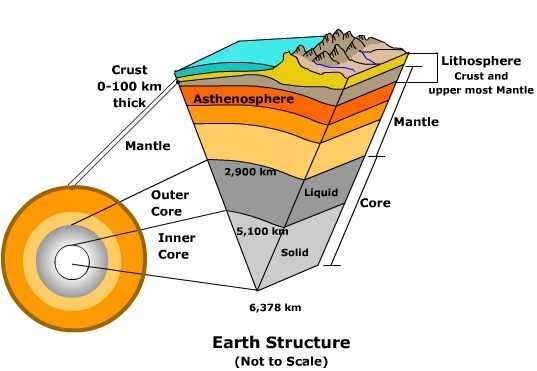
- The Earth structure.
- Asthenosphere: Is a low-velocity layer and is a
solid with plastic parts, it moves
slowly.
- Lithosphere: A rigid zone of the crust and is the top part of
the upper mantle. It's broken into plates and carried on a
less rigid mantle is close to melting.
- Upper Mantle: Has a solid silicate called
peridotite, which lies in of Asthenosphere
whilst the part is in the Lithosphere
- Inner Core: Solid of iron and
Nickelm where they it's constant
radioactive heat made.
- Lower Mantle: Is a solid silicate material an is increased
in pressure and temperature.
- Outer Core: Liquid nickel layer and
where earth's electromagnetic is
made.
- Crust: Has two types of rocks mainly granite and
basalt at different densities but both are rigid
- Asthenosphere: Is a low-velocity layer and is a
solid with plastic parts, it moves
slowly.
- Plate Boundaries.
- Constructive Margin: When two plates move apart
from each other and magma comes out. E.g. Iceland,
here new land is made.
- Destructive Margin: Is when one plate goes under the
other way. Making magma to push out the surface. E.g
The Andes where the Nazca plate subducts under South
America.
- Conservative Margin: Where two plates slide next to each
other, This can be the same direction or opposite. Only
make shallow earthquakes. E.g San Andreas.
- Constructive Margin: When two plates move apart
from each other and magma comes out. E.g. Iceland,
here new land is made.
- Nepal Earthquake
- When, How and Where: 25th April 2015, 11:56 PM
local time (GMT) last 2 minutes. The waves were felt
13 meters away. Happened near the capital
Katmandu. Plate boundaries involved Indo-Australian
and the Eurasian plate (collision margin)
- Short term and long term effects.
- Long-term: The overall damage had costed
the Nepal government around $10 billion
nearly half it's domestic product of $19.2
billion.
- Short term: 1 million people were homeless.
Water, food and supply were reduced due to
the earthquake. 352 aftershock after a second
earthquake. Some historic buildings were destroyed.
- Long-term: The overall damage had costed
the Nepal government around $10 billion
nearly half it's domestic product of $19.2
billion.
- Aid: Internationa;l help such as the red
cross helped evacuate the people who were
hurt or badly injured to safety.
- When, How and Where: 25th April 2015, 11:56 PM
local time (GMT) last 2 minutes. The waves were felt
13 meters away. Happened near the capital
Katmandu. Plate boundaries involved Indo-Australian
and the Eurasian plate (collision margin)
Medienanhänge
Möchten Sie kostenlos Ihre eigenen Mindmaps mit GoConqr erstellen? Mehr erfahren.