
Mindmap
River Landscape
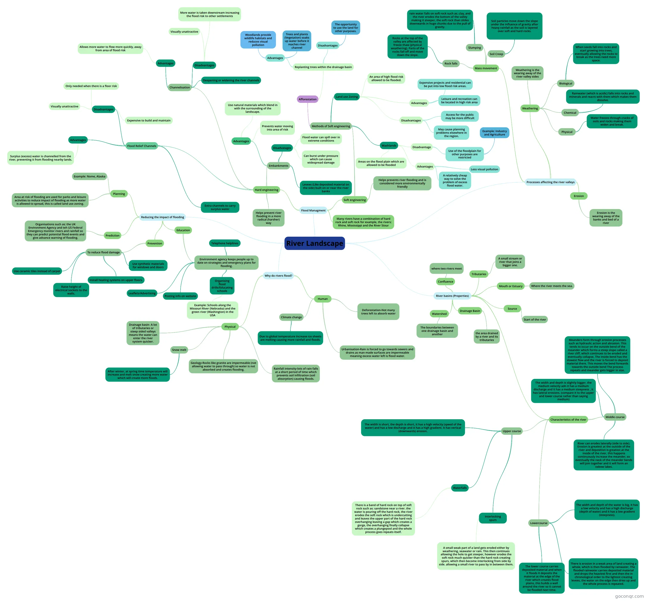
Mind map: River Landscape
Inhalt der Mindmap
River Landscape
River basins (Properties)
- Source
- Start of the river
- Tributaries
- A small stream or river that joins a bigger one.
- Confluence
- where two rivers meet
- Mouth or Estuary
- Where the river meets the sea.
- Watershed
- The boundaries between one drainage basin and another
- Drainage Basin
- the area drained by a river and its tributaries
- Characteristics of the river
- Upper course
- The width is short, the depth is short, it has a high velocity (speed of the water) and has a low discharge and it has a high gradient. It has vertical (downwards) erosion.
- Interlocking spurs
- A small weak part of a land gets eroded either by weathering, seawater or rain. This then continues allowing the hole to get steeper, however erodes the soft rock much quicker than the hard rock creating spurs, which then become interlocking from side by side. allowing a small river to pass by in between them.
- Waterfalls
- There is a band of hard rock on top of soft rock such as: sandstone near a river. the water is pouring off the hard rock, the river erodes the soft rock which is undercutting and leaves the upper part of the hard rock overhanging leaving a gap which creates a gorge, the overhanging finally collapse which creates a plungepool and the whole process goes repeats itself.
- Middle course
- The width and depth is slightly bigger, the medium velocity adn it has a medium discharge and it has a medium steepness , it has lateral erosions. (compare it to the upper and lower course rather than saying medium)
- Meanders form through erosion processes such as hydraulic action and abrasion. This tends to occur on the outside bend of the meander which forms a steep slope called a river cliff, which continues to be eroded and eventually collapse. The inside bend has the slowest flow and the river is forced to deposit material there. This moves the bend forwards towards the outside bend The process repeats and meander gets bigger in size.
- River can erodes laterally (side to side). Erosion is greatest at the outside of the river and deposition is greatest at the inside of the river, this happens continuously increase the meander, so eventually the neck of the meander bends will join together and it will form an oxbow lakes.
- Lowercourse
- The width and depth of the water is big, it has a low velocity and has a high discharge (depth of water) and it has a low gradient (steepness).
- There is erosion in a weak area of land creating a whole, which is then flooded by rainwater, The flooded rainwater carries deposited material and drops the heaviest first and then the in chronological order to the lightest creating levees, the water on the edge then dries up and the whole process is repeated.
- The lower course carries deposited material and when it floods it deposits the material at the edge of the river which creates flood plains, this builds a wall around the river so it cannot be flooded next time.
- Upper course
- Source
Processes affecting the river valleys
- Erosion
- Erosion is the wearing away of the banks and bed of a river
- Weathering
- Weathering is the wearing away of the river valley sides
- Physical
- Water freezes through cracks of soils and rocks making them widen and break.
- Chemical
- Rainwater (which is acidic) falls into rocks and minerals and reacts with them which makes them dissolve.
- Biological
- When seeds fall into rocks and start growing into trees, eventually allowing the rocks to break as the trees need more space.
- Mass movement
- Soil Creep
- Soil particles move down the slope under the influence of gravity after heavy rainfall as the soil is layered over soft and hard rocks.
- Slumping
- rain water falls on soft rock such as: clay, and the river erodes the bottom of the valley making it steeper, the soft rock than slides downwards in huge chunks due to the pull of gravity.
- Rock falls
- Rocks at the top of the valley are affected by freeze thaw (physical weathering). Parts of the rocks fall off and move down the slope.
- Soil Creep
- Erosion
Why do rivers flood?
- Physical
- Rainfall intensity-lots of rain falls at a short period of time which prevents soil infiltration (soil absorption) causing floods.
- Geology-Rocks like granite are impermeable (not allowing water to pass through) so water is not absorbed and creates flooding.
- Snow melt
- After winter, at spring time temperature will increase and melt snow creating more water which will create more floods.
- Drainage basin- A lot of tributaries or steep sided valleys means the water can enter the river system quicker.
- Human
- Deforestation-Not many trees left to absorb water
- Climate change
- Due to global temperature increase ice sheets are melting causing more rainfall and floods.
- Urbanisation-Rain is forced to go towards sewers and drains as man made surfaces are impermeable meaning excess water left is flood water.
- Physical
Reducing the impact of flooding
- Planning
- Area at risk of flooding are used for parks and leisure activities to reduce impact of flooding as more water is allowed to spread, this is called land use zoning.
- Example: Nome, Alaska
- Prediction
- Organisations such as: the UK Environment Agency and teh US Federal Emergency monitor rivers and rainfall so they can predict potential flood events and give advance warning of flooding.
- Prevention
- To reduce flood damage
- Use ceramic tiles instead of carpet
- Raise height of electrical sockets to the walls.
- Use synthetic materials for windows and doors
- Install heating systems on upper floors.
- To reduce flood damage
- Education
- Environment agency keeps people up to date on strategies and emergency plans for flooding.
- Leaflets/Advertising
- Posting info on website
- Telephone helplines
- Organising flood drills/Educating schools
- Example: Schools along the Missouri River (Nebraska) and the green river (Washington) in the USA
- Environment agency keeps people up to date on strategies and emergency plans for flooding.
- Planning
Flood Managment
- Soft engineering
- Helps prevents river flooding and is considered more environmentally friendly
- Methods of Soft engineering
- Afforestation
- Replanting trees within the drainage basin
- Advantages
- Trees and plants (Vegetation) soaks up water before it reaches river channel
- Woodlands provide wildlife habitats and reduces visual pollution
- Disadvantages
- The opportunity to use the land for other purposes.
- Advantages
- Replanting trees within the drainage basin
- Land use Zoning
- An area of high flood risk allowed to be flooded.
- Advantages
- Expensive projects and residential can be put into low flood risk areas.
- Leisure and recreation can be located in high risk area
- Disadvantages
- Access for the public may be more difficult
- May cause planning problems elsewhere in the region.
- Washlands
- Areas on the flood plain which are allowed to be flooded
- Advantages
- A relatively cheap way to solve the problem of excess flood water.
- Less visual pollution
- Disadvantage
- Use of the floodplain for other purposes are restricted
- Example: Industry and Agriculture
- Use of the floodplain for other purposes are restricted
- Afforestation
- Hard engineering
- Helps prevent river flooding in a more radical (harsher) way
- Flood Relief Channels
- Extra channels to carry surplus water
- Advantages
- Surplus (excess) water is channelled from the river, preventing it from flooding nearby lands.
- Disadvantages
- Visually unattractive
- Only needed when there is a floor risk
- Expensive to build and maintain
- Channelisation
- Deepening or widening the river channels
- Advantages
- Allows more water to flow more quickly, away from area of flood risk
- Disadvantages
- Visually unattractive
- More water is taken downstream increasing the flood risk to other settlements
- Embankments
- Levees (Like deposited material on the side) built on or near the river banks
- Advantages
- Use natural materials which blend in with the surrounding of the landscape.
- Prevents water moving into area of risk
- Disadvatages
- Flood water can spill over in extreme conditions
- Can burst under pressure which can cause widespread damage
- Many rivers have a combination of hard rock and soft rock for example, the rivers: Rhine, Mississippi and the River Stour
- Soft engineering
Informationen
- Beschreibung
- Mindmap am River Landscape, erstellt von Lamisha Chowdhury am 09/03/2016.
- Erstellt von
- Lamisha Chowdhury
- Aufrufe
- 8
- Bewertung