
Karteikarten
Earth Systems Midterm 3
Karten in diesem Stapel (73)
- 1Whats the difference between relative dating and numerical dating?relative dating : understanding the relative events; comparing 2 or more entities to determine which is older; non-specific
numerical dating : specifying the actual number of years that have passed since an event occurred - 2Principal of Uniformitarism"present is key to the past"
the same processes act throughout time, but possibly at different rates
good for general cases (river flow downhill)
bad for specific cases - 3Law of Superpositionmost sediments settle from water/wind
young rock material (sediment) is deposited on top of earlier, older deposits - 4Principle of HorizontalityLayers of sediment are generally deposited in a horizontal position
when/if tilted, you can identify the top surface by the characteristics that have embedded on the surface from the environment (ripples (wind), cracks (water)) - 5Principle of Cross-cutting Relationshipsigneous formation must be younger than rock it cuts across
the geologic feature which cuts another is the younger of the two features - 6What is Correlation?The matching of rocks of similar ages in different regions
- 7Correlation: LithostratigraphicMatching up continuous rock sequences
- 8Correlation: ChronostratigraphicMatching up rocks of the same age (usually done with fossils)
- 9Principle of Fossil Successionfossils succeed each other vertically in a specific, reliable order that can be identified over wide horizontal distances.
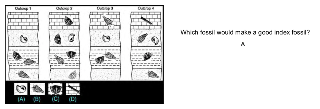
so, any time period can be recognized by its fossil content - 10What are index fossils??Short-lived, widespread organisms
if a fossil is everywhere, all at the same time period, and it died quickly, It gives a definite time period - 11What are Conformable Sequences?Layers of rock deposited without any interruption
- 12What does Unconformity mean?a gap or break in the rock record due to erosion/haults.
implies tectonic movement (uplift) - 13DisconformityStrata on either side of the unconformity are parallel, but the ages differ
(ages on either side of the contact are different, but no looks of interruption) - 14What are Contacts in Geological Terms?a contact is the surface over which two solid geological bodies, usually rocks, are in touch.
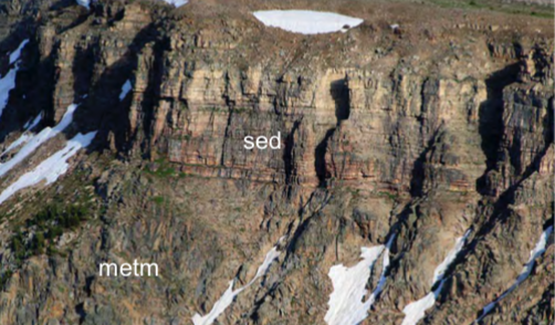
can tell much info on rocks, like the environment they were created in - 15Nonconformitymetamorphic/igneous rocks in contact with sedimentary strata
- 16How do we measure the Numerical Date of Rocks?common numerical dating relies on the rate of decay of radioactive isotopes in minerals
- 17Parent VS Daughter (isotopes)Parent - an unstable (decaying) radioactive isotope
Daughter - the isotopes that result from the decay of a parent - 18What does Half-life mean?the time required for one-half of the radioactive nuclei in a sample to decay
- 19Principle of Radiogenic Datingatoms that decay during one half-life is always the same (50%)
- 20How do Masses Move at the Surface? What Triggers them?material moves down slopes by the pull of gravity
the factors that drive the material downslope > factors that resist downslope movement
slopes lose strength over time through numerous events and near-failures
a trigger will cause the collapse (can be heavy rain, earthquakes, thawing frozen ground, humans) - 21Factors of Slope Failures1) slope angle : increase by downcutting of landscape by rivers or waves
2) slope composition: weathered, fractured rock, high [clay], unstable material
3) vegetation: presence of vegetation anchors unconsolidated material
4) weight: more weight = slope failure
5) water: little amount = holds material, lots water = reduces friction & adds weight - 22Internal Causes of Slope Failures ancient slip surfacessliding creates smooth, slick layer of ground-up material that can easily slide over and over again (especially when wet)
- 23Internal Causes of Slope Failures Exposed BeddingLayers at flatter angle than hillside --> bedding allows slippage
Layers at steeper angle than hillside --> difficult to slip - 24Internal Causes of Slope Failures Structures Within Rocks- not cemented together
- clay layers
- soft rock later on strong layer
- split apart by fractures - 25Exfoliationa decrease in cohesion
rocks that are buried compress into smaller volumes
rocks that are later uplifted to the surface expand in volume, fracture, and increase porosity --> reduces strength, increases openings for water weakens more - 26Weak Materials :Clays : form during chemical weathering of rocks
Expansive & hydrocompacting soils with clay
Quick clays : most mobile, weak solid, loosely packed, found where glaciers/oceans used to be - 27How does Water affect Rocks Integrity?weakens materials by:
1) weight: its heavier than the air that usually fills the pores of rocks
2) absorption: water is absorbed by clay minerals, decreases strength
3) Dissolving cement: can dissolve materials holding rock together
4) Piping: water can physically erode away materials
5) pore-water pressure: pressure ^ with increasing weight piled on top of rocks, too much pressure gives lift to sediments and makes it unstable - 28CreepSlowest, most widespread form of slope failure
swelling and shrinking of soil in response to:
freezing and expanding of water in pores
absorption of water = expansion of clay
heating by sun = inc. in volume
it will expand, then shrink straight downward due to gravity - 29Solifluctionpermafrost regions of steep slopes
sun thaws top layer of soil and it flows slowly over frozen subsoil - 30EarthflowRock layers tilt towards the sea, they have specific clay
the ocean waves erode toe and keep earth flow moving seaward
creates unstable land - 31SlidesMovement of block above failure surface
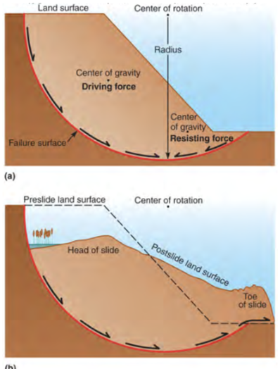
- 32Rotational Slides (Slump)move downward and outward above the curved slip surface, movement is rotational. toe moves upward on top of landscape. moves short distances
- 33Translational Slidesmove on planar slip surface (like a fault, joint, clay-rich layer)
moves as long as its on a declined surface
has different behaviours:
- remains block shaped
- deforms to form the debris slide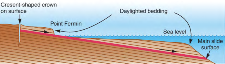
- 34Long-runout Debris Flowsmost dramatic, complex movement
massive rock falls that convert to highly fluid, rapid debris flows that travel far - 35Snow avalanchesbehaves like earth mass movements
small avalanches usually fail at one point, triggers more and more snow moving downhill
drier snow = faster avalanches - 36Loose-powder Avalancheslow cohesion, 95% of volume is pore space
- 37Slab AvalanchesSlabs of snow that break free, turns into flows on the way down
composed of different layers of ice that all have different strengths, this makes numerous potential failure surfaces - 38FallsElevated rock mass separates along a joint, bedding or weakness and falls downward through air in free fall until it hits ground
- 39Subsidenceground surface sags or drops as voids
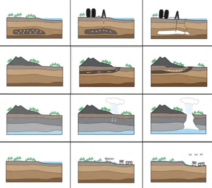
- 40Rock DissolutionCaverns formation will collapse when the groundwater levels drop
the support of the buoyant water holding up the cavern roofs is removed
forms sinkholes - 41Fluid WithdrawalWhen water is removed, buoyancy force is removed, loose sand will attain a tighter packing due to sediment grains = heavier
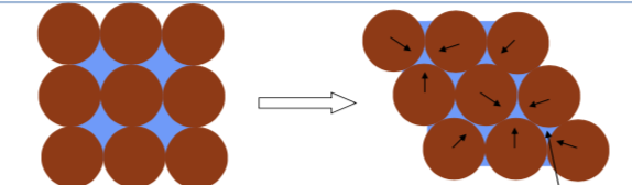
- 42Sediment Compactiona sediment progressively loses its porosity due to the effects of loading
- 43Mitigation of Mass MovementsRotational/Translational Landslides: unloading the head, reinforcing body, supporting toe
Flows of earth/snow: steering the flow by building walls/digging channels, decreasing slope angle (remove rock) - 44Hydrologic CycleThe movement of water between the ocean (hydrosphere), air (atmosphere), and land (lithosphere)
- 45Processes of the Hydrologic Cycleevaporation : the main way that water moves from the liquid state back into the atmosphere as vapour
precipitation: Precipitation is water released from clouds in the form of rain, freezing rain, sleet, snow, or hail
infiltration: water on the ground surface enters the soil
runoff : precipitation that did not get (infiltrated) absorbed into the soil, or did not evaporate, and therefore, made its way from the ground surface into places that water collect.
Evapotranspiration: vaporation and plant transpiration from the Earth's land and ocean surface to the atmosphere. - 46What is an Aquifer?a geologic unit that can store and transmit water
OR
a body of permeable rock that can contain or transmit groundwater. - 47What is an Unconfined Aquifer?an aquifer that has the ground surface as an upper bound
interacts with surface water, streams etc.
(has groundwater-surfacewater interactions) - 48What is a Confined Aquifer?an impermeable dirt/rock layer exists that prevents water from seeping into the aquifer
- 49What does Porosity mean and how does it affect the infiltration of water into material?Porosity = the measure of void space in a geological material
the lower the porosity (the more compact the material is), the less water that can be infiltrated - 50Definition of a Streama body of water that carries rock particles and dissolved ions, flowing down slope along a defined path
(the path is known as a channel) - 51How do Streams affect the Hydrologic Cycle and the environment?Streams carry most of the water that goes from the land to the sea, making it an important part of the water cycle
they carry dissolved ions into the oceans,
contribute to the erosional process, and it controls the surrounding landscape with weathering,
major source of water transportation for human settlements - 52What are the 3 Basic Parts of a Stream?1) valleys : sloping area around the stream
2) channel : bottom of the valley, where water flows
3) Floodplains : flat area in valley level with the top of the channel. (can be flooded) - 53What does Discharge mean?the volume of water passing any point on a stream
(Q = A x V)
discharge increases as more water is added (rainfall, groundwater seeping, etc).
as discharge increases, width, depth, and velocity also increase (cause overflowing), and the gradient decreases - 54The Cross Sectional Shape of Channelsvaries with position in the stream and the discharge
The deepest parts of a channel occur where the stream velocity is the highest
width & depth increase downstream due to discharge increasing downstream - 55Long profile of channelsa plot of elevation VS distance.
usually shows a steep gradient near the source of the stream, and a gentle gradient when it gets close to the mouth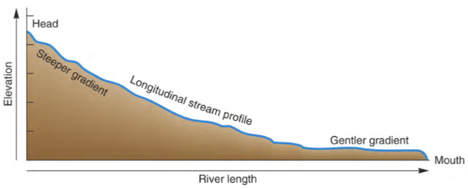
- 56How does friction affect the velocity of water in Streamsirregularities can occur due to resistant rock (causes friction)
Friction slows water along channel edges
Friction is greater in wider, shallower streams, and less in deeper, more narrow streams - 57What is the Base Level of Streams? What happens if there is an increase/decrease in base level?The level below which a stream cannot erode
increase in base level : due to extra rainfall, melting of glaciers etc. causes sea level rise, or land sinks into sea. results in a decrease in the gradient of the river valley and an increase in deposition
Decrease in base level : fall in sea level, or rise in land. results in steepening the gradient of the river, which increases rate of erosion - 58What does Graded Stream mean?A graded river is one in which, over a period of years, can reach an equilibrium state where channel geometry and hydraulic parameter enable the stream to transport its load without deposition or erosion
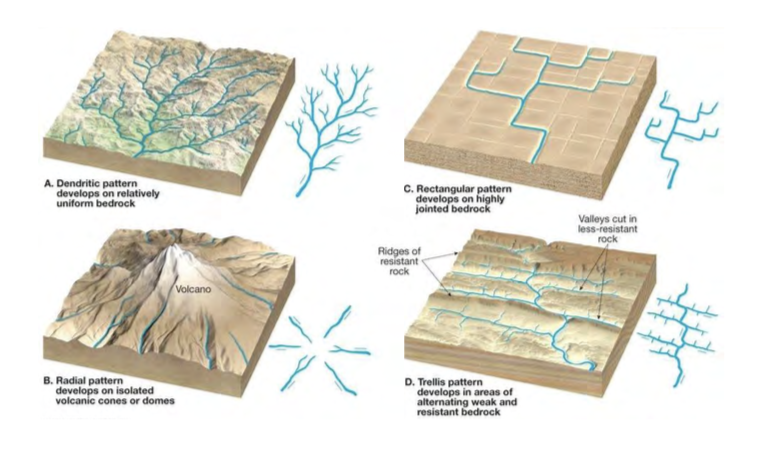
- 59Channel Patterns
- 60Stream Depositssudden decreases in velocity can result in sediment deposition by streams :
floodplain
levee
terrace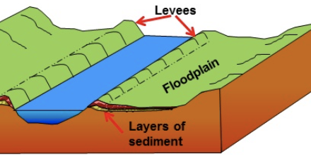
- 61Causes of Floodingoccurs when discharge of stream becomes too high to be accommodated in the normal stream channel
Precipitation, runoff, coastal flooding, and dam/levee failures can cause flooding - 62What is a Flood Stage?when the discharge increases, channel can become completely full. any discharge above this level will result in the river overflowing and causing a flood.
the stage at which the river will overflow its banks = flood stage - 63What is runoff?runoff = Precipitation - infiltration - interception - evaporation
water that is stored on leaves and branches of trees until it evaporates/water gets stored in ponds or lakes - 64What causes the increase in the amount of Runoff?The removal of vegetation decreases interception, which results in more runoff.
- 65What is the primary affects of Floods?high water velocity =
-> transport larger rocks, cars, houses, bridges, can carry away humans, etc
-> more erosion, which undermines bridges, levees, buildings
-> water damage = loss of crops
-> concentrate pollutants into water - 66What are the secondary affects of Floods?-> disruption of services
-> water and sanitation problems
-> gas and electrical problems
-> disruption of public transportation - 67What are the tertiary affects of Floods?-> location of rivers could change
-> destruction of wildlife habitat
-> erosion or deposition of sediment affecting farmland
-> job loss due to disruption of services
-> insurance rates increase - 68Flood Predicting : Statisticsdetermines the probability and frequency of high discharges that can cause flooding
monitor the annual discharge if river
rank the discharge events (1 is largest) - 69What does Pe & Pt stand for, and what is the difference between them?Pe = annual exceedence probability :
The probability of a certain flood occurance in any year.
ex. discharge equal to that of a 10yr food would have a probability of 10% (100 yr flood = 1%)
Pt = probability of occurrence over the entire time period - 70Flood Predicting : Mapping and Modelling of Landscapedetermine the extent of future floods from past floods
- 71Flood Predicting : Monitor Rainfall and Snowmeltonly good for short term predictions
- 72Flood Prevention & its problems1) increasing the cross-sectional area
2) straighten channel
(have to alter surrounding ecosystem)
3) line the channel to reduce friction
(can increase velocity)
overall, preventing floods has its problems, if an area is unable to flood naturally, it can alter the land that surrounds it negatively. - 73Benefits of Flooding-> Provides fertile soils with high rate of plant growth and diversity, richer agricultural harvests, and healthier forests
-> helps the habitat of a variety of fish and wildlife, including rare/endangered species
-> groundwater recharge, reducing sediment loads = better water quality
Informationen
- Beschreibung
- Der Nutzer hat seine Fachbereichs-Information gelöscht. Karteikarten am Earth Systems Midterm 3, erstellt von Gelöschter Nutzer am 01/04/2018.
- Erstellt von
- Gelöschter Nutzer · Apr 2018
- Aktualisiert
- 1 Apr 2018
- Aufrufe
- 17
- Verlauf
-
- Erstellt von abby Radske · 15 Mär 2018
- Kopiert von abby Radske · 1 Apr 2018
- Bewertung