
Karteikarten
Earth Systems - FINAL - Hydrogeology

Karten in diesem Stapel (36)
- 1Define Groundwaterwater found in pores and fractures in geological media below the surface
Classically defined as water below the water table - 2Where is groundwater found?Aquifers, Aquitards, Aquicludes
- 3Define Aquiferunderground layer of water-bearing rock (permeable)
A saturated geologic unit that readily transmits significant quantities of water - 4Define Aquitarda saturated geological unit that poorly transmits water in low quantities, which are not sufficient for a well
have low permeability - 5Define Aquicludea saturated geological unit that isnt able to transmit quantities of water
essentially impermeable - 6Porosity vs PermeabilityPorosity = how much of a rock volume is open space
Permeability = how easily a fluid an move through the porous rock - 7Define Hydraulic Conductivity (K)The measure of the permeability of a fluid passing through a porous rock (the coefficient of permeability)
high value = more permeable
low values = more impermeable - 8Unsaturated Zonethe portion of the subsurface above the groundwater table. The soil and rock in this zone contains air as well as water in its pores
not a source of readily available water for human consumption
providing water and nutrients vital for biosphere - 9Water Tablethe upper level of an underground surface in which the soil/rocks are permanently saturated with water
the surface of the water level in the ground - 10Zone of Saturationarea below the water table, where all pores/fractures are saturated with water
water is under positive pressure, and can be extracted by wells - 11Unconfined (Phreatic) Aquifersgroundwater is in direct contact with the atmosphere. The upper groundwater surface will be the water table
has an unsaturated zone - 12Confined (artesian) Aquifersaquifers that are overlain by relatively impermeable rock (aquitard) or clay that limits groundwater movement into/out of aquifer
has no unsaturated zone
usually deeper under the ground than unconfined aquifers - 13Defines Springsformed when aquifer intersects with the land surface, and the pressure in an aquifer causes some of the water to flow out at the surface.
can be a focused spring with flow, or it might be a diffuse seepage face that evaporates - 14What are Qanatsa gently sloping underground channel to transport water from an aquifer or water well to surface for irrigation and drinking.
Its an ancient water resource technology to tap the water table - 15How does groundwater move?to get groundwater to move, you need a driving force or a gradient. The flow is proportional to the gradient
groundwater movement is also proportional to the permeability of the aquifer - 16What is Darcy's Law of groundwater flow?- dh/dl is the hydraulic gradient. it drives flow. it is the head difference over a given distance in the aquifer
- A is the cross sectional area of flow
- K is the hydraulic conductivity, the density/viscosity and permeability - 17What is the hydraulic head?a value that measures the hydraulic potential energy available in water a point in an aquifer.
measured and expressed as meters of a column of water above a datum (sea level)
The higher the water level or hydraulic head, the more energy that the water at a specific location has - 18What is Darcy's Flux?

- 19How do you find the velocity for groundwater flow?
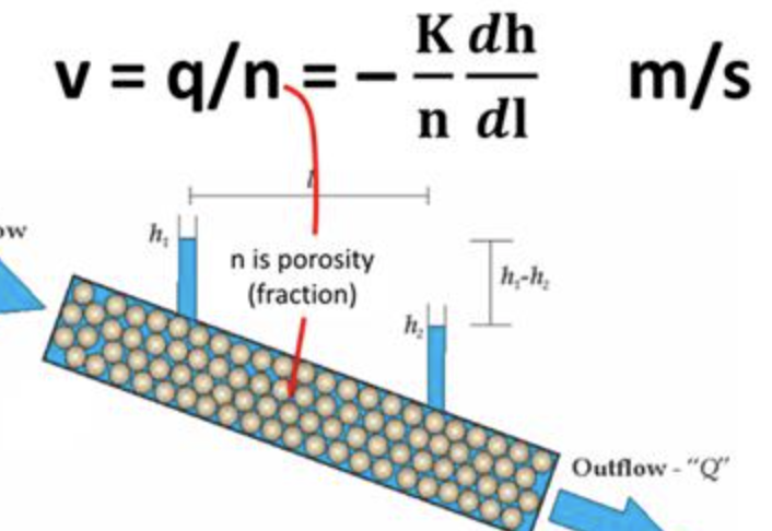
- 20aquifers are composed of different types of materials :sand aquifers
clay aquitards
sandstone aquifers
basalt aquifers
limestone karst aquifers
fractured granite aquifers - 21how are karst caves formed? what are some karst features?Rainwater picks up carbon dioxide from the air and as it percolates through the soil, which turns into a weak acid. This slowly dissolves out the limestone along the joints, bedding planes and fractures, some of which become enlarged enough to form caves
karst features : sinkhole and cenotes - 22Groundwater Movement in Streams: what are the 2 basic ways that groundwater moves?exchange of water between groundwater and streams depends on the positions of the water table with respect to the stream bed
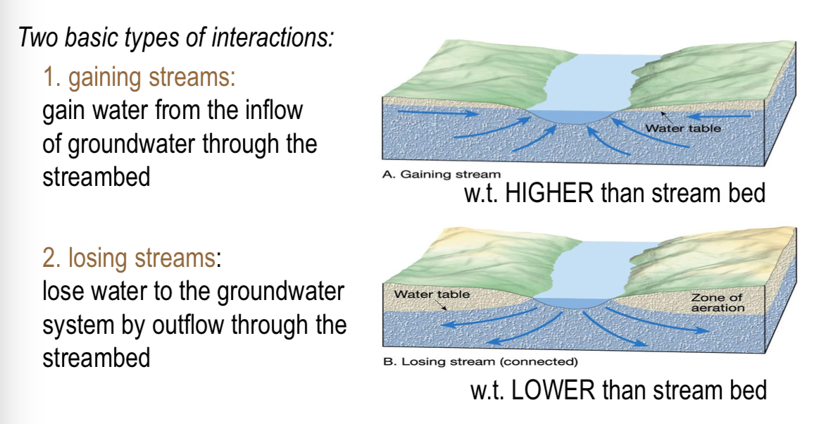
- 23What can over pumping of groundwater by wells cause?
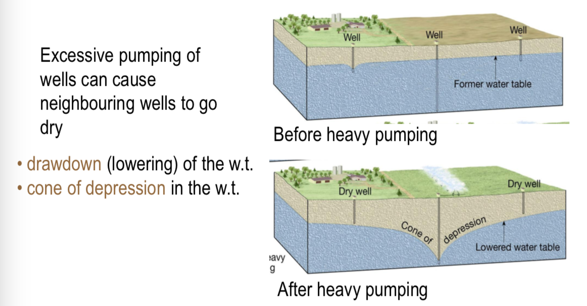
- 24What can over pumping of groundwater in coastal regions cause?
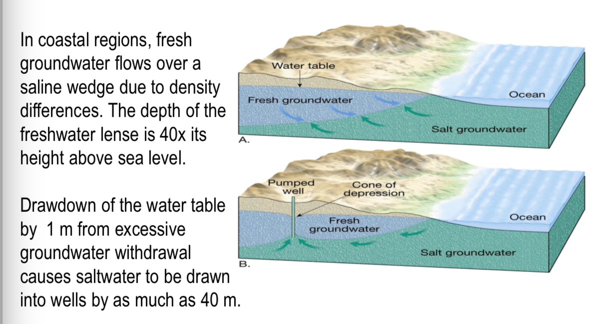
- 25Tracing Groundwater Recharge
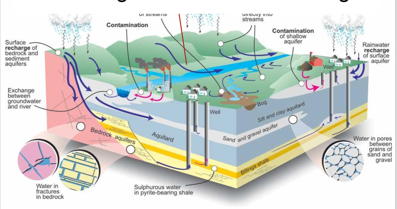
- 26Isotope Hydrologyfield of hydrology that uses isotopic dating to estimate the age and origins of water and of movement within the hydrologic cycle.
The techniques are used for water-use policy, mapping aquifers, conserving water supplies, and controlling pollution. - 27Isotopes that make up waterWater molecules carry unique fingerprints, based in part on differing proportions of the oxygen and hydrogen isotopes that constitute all water. Isotopes are forms of the same element that have variable numbers of neutrons in their nuclei.
Air, soil and water contain mostly oxygen 16 ( 16O). Oxygen 18 ( 18O) occurs in approximately one oxygen atom in every five hundred and is a bit heavier than oxygen 16, as it has two extra neutrons. - 28What minerals can be found in groundwater?Calcium (Ca), Magnesium (Mg),
Sodium (Na), Potassium (K),
Chloride (Cl), Bicarbonate (HCO3),
Sulfate (SO4) - 29How does biodegradation contribute to minerals in groundwater?When organics are biodegraded in soil, CO2 is produced
CO2 is then hydrated (combined with water) to create carbonic acid
the carbonic acid is then dissolved into groundwater, which can aid in the weathering of rocks in minerals - 30Carbonic acid and groundwater mineralizationin limestone weathering, carbonic acid found in the groundwater mixes with the calcium carbonate found in limestone.
this produces calcium and bicarbonate, which are minerals commonly found in groundwater
the carbonic acid can also react with dolomite (CaMg(CO3)2), which will produce calcium, bicarbonate and magnesium - 31What are some sources of groundwater contamination?> Nutrient pollution - caused by excess nitrogen and phosphorus in the air and water
> Agrochemicals - Biocides, herbicides, fungicides, rodenticides etc. They cause pollution when they reach wrong targets
> Fuels and solvents - can leak from storage facilities to contaminate groundwater and soils.
> industrial wastewater
>highway road salt
>bacteria and viruses - 32What are some of the main sources of nitrate?1) One large source of nitrogen pollution of groundwater is the application of nitrogen-rich fertilizers to turfgrass. This occurs on golf courses and in residential areas.
2) The main source of nitrate pollution in the groundwater results from the actions of farmers. The farmers first deplete the soil by "excessive, repeat planting" and then try to replenish the resulting less-productive soil by putting more and more nitrogen-based fertilizer on the land in an attempt to keep crop yields constant.
3) Another source of nitrate leaching to the groundwater is the storage of the manure. Farmers commonly store manure in large holes in the ground. While this is convenient for the farmer in the short term , it results in excessive leaching of nitrates
4) a non-anthropogenic source of nitrate is in the atmosphere. Atmospheric N2 is converted to nitrate (NO3-) by lightning.
5) Nitrate contamination can also be due to the septic systems - 33what are Organic non-aqueous phase liquids (NAPLs) ?hazardous organic liquids such as dry cleaning fluids, fuel oil, and gasoline that do not dissolve in water. A significant portion of contaminated soil and groundwater sites contain NAPLs, and they are particularly hard to remove from the water supply. NAPLs are always associated with human activity, and cause severe environmental and health hazards.
- 34How do NAPLs affect our groundwater?NAPLs can be more or less dense than groundwater, but can be soluble.
they will sit on or below the water table, and contaminate groundwaters for hundreds of years - 35what is Natural Source Zone Depletion (NSZD) and explain the processAfter a release into the environment, NAPLs go through various different degradation processes including dissolution, volatilization, and biodegradation.
NSZD is a term used to describe these processes that result in mass losses of NAPLs from the subsurface.
NSZD processes occur naturally within NAPL-impacted zones in the subsurface.
These processes physically degrade the NAPLs by mass transfer of chemical components to the aqueous and gaseous phases where they are biologically broken down by anaerobic and aerobic biodegradation.
These processes produce soluble byproducts such as ferrous iron, dissolved methane (CH4), and carbon dioxide (CO2). - 36Examples of how aquitards can be used as barriers to contaminants
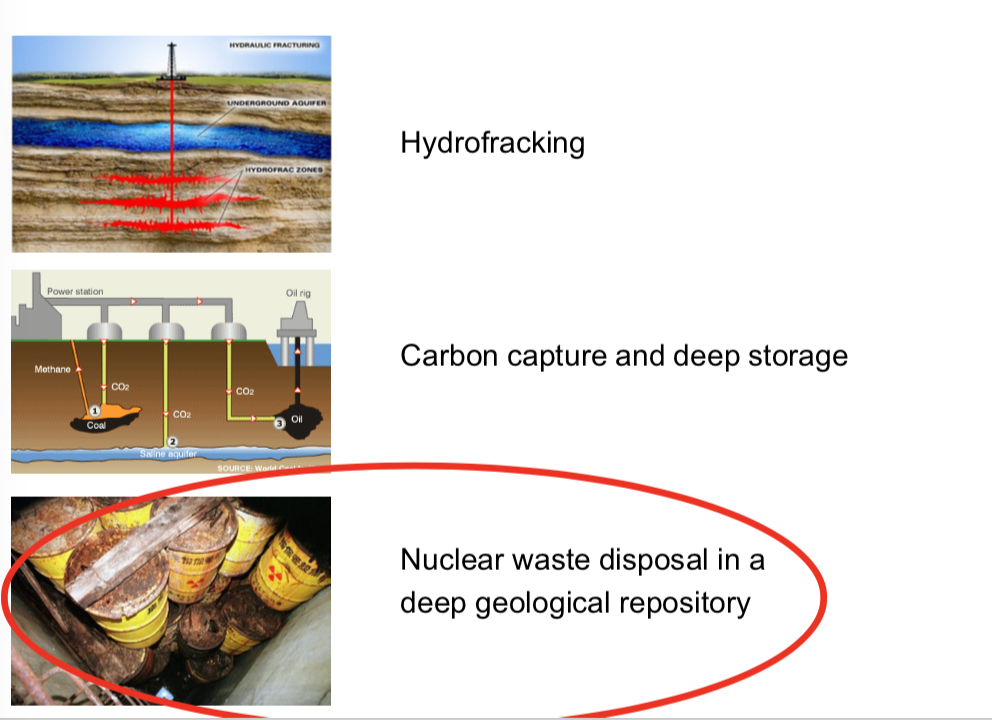
Informationen
- Beschreibung
- Der Nutzer hat seine Fachbereichs-Information gelöscht. Karteikarten am Earth Systems - FINAL - Hydrogeology , erstellt von Gelöschter Nutzer am 12/04/2018.
- Erstellt von
- Gelöschter Nutzer · Apr 2018
- Aktualisiert
- 12 Apr 2018
- Aufrufe
- 17
- Verlauf
-
- Erstellt von abby Radske · 1 Apr 2018
- Kopiert von abby Radske · 12 Apr 2018
- Bewertung