
Flussdiagramm
Lecture 3
Inhalt des Flussdiagramms
Emergence of ocean basins
we used to be one big continent = continetal dift first established in 1858, antonio snider-pellegrini, noted similiar foosils also 1831-1914 edward suess seen fern fossils present acorss all southern continents
supercontinent - gondwana and tethys ocean
land briges between continents.
edward - tries to explain oceans via cooling and sinking of materials with diff densities
Alfred wgeener 1880-1930
matches continents at 200m isobath - proposes continental drift
theory largely reject - lack mechanism
evidence - plant fossils
-animal fossils
-geological formations such as coal bed
- Paleoclimatological evidence from glacial deposits - s gondwana
emergence of plate tectonics - continental drift evidence
-formation of mountain range via compression & folding
-Collision between plate throws up mountian ranges
- Rift valleys and transform fualts consistent with tension from sea floor spreading
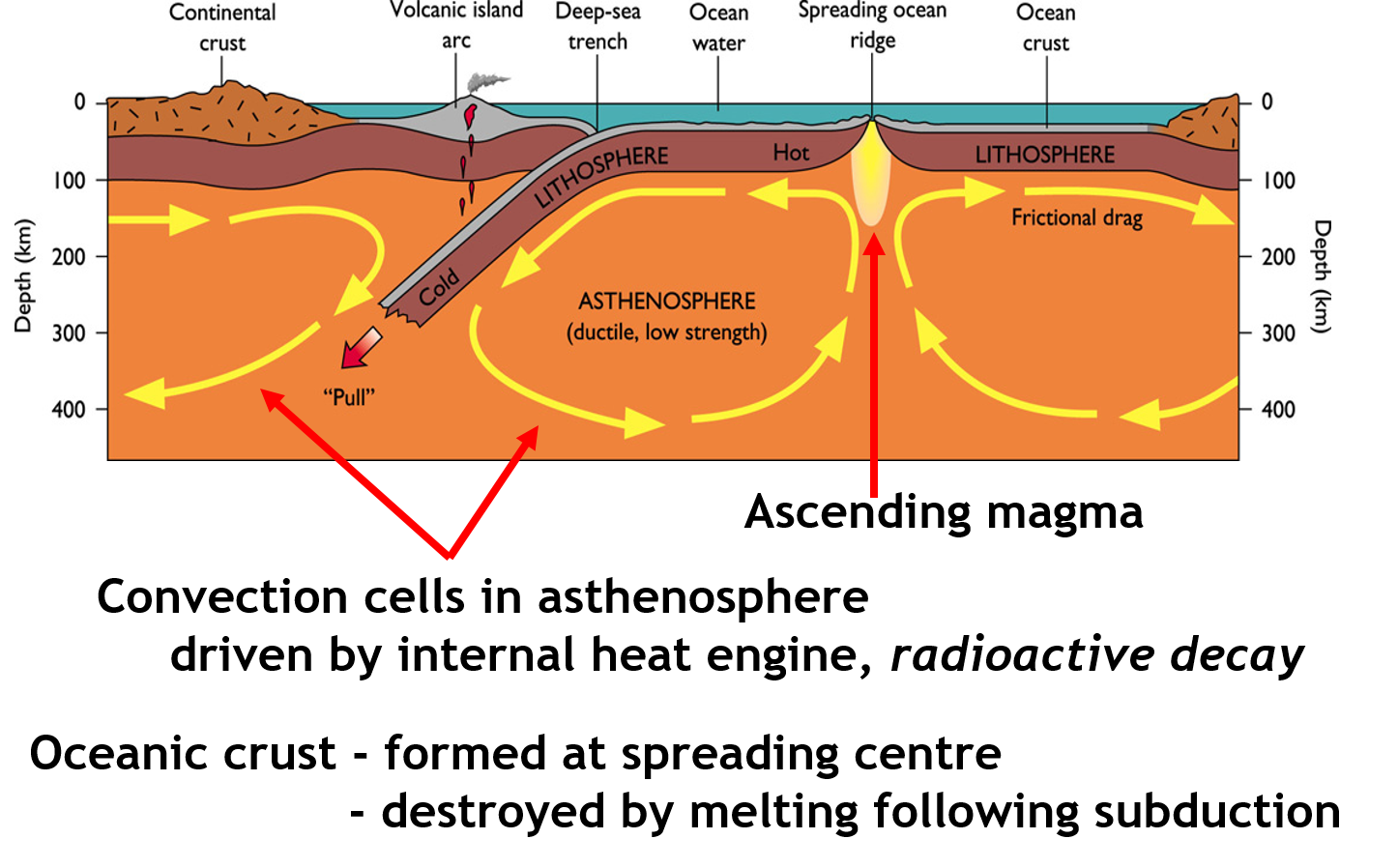
crustal motion
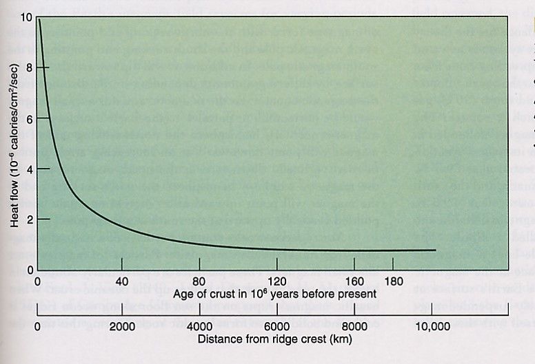
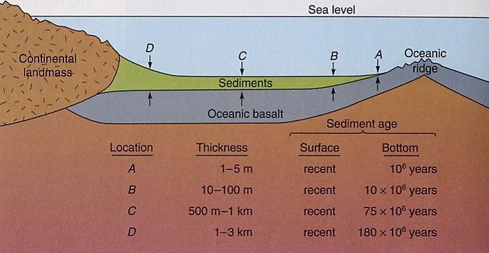
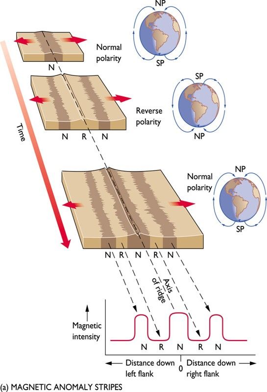
Four key observations
Geographical location of earth quakes - epicentres show plate boundaries
Geographical variability of crustal heat flow - decreases away from spreading centre
Geographical variability of thickness of deep-sea sediment - thickness increases away from spreading centre
Magnetic anomalies- orientation reverses - shows regular patterns away from spreading centre
Seismic Earthquakes are
concentrated
•Oceanic ridges
•Transform faults
•Trenches
•Island Arcs
Earthquake
magnitude
•Highest
at trenches- compression
•Lowest
at ridges- spreading
Geomagnetism
the earths magnetic field reverses approx. every 0.1 to 1 Ma
this is seen in basaltic rocks - solidified magma from volcanic eruptions - they are ricj in iron = ferromagnetic material - retains orientation od magnetic field upon cooliing - terrestrial rcords also document the reverse
Vine-matthews-morley Hypothesis
Independently developed in the 60- hypothesis
-new ocean crust formed at ocean ridgea
-magnetic orientation preserved
- magnetometer records should reveal magnetic anomalies - magnetic orientation should show striped pattern parallel to ridges
volcanic chains
oceanic crust moves over hot spot = hawian chain - youngest is the most active - oldest is subside. - subsudence and erosion eventually turn islands into guyots - emperor seamount chain
pacific ring of fire
Earths most active volcanoes driven by friction associated with convergence/subduction
these are common ocean-ocean convergence
Informationen
- Beschreibung
- Der Nutzer hat seine Fachbereichs-Information gelöscht. Flussdiagramm am Lecture 3 , erstellt von Gelöschter Nutzer am 10/05/2018.
- Erstellt von
- Gelöschter Nutzer · Mai 2018
- Aktualisiert
- 10 Mai 2018
- Aufrufe
- 19
- Verlauf
-
- Erstellt von chloe allen · 28 Mai 2017
- Kopiert von PAK LAM WONG · 10 Mai 2018
- Bewertung