
Quiz
[Notes Test] Civics 4 - July Exam (L1 - L4 Directions)
Dieses Quiz hat ein Zeitlimit und öffnet sich deshalb im gewohnten Player.
Fragen in diesem Quiz (11)
1Lesson 1.1: Earth
• E[blank_start]arth[blank_end] – man’s home in space
• Ob[blank_start]late[blank_end] sphe[blank_start]roid[blank_end] – shape of the earth, bulges in the middle, flattens on top and bottom
• Fer[blank_start]di[blank_end]nand Ma[blank_start]ge[blank_end]llan – proved the earth is NOT flat
• Era[blank_start]tos[blank_end]the[blank_start]ne[blank_end]s – calculated the size of the earth
• 2[blank_start]5[blank_end]000 KM – earth’s circumference
• 1[blank_start]5[blank_end]0 million km – earth’s distance from the sun
• O[blank_start]cea[blank_end]n – biggest water form, controls the h[blank_start]ot[blank_end]ness and coolness of earth’s surface temperature
• Con[blank_start]tinen[blank_end]ts – big masses of land
• At[blank_start]mosphe[blank_end]re – gases mixture protecting living things from sunlight’s harmful ra[blank_start]dia[blank_end]tion, by holding some of the sun’s w[blank_start]arm[blank_end]th.- Alate
- Broid
- Cge
- Ddi
- Etos
- Fne
- G5
- H5
- Icea
- Jot
- Ktinen
- Lmosphe
- Mdia
- Narm
- Oarth
2Lesson 1.1: Earth
Earth Parts:
1. L[blank_start]and[blank_end] = ¼
2. W[blank_start]ater[blank_end] = ¾
3. At[blank_start]mosphe[blank_end]re
Oceans:
1. Pa[blank_start]cifi[blank_end]c Ocean
2. In[blank_start]dia[blank_end]n ocean
3. At[blank_start]lan[blank_end]tic Ocean
4. A[blank_start]rc[blank_end]tic Ocean
5. An[blank_start]tarc[blank_end]tic Ocean
6. Sou[blank_start]the[blank_end]rn Ocean
Continents:
1. A[blank_start]si[blank_end]a – biggest continent
2. Aus[blank_start]tra[blank_end]lia - smallest
3. An[blank_start]tarc[blank_end]tica – snow covered
4. Af[blank_start]ri[blank_end]ca
5. North A[blank_start]meri[blank_end]ca
6. S[blank_start]ou[blank_end]th America
7. Eu[blank_start]rop[blank_end]e
5 layers of atmosphere (from the bottom):
1. Tro[blank_start]pos[blank_end]phere
2. S[blank_start]tra[blank_end]tosphere
3. Me[blank_start]sos[blank_end]phere
4. Ther[blank_start]mos[blank_end]phere
5. E[blank_start]xos[blank_end]phere- Aand
- Bater
- Cmosphe
- Dcifi
- Edia
- Flan
- Grc
- Htarc
- Ithe
- Jsi
- Ktra
- Ltarc
- Mri
- Nmeri
- Oou
- Prop
- Qpos
- Rtra
- Ssos
- Tmos
- Uxos
3Lesson 1.1: Label the 5 layers of the atmosphere
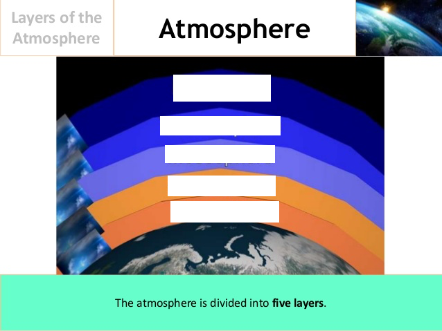
- Atroposphere
- Bstratosphere
- Cmesosphere
- Dthermosphere
- Eexosphere
4Lesson 1.2 - Globe
• Gl[blank_start]obe[blank_end] – closest representation of earth
• Deg[blank_start]ree[blank_end]s – unit of measure of distance between lines on the globe
Globe Imaginary Lines:
1. M[blank_start]eri[blank_end]dians – vertical lines, meet at the poles
2. Pa[blank_start]ralle[blank_end]ls – ho[blank_start]rizon[blank_end]tal lines, run in east-west direction, around the globe
3. E[blank_start]qua[blank_end]tor – globe imaginary line in the middle, east to west, dividing the globe into 2 equal parts: n[blank_start]ort[blank_end]hern and s[blank_start]out[blank_end]hern hemispheres
4. P[blank_start]rim[blank_end]e Me[blank_start]ridi[blank_end]an – also called ze[blank_start]ro[blank_end] meridian, runs from north to south of the globe, diving the globe into E[blank_start]ast[blank_end]ern and w[blank_start]est[blank_end]ern Hemispheres
5. Inter[blank_start]nationa[blank_end]l Da[blank_start]te[blank_end] Li[blank_start]ne[blank_end] (IDL) – meridian where date and day chan[blank_start]ge[blank_end]s, boundary between eastern and western hemispheres, places on the e[blank_start]as[blank_end]t are day behind places in the w[blank_start]es[blank_end]t
6. Gr[blank_start]id[blank_end] – formed when lines of latitude and longitude met or put together- Aeri
- Bralle
- Crizon
- Dqua
- Erim
- Fridi
- Gort
- Hout
- Iast
- Jest
- Knationa
- Lte
- Mne
- Nree
- Oobe
- Pro
- Qas
- Res
- Sge
- Tid
5Lesson 1.2: Label the Imaginary Lines
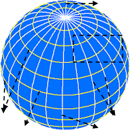
- Aprime meridian
- Binternational date line
- Cparallels
- Dequator
- Emeridians
- Fgrid
6Lesson 1.2: Globe
Distance Measurement:
1. La[blank_start]titu[blank_end]de – distance between two parallels, north or south of equa[blank_start]tor[blank_end]
2. Lo[blank_start]ngitu[blank_end]de –distance between two meridians, east or west of prime meri[blank_start]dian[blank_end]
Earth’s Sun Rays Zone:
1. Tro[blank_start]pica[blank_end]l Zone – near the equator, receives vertical rays of the sun
2. Tem[blank_start]pera[blank_end]te Zone – receive oblique rays of the sun
Northern Hemispheres Tropics:
1. Tropic of Can[blank_start]cer[blank_end] = Tropical Zone + Temperate Zone
2. A[blank_start]rc[blank_end]tic Circle – where temperate zone ends in the northern hemisphere, near the north pole
Southern Hemispheres Tropics:
1. Tropic of Capri[blank_start]corn[blank_end] – tropical zone + temperate zone
2. An[blank_start]tarc[blank_end]tic Circle – where temperate zone ends in the southern hemisphere, near the south pole- Angitu
- Brc
- Ctarc
- Dtitu
- Etor
- Fdian
- Gpica
- Hpera
- Icer
- Jcorn
7Lesson 1.2: Label the Tropics of the Earth (the part that receives vertical and oblique rays of sun)
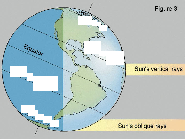
- AArctic Circle
- BTropic of Cancer
- CTropic of Capricorn
- DAntarctic Circle
8Lesson 1.3 - Maps
Lesson 1.3 - MAPS
• Map - is a fl[blank_start]at[blank_end] representation of a place
• Purpose of Map - helps a person r[blank_start]ea[blank_end]ch his des[blank_start]tina[blank_end]tion
• Car[blank_start]togra[blank_end]phy - called for mapmaking
• Carto[blank_start]grapher[blank_end]s - expert map makers
• Sy[blank_start]mbo[blank_end]ls - refers to the legend used on a map
KINDS of Map:
1. Po[blank_start]litica[blank_end]l Map - national boundaries, different provinces, and major cities
2. Phy[blank_start]sica[blank_end]l Map - physical features of earth; mountains, volcanoes, valleys, etc.
3. Eco[blank_start]nomi[blank_end]c Map - where natural resources abound - products, major industries
4. Po[blank_start]pula[blank_end]tion Map - distribution pattern and population
5. Eth[blank_start]nic[blank_end] Map - languages, cultural orientation, religions
6. Co[blank_start]mmu[blank_end]nity Map - establishments of buildings, harbors, services and sources of power for industries being developed
7. Cli[blank_start]mat[blank_end]e Map - how climate and weather conditions vary- Aat
- Btina
- Cea
- Dtogra
- Egrapher
- Fmbo
- Glitica
- Hsica
- Inomi
- Jpula
- Knic
- Lmmu
- Mmat
9Lesson 1.3 - Maps
Map Elements:
1. Ti[blank_start]tl[blank_end]e - tells the kind of the map
2. Le[blank_start]gen[blank_end]d - explains the map symbols
3. S[blank_start]cal[blank_end]e - shows the map distance and actual earth distance proportion/ratio
4. Di[blank_start]rec[blank_end]tion - orients to different points; north, south, east & west
5. La[blank_start]tit[blank_end]ude/Long[blank_start]itu[blank_end]de - gives the place absolute location.
Map Symbols:
1. M[blank_start]ai[blank_end]n road
2. R[blank_start]ai[blank_end]l Road
3. Ri[blank_start]ve[blank_end]r
4. R[blank_start]ic[blank_end]e Field
5. Ch[blank_start]urc[blank_end]h
6. Ca[blank_start]pi[blank_end]tal
7. Ca[blank_start]na[blank_end]l
8. Sc[blank_start]hoo[blank_end]l- Atl
- Bgen
- Ccal
- Drec
- Etit
- Fitu
- Gai
- Hai
- Iic
- Jurc
- Kpi
- Lna
- Mhoo
- Nve
10Lesson 1.4 Directions
• Direction - where one may fa[blank_start]ce[blank_end] or po[blank_start]in[blank_end]t, helps people loc[blank_start]at[blank_end]e places easily.
• No[blank_start]rt[blank_end]h A[blank_start]rro[blank_end]w - arrow pointing to the North, in a map
• C[blank_start]ompa[blank_end]ss - instrument with magnetic needle that points to the north
• Rela[blank_start]tiv[blank_end]e Location - the direction of a place in relation to another
• [blank_start]Ea[blank_end]st - sun rise
• [blank_start]We[blank_end]st - sun sets
Primary Directions:
1. N[blank_start]orth[blank_end]
2. S[blank_start]outh[blank_end]
3. E[blank_start]ast[blank_end]
4. W[blank_start]est[blank_end]
Secondary Directions:
1. no[blank_start]rthea[blank_end]st - between north and east
2. so[blank_start]uthea[blank_end]st - between south and east
3. no[blank_start]rthwe[blank_end]st - between north and west
4. so[blank_start]uthwe[blank_end]st - between south and west- Ace
- Brt
- Crro
- Dompa
- EEa
- FWe
- Gorth
- Houth
- Iast
- Jest
- Krthea
- Luthea
- Mrthwe
- Nuthwe
- Oat
- Pin
- Qtiv
11Lesson 1.4: Label the Primary and Secondary Directions
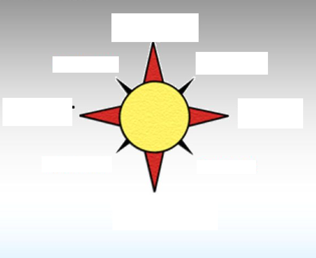
- ANorth
- BSouth
- CEast
- DWest
- ENortheast
- FNorthwest
- GSoutheast
- HSouthwest
Informationen
- Beschreibung
- Der Nutzer hat seine Fachbereichs-Information gelöscht. Quiz am [Notes Test] Civics 4 - July Exam (L1 - L4 Directions), erstellt von Gelöschter Nutzer am 18/07/2017.
- Autor
- Gelöschter Nutzer
- Sprache
- English
- Aufrufe
- 14
- Verlauf
- Erstellt am 18 Jul 2017 · aktualisiert am 18 Jul 2017
- Schlagwörter
- Bewertung
- Noch keine Bewertungen Bewerte dieses Quiz