
Notizen
Hazard Trends and Management
Inhalt der Notizen (9)
Seite 1
Tectonic Disaster Trends Since 1960
Tectonic hazards are something that can't be prevented. Despite increases in technology over the last 50 years, the risk to people, particularly those with low income, has increased. This increase is mainly due to human factors rather than physical factors.
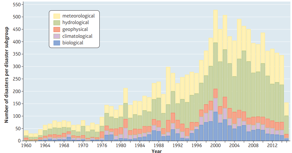
The total number of recorded hazards has also increased over the last 50 years.
The number of reported disasters seems to be falling, having peaked in the early 2000's.
The number of deaths has also decreased.
Natural disasters are more common in countries with a low and medium level of development. Many of these countries are in tropical areas which have monsoon rainfall or hurricanes. Disasters cause more death and disruption in poor countries, which lack the resources and funds to develop high-tech prevention and prediction systems. Damage in absolute economic terms remains highest in high-income countries but in relative terms it is much more devastating for poorer countries.
There isn't a universal definition for a disaster. Reporting disaster impacts, particularly deaths, is quite controversial for several reasons:
It depends on whether just direct deaths or indirect deaths from secondary effects are counted
Local or regional events in remote locations are often under-recorded
Declaration of disaster deaths and casualties may be subject to political bias
Statistics on major disasters are often difficult to collect, particularly in remote or less developed areas
Reports of hazards and disasters may be biased over time because there is now more reporting of events by the media
Time trend analysis (trends over time) can be difficult depending on the intervals
Seite 2
Tectonic Mega-Disasters
Mega-disasters are large-scale disasters on either an aerial/spatial scale or in terms of their economic/human impact.
Strong governance can lead to very effective management of immediate disaster recovery (e.g. Sichuan earthquake in China) as well as the development of longer-term education and community preparation strategies. However, management is expensive and with long return intervals there are strains on budgets that may affect levels of investment. Mega-disasters pose serious problems challenges for any governance, however well-planned, for example, the 2011 Japanese tsunami.
The scale of their impact means that communities and governments often need international support, both in the immediate aftermath of the disaster and during long-term recovery.
Tectonic mega-disasters are often classified as high-impact, low- probability (HILP) events. The consequences of HILP events spread rapidly across economic and geographic boundaries, creating other impacts that are difficult to plan for.
Seite 3
Multiple-Hazard Zones
Multiple-hazard zones are regions exposed to multiple natural hazards at the same time, increasing the risk to the area.
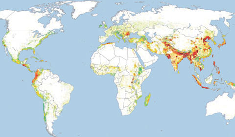
These areas are often more vulnerable because of repeated events and low levels of development. Places that experience repeated hazards and are not allowed to recover are called disaster hotspots.
The map below (taken from the United Nations study of global disaster risk) shows global disaster hotspots.
Seite 4
Predicting Natural Hazards
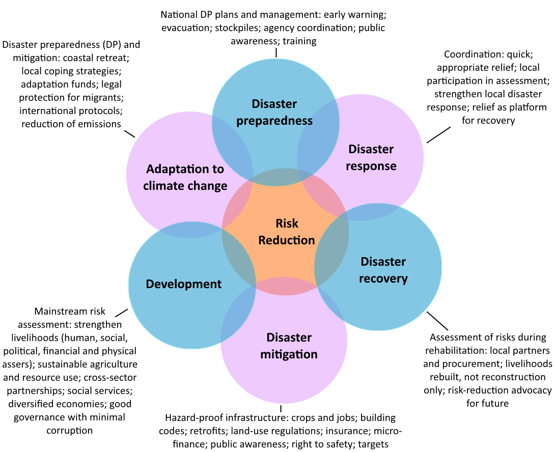
The Risk Disk (shown below) is a model to help better understand the reasons for the decline in deaths due to disaster preparedness, mitigation, response and recovery.
Predicting Volcanic Eruptions:
There are 700 active volcanoes on Earth, with about 50 erupting in any year. However, their locations are well known and as a volcano becomes active, it gives off a number of warning signs. These warning signs are picked up by volcanologists (experts who study volcanoes) and the volcano is monitored.
Many volcanoes are constantly monitored by Earth Scientists and geologists, working for organisations such as United States Geological Survey (USGS) and British Geological Survey (BGS). An estimated 500 million people are at risk from volcanic eruptions and vulnerability is increasing because the mineral resources (including fertile soils), tourist income, or geothermal energy attract people.
The precursors to eruptions include: harmonic tremors (small earthquakes created as the magma forces its way to the surface), gas and steam emissions or bulges in the crater or sides of the volcano (for example Mount St Helens 1980).
Earthquakes:
The prediction of earthquakes is a lot more complex. One useful predictive tool is estimating the build-up of stress and strain by using the time gaps between earthquakes; this was scientifically successful for Haiti in 2010 and Nepal in 2015. But this method still does not give the precise location or precise time of an event.
Engineers and scientists have important roles here in terms of making full use of technology to monitor and predict volcanoes and tsunamis, and attempts are still being made with earthquakes. GNS Science use satellite and aircraft remote sensing data, including LiDAR (Light Detection and Ranging) and synthetic aperture radar (or SAR), both of which create high resolution 3D data for the Earth’s surface in an attempt to predict earthquakes.
Radon gas often escapes from cracks in the Earth's crust before an earthquake. Levels of radon gas can be monitored - a sudden increase may suggest an earthquake.
Seite 5
The Hazard Management Cycle
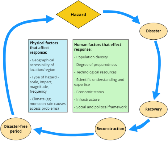
The hazard management cycle has several stages:
Disaster: the response to a disaster is an active measure of how a country or community reacts to events
Recovery: another active post-event measure in terms of the time it takes for recovery and action plans to be put in place
Reconstruction: pro-active strategies put in place before an event occurs to prevent a hazard from occurring
Disaster-free period: the time to prepare for the next disaster - preparedness is a pro-active method to help increase resilience to a future disaster
Seite 6
Park's Model (The Disaster Response Curve)
Park's Disaster Response Curve Model plots the quality of life after a disaster against the time after the disaster has occurred. The model usually shows the deterioration of the quality of life of the people affected and the speed at which the country returns to normality.
Park's Model is important as a way of developing an understanding of the way countries and communities affected by hazards are impacted over the full cycle of disaster and recovery.
Each stage on the x axis shows the different periods of time during which either relief, rehabilitation or reconstruction is started. The words on the y axis describe quality of life, stability and infrastructure.
Stage 1: Pre-disaster
Quality of life is normal
People do their best to plan and prepare for disasters happening by educating the public on how to act when there is a disaster
Supplies are prepared
Stage 2: Relief
The hazard event has occurred
Immediate relief includes medical attention and rescue services
This period can last hours to days
The quality of life stops decreasing and begins to move up slowly
Stage 3: Rehabilitation
Groups try to return the state of things back to normal by providing food, water and shelter to those who need it
Stage 4: Reconstruction
Reconstruction of infrastructure, crops and property
Movement towards prevention and preparation for the next disaster

Seite 7
Modifying a Hazard Event
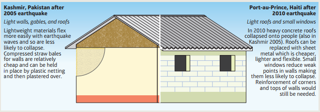
Modifying tectonic events is difficult because the forces are very powerful, and it is not possible to modify earthquakes because the place and time cannot be predicted.
Micro protection: strengthening individual buildings and structures against hazardous stress
Macro protection: large-scale protective measures designed to protect whole communities
Earthquakes:
Buildings can be designed to be aseismic or earthquake-resistant. There are three main ways of doing this:
putting a large concrete weight on the top of a building which will move, with the aid of a computer program, in the opposite direction to the force of the earthquake to counteract stress
building large rubber shock absorbers into the foundations to allow some movement in the building
adding cross-bracing to the structure to hold it together when it shakes
Tsunamis:
Planting mangroves on the coastline as a buffer can help to reduce the effects of a tsunami.
Volcanoes:
Once the lava has started to flow, it is possible, in certain circumstances, to divert it from the built environment by:
digging trenches (Mt Etna, Sicily)
explosive activity (Mt Etna, 1983)
artificial barriers, which also protect against lahars (Hawaiian islands)
pouring water on the lava front (Haeimaey, Iceland, 1973)
Seite 8
Modifying Vulnerability and Resilience
Modifying vulnerability is where action could be most effective. This involves a number of approaches including:
prediction, forecasting and warnings
improvements in community preparedness
improve things such as land-use planning to reduce disaster risks
As noted previously, tectonic hazards can be extremely difficult to predict. Prediction can also be problematic as it can make people feel safer and lead to complacency and lack of preparation, and there may be confusion over information and announcements.
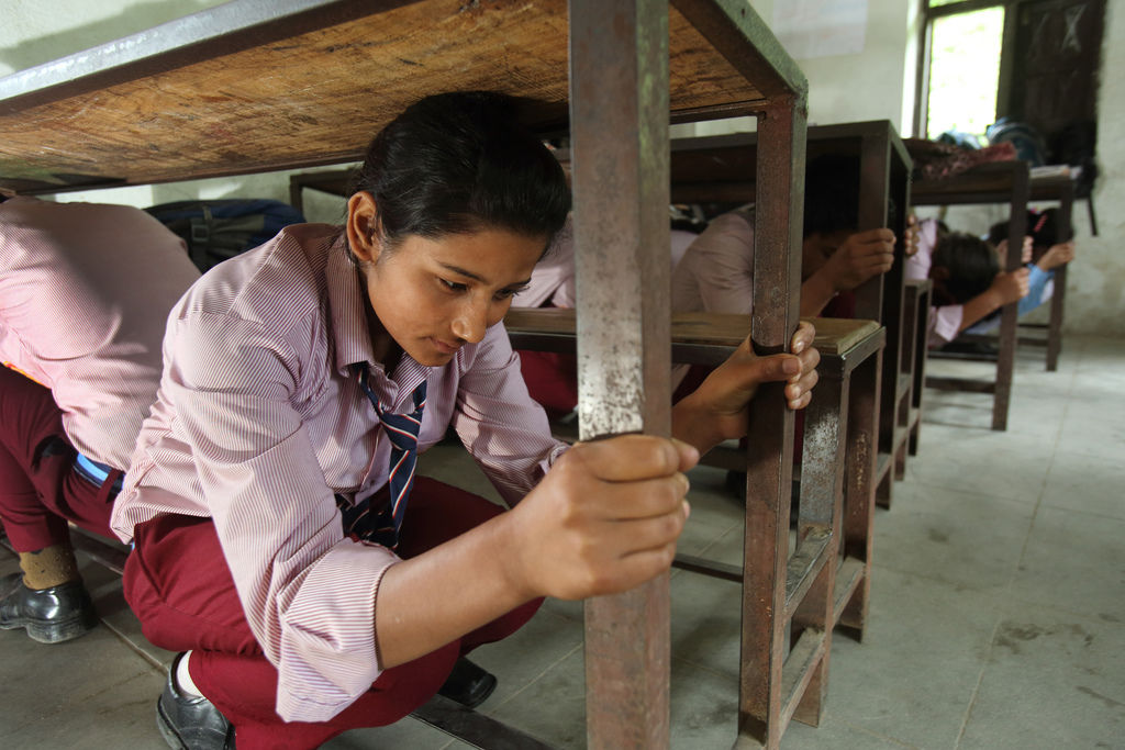
Investment in health care and education helps recovery and provides knowledge of what to do in an emergency, including practice drills and storing emergency supplies in public open spaces.
Schools, offices and factories in earthquake prone areas have earthquake ‘drills’. Government offices and many companies in Japan observe Disaster Prevention Day (1 September) which marks the anniversary of the Tokyo earthquake.
Improvements to communications routes, especially roads, make it easier to establish evacuation routes and help rescue efforts and the distribution of aid.
A new high-speed tsunami warning system (TWS) was established for Indonesia from 2008, enabling accurate warnings to be given via 11 regional centres across the country. There is a network of sirens, and a few evacuation centres with open ground floors to let water pass under.
Seite 9
Modifying Loss
Mitigation is about the modification of the loss burden after a disaster.
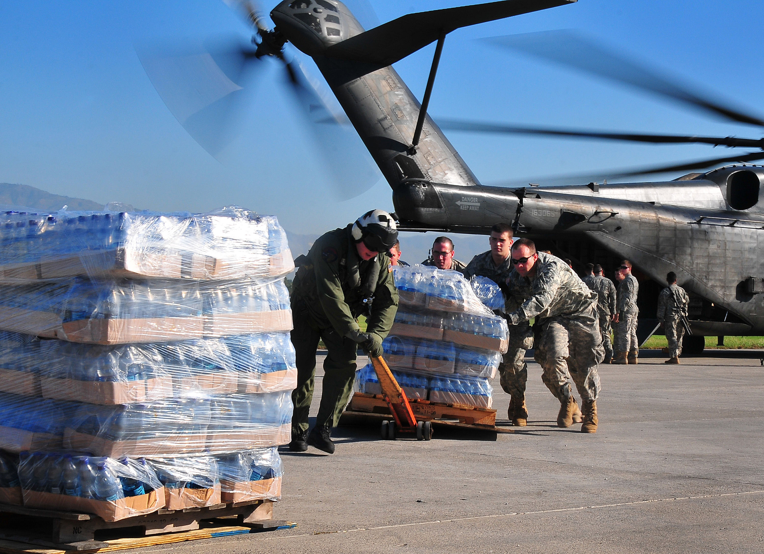
During and after a tectonic event the immediate response by the authorities is important. This includes fully equipped rescue efforts followed by relief aid (water, blankets, food, shelter, and sanitation) to prevent further deaths from exposure, hunger, thirst or disease.
Governments and NGOs may help with long-term reconstruction. Volunteers within affected communities are common, and where communications break down they are essential.
Some people may rely on insurance to recoup losses, including the growing trend of micro-insurance.
In some cases whole settlements may be moved away from risky areas and rebuilt in safer positions.
Informationen
- Beschreibung
- Der Nutzer hat seine Fachbereichs-Information gelöscht. Notiz am Hazard Trends and Management, erstellt von Gelöschter Nutzer am 09/08/2017.
- Erstellt von
- Gelöschter Nutzer · Aug 2017
- Aktualisiert
- 9 Aug 2017
- Aufrufe
- 89
- Verlauf
-
- Erstellt von Antonia Blankenberg · 3 Aug 2017
- Kopiert von Antonia Blankenberg · 9 Aug 2017
- Bewertung