
Notizen
Defining Glacial and Periglacial Landscapes
Inhalt der Notizen (11)
Seite 1
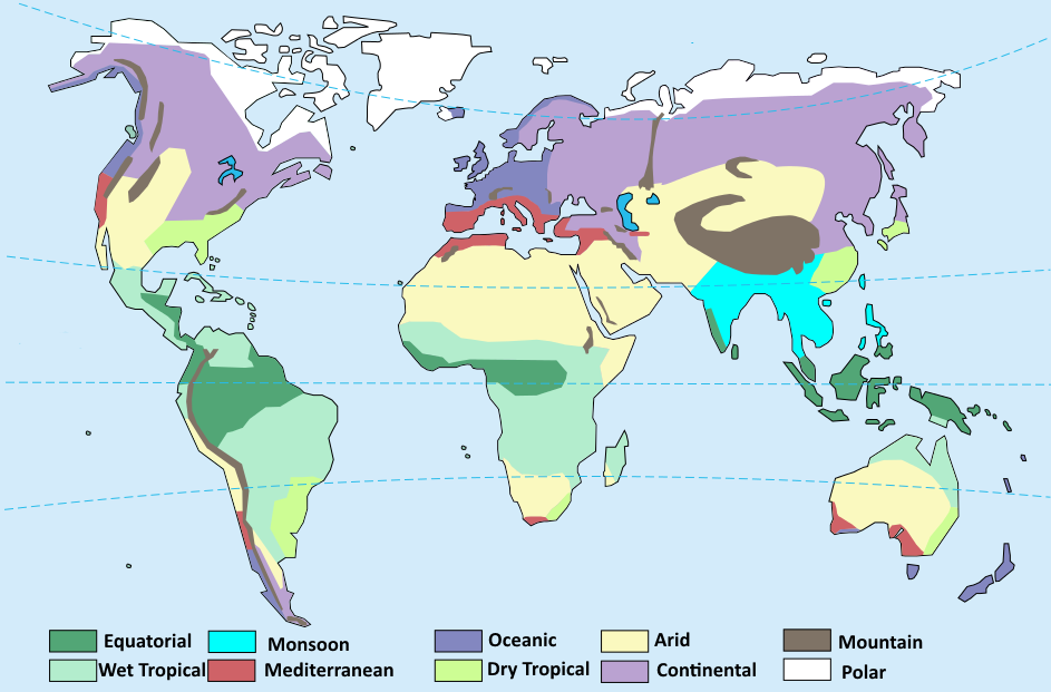
Cold Environments
Location:
Polar environments are found inland and far from the sea. Areas include: Greenland, Northern Canada, Northern Russia, and Antarctica.
Tundra environments are found to the south of the ice caps in the Northern hemisphere.
Cold environments cover approximately 20% of the Earth's surface.
Physical characteristics:
Tundra and polar environments experience very low temperatures.
Precipitation falls mostly as snow.
There is very little precipitation in polar regions as the cold air cannot hold much water vapour.
Tundra climates experience a thermal growing season that lasts approximately 6-10 weeks. During this time, the sun shines for 24 hours a day and temperatures are slightly warmer.
In cold climates, the ground is permanently frozen due to cold temperatures, this is called permafrost.
Biodiversity in these regions is low because it is difficult to survive the harsh conditions. Vegetation increases here where meltwater is available and soil depth is sufficient to support growth, this is common in periglacial regions.
Seite 2
Glacials and Interglacials
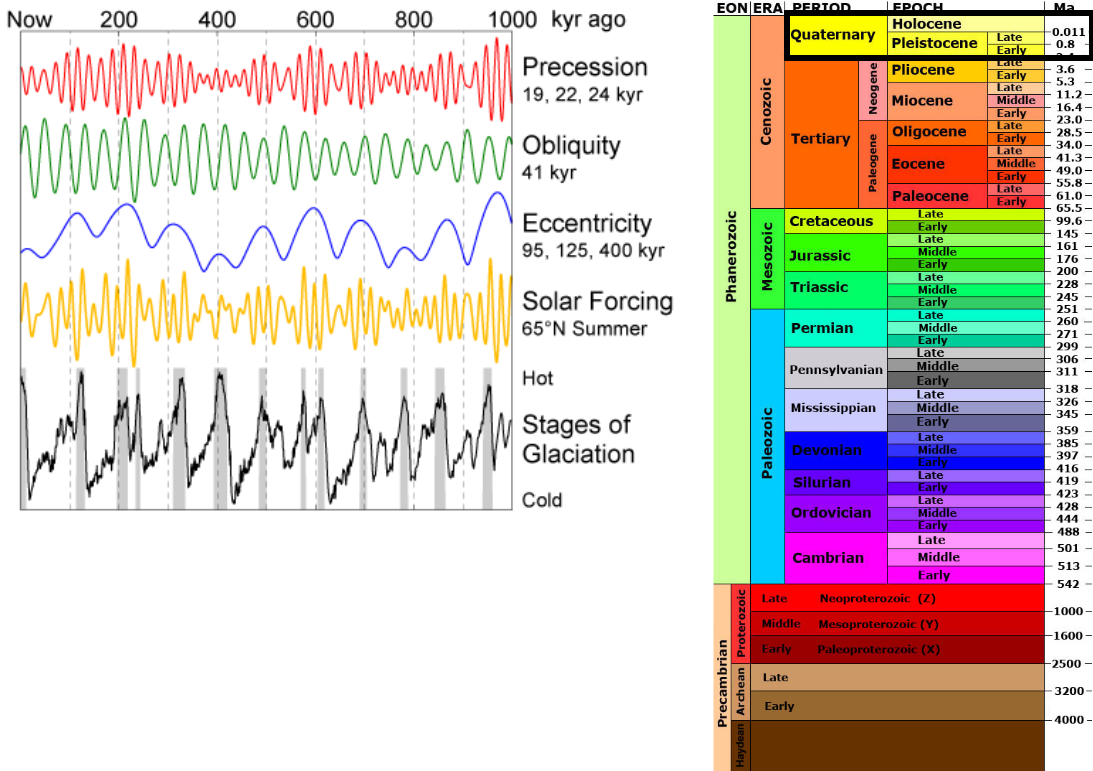
We are currently living in the Quaternary period. This period is split into two epochs of geological time; the Pleistocene and the Holocene. The Pleistocene epoch is defined by switches between glacial and interglacial conditions.
The Pleistocene covers from 2,500,000 to 11,700 years ago. The Holocene covers 11,700 years ago to the present day.
Research is done about glacials (cold periods) and interglacials (warm periods) by studying ice cores. Air bubbles that are trapped in glaciers contain a record of past climates by preserving oxygen isotopes. Low concentrations of carbon dioxide are found during glacial periods and high concentrations are found during interglacial periods.
On a geological time-scale, the Pleistocene can be considered as one long ice age, but realistically there were multiple cold periods throughout the epoch. These cold periods are also referred to as stadials or as having ice-house conditions.
The diagram on the left shows fluctuations between warm and cold climates, accompanied by the Milankovitch Cycles (explained on the next page). The table on the right shows the different geological periods over time, the numbers on the right showing millions of years ago (Ma).
Seite 3
Causes of Glacial/Interglacial Cycles
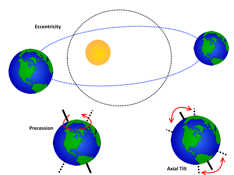
There are three different Milankovitch cycles which describe the orbital variations in the rotation of the Earth; eccentricity, precession, and axial tilt. Together, these cycles determine the amount of solar radiation each part of the world receives.
Eccentricity is the shape of the Earth's orbit around the sun. This ranges from nearly circular to elliptical and is caused by the gravitational pull of the other planets. A complete cycle of circular to elliptical and back to circular lasts 100,000 years. When the orbit is elliptical, winters are colder and summers are warmer.
Because the earth is not a perfect sphere, it wobbles on its axis, similar to a spinning top. This wobble is called precession and the Earth completes this cycle in 26,000 years. This cycle is caused by the gravitational pull of the moon. Seasons are impacted by this; summers can become warmer.
Axial Tilt is the angle at which the Earth's axis is pointed. This varies between approximately 21 degrees and 24 degrees over 41,000 years. A greater degree of tilt results in the Earth having a higher average temperature.
Seite 4
Causes of Short-Term Climate Fluctuations
Solar Variations:
The output of the sun can be measured by monitoring sunspots on the sun's surface, these are caused by magnetic activity on the sun.
Since the 1970's, a decrease can be seen in the output of the sun, meaning that the sun is not a cause for the current warming of the climate.
There was a reduction in sun spots recorded during the period of the "Little Ice Age", explaining the cooling at this time.
Volcanic Activity:
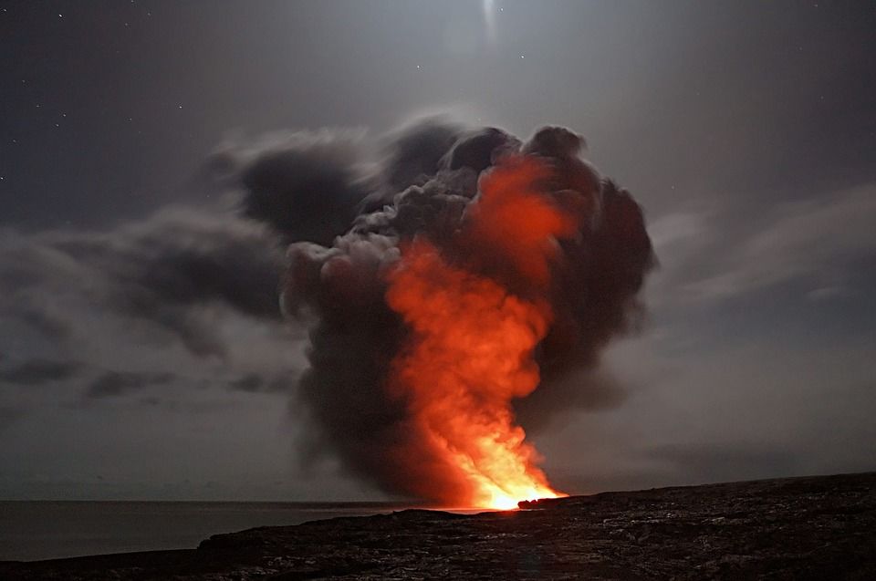
Volcanic eruptions can result in an altered climate.
Volcanoes with a high Volcanic Explosivity Index (VEI) can erupt large amounts of sulfur dioxide, which when mixed with water vapour, becomes a volcanic aerosol. This reflects sunlight away from the atmosphere and reduces the amount of solar radiation the Earth receives.
Although the carbon dioxide erupted from a volcano contributes to the greenhouse effect, the effect of the sulfur dioxide is often greater, meaning that the Earth will experience cooling.
The effect of sulfur dioxide will decrease over time with rainfall.
Seite 5
The Cryosphere
The cryosphere is the frozen water part of the Earth system.
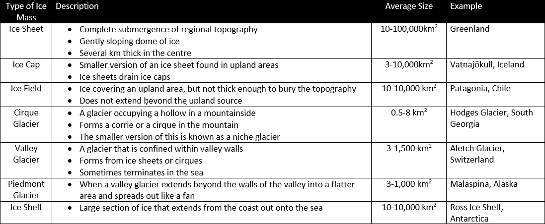
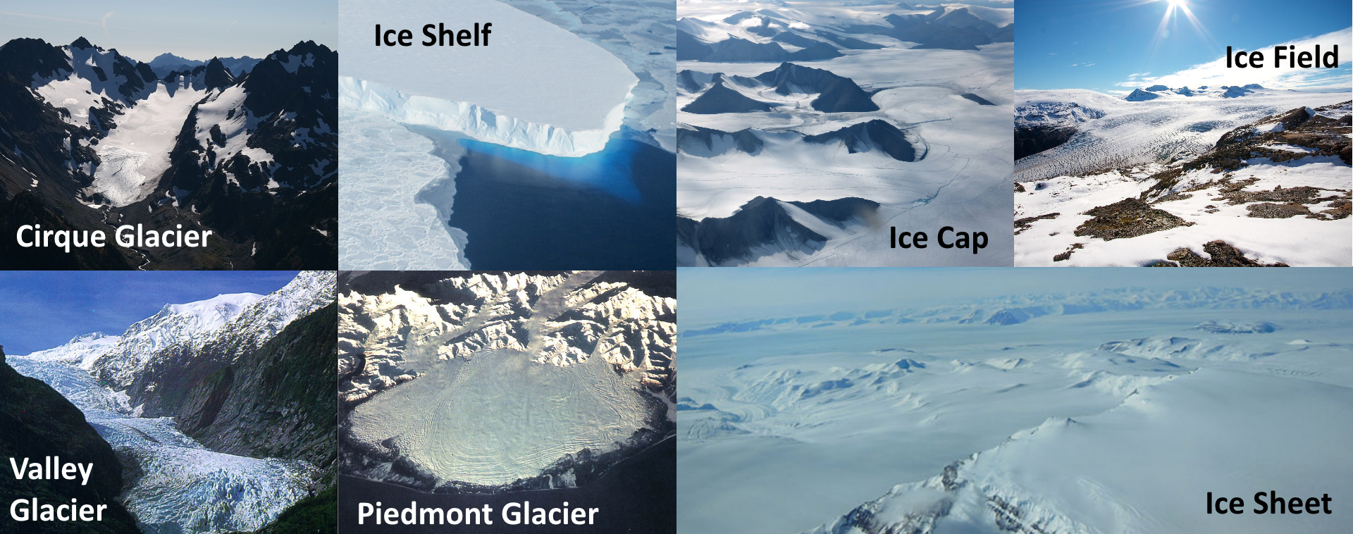
The cryosphere is made up of ice sheets, glaciers, sea ice, ground ice (permafrost) and snow cover.
Glaciers and ice sheets are sensitive barometers of climate change and can be classified by their morphology.
Glaciers can either be land based or sea based.
The thermal regime of the glacier determines how it moves.
Seite 6
Warm and Cold Based Glaciers
Warm Based (Temperate/Wet) Glaciers:
High altitude areas outside of the polar region
Temperature of the surface layer fluctuates above and below melting point depending on the time of year
Increased pressure causes water to remain a liquid below 0°C, causing the basal ice to melt continuously
The water acts as a lubricant so basal sliding can occur
As basal sliding can occur, warm based glaciers have a faster rate of movement than cold based glaciers and so carry out more erosion
Example: The Alps
Cold Based (Polar) Glaciers:
High altitude areas in the polar regions
Temperature of the surface ice is usually below 0°C and can be as low as -20 to -30°C
Relatively little surface melt
Permanently frozen to its bed
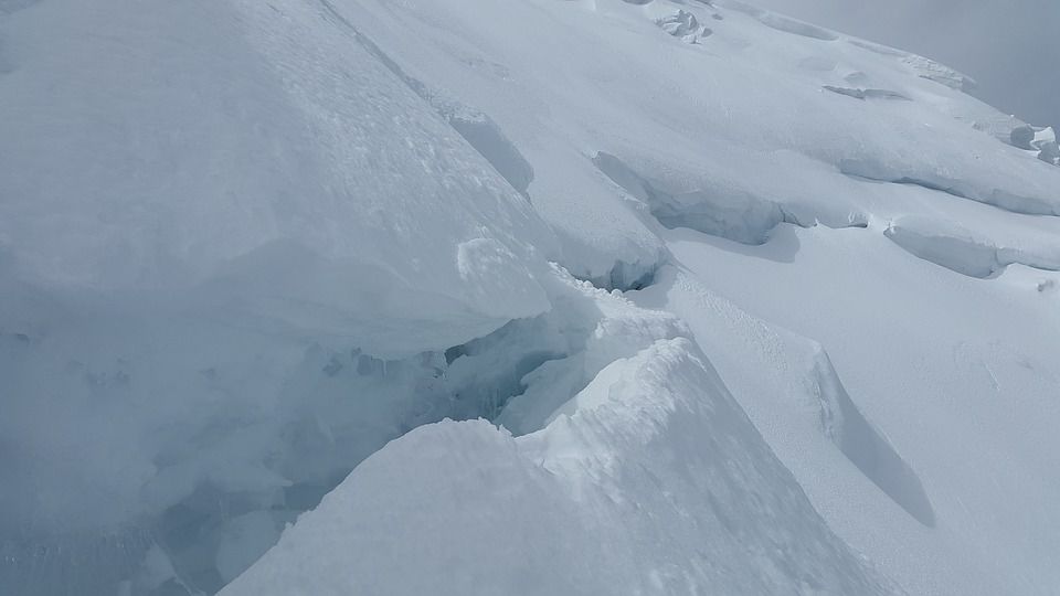
Tend to move via internal deformation as there is no water for basal sliding to occur - Internal deformation occurs when the weight of the ice causes the deformation of ice crystals.
Move slowly- causing less erosion to occur
Example: Antarctica and Greenland
Seite 7
Present Ice Cover
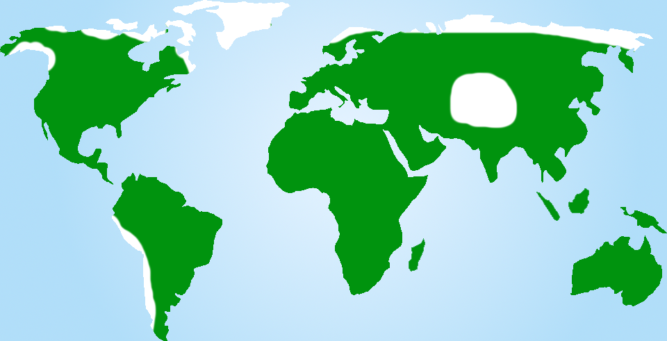
At present, glaciers cover approximately 10% of the Earth's land area, locking up about 75% of the Earth's freshwater.
85% of the glacial ice is contained in Antarctica. The 2nd largest ice deposit is the Greenland Ice Sheet.
The remaining ice is shared between ice caps in northern countries and in high altitude areas such as the Himalayas.
Latitude and altitude are the most important factors controlling the present distribution of ice. These factors control temperature and rainfall.
Seite 8
Ice Cover at the Last Glacial Maximum (LGM)
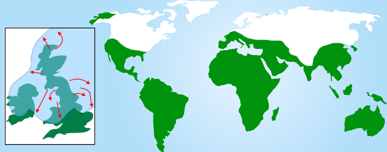
The Last Glacial Maximum (LGM) was the last period in the Earth's climate history during the last glacial period when ice sheets were at their greatest extension. This occurred approximately 26,000 years ago.
The ice cover at this time was over three times greater than it is today. Major areas that were covered include North America and Europe.
The arrows on the map below show the direction of ice movement in the UK.
Seite 9
Periglacial Environments
The word periglacial refers to an area adjacent to a glacier or ice sheet or otherwise subject to repeated freezing and thawing.
Periglacial climates have the following characteristics:
frost during winter and on snow-free ground during the summer
highest temperatures of -4°C to 1°C
average daily temperatures below 0°C for at least 9 months of the year
temperatures rarely rise above 18°C in the summer
low precipitation (<600mm)
fluctuating temperatures
Around 20% of the Earth's surface experiences periglacial conditions. This figure was approximately 33% during the LGM.
Permafrost
Approximately 25% of the Earth's surface experiences permafrost conditions.
Permafrost refers to soil and rock that remain frozen as long as temperatures don't exceed 0°C in the summer months for at least two consecutive years.
The distribution of permafrost environments is mainly controlled by climate.
On a local scale, there are several factors controlling permafrost:
Proximity to warm water bodies
Slope angle and orientation
Soil and geology
Vegetation cover
Snow cover
Seite 10
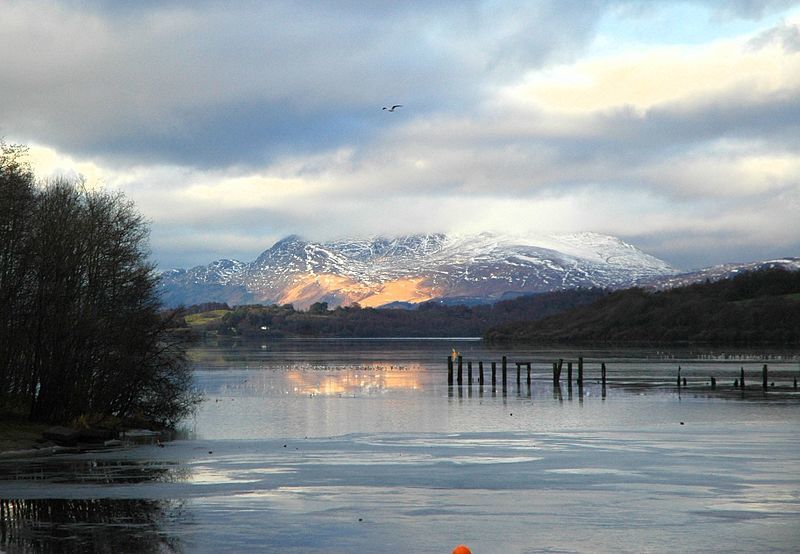
Loch Lomond Stadial
Ice sheets began to retreat from the UK approximately 18,000 years ago. This was because temperatures rose, causing the glaciers to melt.
Deciduous forest began to spread across Europe at this time.
However, 12,500 years ago, the temperatures plunged downwards, causing glacial conditions to return.
Glaciers re-advanced in many parts of the world, particularly the Scottish Highlands.
After this, temperature rose again rapidly (7°C in 50 years). This timing is considered to be inconsistent with orbital forcing and there were no large volcanic eruptions at this time, leading people to question what caused the temperature change.
It is thought that the Loch Lomond Stadial was triggered when drainage from the gigantic Lake Agassiz disrupted global ocean circulation, cutting off heat from the Gulf Stream.
Seite 11
The Little Ice Age
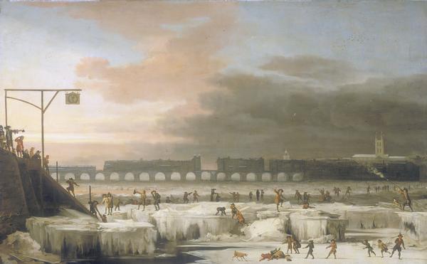
Historical documents and paintings are an important way to find out about past climate.
Between 1350 and 1900, conditions we slightly colder in the UK than usual.
Between 1550 and 1750, there were very cold conditions, known as the Little Ice Age, which occurred globally.
Many glaciers in Europe re-advanced down valleys.
Arctic Sea ice spread further south, with polar bears seen frequently in Iceland.
Rivers in the UK and lowland Europe froze over.
Curling developed as a national spot in Scotland because of the abundance of ice.
Some researchers argue that the Little Ice Age could have developed into a stadial period, but was stopped by the onset of the Industrial Revolution. The release of carbon dioxide from coal burning triggered climate warming, stopping the cold period from developing.
Informationen
- Beschreibung
- Der Nutzer hat seine Fachbereichs-Information gelöscht. Notiz am Defining Glacial and Periglacial Landscapes, erstellt von Gelöschter Nutzer am 15/08/2017.
- Erstellt von
- Gelöschter Nutzer · Aug 2017
- Aktualisiert
- 15 Aug 2017
- Aufrufe
- 45
- Verlauf
-
- Erstellt von Antonia Blankenberg · 9 Aug 2017
- Kopiert von Antonia Blankenberg · 15 Aug 2017
- Bewertung