2479396
Descripción
Test por Sven Koberwitz, actualizado hace más de 1 año
|
|
Creado por Sven Koberwitz
hace alrededor de 9 años
|
|
Pregunta 1
Pregunta
Which is NOT a type of location-allocation problem type?
Respuesta
-
Minimize Impedance
-
Optimize Cost
-
Maximize Coverage
-
Minimize Facilities
Pregunta 2
Pregunta
costdf = e(λ * impedancedf)
This equation represents which impedance transformation in location-allocation?
Respuesta
-
Linear
-
Power
-
Exponential
-
None of the Above
Pregunta 3
Pregunta
In some location-allocation problems one must locate a new facility amongst existing, non competing facilities that provide the same service. These existing facilities are referred to as _____ in the model.
Respuesta
-
Candidate facilities
-
Required facilities
-
Competitor facilities
-
Chosen facilities
Pregunta 4
Pregunta
A Network Dataset is ideal but not required to run a location-allocation model.
Respuesta
- True
- False
Pregunta 5
Pregunta
Competitor facilities are specific to the maximize market share and target market share problem types.
Respuesta
- True
- False
Pregunta 6
Pregunta
The Huff Model is an established business tool used to describe the interaction between consumer and facility.
Respuesta
- True
- False
Pregunta 7
Pregunta
Which type of problem type can be used to locate candidate facilities that are near competitor facilities.
Respuesta
-
Minimize Impedance
-
Maximize Coverage
-
Minimize Facilities
-
Maximize Market Share
Pregunta 8
Pregunta
People or things that require a facility are termed
Respuesta
-
Candidate Facilities
-
Chosen Facilities
-
Demand Points
-
Competitor Facilities
Pregunta 9
Pregunta
There are at least two iterations within the Teitz and Bart Heuristic. The first iteration…
Respuesta
-
Assigns each demand point to its nearest chosen facility
-
Assigns the chosen facility as the required facility
-
Assigns the competitor facility as the chosen facility
-
Assigns the demand point class to the nearest competitor facility
Pregunta 10
Pregunta
Spatial Autocorrelation gives a measure of dispersion and how data is distributed
Respuesta
- True
- False
Pregunta 11
Pregunta
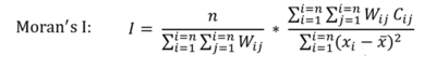
Moran’s I is based on a connectivity matrix and a proximity matrix
Respuesta
- True
- False
Pregunta 12
Pregunta
Rook’s method of determining adjacency used diagonal connectivity
Respuesta
- True
- False
Pregunta 13
Pregunta
All spatial autocorrelation measures are based on cross product statistics
Respuesta
- True
- False
Pregunta 14
Pregunta
Which is an alternative to Moran’s I?
Respuesta
-
Geary’s C
-
Anselin’s Local Moran’s I
-
all of the above
-
none of the above
Pregunta 15
Respuesta
-
proximity between cells
-
continuity between cells
-
number of cells
-
number of variables
Pregunta 16
Pregunta
After performing the Moran’s I calculation, you will have:
Respuesta
-
a measure of how the cells in a raster a related to one another
-
a proximity matrix
-
a continuity matrix
-
all of the above
Pregunta 17
Respuesta
-
A positive spatial autocorrelation
-
A negative spatial autocorrelation
-
A random spatial autocorrelation
-
None of the above
Pregunta 18
Pregunta
Who’s first law forms the basis of spatial autocorrelation?
Respuesta
-
Tobler
-
WAR
-
Price
-
Hill
Pregunta 19
Pregunta
What is one of the primary limitations of Moran’s I
Respuesta
-
It relies on too much hard math
-
It is not good for highly variable data
-
Not everyone plays chess and terms like rook, bishop, and queen are confusing
-
You need a super powerful computer to properly run the algorithm
Pregunta 20
Pregunta
The GRASS algorithm is an example of a probability analysis tool
Respuesta
- True
- False
Pregunta 21
Pregunta
Fuzzy Viewshed Tools return a raster of exclusively 1’s and 0’s
Respuesta
- True
- False
Pregunta 22
Pregunta
Intervisibility assumes that if an object is in the viewshed of a tower, the tower is also in that object’s viewshed.
Respuesta
- True
- False
Pregunta 23
Pregunta
The quality of a probability analysis improves with more input binary rasters.
Respuesta
- True
- False
Pregunta 24
Pregunta
The Following is NOT a type of Viewshed Analysis:
Respuesta
-
Binary
-
Fuzzy
-
Divergent
-
Probability
Pregunta 25
Pregunta
Which of the following fields does NOT use Viewshed:
Respuesta
-
Archaeology
-
Military Science
-
Urban Planning
-
Spelunking
Pregunta 26
Pregunta
What does a Probable Viewshed Analysis take into account?:
Respuesta
-
Variations in the DEM
-
Atmospheric conditions
-
Perspective
-
Probability of visibility of a given day
Pregunta 27
Pregunta
What does a Fuzzy Viewshed Analysis take into account?
Respuesta
-
Variations in the DEM
-
Atmospheric Conditions
-
Distances at which objects may be distinguished
-
Curvature of the Earth
Pregunta 28
Pregunta
Fuzzy Viewshed Analysis does NOT require this as an input:
Respuesta
-
Binary Viewshed Raster
-
Slope Raster
-
Euclidian Distance
-
Distance Decay Function
Pregunta 29
Pregunta
What is NOT a limitation of a Binary viewshed
Respuesta
-
DEM quality/resolution
-
Long Processing Time
-
Assumes Perfect Visibility
-
Raster Size
Pregunta 30
Pregunta
You are safe from tracking if you turn off the GPS in your phone.
Respuesta
- True
- False
Pregunta 31
Pregunta
The three techniques of using Wi-fi positioning system is cell identification and forward link
Respuesta
- True
- False
Pregunta 32
Pregunta
What are not the concerns of geotagging?
Respuesta
-
security threat
-
privacy concerns and security concerns
-
sharing data allows users to feel connected to others
Pregunta 33
Pregunta
What is not a way to geotag a location?
Respuesta
-
AGPS
-
Disposable film camera
-
Wi-fi positioning systems
Pregunta 34
Pregunta
We used FME Workbench to extract geotagged data as point?
Respuesta
- True
- False
Pregunta 35
Pregunta
The full power of ArcGIS can be used on extracted geotagged photos?
Respuesta
- True
- False
Pregunta 36
Pregunta
How accurate is the location information of geotagged photos?
Respuesta
-
30 - 40m
-
10 - 40 cm
-
10m - 20m
Pregunta 37
Pregunta
What tool was used to extract the points from the geotagged photos?
Respuesta
-
Jpeg GPS Point Replacer
-
GeoTagged Photos To Points
-
GeoTagging Image To Points
Pregunta 38
Pregunta
In AGPS which technique has the receiver still communicating with the satellites?
Respuesta
-
Mobile station assisted
-
Mobile station based
-
Mobile station helper
Pregunta 39
Pregunta
GeoServer is open source.
Respuesta
- True
- False
Pregunta 40
Pregunta
GeoServer is OGC compliant.
Respuesta
- True
- False
Pregunta 41
Pregunta
Secured Socket Layer utilizes port #443.
Respuesta
- True
- False
Pregunta 42
Pregunta
GeoServer can only be installed on a virtual server.
Respuesta
- True
- False
Pregunta 43
Pregunta
Which of the following ports are not neccessary for a PostGIS enabled database and GeoServer system?
Respuesta
-
22 (SSH)
-
80 (httpd)
-
5432 (postgresql)
-
8443(SSL)
-
110(POP3)
Pregunta 44
Pregunta
What is the Debian command that corresponds to Linux command-line command ‘yum’?
Respuesta
-
wget
-
rpm
-
sudo
-
apt-get
-
make
Pregunta 45
Pregunta
What file has to be modified to allow remote access to the PostgreSQL database?
Respuesta
-
pg_hba.conf
-
iptables
-
postgresql.conf
-
httpd.conf
-
workers.properties
Pregunta 46
Pregunta
Which one of the following formats can NOT be used with GeoServer?
Respuesta
-
KML
-
GML
-
SHP
-
GeoTIFF
-
MrSID
-
WAR
Pregunta 47
Pregunta
Which one of the following must be up and running before you install Tomcat?
Respuesta
-
Java Development Kit
-
GeoServer
-
Geospatial Engine
-
Geospatial Data Abstraction Library
-
PostgreSQL
-
All of the above
Pregunta 48
Pregunta
Which one of the following is not a strength of GeoServer?
Respuesta
-
Integrate with existing map APIs
-
Equipped with proprietary spatial engine
-
Compatible with popular GIS formats
-
Capable of tile caching
-
Customizable layout templates
Pregunta 49
Pregunta
Which is a source of error
Respuesta
-
Undershoot
-
Instrument Inaccuracy
-
Changes over time
-
All of the above
Pregunta 50
Pregunta
The accuracy of the Monte Carlo method is inversely related to the square root of the number of runs N?
Respuesta
- True
- False
Pregunta 51
Pregunta
What does ‘g’ represent in the following formula?
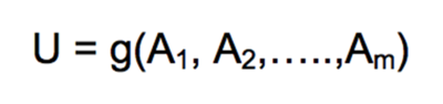
Respuesta
-
Output
-
Attribute
-
GIS operation
-
None of the above
Pregunta 52
Pregunta
Which error propagation technique is an approximation of things based on samples?
Respuesta
-
Taylor series approximation
-
Monte Carlo Method
-
Both a and b
-
None of the above
Pregunta 53
Pregunta
Uncertainty cascades through a sequence of operations in spatial GIS data
Respuesta
- True
- False
Pregunta 54
Pregunta
Error propagation can only be used once the input errors to the analysis are available
Respuesta
- True
- False
Pregunta 55
Pregunta
What is the most important thing to take into account when running a Monte Carlo method?
Respuesta
-
Randomly generated numbers
-
Approximation of the GIS operation
-
Numbers fall within 1 standard deviation from mean
-
All of the above
Pregunta 56
Pregunta
What is the aim of the Taylor series approximation method?
Respuesta
-
Identify various errors
-
Identify uncertainty sources
-
Identify source of error propagation
-
Both a and b
-
Both b and c
Pregunta 57
Pregunta
Which of the following is not a cause of errors in GIS
Respuesta
-
Collection
-
Classification
-
Digitization
-
Measurement
-
None of the above
Pregunta 58
Pregunta
When no record is kept of the accuracy of intermediate results, it become extremely difficult to evaluate the accuracy of the final results.
Respuesta
- True
- False
Pregunta 59
Pregunta
In Step 1 of Dijkstra’s algorithm, when setting tentative distances, the source node should be set to zero and all other nodes to infinity
Respuesta
- True
- False
Pregunta 60
Pregunta
The CCRP method is MORE ACCURATE that the linear programming algorithm
Respuesta
- True
- False
Pregunta 61
Pregunta
What is the name of the set.list created after the source node is set as "current"?
Respuesta
-
Unmarked Set
-
Unvisited Set
-
Unnamed Set
-
Network Set
-
None
Pregunta 62
Pregunta
Which of the following is NOT true of the Game Theory approach to Dijkstra’s algorithm?
Respuesta
-
finds the most efficient path
-
algorithms can handle unexpected events
-
can't be used for prediction
-
can account for congestion
Pregunta 63
Pregunta
What is the basic purpose of Dijkstra’s algorithm?
Respuesta
-
Create a buffer around a feature
-
calculate spatial stats
-
Generalize data
-
Find the shortest distance
-
None
Pregunta 64
Pregunta
During the algorithms calculation, each node in the network is continuously revisited
Respuesta
- True
- False
Pregunta 65
Pregunta
Dijkstra’s algorithm was formulated in 1956 and published in 1958
Respuesta
- True
- False
Pregunta 66
Pregunta
Which of the following are variants of Dijkstra’s algorithm?
Respuesta
-
Common
-
Priority Queue
-
Uniform cost search
-
All of the Above
Pregunta 67
Pregunta
Why can a game theory approach to routing provide better results for each traveller compared to a naive approach?
Respuesta
-
Every traveller takes other's choices into account
-
Making better use of the entire network
-
Not focussing on the shortest path only
-
All of the above
-
None of the above
Pregunta 68
Pregunta
What is a real life application of Game theory approach to routing?
Respuesta
-
provide a traveller with more than one route option
-
Evacuation planning
-
Find more scenic routes
-
All of the above
-
None of the above
Pregunta 69
Pregunta
R is an implementation of which language ?
Respuesta
-
C
-
Python
-
Greek
-
S
-
None of the above
Pregunta 70
Pregunta
R is best suited for
Respuesta
-
Statistical Analysis
-
Creating GUI’s
-
Plotting graphs and charts
-
A and C
-
Web mapping
Pregunta 71
Pregunta
Which package was used to read in a shapefile?
Respuesta
-
readShapePoly()
-
maptools
-
CoolTips
-
DPLYR
-
All of the above
Pregunta 72
Pregunta
Which R package provides the left_join() function?
Respuesta
-
dplyr
-
postgis
-
RStudio
-
maptools
Pregunta 73
Pregunta
Which publications is using R to create award winning data visualizations?
Respuesta
-
Der Spiegel
-
Washington Post
-
New York Times
-
None of the above
Pregunta 74
Pregunta
How many packages are available for R?
Respuesta
-
100
-
500
-
2000
-
Over 3000
Pregunta 75
Pregunta
R supports 3-Dimensional Arrays
Respuesta
- True
- False
Pregunta 76
Pregunta
You can use <= to assign variable values.
Respuesta
- True
- False
Pregunta 77
Pregunta
R can be run with single commands in the console.
Respuesta
- True
- False
Pregunta 78
Pregunta
One can implement Colorbrewer palettes within R.
Respuesta
- True
- False
Pregunta 79
Pregunta
The two main sections of Lidar data are Airborne and Terrestrial
Respuesta
- True
- False
Pregunta 80
Pregunta
All of these can process Lidar data except:
Respuesta
-
GRASS
-
ArcGIS
-
ENVI
-
GlobalMapper
-
None of the above
Pregunta 81
Pregunta
A user can import .las files from the “add data tool” in ArcMap
Respuesta
- True
- False
Pregunta 82
Pregunta
Which of the following is not included in the UG survey Lidar rules:
Respuesta
-
Collection Conditions
-
Data processing and Handling
-
Datums
-
Number of bands
-
Scope
Pregunta 83
Pregunta
Sources of uncertainty in extracting vector features from LIDAR data can be found in…
Respuesta
-
Complex structures
-
Reflective material types
-
Nearby Vegetation
-
All above
Pregunta 84
Pregunta
How many returns does a LIDAR pulse produce?
Respuesta
-
3
-
4
-
5
-
6
Pregunta 85
Pregunta
From the 31 classifications in the American Society for Photogrammetry and Remote Sensing, many of them are placeholders for future classifications
Respuesta
- True
- False
Pregunta 86
Pregunta
ArcToolbox in ArcGIS has a Change Vector Analysis tool.
Respuesta
- True
- False
Pregunta 87
Pregunta
CVA is a change detection technique that can be used on multispectral datasets.
Respuesta
- True
- False
Pregunta 88
Pregunta
Sector codes may be used to interpret what type of change is occurring.
Respuesta
- True
- False
Pregunta 89
Pregunta
The algorithms used within CVA are based on the Pythagorean Theorem and the cosine function.
Respuesta
- True
- False
Pregunta 90
Pregunta
Before CVA can be conducted, what needs to be done to the input images?
Respuesta
-
Geometric correction
-
Radiometric correction
-
Topographic Normalization
-
All of the above
Pregunta 91
Pregunta
What is a limitation of using CVA for change detection?
Respuesta
-
It can’t be used to detect change in multispectral datasets
-
It is difficult to determine threshold value
-
It produces poor results when applied to forestry applications
-
None of the above
Pregunta 92
Pregunta
Which of the following is not a common change detection technique?
Respuesta
-
Change Vector Analysis
-
Post-classification
-
Image differencing
-
Image multiplication
Pregunta 93
Pregunta
What datasets are appropriate for CVA?
Respuesta
-
Feature classes
-
Raster datasets
-
Tables
-
All of the above
Pregunta 94
Pregunta
Which of the following is an output of CVA?
Respuesta
-
Change direction
-
Change rotation
-
Change ratio
-
Change integration
Pregunta 95
Pregunta
If change magnitude = 0, what does this indicate?
Respuesta
-
NoData
-
At least one band has an input pixel DN value of 0
-
No change in DN value in at least one band
-
No change in DN value over all bands
Pregunta 96
Pregunta
What is NOT a method of calculating a Voronoi Diagram?
Respuesta
-
Fortunes Algorithm
-
Divide and Conquer
-
Construction Algorithm
-
Dijkstra’s Algorithm
Pregunta 97
Pregunta
When could you use a Voronoi Diagram?
Respuesta
-
To create a rainfall surface
-
To determine the nearest pub to BCIT
-
To determine paths of least resistance
-
All of the above
Pregunta 98
Pregunta
What method of Voronoi Diagram calculation is more time efficient?
Respuesta
-
Fortunes Algorithm
-
Divide and Conquer
-
Construction Algorithm
-
Dijkstra’s Algorithm
Pregunta 99
Pregunta
A Voronoi diagram divides the drawing into regions around each point that are shaped so that the borders of the regions are equidistant from the two nearest points.
Respuesta
- True
- False
Pregunta 100
Pregunta
Voronoi Diagrams first use was linked to Peter Gustav Lejeune Dirichlet in 1705
Respuesta
- True
- False
Pregunta 101
Pregunta
What is euclidean geometry?
Respuesta
-
a way of dividing space where objects in an area are more related to each other than the area that surrounds them
-
a type of analytic geometry, which uses coordinates
-
a type of synthetic geometry, which does not use coordinates
-
a way of dividing space where objects in that space are closer to the object it surrounds than any other object
-
Both A and B
-
Both C and D
Pregunta 102
Pregunta
A half-space is:
Respuesta
-
a closed space
-
a open or closed space
-
a concave space
-
one dimensional space
Pregunta 103
Pregunta
Convex polygons:
Respuesta
-
have internal angles greater than 180 degrees
-
are an open space with angles less than 180 degrees
-
are entirely contained, defined by each of its edges
-
can only be strict convex polygons
Pregunta 104
Pregunta
Sweep line algorithms can be used for generating Voronoi Diagrams
Respuesta
- True
- False
Pregunta 105
Pregunta
The point between three Voronoi points is a vertices or node
Respuesta
- True
- False
Pregunta 106
Pregunta
Which is NOT the type of geometries that form a multipatch?
Respuesta
-
Rings
-
Triangle Fans
-
Pyramids
-
Triangle Strips
Pregunta 107
Pregunta
ArcScene and ArcGlobe can be used display and analyse 3D models
Respuesta
- True
- False
Pregunta 108
Pregunta
Which tool is used for storing Multipatch data?
Respuesta
-
Intersect 3D
-
Add Z information
-
Line Of Sight
-
Layer 3D To Feature Class
Pregunta 109
Pregunta
ArcGIS does not have tools for applying Multipatch textures
Respuesta
- True
- False
Pregunta 110
Pregunta
Which of the following is not true?
Respuesta
-
Multipatch is a 3D geometry data type
-
Retain Multipatch textures by storing in a Geodatabase
-
Multipatch is viewable in 3D on ArcMap
-
Rings are 3D polygons defined by a bounded area
Pregunta 111
Pregunta
What is the data type of this structure? (0, 1, 2), (0, 2, 3), (0, 3, 4), (0, 4, 5)?
Respuesta
-
Triangle strips
-
Triangle fans
-
Rings
-
lines
Pregunta 112
Pregunta
5 points can form triangle-structured a multipatch
Respuesta
- True
- False
Pregunta 113
Pregunta
Inner ring-structure should be counter-clockwise direction
Respuesta
- True
- False
Pregunta 114
Pregunta
What feature class is needed for executing Intersect 3D analysis?
Respuesta
-
Multipatch
-
Polygon
-
Line
-
Point
Pregunta 115
Pregunta
What attributes can be added with Add Z Information tool?
Respuesta
-
Height values
-
Surface area
-
Volume
-
All of above
Pregunta 116
Pregunta
What data format is not recommended for
temporal Data?
Respuesta
-
Date
-
String
-
Double
-
Integer
Pregunta 117
Pregunta
A model that uses 12 layers representing Saskatchewan's monthly precipitation values in 2010 is an example of which data model?
Respuesta
-
Space-Time Composite
-
Snapshot
-
Event-Based Spatiotemporal Model
-
None of the above
Pregunta 118
Pregunta
What is the difference between real time and
near real time data?
Respuesta
-
Near real time data is slightly less accurate
-
Near real time data has a delay before imported into a GIS
-
A and B
-
None of the above
Pregunta 119
Pregunta
What toolbar is used to create Keyframes?
Respuesta
-
COGO
-
Raster Planning
-
Animation
-
Spatial Analyst
Pregunta 120
Pregunta
What needs to be enabled in order to use the Time Slider?
Respuesta
-
Symbology
-
Topology
-
Animation Tools
-
None of the Above
Pregunta 121
Pregunta
A model that uses 1 layer with a Date field
within the attributes is an example of which
data model.
Respuesta
-
Space-Time Composite
-
Snapshot
-
Event-Based Spatiotemporal Mode
-
None of the above
Pregunta 122
Pregunta
Event Based Spatiotemporal Data Model best
represents Vector Data.
Respuesta
- True
- False
Pregunta 123
Pregunta
The Snapshot Data Model, which timestamps
layers, has issues with data redundancy
Respuesta
- True
- False
Pregunta 124
Pregunta
ArcGIS has the ability to convert Strings into
Date field types
Respuesta
- True
- False
Pregunta 125
Pregunta
Weather Stations are a good example of
discrete temporal entity.
Respuesta
- True
- False
Pregunta 126
Pregunta
What is NOT an example of a fractal mathematical set?
Respuesta
-
Mandelbrot Set
-
Kalender Set
-
Koch Curve Set
-
Cantor Set
Pregunta 127
Pregunta
As the length of a measuring stick is scaled smaller, the measured perimeter of a coastline decreases
Respuesta
- True
- False
Pregunta 128
Pregunta
Benoit coined the term fractal
Respuesta
- True
- False
Pregunta 129
Pregunta
What does the diamond step of the diamond-square algorithm do?
Respuesta
-
Assigns a midpoint between the corner points
-
Assigns the first corner point
-
Assigns a mean value for the mid points
-
Assigns a center value for the square
Pregunta 130
Pregunta
What does the square step of the diamond square algorithm do?
Respuesta
-
Assigns a midpoint between the corner points
-
Assigns the first corner point
-
Assigns a mean value for the mid points
-
Assigns a center value for the square
Pregunta 131
Pregunta
In GRASS GIS, which of the following is NOT a parameter that can be specified when running r.surf.fractal?
Respuesta
-
output raster name
-
number of topological dimensions
-
number of intermediate images to save
-
number of fractal dimensions
Pregunta 132
Pregunta
A theoretical ideal cube has how many fractal dimensions?
Respuesta
-
1.6
-
2.2
-
3.0
-
4.5
Pregunta 133
Pregunta
With the correct parameters set, r.surf.fractal can produce an aspect raster.
Respuesta
- True
- False
Pregunta 134
Pregunta
The rougher a surface is, the fewer fractal dimensions the surface has.
Respuesta
- True
- False
Pregunta 135
Pregunta
GRASS GIS uses the following method to create a fractal surface
Respuesta
-
Spectral Synthesis Method
-
Diamond Square Algorithm
-
Hausdorff Method
-
Kargers Algorithm
Pregunta 136
Pregunta
What is self-similarity
Respuesta
-
an object looks like another object
-
an objects subset looks like the whole object
-
an object looks like a fractals subset
-
a fractals subset looks like the whole
Pregunta 137
Pregunta
The diamond square algorithm was introduced at the Special Interest Group on Graphics and Interactive Techniques (SIGGRAPH)
Respuesta
- True
- False
¿Quieres crear tus propios Tests gratis con GoConqr? Más información.