5738309
Pregunta 1
Pregunta
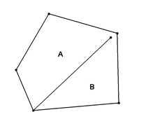
The area to the left was digitized by a “GIS Intern” and you were asked to “build” the topology. The software informs you that there is a label error. The label error could be the result of one of two things. Examine the diagram and choose one of the two possible errors.
Respuesta
-
Upper case text not allowed
-
Polygon with two labels not allowed
-
Unsnapped vertices
-
Incorrect polygon geometry
Pregunta 2
Pregunta
A street would be an example of what kind of data type?
Respuesta
-
Point
-
Line
-
Polygon
-
Raster
Pregunta 3
Pregunta
96º 30' 00” is an example of what coordinate format?
Respuesta
-
Degrees minutes seconds
-
Decimal degrees
-
Decimal minutes
-
State plane
Pregunta 4
Pregunta
A map projection is intended to
Respuesta
-
Correct for errors between the WGS 84 and Clark 1866 ellipsoids
-
Correct for errors when transforming spherical to planar coordinates
-
Correct for errors when converting between raster and vector data
-
Correct for errors in the digitizing process
Pregunta 5
Pregunta
A fire hydrant would be an example of what kind of data type?
Respuesta
-
Point
-
Line
-
Polygon
-
Raster
Pregunta 6
Pregunta
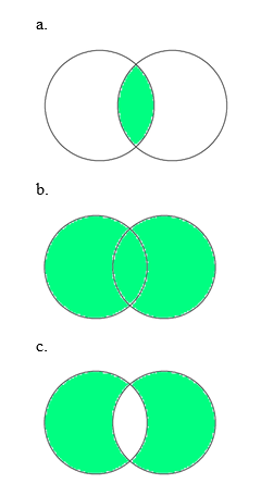
The following Venn diagrams illustrate the three Boolean operators common to GIS overlay operations. Match the operation name with the graphic it corresponds to.
Respuesta
-
Intersection
-
Union
-
Exclusive-or [XOR]
Pregunta 7
Pregunta
A City council district would be an example of what kind of data type
Respuesta
-
Point
-
Line
-
Polygon
-
Raster
Pregunta 8
Pregunta
96º 32.00' is an example of decimal minutes coordinate format.
Respuesta
- True
- False
Pregunta 9
Pregunta
You have been asked to find address points within 100 feet of a fire hydrant. What kind of GIS operation would you perform?
Respuesta
-
Spatial join
-
Buffer
-
Thiessen
-
Clip
Pregunta 10
Pregunta
96.500º is an example of what coordinate format?
Respuesta
-
Degrees Minutes seconds (DMS)
-
Decimal Degrees
-
Decimal minutes
-
State Plane
Pregunta 11
Pregunta
The two common data models used in GIS are raster and vector. Below are a list of advantages and disadvantages of each data type. Select the characteristics that describe the RASTER data model below.
Respuesta
-
Large storage requirements
-
High spatial variability efficiently represented
-
Better suited to image manipulation
-
Smaller storage requirements
-
Better suited to network analysis
-
Poorly represents high spatial variability
Pregunta 12
Pregunta
The two common data models used in GIS are raster and vector. Below are a list of advantages and disadvantages of each data type. Select the characteristics that describe the VECTOR data model below.
Respuesta
-
Large storage requirements
-
High spatial variability efficiently represented
-
Better suited to image manipulation
-
Smaller storage requirements
-
Better suited to network analysis
-
Poorly represents high spatial variability
¿Quieres crear tus propios Tests gratis con GoConqr? Más información.