
Fichas
GEO 1111 - FINAL - Glaciers
Fichas del conjunto (30)
- 1What are the types of glaciers?Ice sheets -- associated with continental glaciation and cover large areas of a landmass. exist in Greenland and Antarctica
Ice caps -- similar to ice sheets but are much smaller. they are usually found in the highest part of a mountain range, where the snow accumulation is the greatest.
Valley glaciers --discharge of ice from ice sheets, ice capsand mountain glaciers into low elevation valley glaciers.
Alpine glaciers -- begin high up in the mountains in bowl-shaped hollows called cirques
Mountain glaciers -- a sheet of alpine glaciers formed together as one mass/whole - 2What is the difference between ice patches and glaciers?ice patches are permanently existing snow accumulations that did not grow big enough to flow like glaciers.
- 3Antarctic's Ice Sheetlargest single ice mass on earth
amount of ice is equivalent to 58m of sea-level rise
East Antarctic rests on a major land mass, where as the west is partially below sea level. this makes the east more stable. - 4Greenland Ice Sheetroughly 80% of the surface of Greenland
ice sheet is equivalent to 7.2m sea level rise.
removal/melting of ice is by surface melting and runoff - 5How does snow transform into ice?Recrystallization : Each year, new layers of snow bury and compress the previous layers. This compression forces the snow to re-crystallize, forming grains that are similar in size and shape to grains of sugar.
Firn : Gradually the grains grow larger and the air pockets between the grains get smaller, causing the snow to slowly compact and increase in density. After about two winters, the snow turns into firn—an intermediate state between snow and glacier ice.
Glacial Ice : after 100s of years of occlusion, the porosity of the firn becomes < 10% is - 6What is a glacier budget?Glacial ice recedes or accumulates depending on the balance of accumulation and ablation
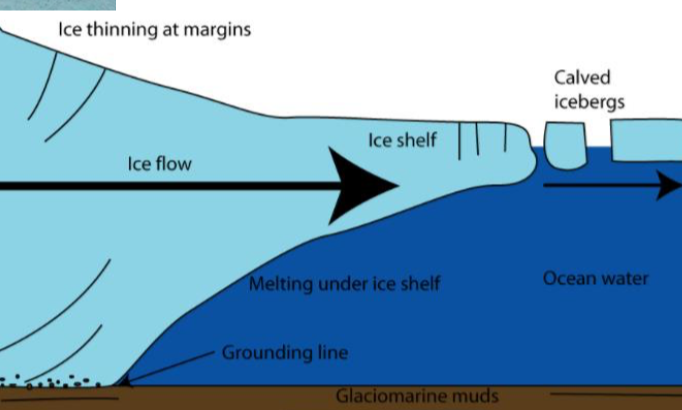
If the firn limit moves downslope, then the glacier has a positive budget. - 7Equilibrium Line / Firn LineA line across the glacier, from edge to edge, that marks the transition between exposed glacier ice, and the snow-covered surface of a glacier.
During the summer melt season, this line migrates up-glacier. At the end of the melt season the firn line separates the accumulation zone from the ablation zone - 8Area of Accumulation Ratio (AAR)area of accumulation/total area.
used in glacier reconstruction. generally 0.6 - 0.9 for most glaciers - 9Accumulationthe accumulation zone is the area above the firn line, where snowfall accumulates and exceeds the losses from ablation
5cm ice for dry Atlantic ice sheet
300cm for Vatnajökull Glacier, Iceland. - 10AblationAblation zone refers to the low-altitude area of a glacier or ice sheet below firn with a net loss in ice mass due to melting, sublimation, evaporation
- 11CalvingCalving is when chunks of ice break off at the terminus, or end, of a glacier. Ice breaks because the forward motion of a glacier makes the terminus unstable. creates the loss of ice directly into seawater. Forms icebergs
- 12Factors cause glaciers to move Basal SlidingThe entire glacier moves as a single mass over the underlying rock surface. The pressure from the weight of the glacier generates a layer of water that helps the ice glacier move downslope.
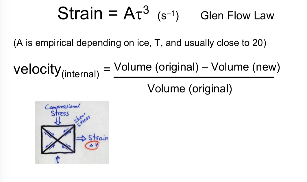
- 13Factors cause glaciers to move Stress-StrainGlaciers flow downslope in response to their driving stresses, which are a function of the weight of the ice and gravity. ‘Strain’ is the deformation of glacier ice in response to this stress. The gravitational driving stress and the ability of ice to deform control a glacier’s velocity
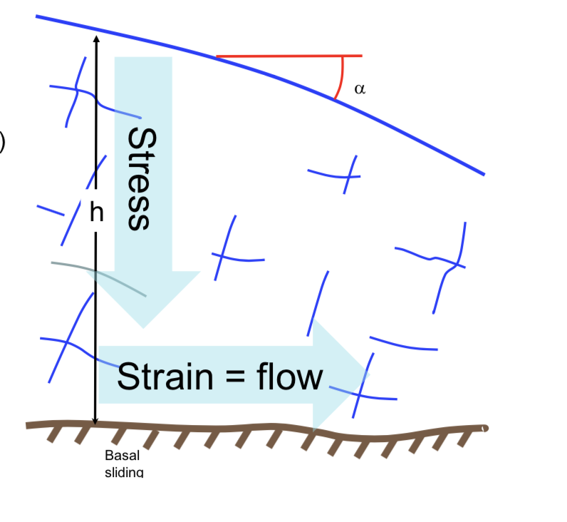
- 14Factors cause glaciers to move Basal CreepThe response of glacier ice to the stress of its own weight is to deform and creep
- 15Factors cause glaciers to move Surgingshort-lived events where a glacier can advance substantially, moving at velocities up to 100 times faster than normal. Surging glaciers cluster around a few areas
- 16Factors cause glaciers to move Streaminga region of an ice sheet that moves significantly faster than the surrounding ice.
They are up to 50 kilometres wide, 2 km thick, can stretch for hundreds of kilometres, and account for most of the ice leaving the ice sheet.
The shear forces at the edge of the ice stream cause deformation and recrystallization of the ice, making it softer, and concentrating the deformation in narrow bands or shear margins. - 17Glen Flow Law
- 18Flow Velocity
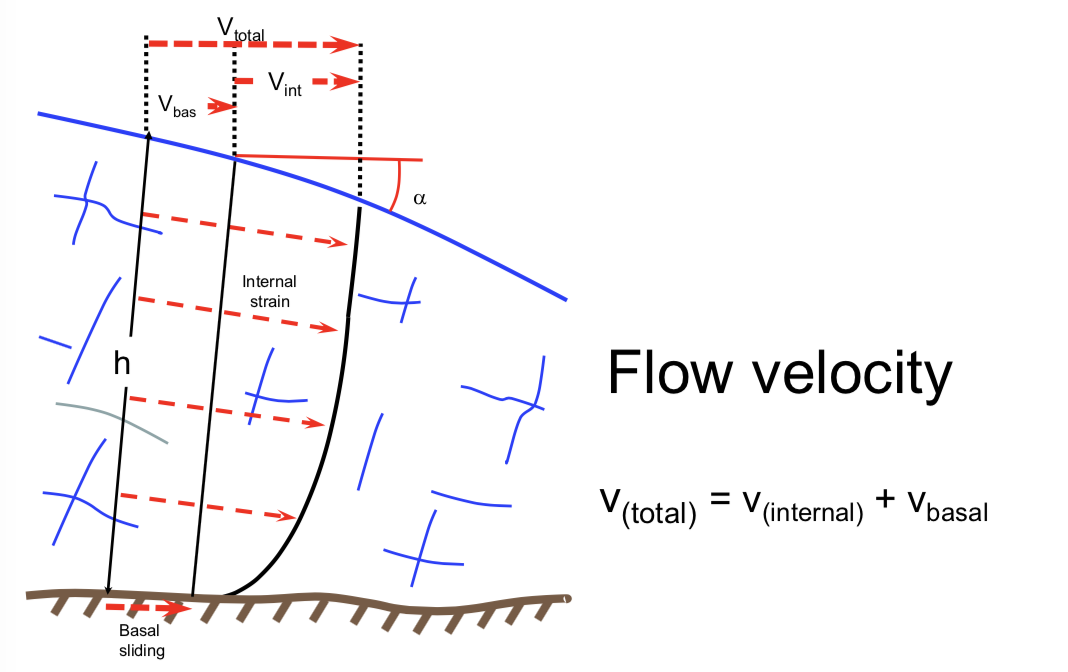
- 19How were the Great Lakes formed?Glacial erosion of the softer sedimentary rocks of the Michigan Basin, during several glaciation cycles over the Pleistocene ice ages, carved out four basins of the Great Lakes.
- 20Glacial Tillunsorted glacial sediment. Till is derived from the erosion and entrainment of material by the moving ice of a glacier.
- 21Basal or Lodgement TillWhen this deposition occurs at the base of the moving ice of a glacier, the sediment is called lodgement till
deposited beneath the glacier, so it is compacted - 22Marine MudQuick clay, also known as Leda clay, is any of several distinctively sensitive glaciomarine clays. A good example of quick clays being formed is the Champlain sea in Canada.
the late glacial period that occurred 12 000 to 10 000 years ago created a depressed land, this caused the sea levels to rise.
When the glaciers receded, the depressed land was filled with the ocean water. Slowly the depressed land rebounded, and the Champlain Sea area has gradually become an erosional environment. When properly drained, marine clays are left over. - 23MorainesMoraines are accumulations of dirt and rocks that have fallen onto the glacier surface or have been pushed along by the glacier as it moves. The dirt and rocks composing moraines can range in size from powdery silt to large rocks and boulders. A receding glacier can leave behind moraines that are visible long after the glacier retreats.
- 24EskerEskers are a product of the meltwater drainage plumbing at the ablating margin of the ice sheet.
long, narrow, winding ridge composed of stratified sand and gravel deposited by a subglacial or englacial meltwater stream - 25What are some economic values of glacial sediments?1) forms industry for roads and for concrete
2) the Champlain sea sediments provide rich soils for agriculture - 26Snowball EarthGlacial evidence on land demonstrates that, approx. 720 Million years ago, Earth’s oceans and land surfaces were once covered by ice from the poles to the Equator during a major glaciation event due to extreme cooling.
The end of the snowball earth brought on an influx of nutrients, and a change to new animal life formed, creating the Ediacaran Period. - 27Ediacaran Lifefollowing the snowball earth, the Ediacaran era evolved as the first multicellular animals.
this was approx. 635-541 million years ago, and it proceeded the explosion of life in the Cambrian Period - 28What is the difference between Ablation Abrasion ?Ablation : the low-altitude area of a glacier or ice sheet below firn with a net loss in ice mass due to melting
Abrasion : occurs when rocks and stones become embedded in the base and sides of the glacier - 29What is a Drumlin?A landform of shaped moraine.
it forms when a glacier moves over the moraine in a valley
as the glacier meets the moraine, it begins to travel over it. it does not have enough energy to cause the moraine to flow, and it cannot erode the resistant rock inside the moraine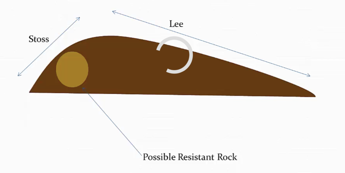
- 30What is the Pleistocene time period?earlier and major of the two time periods that constitute the Quaternary Period of the Earth’s history
its the time period during which extensive ice sheets and other glaciers formed repeatedly on the landmasses and has been informally referred to as the “Great Ice Age.”
Información
- Descripción
- El usuario ha eliminado su información de asignaturas Fichas sobre GEO 1111 - FINAL - Glaciers , creado por Usuario eliminado el 12/04/2018.
- Creado por
- Usuario eliminado · abr 2018
- Actualizado
- 12 abr 2018
- Visitas
- 19
- Historial
-
- Creado por abby Radske · 12 abr 2018
- Copiado por abby Radske · 12 abr 2018
- Valoración