
Test
Unit 1 - Mapping and Geotechnologies
Crea una cuenta gratis para terminar este test
Guarda tu progreso y consulta tu resultado final.
¿Ya tienes cuenta? Inicia sesión
Preguntas del test (50)
1What is Geography?
- AThe study of location and place.
- BThe study of animals.
- CIt is only about maps.
- DIt is the study of people and why they live where they do.
2What are the two Geography Disciplines?
- AHuman and Physical
- BLandforms and Ecology
- CGeology and Physical
- DGIS and GPS
3Which of the following is NOT an area of study for Human Geography?
- ALandforms
- BImmigration
- CPopulation
- DRock Cycle
4Which of the following is NOT an area of Physical Geography?
- AMaps
- BPlate Tectonics
- CSustainability
- DClimate
5What is a map?
- AA representation of Earth's features on a flat surface.
- BA very complicated colour drawing.
- CSatellites in space provide locational information.
- DA drawing with a lot of details and has a scale.
6What are the six map requirements?
- ATitle, Legend, Scale, Date, Direction, and Border
- BTitle, Scale, Distance, Compass Ross, Date and Border
- CTitle, Distance, Instructions, Directions, Scale and Border
- DTitle, Scale, Distance, Legend, Compass Rose and Border
7What is a Large Scale Map?
- AA map that shows a large amount of detail in a small area.
- BA map that shows a small amount of detail in a large area.
- CA map that shows a large amount of detail in a large area.
- DA map that shows a small amount of detail in a small area.
8What is an example of a Large Scale Map?
- AA map of the world.
- BA map used for hiking.
- CA map found in an atlas.
- DA map that shows Europe.
9What scale would a large scale map typically have?
- A1:25,000
- B1:250,000
- C1:2,500,000
- D1:250,00,000
10What is a small Scale Map?
- AA map that shows a large amount of detail in a small area.
- BA map that shows a small amount of detail in a large area.
- CA map that shows a large amount of detail in a large area.
- DA map that shows a small amount of detail in a small area.
11What is an example of a small scale map?
- AA map for hiking.
- BA map of the Appleby Campus.
- CA map of the world.
- DA map used in a shopping mall.
12What scale would a small scale map typically have?
- A1:25,000
- B1:15,000
- C1:2,500,000
- D1:30,000
13A General purpose map
- Acontains many types of information on one map
- Bcontains information on only one topic or theme
- Clarge-scale map showing both natural and human-made features.
- Dthe location of geographic data is digitized, placed in databases, and used in various combinations to create maps.
- Acontains many types of information on one map
14A Thematic Map
- Acontains many types of information on one map
- Bcontains information on only one topic or theme
- Clarge-scale map showing both natural and human-made features.
- Dthe location of geographic data is digitized, placed in databases, and used in various combinations to create maps.
15A Topographic Map
- Acontains many types of information on one map
- Bcontains information on only one topic or theme
- Clarge-scale map showing both natural and human-made features.
- Dthe location of geographic data is digitized, placed in databases, and used in various combinations to create maps.
16A Digital Map
- Acontains many types of information on one map
- Bcontains information on only one topic or theme
- Clarge-scale map showing both natural and human-made features.
- Dthe location of geographic data is digitized, placed in databases, and used in various combinations to create maps.
17What direction is at the Question Mark?
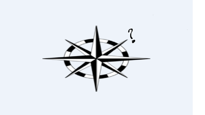
- ANorth East
- BSouth East
- CNorth West
- DSouth West
18What direction is at the Question Mark?
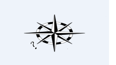
- ASouth East
- BNorth East
- CSouth West
- DNorth West
19Which of the following is NOT a cardinal point?
- ANorth East
- BNorth
- CEast
- DSouth
20What direction is opposite of NE?
- ASW
- BNW
- CSE
- DS
21What direction is the opposite of NNW?
- ASSE
- BNNE
- CSSW
- DESE
22What type of grid system is shown?
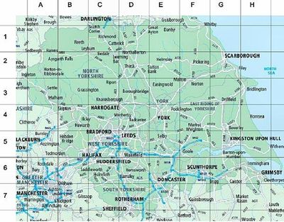
- AAlphanumeric
- BMilitary
- CGeneral Purpose
- DDigital
23What type of grid is shown?
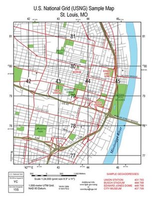
- AAlphanumeric
- BMilitary
- CGeneral Purpose
- DDigital
24What is true about an Easting?
- AThe numbers of the vertical lines increase as you move west to east.
- BThe numbers of the vertical lines decrease as you move west to east.
- CThe numbers of the horizontal lines increase as you move south to north
- DThe numbers of the horizontal lines decrease as you move south to north
- AThe numbers of the vertical lines increase as you move west to east.
25What is true about a Northing?
- AThe numbers of the horizontal lines increase as you move south to north.
- BThe numbers of the horizontal lines decrease as you move south to north.
- CThe numbers of the vertical lines increase as you move west to east.
- DThe numbers of the vertical lines decrease as you move west to east.
- AThe numbers of the horizontal lines increase as you move south to north.
26The prime meridian runs through which place on Earth?
- AGreenwich
- BOttawa
- CLondon
- DParis
27Which of the following statements about Lines of Latitude is FALSE?
- ARun east-west around the globe
- BAre parallel to the equator
- CAre located approximated 111 km apart
- DRun up to 90̊ north and 90̊ south
- EAll of the above are correct.
- ARun east-west around the globe
28Which of the following statements about Lines of Longitude are incorrect?
- ARun north and south
- BMeet at the poles
- CAre measured up to180̊ east and 180̊ west of the Prime Meridian.
- DAre different sizes at different places around the globe.
- ARun north and south
29Where is Oakville located?
- ANorth West Hemisphere
- B43° 25' 60 N
- C79° 40' 0 W
- DAll of the above are correct.
30What hemisphere is Russia in?
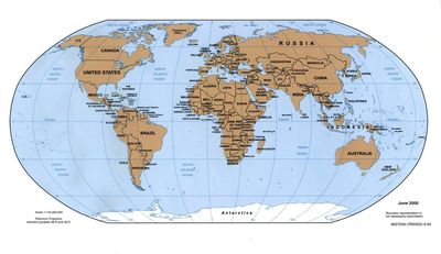
- ANE
- BNW
- CSE
- DSW
31What does GPS stand for?
- AGlobal Positioning System
- BGlobal Parallel System
- CGeographic Positioning System
- DGeographic Positioning Site
32What does GIS stand for?
- AGeographic Information Systems
- BGlobal Information System
- CGlobal Information Satellite
- DGeographic Information Satellite
33A GPS
- ANeeds at least 24 satellites to ensure that at least 4 are visible at any time.
- BOnly works during the daytime because the satellites do not work in the dark.
- CShows you exactly where you are on a map.
- DDoes not work well when it is foggy.
34When we examined the movement of the Mountain Pine Beetle using a GIS, how was the information (attribute data) about the Pine Beetles show on the base map?
- AIt was a layer of information.
- BIt was a picture of information.
- CIt was just a computer generated image.
- DThe pine beetle attribute data was not shown on the map.
35Technology that is used for studying the earth from a distance is called
- ARemote sensing
- BSatellites
- CGPS
- DGIS
36If you had your exact location on Earth from a GPS, what could you put it in to create a map to see where you are?
- AGIS
- BGPS
- CLayer
- DPicture
37A Direct Statement Scale
- Awords are used to describe the relationship between a distance on a map and a specific distance on Earth’s surface.
- Bline divided into units of distance that represent the actual units on the ground.
- Cscale on a map given as a ration of distance on the map to distance on the ground.
- Dcan only be found on a large scale map.
- Awords are used to describe the relationship between a distance on a map and a specific distance on Earth’s surface.
38Line Scale
- Awords are used to describe the relationship between a distance on a map and a specific distance on Earth’s surface.
- Bline divided into units of distance that represent the actual units on the ground.
- Cscale on a map given as a ration of distance on the map to distance on the ground.
- Donly found on a large scale map
- Awords are used to describe the relationship between a distance on a map and a specific distance on Earth’s surface.
39Representative Fraction Scale
- Ascale on a map given as a ration of distance on the map to distance on the ground.
- Bline divided into units of distance that represent the actual units on the ground.
- Cwords are used to describe the relationship between a distance on a map and a specific distance on Earth’s surface.
- Dis only found on a small scale map.
- Ascale on a map given as a ration of distance on the map to distance on the ground.
40What type of Scale is this?
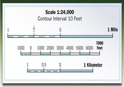
- ALine Scale
- BRepresentative Fraction Scale
- CDirect Statement Scale
- DRatio Scale
41If a Representative Fraction Scale is expressed as 1:50,000. What is the Direct Statement Scale?
- A1 cm = .5 km
- B1 cm = 5 km
- C1 cm = 50 km
- D5 cm = .1 km
42If 1 cm on a map equals 2.5 km on the Earth, or 1 cm = 2.5 km, what is the Representative Fraction Scale?
- A1:250,000
- B1:25,000
- C1:2,500
- D1:2,500,000
43How many time zones are there?
- A14
- B24
- C180
- D360
44Approximately, using degrees, how far apart are each time zone?
- A15 degrees
- B360 degrees
- C24 degrees
- D90 degrees
45How many time zones does Canada have?
- A6
- B4
- C5
- D7
46Who introduced the idea of standard time?
- ASir Sandford Fleming
- BJohn A. MacDonald
- CLouis Riel
- DJohn Guest
47Time zones that are east of the Prime Meridian
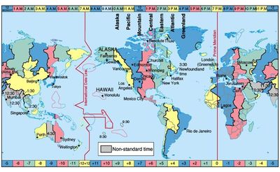
- AAre ahead of Universal Time (UT)
- BAre behind Universal Time (UT)
- CAre a day ahead of Universal Time (UT)
- DAre a day behind Universal Time (UT)
48Time zones that are west of the Prime Meridian
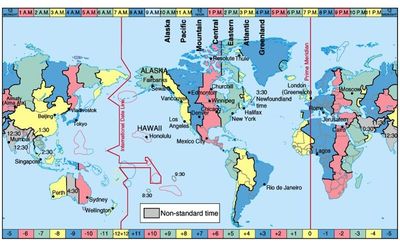
- AAre ahead of UT
- BAre behind UT
- CAre a day ahead of UT
- DAre a day behind UT
49If you cross the International Date Line moving westward
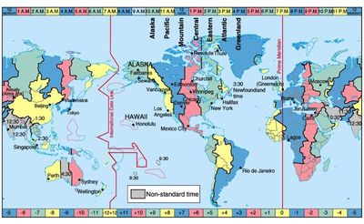
- AYou add a day
- BYou lose a day
- CYou are one hour ahead of UT
- DYou are one hour behind UT
50If you cross the International Date Line move eastward
- AYou add a day
- BYou lose a day
- CYou are one hour ahead of UT
- DYou are one hour behind UT
Información
- Descripción
- Here is a Multiple Choice Quiz to help you to understand the concepts and also to practice answering this type of question.
- Autor
- gstoneman
- Idioma
- English
- Visitas
- 483
- Valoración
- Aún sin valoraciones Valora este test