
Test
2 NAVIG. EXAM. PREP.
Crea una cuenta gratis para terminar este test
Guarda tu progreso y consulta tu resultado final.
¿Ya tienes cuenta? Inicia sesión
Preguntas del test (35)
127 A full scale deflection of a VOR needle (CDI) shows an angular deflection of ______ from the selected radial.
- AO At least 10 degrees
- BO At least 5 degrees
- CO At least 20 degrees
228 Which radial has to be selected on the omnibearing selector (OBS) of a VOR in order to center the needle(CDI) with a TO indication if the aeroplane's position is east of the station?
- AO '270
- BO '090
- CO '180
- DO '360
329 One nautical mile is equal to:
- AO '6080ft
- BO '6800ft
- CO '5280ft
- DO '3280ft
430 Isogonic lines are lines which connect places with the same magnetic variation.
- AO True
- BO False
531 Which is the order that geographic coordinates are given?
- AO Latitude first then longitude
- BO Longitude first then latitude
632 Which of the following charts has the biggest scale?
- AO '1:250.000
- BO '1:500.000
- CO '1:1.000.000
733 Which transponder code is used in case of two-way radio communication failure?
- AO '7600
- BO '7700
- CO '7500
834 If the surface wind of an airport is 020/35kts what is the crosswind component for a take off from runway 33?
- AO '27kts
- BO '33kts
- CO '22kts
- DO '17kts
935 Which temperature on the Fahrenheit scale equals 15C (Celsius)?
- AO '59F
- BO '49F
- CO '65F
- DO '69F
1036 What do you expect to be different during a climb with a strong headwind compared to a climb with calm wind?
- AO The angle of climb
- BO The rate of climb
- CO The true airspeed
1137 If a flight is made from an area of high pressure to an area of lower pressure without the altimeter setting being adjusted the altimeter will indicate:
- AO Higher than the actual altitude above sea level.
- BO Lower than the actual altitude above sea level.
- CO The actual altitude above sea level.
1238 Which transponder code will you use in the event of an engine failure?
- AO '7700
- BO '7500
- CO '7600
1339 What is the maximum acceptable bearing error for a VOR accuracy check with a designated ground checkpoint?
- AO '± 4 degrees
- BO '± 5 degrees
- CO '± 6 degrees
- DO '± 10 degrees.
14121 Which cruising altitude is appropriate for a VFR flight on a magnetic course of 165 degrees?
- AO Odd thousands plus 500 feet.
- BO Even thousands
- CO Even thousands plus 500 feet.
- DO Odd thousands
15122 Which VFR cruising altitude is acceptable for a flight on a Victor Airway with a magnetic course of 175 degrees? The terrain is less than 1000 feet.
- AO 5500 feet
- BO 4500 feet
- CO 5000 feet
- DO 6000 feet
16123 Which VFR cruising altitude is appropriate when flying above 3000 feet AGL on a magnetic course of 185°?
- AO 4500 feet.
- BO 4000 feet.
- CO 5000 feet.
- DO 5500 feet.
17124 Each person operating an aircraft at VFR cruising altitude shall maintain an odd-thousand plus 500-foot altitude while on a
- AO Magnetic course of 0° through 179°.
- BO magnetic heading of 0° through 179°.
- CO true course of 0° through 179°.
- DO True heading of 0° through 179°.
18125 . Determine the magnetic course from Ermoupolis/Syros(LGSO) to Athinai/Hellinikon(LGAT).
- AO 295°.
- BO 118°.
- CO 264°.
- DO 114°.
19136 What is your approximate position on course from LGTS to LGBL, if the VOR receiver indicates you are on the radial 065 of LAR VOR?
- AO Akr. Dermatas.
- BO Plata Point.
- CO Akr. Platamon
- DO Over Litochoron LGD 74.
20137 What is your approximate position on course from Lamia-Army to Larissa(LGLR), if the VOR receiver indicates 285 radial of AGH VOR?
- AO Over Farsala.
- BO Over Volos .
- CO Over N.Anchialos (LGBL) indicating NAV flag.
- DO Over Stefanovikion-Army(LGSV).
21138 . The VOR receiver is tuned to LAR VOR and the aircraft is positioned over Platamon. Wich VOR is correct? Fig. 1.
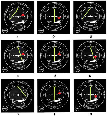
- AO 8.
- BO none.
- CO 5
- DO 6
22139 What course should be selected on the omni bearing selector (OBS) to make a direct flight from Skyros (LGSY) to SKL VOR with a TO indication.
- AO 288°.
- BO 108°.
- CO 010°.
- DO 190°.
23140 What is the approximate position of the aircraft if the VOR receivers, indicate the 235 radial of MKR VOR and the 205 radial of FISKA VOR? (Fig.1)
- AO Katero Point(City of Katerini).
- BO Sedes(LGSD)
- CO Alexandria-Army Airport(LGAX)
- DO Kora Point.(Koronia lake).
24141 The VOR receiver is tuned to MIL VORTAC and the aircraft is positioned over the Thira Island NE of Paros. Wich VOR indication is correct? (Fig.1)
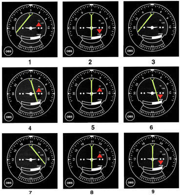
- AO 7.
- BO 1.
- CO 9.
- DO 5.
25142 The VOR receiver has the indication shown on Fig. 1/Illustration 1. What is the aircraft's position relative to the station?
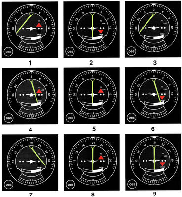
- AO South.
- BO North.
- CO East.
- DO West.
26126 Determine the magnetic heading for a flight from Lamia-Army airport to Stefanovikion-Army (LGSV). The wind is from 330° at 25 knots, the true airspeed is 100 knots.
- AO 009°.
- BO 360°.
- CO 020°
- DO 90°.
27127 Determine the magnetic heading for a flight from Skiathos (LGSK) to Tanagra (LGTG). The wind is from 215° at 25 knots and the true airspeed is 125 knots.
- AO 182°.
- BO 161°.
- CO 191°.
- DO 177°.
28128 What is the magnetic heading for a flight from Larisa (LGLA) to Stefanovikio-Army. The wind is from 030° at 12 knots and the true airspeed is 95 kts.
- AO 116°
- BO 123°.
- CO 130°.
- DO 360°.
29129 Determine the magnetic heading for a flight from Araxos(LGRX) to Preveza-Aktion(LGPZ). The wind is from 300° at 14 knots and the true airspeed is 90 knots.
- AO 320°.
- BO 325°.
- CO 331°.
- DO 090°
30130 Determine the compass heading for a flight from Thessaloniki-Makedonia(LGTS) to Kozani-Phillipos(LGKZ). The wind is from 070° at 16 knots and the true airspeed is 90 knots.Compass correction on fig.4.
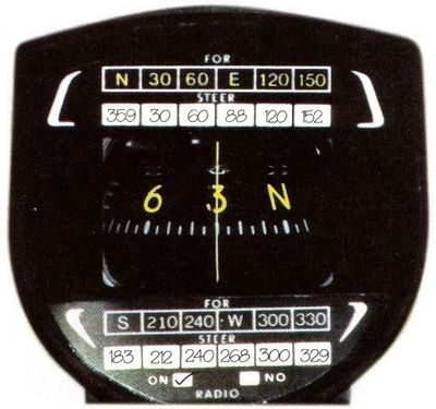
- AO 253°.
- BO 200°.
- CO 205°.
- DO 300°.
31131 . Determine the compass heading for a flight from Megara-Army(LGMG) to Skyros(LGSY). The wind is coming from 290/18 kts and the true airspeed is 85 knots. Compass correction on fig.4.
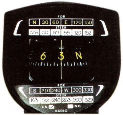
- AO 027°
- BO 050°
- CO 035°
- DO 045°
32132 Determine the compass heading for a flight from Tanagra(LGTG) to Elefsis (LGEL). The wind is calm and the true airspeed is 90 knots.Compass correction on fig.4.
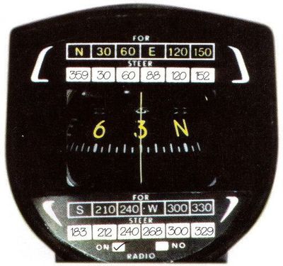
- AO 183°
- BO 123°.
- CO 186°.
- DO 220°.
33133 Determine the magnetic course from Kerkyra-Kapodistrias(LGKR) to Ioannina(LGIO).
- AO 080°.
- BO 075°.
- CO 091°.
- DO 262°.
34134 . Determine the magnetic heading from Larissa(LGLR) to Thessaloniki-Makedonia(LGTS) .The wind is from 330° at 25 knots, the true airspeed is 110 knots.
- AO 010°.
- BO 017°.
- CO 023°
- DO 195°
35135 Determine the compass heading from Limnos(LGLM) to Skyros(LGSY). (Fig.4)
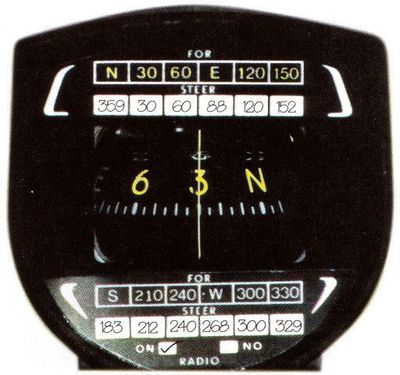
- AO 211°.
- BO 013°.
- CO 220°.
- DO 031°.
Información
- Descripción
- 2 NAVIG. EXAM. PREP.
- Autor
- tsampikos pompou
- Idioma
- English
- Visitas
- 930
- Etiquetas
- Valoración
- 5,0 de 5 · 2 valoraciones Valora este test