4637645
| Question | Answer |
| what is the water cycle? | precipitation surface/ground water transpiration/evaporation condensation |
| what is precipitation? | rainwater snow hail sleet |
| what is another word for sediment? | alluvium |
| what are the 4 factors that cause deposition? | river carries a large load of sediment reduction in velocity an obstruction fall in volume of river water |
| what is river discharge? | the volume of water passing through the river at any one time |
| what is river discharge measured in? | cumecs (cubic meters per second.) |
| what factors affect discharge? | land use temperature previous weather conditions rock type |
| what are the ideal conditions for high river discharge? | high land= heavy rainfall steep slopes= fast surface run off no interception impermeable rock= doesn't allow water to pass through) |
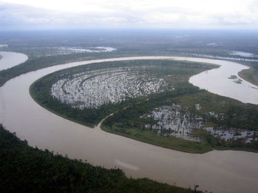
| features the upper course of a river? | interlocking spurs waterfalls gorges v-shaped valleys tributaries |
| processes of the upper course river? | vertical erosion |
| features of rivers, channels and bed loads of upper course river? | large, angular bed load narrow rivers and channels shallow rivers |
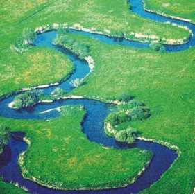
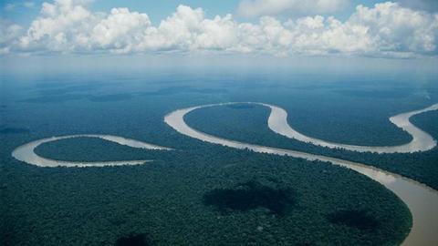
| features of the middle course of a river? | meanders tributaries wider, flatter valley oxbow lakes floodplain |
| processes of the middle course? | lateral erosion (horizontal) |
| features of the rivers, channels and bed loads in the middle course? | smaller rounded bed load |
| Features of the lower course river? | levees (raised river banks) floodplains river mouth tributaries delta (alluvium spreads into sea) |
| Processes of the lower course? | mostly suspended deposition suspention |
| features of rivers, channels and bed loads in lower course? | alluvium (fine sediment) |
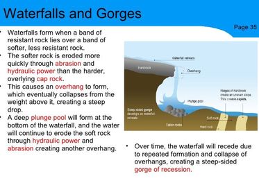
| how do waterfalls and gorges form? | |
| how do meanders form? | gradient of the river is falter (slope) lateral erosion takes place river current is stronger on the outside of the bend= erosion current is weaker on the inside= deposition overtime the river curves due to erosion on the outside and deposition on the inside |
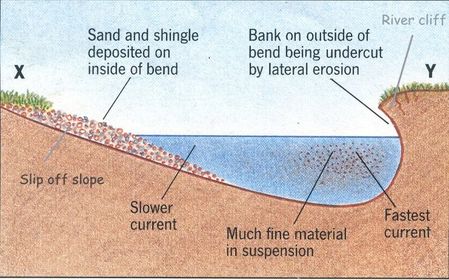
| cross section of a meander | |
| how do oxbow lakes form? | 1) erosion on the outside of the meander 2) over time the meander neck becomes narrower 3) during a flood, the river cuts through the meander neck 4) over time, deposition cuts off the meander, forming an oxbow lake 5) when the river dries up, it forms a meander scar |
| how are floodplains formed? | 1) over thousands of years the river carries alluvium from the upper and middle course 2) alluvium is then deposited 3) the river floods carrying alluvium over the river banks = more deposition 4) meanders migrate over time |
| way levees are formed? | 1) RIVER IN FLOOD: as water flows the energy is lost = heavy material is deposited on the bank 2) RIVER AT LOW FLOW: during dry spells the velocity slows down and the volume of water falls= deposition on the bed 3) AFTER REPEATED FLOODS: after many floods the river banks form levees and the bed may be raised= river rises above the flood plain and leads to more flooding |
| what is the definition of flooding? | anything that increases surface run off = increase in discharge |
| human causes of flooding | building houses on Greenfield sites= water can't soak into the ground ploughing= water runs faster through the channels that are created deforestation= water gets to the surface quicker (more likely to be saturated) |
| physical causes of flooding | dry weather= heat bakes ground= water can't be soaked into soil heavy rainfall= more water in the ground steep slopes= water runs off before infiltration antecedent rainfall= surface is already saturated impermeable rock= water can't percolate into the ground snow melt= more water in the river |
| what would reduce the risk of flooding? | afforestation improve drainage systems build on brownfield sites |
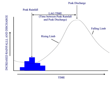
| what is this graph called? | a flood hydrograph |
| what does peak rainfall mean? | highest amount of rain |
| what does peak discharge mean? | highest amount of discharge |
| what does falling limb mean? | decreasing height of a river OR decreasing flood water in a river |
| what does rising limb mean? | rising flood water in a river |
| what does the lag time mean? | the time difference between the peak rainfall and peak discharge |
| what is hard engineering? | structures that are imposed on a river. these are man made and disrupt the natural environment. |
| examples of hard engineering | dams embankments channelization storage areas flood walls |
| what is soft engineering? | these are methods that work with the river and use natural processes. |
| examples of soft engineering? | afforestation warning systems land-use zoning washlands |
| what does water stress mean and what causes it? | the amount of water doesn't meet the requirement. CAUSES: inadequate supply at a particular time may relate to the water quality |
| what does areas of deficit mean and what causes it? | rain that falls doesn't provide enough water on a permanent basis in one Location CAUSES: shortages under certain conditions (long periods without rain) |
| what does areas of surplus mean and what causes it? | areas that have more water than needed CAUSES: areas that receive high rainfall but have a small population |
| what places in the UK have a water surplus? | North and West |
| what places in the UK have a water deficit? | South and East |
| what is the case study for water transfer in the UK? | Kielder Water, Northumberland |
| what are the advantages of Kielder Water? | habitats have been protected (especially for red squirrels) 1/4 million visits a year an eco-village nearby uses the waste chips from the forestry process to power the village jobs were made during the construction phase and through the maintenance of the dam wall |
| what are the disadvantages of Keilder Water? | 1.5 million trees were cut down to make reservoir an area of 'outstanding beauty' was flooded for the reservoir the dam stooped the migration of trout 7 families were rehoused as a result of flooding behind the dam |
Want to create your own Flashcards for free with GoConqr? Learn more.