8635845
Description
Flashcards by Niall Morrison, updated more than 1 year ago
|
|
Created by Niall Morrison
about 7 years ago
|
|
| Question | Answer |
| What is Relief? | Relief is the steepness of slopes, shapes of landscape features and height above sea level of land. This greatly depends on the geology of the land. |
| What is the Relief of the UK? | The South-East of the UK is generally flat land below 330 metres e.g. Cotswold Hills the South-West and the North is composed of steeper higher altitude land e.g. Arran The highest point is Ben Nevis |
| Give an example of a river | River Tees : from Cross Fell (823 m) to Darlington to Middlesbrough River Severn : West UK near welsh border |
| Name a waterfall | High Force on river tees 20 m drop hard rock is Dolerite soft is limestone |
| Four types of River Erosion? | Abrasion (Rocks hurled towards) Attrition (Rocks Banging Together) Hydraulic Action (Force from water in cracks) Solution (Dissolved rocks making water acidic) These can happen laterally or vertically |
| How does a river change as you move down? | Upper - Turbulent, Steep, lots of friction and varying water speeds usually slow but can speed up with rapids, narrow and shallow. Middle - More lateral and verticle erosion, wider and deeper, floodplains, less water touching surface faster flow Lower - Very gentle slope. Wider and deeper but deposition is dominant as water has lost energy depositing a lot of alluvium (levees). |
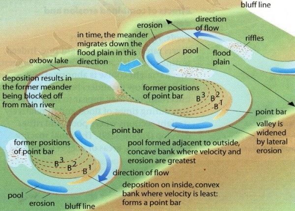
| Main features of courses? | Upper - V-Shaped River Valley Interlocking Spurs Middle - Meanders Ox-bow lakes Floodplains Lower - Levees Estuararies |
| What does a meander look like? | |
| Four types of transportation Big to Small? | Traction (Big rolling) Saltation (Medium skidding) Suspension (Floating) Solution (Dissolved) |
| Name a town which has carried out flood management. | Banbury |
| Describe the Banbury Floods | In 1998 Banbury was hit by a flood causing £12.5 in damages and disrupting homes and businesses. They were hit again in 2007 causing more disruption. |
| What has Banbury done to reduce flood risk? | In 2012 they devised a flood defence scheme including . A 2.9 km embankment parallel to M40 . Reservoir 3 million m^3 storage . Pumping . Biodiversity trees, animals to absorb excess water. - Cost 18.5 million + Less Anxiety + Less Destruction Costs + Contributes to environment |
| Describe Cockermouth Flood | On 19 November 2009 the river running through Cockermouth flooded causing mass destruction |
| Causes of Cockermouth Flood? | . Moist air forced up by relief causing heavy rainfall causing 31.4 cm of rain in 24 hours . Impermeable flood plain . Saturated soil . Cumbrian mountains steep |
| Physical Flood Causes? | - Preciptation (Heavy rain) - Geology (Impermeable rocks causing over flow) - Steep slopes (From mountains) |
| Human Flood Causes? | - Urbanization (Impermeable rocks and drainage into river) - Deforestation (Trees absorbing water) - Agriculture(Arable farming leads to impermeable land) |
| What is the name of river material? | Alluvium (Mud, Clay and Sand) |
| What is Hard Engineering | Hard engineering involves use of man made structures to prevent natural processes occuring |
| What is Soft Engineering | This involves working with the rivers natural processes to manage flood risk |
| Name 3 Soft Engineering Methods | Possible answers Afforestation Floodplain zoning River Restoration Wet lands and flood storage areas |
| Name 3 Hard Engineering Methods | Possible answers : Flood relief channels Embankments Dams and Reservoirs Channel Straightening (Cuts across meanders speeding up river flow) |
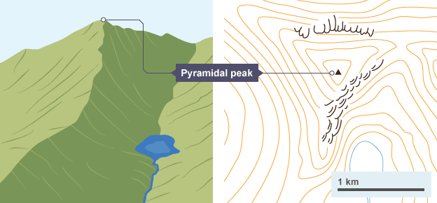
| Upper Course Glacier Features? | - Corries - Arêtes (2 corries meet) - Pyramidal peak (3 or more corries) |
| What does a pyramidal peak look like on a map? |
Image:
Pyramidal Peak (image/png)
|
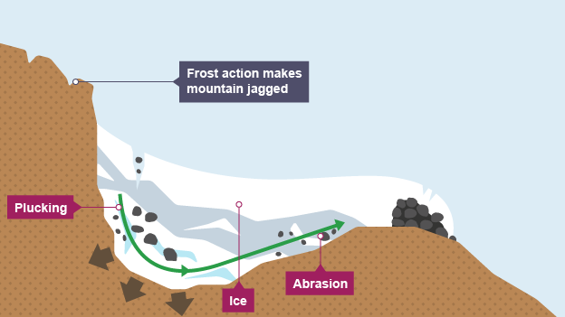
| What is freeze thaw? (Physical Weathering) | In the night in winters water enters the cracks of rocks and freezes expanding by 9% exerting stress and breaking rocks. This processes is repeated breaking off rocks called scree . Leaving a jagged landscape . Weakening rock for abrasion . Providing material for abrasion |
| Name the 2 glacial erosion methods | Abrasion (Rubbing scree on the rocks) Plucking (Freezing and prying off rocks) |
| Name the glacial sediment | Moraine - Lateral - Medial - Terminal - Ground |
| How is glacial sediment transported? | It either freezes in the ice then the ice melts or it is bulldozed by the glacier |
| Name 4 Features of a u-shaped glacial valley | - Glacial trough - Truncated Spurs (Cut across V-Shaped) - Ribbon lake (Tributaries join making thicker ice or band of less resistant rock) - Hanging valley |
| What does a corrie look like |
Image:
Large (image/png)
|
| Give an example of a corrie | Llyn Cau in wales\Mount Fuji Japan |
| Name the 4 main uses of glaciated areas. | . Farming (Fertile land) . Tourism . Quarrying . Forestry |
| Name 4 conflicts in glaciated areas | Possible answers : Quarrying and Farming (Making land unusable and damaging environment) Farming and Tourism (Gates left open and footpath erosion) Quarrying and Forestry Locals and Tourism Tourism and Quarrying |
| Why is the lake district attractive? | . Beautiful natural glacial landscape . Good for hiking, biking, rock climbing . Scafell Pike highest mountain in England . Scenic Villages like Ambleside . Inspired poets . Beatrix Potter writer of Peter Rabbit lived close to windmere |
| Social impacts of tourism in lake distirct | + In 2014 15 million tourists visited impacting 40,000 residents + 89% of tourist come by car causing congestion on narrow roads - 20 % of properties are tourism related increasing land prices - Seasonal jobs |
| Economic impacts of tourism in lake distirct | + £1 billion spent by tourists in 2014 + Many jobs + New businesses for local people - Traffic slows business activity |
| Economic impacts of tourism in lake distirct | - Footpath erosion - Physical pollution (litter, damage to verges by cars) - Walkers can damage farm crops and disturb sheep and cattle |
| How does the lake district manage traffic congestion? | Traffic Congestion : - Dual carriageway roads - Public Transport - Park and Ride Schemes - Traffic calming measures such as speed bumps These have greatly improved traffic congestion |
| How does the lake district manage footpath erosion? | The 'fix the fells' project involved replacing footpaths with more resistant locally sourced rocks to make the footpaths last longer but it still requires a lot of attention. |
Want to create your own Flashcards for free with GoConqr? Learn more.