Amazonía u Oriente

Description

Educación Flowchart on Amazonía u Oriente, created by MARIA VICTORIA ENCALADA NUÑEZ on 07/01/2021.
MARIA VICTORIA ENCALADA NUÑEZ
Flowchart by MARIA VICTORIA ENCALADA NUÑEZ, updated more than 1 year ago
MARIA VICTORIA ENCALADA NUÑEZ
Created by MARIA VICTORIA ENCALADA NUÑEZ over 3 years ago
7
0

Resource summary

Flowchart nodes

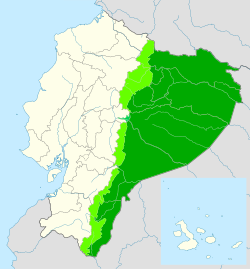
  • La Amazonía u Oriente
  • Provincias  Sucumbíos Orellana Napo Pastaza Morona Santiago Zamora
  • Es una región natural del país sudamericano conformada por un área aproximada de 120.000 km² de la Amazonia.
  • Representa el 43% del territorio ecuatoriano. Sus límites están marcados por la Cordillera de los Andes en la parte occidental de esta región, mientras que Perú y Colombia 
Show full summary Hide full summary

Similar

diapositivas constructivismo
Katita Salgado
Introducción a Desarrollo de Habilidades de Pensamiento (DHP)
Sebastian Moreno Rodriguez
Pedagogía general para la enseñanza de las ciencias
Leonardo Ibañez Calvo
EL CENTRO ESCOLAR COMO ORGANIZACIÓN, SISTEMA SOCIAL Y COMUNIDAD
Lorena Hernandez
TEORÍAS EDUCATIVAS/UNIVERSIDAD PANAMERICANA
Teodoro Alberto Pérez Duering
MAPA MENTAL
blanca beatriz m
Mapas mentales con ExamTime
Nazareth Olivo
Las TIC y la Educación
Carlos Vásquez
Esquemas
Ximena Barrera