
23049541
Description

Mind Map by Sebastian Valencia, updated more than 1 year ago

|
Created by Sebastian Valencia
over 6 years ago
|
|
Extremos y Límites del Ecuador
- Limites
- Al norte limita con Colombia
- Limite natural el Río Mataje
- Limite natural el Río Mataje
- Al Sur y Este limita con Perú
- Partiendo del Archipiélago
de Jambelí
- Boca de Capones
- Estero Grande
- Hasta el Río Zarumilla
- Hasta el Río Zarumilla
- Estero Grande
- Boca de Capones
- Partiendo del Archipiélago
de Jambelí
- Al Oeste limita con el Océano Pacífico
- Al norte limita con Colombia
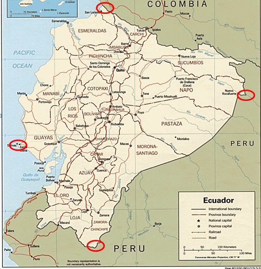
- Puntos Extremos
- Al norte, la desembocadura del río Mataje (01º 27' 06)
- Al sur, la confluencia del río San Francisco y el río Chinchipe (05º 00' 56)
- Al este, la confluencia del río Napo y el río Aguarico (75º 11' 49)
- Al oeste, la Punta de Santa Elena (81º 00' 40)
- Al norte, la desembocadura del río Mataje (01º 27' 06)
Media attachments
Want to create your own Mind Maps for free with GoConqr? Learn more.