
Módulo 10 de 12 · Mídia
G009
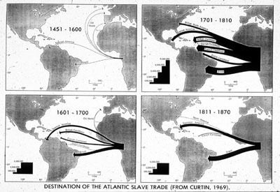
Image Reference
G009
Source
Adapted from Philip D. Curtin, The Atlantic Slave Trade (Madison: University of Wisconsin Press, 1969).
Comments
This image is a composite of 4 separate maps published in Curtin. The four maps show the numbers of slaves transported from Africa to New World areas over the period 1451-1870; thickness of arrows indicates numbers of enslaved to each major area. Although the numbers in this map would be different in light of research since Curtin's pioneering work was published, the map still gives a graphic idea of the relative intensity of the Atlantic slave trade to New World areas through time.