
Flashcards
AQA Geography GCSE 9-1 Relief, Rivers, Glaciers
Flashcards do conjunto (38)
- 1What is Relief?Relief is the steepness of slopes, shapes of landscape features and height above sea level of land.
This greatly depends on the geology of the land. - 2What is the Relief of the UK?The South-East of the UK is generally flat land below 330 metres e.g. Cotswold Hills
the South-West and the North is composed of steeper higher altitude land e.g. Arran
The highest point is Ben Nevis - 3Give an example of a riverRiver Tees : from Cross Fell (823 m) to Darlington to Middlesbrough
River Severn : West UK near welsh border - 4Name a waterfallHigh Force on river tees 20 m drop hard rock is Dolerite soft is limestone
- 5Four types of River Erosion?Abrasion (Rocks hurled towards)
Attrition (Rocks Banging Together)
Hydraulic Action (Force from water in cracks)
Solution (Dissolved rocks making water acidic)
These can happen laterally or vertically - 6How does a river change as you move down?Upper -
Turbulent, Steep, lots of friction and varying water speeds usually slow but can speed up with rapids, narrow and shallow.
Middle -
More lateral and verticle erosion, wider and deeper, floodplains, less water touching surface faster flow
Lower -
Very gentle slope. Wider and deeper but deposition is dominant as water has lost energy depositing a lot of alluvium (levees). - 7Main features of courses?Upper -
V-Shaped River Valley
Interlocking Spurs
Middle -
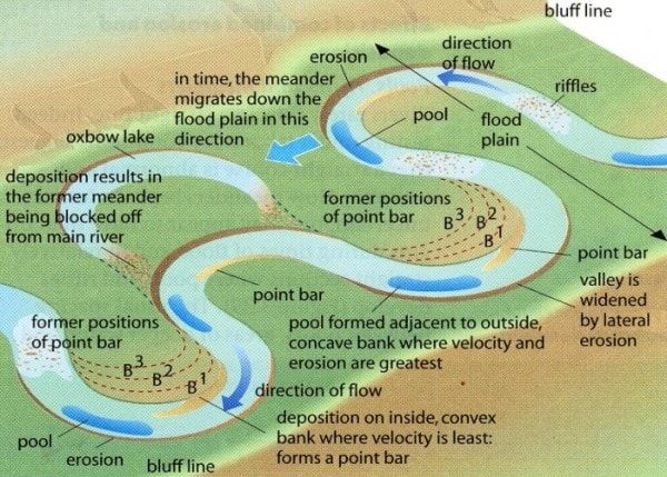
Meanders
Ox-bow lakes
Floodplains
Lower -
Levees
Estuararies - 8What does a meander look like?
- 9Four types of transportation Big to Small?Traction (Big rolling)
Saltation (Medium skidding)
Suspension (Floating)
Solution (Dissolved) - 10Name a town which has carried out flood management.Banbury
- 11Describe the Banbury FloodsIn 1998 Banbury was hit by a flood causing £12.5 in damages and disrupting homes and businesses. They were hit again in 2007 causing more disruption.
- 12What has Banbury done to reduce flood risk?In 2012 they devised a flood defence scheme including
. A 2.9 km embankment parallel to M40
. Reservoir 3 million m^3 storage
. Pumping
. Biodiversity trees, animals to absorb excess water.
- Cost 18.5 million
+ Less Anxiety
+ Less Destruction Costs
+ Contributes to environment - 13Describe Cockermouth FloodOn 19 November 2009 the river running through Cockermouth flooded causing mass destruction
- 14Causes of Cockermouth Flood?. Moist air forced up by relief causing heavy rainfall causing 31.4 cm of rain in 24 hours
. Impermeable flood plain
. Saturated soil
. Cumbrian mountains steep - 15Physical Flood Causes?- Preciptation (Heavy rain)
- Geology (Impermeable rocks causing over flow)
- Steep slopes (From mountains) - 16Human Flood Causes?- Urbanization (Impermeable rocks and drainage into river)
- Deforestation (Trees absorbing water)
- Agriculture(Arable farming leads to impermeable land) - 17What is the name of river material?Alluvium (Mud, Clay and Sand)
- 18What is Hard EngineeringHard engineering involves use of man made structures to prevent natural processes occuring
- 19What is Soft EngineeringThis involves working with the rivers natural processes to manage flood risk
- 20Name 3 Soft Engineering MethodsPossible answers
Afforestation
Floodplain zoning
River Restoration
Wet lands and flood storage areas - 21Name 3 Hard Engineering MethodsPossible answers :
Flood relief channels
Embankments
Dams and Reservoirs
Channel Straightening (Cuts across meanders speeding up river flow) - 22Upper Course Glacier Features?- Corries
- Arêtes (2 corries meet)
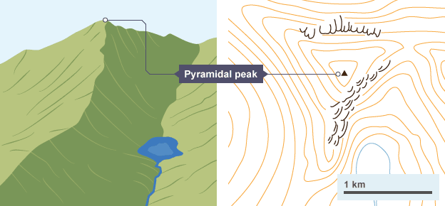
- Pyramidal peak (3 or more corries) - 23What does a pyramidal peak look like on a map?
- 24What is freeze thaw? (Physical Weathering)In the night in winters water enters the cracks of rocks and freezes expanding by 9% exerting stress and breaking rocks. This processes is repeated breaking off rocks called scree
. Leaving a jagged landscape
. Weakening rock for abrasion
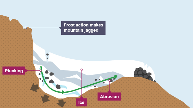
. Providing material for abrasion - 25Name the 2 glacial erosion methodsAbrasion (Rubbing scree on the rocks)
Plucking (Freezing and prying off rocks) - 26Name the glacial sedimentMoraine
- Lateral
- Medial
- Terminal
- Ground - 27How is glacial sediment transported?It either freezes in the ice then the ice melts or it is bulldozed by the glacier
- 28Name 4 Features of a u-shaped glacial valley- Glacial trough
- Truncated Spurs (Cut across V-Shaped)
- Ribbon lake (Tributaries join making thicker ice or band of less resistant rock)
- Hanging valley - 29What does a corrie look like
- 30Give an example of a corrieLlyn Cau in wales\Mount Fuji Japan
- 31Name the 4 main uses of glaciated areas.. Farming (Fertile land)
. Tourism
. Quarrying
. Forestry - 32Name 4 conflicts in glaciated areasPossible answers :
Quarrying and Farming (Making land unusable and damaging environment)
Farming and Tourism (Gates left open and footpath erosion)
Quarrying and Forestry
Locals and Tourism
Tourism and Quarrying - 33Why is the lake district attractive?. Beautiful natural glacial landscape
. Good for hiking, biking, rock climbing
. Scafell Pike highest mountain in England
. Scenic Villages like Ambleside
. Inspired poets
. Beatrix Potter writer of Peter Rabbit lived close to windmere - 34Social impacts of tourism in lake distirct+ In 2014 15 million tourists visited impacting 40,000 residents
+ 89% of tourist come by car causing congestion on narrow roads
- 20 % of properties are tourism related increasing land prices
- Seasonal jobs - 35Economic impacts of tourism in lake distirct+ £1 billion spent by tourists in 2014
+ Many jobs
+ New businesses for local people
- Traffic slows business activity - 36Economic impacts of tourism in lake distirct- Footpath erosion
- Physical pollution (litter, damage to verges by cars)
- Walkers can damage farm crops and disturb sheep and cattle - 37How does the lake district manage traffic congestion?Traffic Congestion :
- Dual carriageway roads
- Public Transport
- Park and Ride Schemes
- Traffic calming measures such as speed bumps
These have greatly improved traffic congestion - 38How does the lake district manage footpath erosion?The 'fix the fells' project involved replacing footpaths with more resistant locally sourced rocks to make the footpaths last longer but it still requires a lot of attention.
Informações
- Descrição
- Here is a flashcard collection to test knowledge of the 9-1 Geography chapters which are stated in the Title
- Criado por
- Niall Morrison · abr 2017
- Atualizado
- 22 fev 2018
- Visualizações
- 72
- Avaliação