4241501
Rivers
Description
Slide Set by Liv Pearce, updated more than 1 year ago
More
Less
|
|
Created by Liv Pearce
over 8 years ago
|
|
Resource summary
Slide 1
River environments:
Key Question One
Key Question Two
Key Question Three
Key Question Four
Slide 2
Channel Processes KQ1
Water does not come into or leave planet earth. Water is continuously transferred between the atmosphere and the oceans. This is known as the global hydrological cycle. This system is a closed system. There are no inputs or outputs.
Drainage basins are local open systems. A drainage basin is an area of land drained by a river and its tributaries (river system). It includes water found in the water table and surface run-off. There is an imaginary line separating drainage basins called a watershed. Usually, this is a ridge of high land. Any precipitation that falls on the other side of the watershed will flow into a river in the adjacent river basin.
The drainage basin hydrological cycle may be defined as a single river basin bounded by its own watershed and the sea. The drainage basin hydrological cycle is an open system. This means it has inputs and outputs. Energy from the sun and precipitation (including rain and snow) enter the system and water leaves it. The channel constantly adjusts to inputs of sediment and water to enable the river to transfer these inputs as a result of erosion, transportation and deposition.
INPUTS: gravity, precipitation (through rain, snow, hail, dew and ice) frost, temperature insolation(incoming solar radiation from the sun), geology (e.g. rock type -porous/impermeable and rock structure- jointing) and human influences (buildings, roads etc)
THROUGHPUTS/ FLOWS: rain splash, surface runoff, groundwater flow, subsurface flow, infiltration, percolation, precipitation.
STORES: trees, reservoirs, oceans, ground water storage (aquifers), lakes, interception, condensation and storage as ice and snow.
OUTPUTS: Outputs move moisture out of the drainage basin and include evaporation and transpiration from vegetation (together known as evapotranspiration), run-off into the sea and percolation of water to underlying rock strata into underground stores.radiation, channel flow and sediment in river, mass movements, gullies (formed by runoff) and surface wash and wind action spread a thin mantle over gentle slopes.
Slide 3
Inputs and Outputs definitions KQ1
Inputs – water coming into the system
Precipitation – all forms of moisture that reach the Earth’s surface e.g. rain, snow, sleet and hail.Outputs – water leaving the systemEvaporation – the transformation of water droplets into water vapour by heating.Evapotranspiration – the loss of water from a drainage basin into the atmosphere from the leaves of plants + loss from evaporation.Transpiration – evaporation from plant leaves.River discharge – the amount of water that passes a given point, in a given amount of time.
Slide 4
Storage – water stored in the systemInterception – this is when precipitation lands on buildings, vegetation and concrete before it reaches the soil. Interception storage is only temporary as it is often quickly evaporated.Vegetation storage – this is water taken up by vegetation. It is all the moisture in vegetation at any one time.Surface storage – the total volume of water held on the Earth’s surface in lakes, ponds and puddles.Groundwater storage – the storage of water underground in permeable rock strata.Channel storage -the water held in a river or stream channel.
Inputs – water coming into the system Precipitation – all forms of moisture that reach the Earth’s surface e.g. rain, snow, sleet and hail. Outputs – water leaving the system Evaporation – the transformation of water droplets into water vapour by heating. Evapotranspiration – the loss of water from a drainage basin into the atmosphere from the leaves of plants + loss from evaporation. Transpiration – evaporation from plant leaves. River discharge – the amount of water that passes a given point, in a given amount of time.Storage definitions KQ1
Slide 5
Flows and Processes – water moving from one place to anotherBaseflow – water that reaches the channel largely through slow throughflow and from permeable rock below the water table.Channel flow – the movement of water within the river channel. This is also called a river’s discharge.Groundwater flow – the deeper movement of water through underlying permeable rock strata below the water table. Limestone is highly permeable with lots of joints and can lead to faster groundwater flow.Infiltration – the downward movement of water into the soil surface.Interflow – water flowing downhill through permeable rock above the water table.Percolation – the gravity flow of water within soil.Stemflow – water running down a plant stem or tree trunk.Surface Runoff – the movement of water over the surface of the land, usually when the ground is saturated or frozen or when precipitation is too intense from infiltration to occur.
Flows and Processes Definitions KQ1
Slide 6
Factors which control slope type: KQ1
Geological structure
Processes at slope foot (weathering and mass movements)
Climate - effects soil type, soil depth, vegetation, weathering and mass movements
Rock type and characteristics (porous, impermeable,) effects soil type and depth
Past erosional history of mass movements control slope profile
Human activity such as building (removing or adding vegetation)
Slide 7
Slope Processes KQ1
Slow Movements: - Soil Creep: individual soil particles are pushed or heaved to the surface by wetting, heating to the freezing of water. They move at right angles to the surface as it is the zone of least resistance. They fall under the influence of gravity, then once they've dried they move downwards. Rates are slow [1mm p/year] - Rain Splash: On flat surfaces raindrops compact the soil and dislodge particles equally in all directions. On steep slopes, the downward component is more effective than the upward motion due to gravity, and so erosion increases downslope with slope angle. In contrast, soilification is a form of accelerated soil creep that can produce braided rivers.
Slide 8
Slope Processes KQ1
Flow Movements: - Surface Wash: occurs when the soils infiltration capacity is exceeded and can lead to the formation of gullies. Most commonly occurs on saturated or frozen ground - Sheet wash: un-channeled flow of water over a soil surface. On most slopes; sheet is divided into areas of high velocities separated by areas of low velocity - Throughflow:
Slide 9
Slope Features: KQ1
Slopes can be classified according to the balance between weathering and transport that is taking place.
DENUDATION : a slope where there is a net loss of material because transportation processes remove the weathered material so quickly it doesn't accumulate. --> removal rates> weathering rates
ACCUMULATION : a slope where there is a net gain of material as weathered material accumulates at a faster rate than it can be removed by transportation processes.
TRANSPORTATION : a slope in equilibrium as there is no net gain or loss of material as the rate of accumulation and the rate of transportation are equal.
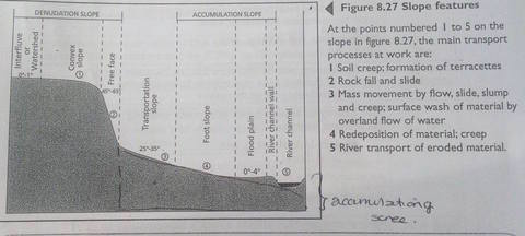
Caption: : Slope Features
Slide 10
Processes occurring in the channel KQ1
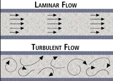
Flow: Flow is dependant on gravity, which causes it to flow downstream and the frictional resistance that the water has with the bed and bank. The amount of energy a river has os affected by the volume of water in the channel and the shape of the channel. There are two types of flow:
Turbulant: rough, chaotic, eddying. It contributes to depositional landforms. Conditions needed includes complex channel slopes such as meandering pools and riffles. High velocities, cavitation [pockets of air explode under high pressure]
Laminar: its the movement of water in sheets. [laminae] It is common in groundwater and in glaciers as well as the lower course and bed. The conditions needed include shallow channels, smooth straight channels and low velocities.
Slide 11
Climate
Geological structure
Rock type
Vegetation
Relief
Slide 12
Factors KQ1
1. Climate
A hot wet climate enables the rate of chemical weathering to increase by 2-3 x for every 10 degree temperature increase. This creates a rounder slope, whereas slopes in arid environments are jagged or straight because of mechanical weathering.
Large temperature fluctuations cause the rate of physical weathering to increase
Heating and cooling and Freeze thaw weathering are both dependant on temperature fluctuations
Increased rainfall increases sheer stress on a slope, so mass movements are more likely to occur.
2. Geological Structure
Joints, bedding planes and pore spaces increase the amount of surface area susceptible to weathering so weathering rates increase
Limestone and sandstone both have many bedding planes
Granite has no bedding planes
Rocks with few lines of weakness e.g faults and joints can maintain very steep slopes and are unlikely to become unstable.
An example of rock like this includes quartzite
Slide 13
Factors continued KQ1
3. Rock Type:
Mineral composition effects a rocks susceptibility to weathering.
A mineral easily weathered by carbonation is calcium carbonate (calcite) Which weathers to form bicarbonate ions in solution. This mineral is common in limestones.
A mineral easily weathered by hydrolysis is feldspar; which weathers to form kaolinite, a mineral commonly found in granites.
Quartz is an example of a mineral not easily weathered.
Rocks containing lots of clay are liable to causing slumping/ landslides as a mass movement, especially if overlain with a more permeable rock such as sandstone
valley sides that have been subject to slumping and landslides often have a stepped in profile
The Tees- Exe line is an imaginary line running from the River Tees to the River Exe. To the north and west are old, hard resistant rocks such as granite and basalt. To the south and east are younger, weaker rocks such as clay and chalk.
Slide 14
Factors continued... KQ1
4. Vegetation
decomposition of organic matter in the soil can increase the acidity of the soil
a decrease in soil pH can increase the rate of chemical weathering.
roots and plants through biological weathering can help open rocks and increase the surface area susceptible to weathering.
vegetation cover can reduce sheer stress by binding sediment together , it can also increase sheer stress by increasing soil moisture content.
5. Relief and Aspect
North facing slopes are cooler in the northern hemisphere so they will have slower rates of chemical weathering
High altitudes are colder, this increases the likelihood of physical weathering
Higher and steeper slopes are more prone to mass movements because of gravity.
A river at a base of a slope means that the slope above is more prone to mass movement due to erosion.
Slide 15
Processes occuring in the channel KQ1
River channel energy increases downstream because of
river discharge increases (River discharge- the amount of water flowing in the stream expressed as a volume of flow down a channel, it is measured in cumecs [cubic metres per second]
friction between water and the channel bed and banks decreases (as the channel becomes wider, deeper and smoother)
Erosion: [removal of the river bed and banks] - Critical Erosion Velocity: as flow increases CEV point s reached when there is a balance between moving and resisting frictional forces.Erosion depends on whether the river has enough energy to overcome friction and turn its energy towards erosion. Erosion happens when a particle becomes part of the streams load, when it is entrained (in motion). For this to happen, particles must be eroded, or dropped into the stream from higher up in the slope. The eroded sediment in 3 ways:
Vertical erosion: that deepens the stream channel. Corrasion (abrasion) is most important
Lateral erosion: that increases channel width. Hydraulic Action is the most important if bed/banks are made from unconsolidated material
Headward erosion: that increases the length of the channel e.g spring sapping and gully erosion.
Slide 16
Processes occurring in the channel KQ1
Erosion continued: Erosion increases as the river heads downstream because the channel becomes smoother and because the river has more energy so it's able to redirect a lot of it towards erosion. The four types erosion occurring in the river channel are CASH. Corrasion- (otherwise known as abrasion) its the wearing away of the bed and bank by the load carried by the river as it's thrown at the sides.Attrition- wearing away of eroded material that is being transported by the river. The eroded material is thrown at each other and creates smaller, rounder particles. Solution- is the removal of chemical ions, especially calcium. Its very effective, especially on chalk and limestone. Hydraulic Action- it is the force of air and water on the sides of rivers and in cracks. Factors that affect erosion: - Load: the heavier and sharper the load, the greater the potential erosion- Velocity: the greater the speed the greater the erosion- Gradient: increased gradient leads to greater erosion- Geology: the weaker and more unconsolidated material that there is, the greater the erosion. - pH: the more acidic the= more erosion - Human Impact: deforestation, dams and bridges interfere with natural flow and increase erosion.
Slide 17
Processes occurring in the channel KQ1
Transportation: movement of eroded material carried by the river. There are 4 ways of transportation, SSST. Solution: in areas of calcareous rock, material is carried in solution. It is the dissolved load. Suspension: the transportation of smaller particles [silt and clay] are carried in suspension. It is the suspended load. Saltation: the transportation of smaller pebbles via bouncing. They are part of the bed load. Traction: the transportation of larger pebbles or boulders as they are rolled along the river bed as the bed load. Sediment Yield is the amount of material debris carried by water. The factors affecting it include: high relief, erodible sediment, tectonic activity, erosive storms [tropical cyclones], vegetative cover, intense human activity. Deposition: occurs when a river looses energy for example because of: - a decrease in volume of water- shallowing in gradient as it decreases the velocity and gradient - an increase in friction between water and channel - human obstructions such as dams
Slide 18
Landforms created by the processes KQ1
Landforms created by erosion:
Mouth- A river
mouth is the part of a river that flows into a lake, reservoir or ocean. As a
river flows, it picks up sediment from the river bed, eroding banks, and debris
on the water. The river mouth is where much of this gravel, sand, silt, and
clay—called alluvium—is deposited. When large amounts of alluvium are deposited
at the mouth of a river, a delta is formed.
V shaped Valleys-
V-Shaped
valleys are found in the upper course of the river and are a result of both
erosion by the river and weathering. V-Shaped valleys are deep river valleys
with steep sides that look like a letter V when a cross section of them is
taken, hence the name. They’re found in the upper course because this is where
the river has the greatest gravitational potential energy and so the greatest
potential to erode vertically. It does so during periods of high discharge.
When the river’s discharge is high, it is able to transport its large bedload
by traction eroding the river’s bed and valley by corrasion, deepening it. Not
much lateral erosion takes place so the channel and valley remains relatively
narrow.As the channel and valley deepens the sides of
the valley are exposed and become susceptible to weathering. The valley’s sides
also undergo mass movements resulting in large volumes of material falling into
the river’s channel, adding to its erosive power and causing the valley sides
to take up a V shape. The steepness of the valley sides and whether the valley
actually looks like a V is dependent on the climate, vegetation and rock
structure among things. In cold, wet climates, freeze thaw weathering is
abundant and rainwater can act as a lubricant, aiding mass movements.
Vegetation can impede mass movements because it will help bind the soil. If the
valley is composed of hard rock the valley sides will be very steep because
they won’t be weathered easily.
Graded stream profiles
Interlocking spurs-
Interlocking
spurs are the outcrops of land along the river course in a valley.
A
number of natural forces form gorges. The most common is erosion due to streams
or rivers. Streams carve through hard layers of rock, breaking down or eroding
it. Sediment from the worn-away rock is then carried downstream. Over time,
this erosion will form the steep walls of a gorge. The flooding of streams or
rivers increases the speed and intensity of this erosion, creating deeper and
wider gorges.
Slide 19
Waterfalls-
waterfalls
form as streams flow from soft rock to hard rock (alternating bands). This
happens both laterally (as a stream flows across the earth) and vertically (as
the stream drops in a waterfall). In both cases, the soft rock erodes, leaving
a hard ledge over which the stream falls.Waterfalls
commonly form where water rushes down steep hillsides in upland areas. They are
typical of the upper valley, but can be found in the rivers lower courses where
the process of rejuvenation creates enough potential energy for vertical
erosion to recommence closer to the rivers mouth. The height and number of
waterfalls along a stream or river depends upon the type of rocks that are
being eroded by the water. This typically occurs in areas where alternating
bands of bed rock, made up of varying levels of resistance, form the bedrock.
Some types of rocks (shale, for example) wear away more easily than others
(such as sandstone or limestone).As the
river or stream wears away the weak rocks, they travel across the surface of
stronger rocks. These more resistant rocks become the capstones to waterfalls.
The number and thickness of these stronger rock units in a vertical sequence of
rocks controls how many water falls there are and how much vertical drop there
is on each waterfall.The water
flows over the overhang and creates a plunge pool in the soft rock below. As
the water hits the plunge pool it will erode it by both hydraulic action (the
force of the water against the bedrock) and by abrasion (where the material
carried by the river acts like sand paper against the riverbed) (3). Eventually
the overhang will collapse due to the erosion of the soft rock beneath it. The
waterfall then retreats up stream (4). This creates a steep, gorge-like valley.Waterfalls
develop when a change of lithology (rock type) takes place along the river’s
course resulting in differential erosion. When the rock type of the river’s
channel changes from a resistant rock to a less resistant one (e.g. granite to
limestone), the river erodes the less resistant rock faster producing a sudden
drop in the gradient of the river with the resistant rock being higher up than
the less resistant rock. As the river flows over the resistant rock, it falls
onto the less resistant rock, eroding it and creating a greater height
difference between the two rock types, producing the waterfall. When water
flows over the waterfall it creates a plunge pool at its base and the
splashback from the falling water undercuts the resistant rock. The unsupported
rock is known as the cap rock and it eventually collapses into the plunge pool
causing the waterfall to retreat upstream. Over thousands of years, the
repeated collapse of the cap rock and retreat of the waterfall produces a gorge
of recessionGorges-
A
number of natural forces form gorges. The most common is erosion due to streams
or rivers. Streams carve through hard layers of rock, breaking down or eroding
it. Sediment from the worn-away rock is then carried downstream. Over time,
this erosion will form the steep walls of a gorge. The flooding of streams or
rivers increases the speed and intensity of this erosion, creating deeper and
wider gorges.
Landforms created by the processes KQ1
Slide 20
Potholes-
Potholes
are round / oval shaped holes in the bedrock of a river bed.
They
are formed when sediment and other material carried by a river scours the bed.
Where depressions exist in the channel floor turbulent flow can cause pebbles
to spin around and erode hollows through abrasion/corraision. As the holes gets
bigger even bigger debris can become trapped in the pothole and this material
further supports erosion. Potholes are cylindrical holes drilled into the bed
of a river that vary in depth & diameter from a few centimetres to several
metres. They’re found in the upper course of a river where it has enough
potential energy to erode vertically and its flow is turbulent. In the upper
course of a river, its load is large and mainly transported by traction along
the river bed. When flowing water encounters bedload, it is forced over it and
downcuts behind the bedload in swirling eddie currents. These currents erode
the river’s bed and create small depressions in it. As
these depressions deepen, pebbles can become trapped in them. As a result of
the eddie currents, the pebbles drill into the depressions making them more
circular, wider & deeper. Pebbles will only be able to erode a river’s bed
though if the rock the pebble’s made of is stronger than the rock the river bed
is made of.
Knickpoints- A knick
point is a sharp break of slope in the smooth, concave long profile of a river.
It is usually marked by the presence of a waterfall (or a series of rapids). At
this point vertical erosion associated with rejuvenation is at its
greatest. The knick point retreats
upstream over time.
Landforms created by the processes KQ1
Slide 21
Landforms created by erosion and deposition:
Meanders- A meander
is a winding curve or bend in a river. Meanders are the result of both
erosional and depositional processes. They are typical of the middle and lower
course of a river. This is because vertical erosion is replaced by a sideways
form of erosion called LATERAL erosion, plus deposition within the floodplain.
In
low flow conditions straight river channels have bars of sediment on their
beds. Flowing water weavers around these bars of sediment. This creates deeper
pathways where most of the water flows called pools and shallow areas where
less water flows called riffles. This causes the river flow to swing from side
to side. Where the river swings towards the bank erosion causes undercutting.
On the opposite side of the channel where the velocity is lower material is
deposited. Therefore the river does not get any wider. Continued
erosion along the outer bank, as the result of hydraulic action and abrasion,
creates a river cliff or bluff. A point bar forms on the inner bank. This is a
gently sloping deposit of sand, gravel and pebbles. Meanders
are perpetuated through a process called helicoidal flow. As the surface flow
of water hits the outer bank it corkscrews, flows along the river bed then
deposits eroded material on the inner bank. Erosion is greatest beyond the middle of the
bend in the meander. This causes the meander to migrate downstream over time.
Ox Bow Lakes-
a
curved lake formed from a horseshoe bend in a river where the main stream has
cut across the narrow end and no longer flows around the loop of the bend.
Strong
erosion takes place on the outside bend of a meander while deposition takes
place on the inisde bend. As a result, the neck of a meander narrows. During
extremely high discharge (e.g., a flood), it’s more efficient for a river to
flow accross the neck of a meander rather than around it. When discharge
returns to normal levels, the river continues follow this new course. The
meander is left connected to the channel as a cutoff. Deposition eventually
separates the cutoff from the main channel leaving behind an oxbow lake. With
its main source of water disconnected, the lake eventually dries up leaving behind
a meander scar.
Landforms created by the processes KQ1
Slide 22
Landforms created by deposition:
Braided Channels-
Braided
channels develop in rivers with a lot of sedimentary load, a steep gradient and
where the discharge of the river changes regularly. When the volume of load
exceeds the river’s capacity or the discharge of the river drops, the river is
forced to deposit its load in the channel and islands of sediment (eyots) form.
Levees-
When a
river floods, it deposits its load over the flood plain due to a dramatic drop
in the river’s velocity as friction increases greatly. The largest &
heaviest load is deposited first and closest to the river bank, often on the
very edge, forming raised mounds. The finer material is deposited further away
from the banks causing the mounds to appear to taper off. Repeated floods cause
the mounds to build up and form levees. Levees aren’t permanent structures. Once the
river’s discharge exceeds its bankfull discharge1, the levees can be burst by
the high pressure of the water. Levees increase the height of the river’s
channel though, so the bankfull discharge is increased and it becomes more
difficult for the
Delta's-
Deltas
are depositional landforms found. When a
river meets a stationary body of water, its velocity falls causing any material
being transported by the river to be deposited. Deltas are made up of three
sediment beds that have been sorted by the size of the sediment. The bottom
most bed, the bottomset bed, is composed primarily of clay and some other fine
grained sediments. Clay is the main constituent because when clay meets salt
water a process called flocculation takes place where clay & salt particles
clump together (flocculate) due to an electrostatic charge developing between
the particles. This makes the clay particles sink due to their increased weight
producing the bottomset bed. The bottomset bed stretches a fair distance from
the mouth of the river as the fine sediments can be transported a reasonable
distance from the river’s mouth.The
foreset bed lies on top of the bottomset bed. The foreset bed is composed of
coarser sediments that are deposited due to a fall in the river’s velocity and
aren’t transported very far into the stationary body of water that the river
flows into. The foreset bed makes up the majority of the delta and is dipped
towards deep water in the direction that the river is flowing in.The
topset bed is, as the name suggests, the topmost bed of the delta. It too is composed
of coarse sediment but, unlike the foreset bed, the topset bed doesn’t dip,
it’s horizontally bedded.
Landforms created by the processes KQ1
Slide 23
- Arcuate deltas are shaped like a triangle (which is where the term delta comes from, the Greek letter delta Δ) and form when a river meets a sea with alternating current directions that shape the delta so that it looks like a triangle.
- Cuspate deltas are vaguely shaped like a V with curved sides. Cuspate deltas form when a river flows into a sea with waves that hit it head on, spreading the deposited sediment out
Bird’s foot are shaped like a bird’s foot. They extend reasonably far into a body of water and form when the river’s current is stronger than the sea’s waves. Bird’s foot deltas are uncommon because there are very few areas where a sea’s waves are weaker than a river’s current at the mouth of a river where the river meets a body of water with a lower velocity than the river (e.g. a lake or the sea).
Floodplains-
The
floodplain is the area that a river floods onto when it’s experiencing high
discharge. When a river floods, its efficiency decreases rapidly because of an
increase in friction, reducing the river’s velocity and forcing it to deposit
its load. The load is deposited across the floodplain as alluvium. The alluvium
is very fertile so floodplains are often used as farmland.
The width of a floodplain is determined by the
sinuosity of the river and how much meander migration takes place. If there’s a
lot of meander migration, the area that the river floods on will change and the
floodplain will become wider.
Landforms created by the processes KQ1
Slide 24
CHANNEL FLOW: the flow of water in a river is the result of the balance between Force and Friction.
Force- e.g. gravity = provides stream energy. This is potential energy [as represented by the total relief of the drainage basin] which is converted into kinetic energy as the river flows downstream.
Friction- e.g. energy lost, mostly as noise and thermal energy. This may be 95% of the available energy and is used to overcome friction, represented by contact with
The remaining energy is used for erosion of the bed and banks, and the transport of sediment load and water. Because water flows as turbulent or laminar, the amount of energy needed to overcome friction depends on partly on which type of flow occurs, as well as the shape and roughness of the channel. Channel shape is measured by calculating hydraulic radius and channel roughness is measured using Manning's n.
Caption: : The two types of channel flow
Slide 25
channel variables kq1
Velocity [V] is the speed of water flow- distance travelled per unit of time
Discharge [Q] volume of water that passes through a cross section [A] per unit time. Measured in m3 s-1 [cumecs] Q= A x V
Channel Width [w] distance across the channel on the water surface
Channel Depth [d] height from water surface to stream bed [m] A mean of several measurements is needed because the bed is uneven.
Cross sectional area [A] calculated from [ w x mean d] (m)
Wetted Perimeter [P] the length of the channel margin [bed and banks] in contact with the water (m)
Gradient [S] Change in channel elevation per unit length of the channel (m-1)
Hydraulic Radius [R] cross sectional area divided by wetted perimeter
Manning's n is calculated using V= R 2/3 S1/2/n
Caption: : Manning's n formula used to describe the relationship between channel roughness and velocity. The higher the value of n the rougher the bed. Channel roughness causes friction, which in turn slows down the velocity of the water. Friction is caused by boulders, trees and other irregularities in the river bed and contact between the bed and the bank.
Slide 26
The Bradshaw Model KQ1
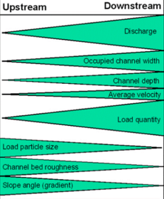
Caption: : The Bradshaw model describes the changes in a river's characteristics that occur between the source and the mouth.
Flaws with the Bradshaw model:
Scale- most geography fieldwork is done on a smaller scale than from source to mouth so unlikely to see sig. change
Reliability- when working at a small scale, the lines are unlikely to be as smooth, as changes across a few km are likely to be chaotic and irregular.
Flow- channel characteristics are formed under stormy circumstances so its unlikely results will show much
Data- hard to get enough results to show change
Drainage Basin Variations- lots of factors that create varied drainage basins which then effect stream characteristics and mean that the measured stream may not closely match that of the theoretical model
Slide 27
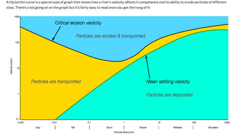
Caption: : Hjustrom Curve- There’s a few interesting things to note about the Hjusltröm Curve. The first is that clay sized particles don’t appear to have a mean settling velocity. This is because these particles are so fine that a river would have to be almost perfectly stationary in order for them to fall out of solution. In addition, the small particles seem to have an erosive velocity that’s the same as the velocity for larger particles. This is because smaller particles are cohesive, they stick together, making them harder to dislodge and erode without high velocities.
Hjulstrom Curve Graph KQ1
There’s two curves on the Hjulström Curve, a critical erosion velocity curve and a mean settling velocity curve. The critical erosion curve shows the minimum velocity needed to transport and erode a particle. The mean settling velocity shows the minimum speed that particles of different sizes will be deposited by the river. The shaded areas between the curves show the different process that will be taking place for particles that lie in those shaded areas.As an example, a river flowing at 10cms-1 will transport clay, silt and sand particles but will deposit gravel, pebble and boulder particles. Conversely, a river flowing at 100cms-1 will erode and transport large clay particles, silt particles, sand particles and most gravel particles. It will transport all but the largest of pebbles and will deposit boulders.The easiest way to read the curve is to draw a horizontal line from the velocity you’re trying to read and seeing which shaded area it crosses the particle size you’re interested in in. This will tell you whether that particle is eroded, transported or deposited at that velocity.
Slide 28
River channel Long Profiles KQ1
The long profile is the gradient along the channel from source to mouth. A typical long profile of a river includes: a similar geology throughout its length and if no climate or sea level changes it will be concave --> often called a graded profile. Traditionally, it was perceived that the concave shape of the long profile was due to the fact that near the source theres more gradient, so more velocity was needed to transport large boulders and cut down. Downstream smaller particles were deposited due to the lower velocity on a gentler gradient, and the middle zone the transportation zone. Now the explanation involves looking at the relationships of energy in the channel:
discharge increases downstream- more energy- more ability to transport more
increased discharge- given velocity can be maintained on gentler slope
discharge increases faster than sediment transport downstream as excess capacity so excess energy in stream which can be diverted for erosion + transportation
grain size decreases downstream
decrease in gradient but no decrease in velocity
Caption: : Graded profile [idealised] into how it actually changes
Slide 29
The Long Profile Continued KQ1
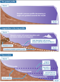
Irregularities in the long profile: It is rare for a LP to be perfectly
concave, and so the majority of LP are stepped. This is partly due to the fact
that the formation of a graded profile takes many thousands of years, and many
things can happen during that time to inhibit the formation of a perfectly
concave profile. For example, for the last 2 million years, sea level has
fluctuated eustatically because of the growth and decay of ice sheets; as a
result, land level has changed isostatically.
When there is a relative fall in sea level,
there is an extra input of potential energy to the river system because there
is now greater relief. Downcutting will work headwards from the coast, and a
knickpoint [local steepening of the profile] will form] At times this
knickpoint will be obvious in the rivers LP, especially when waterfalls and
rapids are present. If downcutting is rapid, meanders may be incised; terraces will
be left in the river cuts down into a floodplain. This is called REJUVENATION.
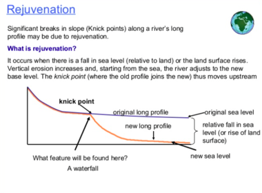
Caption: : Rejuvenation Process
Slide 30
Other reasons for 'stepping' of the LP: KQ1
Geology: a resistant bed prevents downcutting. If the bed
is horizontal, the gradient will be gentle, if the bed is tilted upstream, a waterfall
will be formed. Lines of weaknesses such as faults and joints speed up downcutting,
resulting in rapids and or a gorge.
Former Glaciation: glaciers more effective agents of erosion + transportation than rivers. e.g. On the s. side of Snowdon, glaciers of different sizes have created three distinct steps in its graded LP, each of which correlating with a hollow formed by a glacier. Glaciers can also leave behind deposits that locally steepen the profile.
Lakes and Reservoirs: these flatten the profile upstream of the lake as GPE is effectively decreased to the local base level. Downstream is likely to have a more steep graded profile as a result of excess of energy in the river which will have no load to carry as lakes act as sediment traps. This is called clear water erosion.
River Management Schemes: e.g. channelisation- usually straightening of a river, steepens the LP because the river takes a more direct route to the sea.
Confluences: the increase in discharge may result in local downcutting immediately downstream because of the greater quantity of water for erosion.
Tectonic Movements: uplift will cause a steepening of the profile, so greater GPE, subsidence may cause the profile to become gentler.
Slide 31
The River Load KQ1
The river load is categorised by size (these different particles can be seen on the Hjulstrom curve) The amount of load inside a river can be influenced by number of factors:
Geology of the rock- in hard rock rivers the load yield is much smaller because it takes more energy to erode. [physical factor]
Size of the drainage basin- the larger the DB the more tributaries it will have, so there is more capacity for higher amounts of load [physical factor]
Relief- drainage basins with less steep relief have lower gravitational potential energy to erode the channel with. So there is less erosion, and less load. [physical factor]
Deforestation- less trees and vegetation to bind the soil together, so the soil is easier to erode and there is more load. [Human factor]
Urbanisation- the construction of dams and other features decrease sediment yield as it traps the load inside it. [human factor]
Formation of landforms- high load = more levees and deltas formed. Also more abrasion and attrition can take place--> more load.
Slide 32
Sea Level Change KQ1
Eustatic change is when the sea level changes due to an alteration in the volume of water in the oceans or, alternatively, a change in the shape of an ocean basin and hence a change in the amount of water the sea can hold. Eustatic change is always a global effect. During and after an ice age, eustatic change takes place. At the beginning of an ice age, the temperature falls and water is frozen and stored in glaciers inland, suspending the hydrological cycle. This results in water being taken out of the sea but not being put back in leading to an overall fall in sea level. Conversely, as an ice age ends, the temperature begins to rise and so the water stored in the glaciers will reenter the hydrological cycle and the sea will be replenished, increasing the sea levels. Increases in temperature outside of an ice age will also effect the sea level since an increasing temperature will cause the ice sheets to melt, putting more water in the sea. The shape of the ocean basins can change due to tectonic movement. If the ocean basins become larger, the volume of the oceans becomes larger but the overall sea level will fall since there’s the same amount of water in the ocean. Conversely, if the ocean basins get smaller, the volume of the oceans decreases and the sea level rises accordingly.
Isostatic sea level change is the result of an increase or decrease in the height of the land. When the height of the land increases, the sea level falls and when the height of the land decreases the sea level rises. Isostatic change is a local sea level change whereas eustatic change is a global sea level change.During an ice age, isostatic change is caused by the build up of ice on the land. As water is stored on the land in glaciers, the weight of the land increases and the land sinks slightly, causing the sea level to rise slightly. This is referred to as compression. When the ice melts at the end of an ice age, the land begins to rise up again and the sea level falls. This is referred to decompression or isostatic rebound. Isostatic rebound takes place incredibly slowly and to this day, isostatic rebounding is still taking place from the last ice age.Isostatic sea level change can also be caused by tectonic uplift or depression. As this only takes place along plate boundaries, this sort of isostatic change only takes place in certain areas of the world.
Slide 33
The River Severn Case study: KQ1
The river severn is sourced in the Plyn Limon Hills in central Wales. There is often heavy rainfall and the hills provide a high altitude of over 800m. Its mouth is the Bristol Channel in England. It has two main tributaries: the Avon and the Severn. \Landforms along the River Severn: Interlocking spurs and v shaped valleys, waterfall and gorges, incised meanders and meanders, pot holes, ox bow lake, river terrace, levees, floodplain, mudflats. The RS is the 3rd largest river in Britain, with a catchment of 11500km2. Floodwater storage is provided by two major reservoirs called the Lake Vrynwy and Clywedog.
The Severn Upper Course: The source of the River Severn is in moorland in mid-Wales. The area receives excessive rainfall due to depressions from the Atlantic. The Severn swiftly grows and forms a V-shaped valley. The river transports a large load, which allows rapid erosion to take place. Waterfalls and gorges have been formed in the upper course. As the gradient decreases, meanders and oxbow lakes can be found. As the river nears the lower course, flooding is a threat.Lower and Estuary: As the River Severn nears the sea, the floodplain is wide and there is little high ground to build on. People have built on the floodplain since Victorian times and flooding is a constant threat. The Severn ends in a wide estuary which has a high tidal range. Mudflats are found here. The deep estuary is ideal for industry as large boats can navigate easily and the flat land at the side is cheap and plentiful.
Slide 34
The River Nile Case Study
Slide 35
The drainage basin as a multi resource
A river drainage basin is the catchment area within which water is supplied by precipitation / underground sources and is then transported out as a stream. It is also sometimes called a catchment. Drainage basins are used for human activities like: - to provide a source of water - opportunities for industrial development. - opportunities for residential development - fertile site for agriculture - for transportation - a source of power - recreation and leisure - flood defence through flood plains - a conservation value.
land use along the river severn:
residential
infrastructure
services
agriculture
The variety in human land use can be due to:
scenery
history of the area
flat land
fertile soils
river as transport
water supply
Slide 36
Land uses of Upper, Middle + Lower
LAND USE OF THE UPPER COURSE OF THE SEVERN: - tourism - farming - reservoirs- high rainfall provides water for towns lower down. V shaped valleys are fairly easy to dam and provide deep reservoirs. - Hydro Electric Power- HEP: LAND USE OF THE MIDDLE COURSE OF THE SEVERN: - settlement- towns built on flat land - farming- on flat valley floors where soils + weather are better - angling- good source of income for landowners, especially in salmon rivers. -transport- -Tourism- farmers provide simple accommodation [B +B, caravan, camping] to supplement their income. Middle course location provides tourists with access to both uplands and lowlands.
LAND USE OF THE LOWER COURSE OF THE SEVERN: - settlement- large towns or cities 9though flooding can be a problem) - farming- rich, fertile alluvial soils provide a wide range of farming opportunities with dairying close to settlements. -transport- -industry- -transport- is straightforward. Large towns provide labour.
Slide 37
Conflicts of land use in River Severn
Conflicts can be:
Between different land uses/ human activities: e.g. River Nile: the building of the Aswan Dam in southern Egypt has enabled flow to be regulated and so prevent flooding. However, its also effected arable land as its deprived it of silt [which acts as a natural fertiliser when the river is flooded- in the past] downstream of the dam.
Within the same land use or activity: e.g. the River Exe- recreation in the river sees conflicts between anglers and canoeists; there are even more water based conflicts further downstream.
Conflicts may occur because:
One activity impacts another e.g. wildlife is disturbed by motorboats
Two (or more) activities compete to use the same water e.g. irrigation for agriculture and water supply for human consumption
An activity changes the nature of water for another user e.g. industrial water pollution and drinking water
water is a fluid so moves from one area to another with its contents e.g. fish.
Slide 38
Human activity in the River Severn
water supply- R. Severn is longest river in Britain, with a catchment of 11500km2 and a population. Predominantly rural
Slide 39
River Nile Drainage Basin
Slide 40
KQ3: Hydrographs
Slide 41
July 2007 Floods and Impacts
Slide 42
Factors that make places flood vulnerable:
Slide 43
Shrewesbury Flood Vulnerability
Slide 44
Urban Hydrology
Slide 45
KQ4:
Want to create your own Slides for free with GoConqr? Learn more.