
Karteikarten
Rivers
Karten in diesem Stapel (61)
- 1How does rain form at the start of the hydrological cycle?> Evaporation from land and sea causes water vapour to rise
> Transpiration causes water vapour to rise
> wind moves water vapour inland
>water vapour condenses to form clouds then falls over land as precipitation - 2What is infiltration?When water soaks into soil
- 3What is percolation?When water moves vertically down through soil and rock
- 4What is throughflow?When water in soil flows downhill
- 5What is groundwater flow?When water in rocks flows downhill
- 6What is surface runoff?When water flows overground
- 7What is channel flow?Flow of water in a river
- 8What is the type of storage when water is held in a river?Channel storage
- 9What is the type of storage when water is stored underground in soil and rock?Groundwater storage
- 10What is interception storage?When water lands on plants and leaves and doesn't hit the ground
- 11What is surface storage?When water is held in lakes, reservoirs and puddles
- 12How does the hydrological cycle end?water ends up in sea again where it evaporates and starts the cycle again
- 13Now, briefly sum up the hydrological cycle> evaporation and transpiration
>precipitation
>flows and transfers
>storage
>sea - 14What is a drainage basin/ river basin?An area of land drained by a river and its tributaries
- 15Name the river basin inputPrecipitation
- 16Name the river basin flows> Surface runoff
>infiltration
>percolation
>groundwater flow
>channel flow
>throughflow - 17Name the river basin stores>channel storage
>groundwater storage
>interception storage
>surface storage - 18Name the river basin outputs>evaporation
>transpiration
>river flow into the sea - 19What is the watershed?boundary separating different river basins (usually high ridges of land)
- 20What is a tributary?A smaller river which joins onto the main river (e.g. stream)
- 21What is the source?Where the river starts
- 22What is a confluence?Where two rivers join
- 23What is the mouth?Where the river flows into the sea or a lake
- 24Describe mechanical weathering (e.g. freeze thaw)-Mechanical weathering doesn't change chemical composition of rock
-water gets into cracks and expands when freezes putting pressure on rock. Repeated process causes cracks to widen and bits to break off - 25Describe chemical weatheringchanging rocks chemical composition causing it to weather
(acid rain causes some rocks to dissolve in rainwater) - 26Describe biological weatheringbreak down of rocks by living things (e.g. roots or moles)
- 27Describe the upper course of a river-V shape valley
- steep sides
- shallow channel
-Steep gradient downwards
- interlocking spurs
-fast flowing
-waterfalls - 28Describe the middle course of a river- gently sloping valley sides
- wider deeper channel
- medium flow
-medium gradient downwards
-meanders
-oxbow lakes - 29Describe the lower course of a river-very wide flat valley
-wide deep channel
-gentle gradient
-slow flow
-flood plains
-deltas - 30Name the 4 processes of erosion- hydraulic action
- corrasion/ abrasion
-attrition
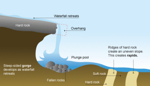
-corrosion - 31What is hydraulic action?force of water breaking rocks particles away from sides of river channel
- 32what is corrasion/ abrasion?eroded rocks in river scrape and rub against channel causing it to wear away
(most common) - 33what is attrition?eroded rocks in river ash into each other causing further erosion
- 34what is corrosion?River water dissolving some types of rock (e.g. chalk)
- 35Name the 4 different methods of transport in a river-traction
-saltation
-suspension
-solution - 36What is traction?large boulders pushed along river bed by force of water
- 37what is saltation?smaller pebbles being bounced along river bed by force of water
- 38what is suspension?small particles suspended in water being carried along
- 39what is solution?soluble materials being dissolved in water and carried along
- 40what is deposition?when a river drops the eroded material its transporting
- 41When does deposition happenwhen a river slows down because...
-volume of water in river falls
-amount of eroded material in river increases
-water is shallower (e.g. inside of bend)
-river reaches its mouth - 42How do waterfalls and gorges form (draw a diagram)
- 43How do interlocking spurs form?In upper course of river most erosion is vertically downwards
this creates steep v shaped valleys
rivers aren't powerful enough to erode sideways into the steep valleys so have to wind round creating interlocking spurs - 44How do meanders form?- current faster on outside of bend than inside of bend
- more erosion takes place on outside of bend forming river cliffs
- eroded material is deposited on the slow and shallow inside of the bend forming slip off slopes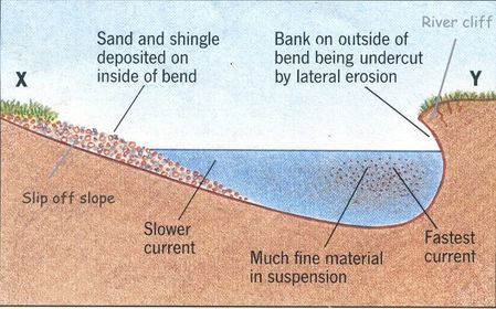
- 45How do ox- bow lakes form?- erosion causes outside of bends to get closer until only small bit of land left in between
- river breaks through the land and river flows through shortest course
- deposition cuts off meander forming ox- bow lake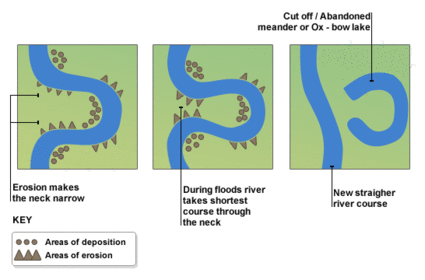
- 46What are floodplains? How are they formed?wide valley floor on either side of river
formed when river floods and deposits material
formed when meanders migrate making it wider
formed by deposition onto slip off slopes - 47What are levees? How are they formed?Natural embankments (raised bits on edge of river channel)
formed when river floods and deposits material on floodplain- material most heavily deposited on edge of river causing levees to build up - 48What are deltas? How are they formed?low lying areas where a river meets the sea or lake
formed when river slows down and so material is deposited - 49What is the lag time in a storm hydrograph?time between peak rainfall and peak river discharge
- 50what is the rising limb in a storm hydrograph?the increase in river discharge as rainwater flows into river
- 51what is the falling limb in a storm hydrograph?decrease in river discharge as river returns to its normal level
- 52what causes the lag time? (time taken for rainwater to get into the river)- surface run off
- infiltration - 53Name factors that that increase a rivers discharge- high rainfall
- intense rainfall (not time for infiltration = surface run off)
-impermeable rock (surface run off)
previously wet conditions (soil already saturated = surface run off)
-steep slopes = more run off
-less vegetation = less water intercepted
= less water slowed by roots in ground - 54Name factors that decrease a rivers discharge- low rainfall
- light rainfall
- permeable rock
- previously dry conditions
- gentle slopes
- more vegetaion - 55What would be the difference between a storm hydrograph for an urban area and a rural area and why?Urban- steeper because of impermeable materials
Rural- gentler because more vegetation, more reservoirs - 56name some physical causes of flooding- prolonged rainfall- soil becomes saturated > more surface run off > increase in river discharge
- heavy rainfall - no time for infiltration > lots of runoff > lots of discharge
- snowmelt- lots of water goes into river all at once increasing discharge rapidly
-geology- if river in area of permeable rock (like limestone) less chance of flooding
-if river in area of non permeable rocks (like clay) more risk of flooding - 57name some human causes of flooding- deforestation (trees intercept water which then evaporates)
(deforestation causes soil erosion as no roots to hold soil together so soil gets deposited in river bed raising the river bed meaning it has less capacity for holding water)
- urbanisation (impermeable materials such as concrete for buildings and tarmac for roads increases surface run off) - 58state some impacts of flooding- spread of disease from contaminated water supplies
- buildings damaged
-homelessness
-losing jobs
-worse in ledcs than medcs - 59state some hard engineering flooding management strategies- Dams and reservoirs
(good for drinking water or hydrological power)
(bad because expensive releases fertility of farmland down stream)
- Channel straightening
(good because water moves out of area quicker)
(bad because flooding may happen further down stream)
- Man made levees
(good because river can hold more water and pretty cheap)
(bad because if levees burst flooding Is worse) - 60state some soft engineering flooding management strategies- flood warnings
(good because impact of flooding is reduced)
(bad for LEDCs with no communications
- preparation
(good because impact of flooding reduced buildings protected and people prepared)
(bad because doesn't guarantee safety could give people a false sense of security)
- flood plain zoning
(good because impermeable surfaces aren't created in flood zone)
(bad because expansion of urban area limited) - 61State why soft engineering is more sustainable than hard engineering- reserves resources for future generations
- cheaper to build and maintain (good for LEDCs)
- less bad for the environment
Informationen
- Beschreibung
- Karteikarten am Rivers, erstellt von hollybb02 am 29/04/2015.
- Erstellt von
- hollybb02
- Aufrufe
- 1
- Bewertung