Description
|
|
Created by jessmitchell
over 11 years ago
|
|
Page 1
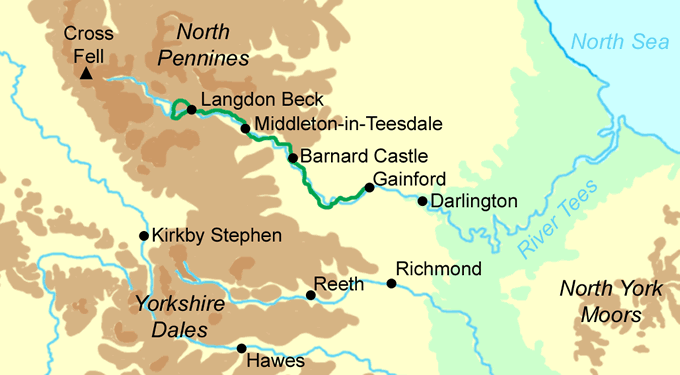
Geography case study- The River Tees, North East England
Source: Cross FellMouth: Middlesborough/TeesideLength: 128kmHeight at source: 750mHeight at mouth: 0mIt drains an area of 710 square miles.
Upper course features- in the upper course of the Tees, mainly the Pennine Hills, the valley is V shaped and very steep sided and can be up to 550 metres tall.- There are also interlocking spurs as the river cuts through the valley-There is high run off as steep V shaped valleys of impermeable rock exist here- There is also a high rainfall and therefore a good water supply. The river has many tributaries here.
High force waterfall ..is on the River Tees, and is one of the most impressive waterfalls in England. Here the River Tees plunges some 20 metres into the foaming plunge pool before continuing its journey through the around 700m long gorge. It is located just east of the Pennine Hills.
Upper CourseChannel characteristics- river is winding and very bendy, fast flowing and has little depositionValley characteristics- the relief and the height of the land are high and steep in comparison to later in the river's course
Lower course featuresMeanders- a few kilometres to the south east of Darlington, very sinuous meanders can be found which mainly cut through fertile farm land. Some meanders even double back on themselves. The river is much longer than it looks due to these meanders. They may turn into Oxbow Lakes in the future if the 'neck' of the ones which have doubled back erodes away.
Flood Plains & LeveesThe land is very flat in the lower course, which means there is a flood risk, but embankments and levees are in place to protect against flooding.
Estuary & Lower CourseChannel characteristics- 250m wide, up to 1km at the mouth. Relatively straight and lots of mudflats and silt being deposited as the river slows downValley characteristics- very flat, only between 1m and 10m above sea level. Land used for heavy industry like oil refineries.
Case Study- Migration within England
About 10% of the population in England move house each year but most people stay within the same region. However a significant number of them move to other parts of the country. Coastal areas have the biggest gain from internal migration and cities are the biggest losers
The southwestis a popular area to move to. Migrants may be moving to work in cities such as Bristol or moving to live in the countryside or by the coast. Many people choose to move to the south coast when they retire
key: green - positive migration (gaining red - negative migration (losing)
The southeast(excluding London) is the most popular area to move to because this is where the greatest number of jobs is available, either by travelling into London or in the region itself. Some migrants move from other parts of the UK and some move from London to the south east and commute to work.
The northeast, northwest and west midlandshave all experienced population decline in the last decade. This is because these areas have sen increases in unemployment as manufacturing industries have closed and because there are not so many job opportunities here, especially in the recent recession.
East Anglia- is an area which has more people moving into it than out
Londonis the area with the highest out migration. Although there are lots of jobs available in london it is also an expensive and busy place in which to live. Many people decide to move to the surrounding areas to live, especially if they have a family, and retired people may also choose to live elsewhere.
W
Why do people move?- most people move to find work, so areas with high unemployment tend to lose population and areas with more jobs or better paid jobs gain population.-Older people often choose to move away from large cities to the countryside when they retire, or a coastal area. This is counter urbanisation- many young adults move away from home to go to university or to find a job- as people earn more money they may choose to move out of towns and cities and live in rural areas and commute to work. This is also counter urbanisation.- Areas losing population like London & the north may become unattractive to new businesses and provide fewer opportunities for people living there.
Managing population changeThe UK government tries to make sure that migration is not causing problems within the country and that some areas do not become much more prosperous than others. The government supports the least prosperous areas by giving grants and loans to businesses and investing in infrastructure like transport. This can help bring jobs to the area.The UK government is also moving some of its own workers away from London and the southeast to other centres like Manchester, Leeds and Newcastle
Case Study- Goat Aid in Babati Province, Tanzania
An aid project in an LEDC and its sustainability
Goats are given to local farmers by a UK charity called Farm Africa. The costs of the scheme are breeding and transporting the goats, alongside the training of people to look after them.
Farm Africa meets with the villagers receiving the goat aid before administering them, in order to discuss their needs, so the process is shared.
Benefit 1)A dairy goat provides up to 300l of milk a year which is protein and calcium rich which can help prevent malnutrition for the people in the village. The goats can also be sold on to other people
skills taught about goat rearing can be passed around the community or from one generation to another, hence socially sustainable. Farm Africa also supports agricultural education in schools.
--->
--->
Benefit 2)When a goat reaches the end of its life it can be killed for the meat, which further helps prevent malnutrition, which is an issue in Africa as a whole.
Benefit 3)The hide of the goats can be made into leather products and sold onto others. This means that people selling the hide will be able to have a better health, as well as having enough money to attend school or work regularly, this increasing their income and having a better standard of living. This is both socially & economically sustainable as people have a reliable income and and people can access better education & skills for their future
Benefit 4)Goats also provide manure with reduced the need for artificial fertilisers and increases crop yields. This is environmentally sustainable as it is better for the environment to use natural products as they do not cause damage.
Benefit 5)Goats also breed well and spare goats can be sold on to others or used to replace older goats that do not produce much milk, which is sustainable.
Benefit 6)They have a good survival rate in droughts too, as they can eat thorny bushes and weeds so they won't die quickly in the environment which would be unsustainable.
Negative 1)one negative is that too many goats cause overgrazing, which can destroy vegetation and increase soil erosion, thus damaging the natural environment & reducing crop yields in future. This is not sustainable.
Case Study- Pevensey Bay Sea Defence Scheme
Pevensey Bay is a low lying area in East Sussex that is vulnerable to coastal flooding. The use of heavy engineering methods to protect the area would not be suitable- because of the scenic and environmental value of the area.
Why does the area need protection?- longshore drift is removing increasing amounts of beach material-over 50km2 of flat land would be flooded if coastal defences failed-The Pevensey Levels is an environmentally sensitive area (SSS!) would be flooded with salt water if defences failed- There are over 10,000 properties with a number of caravan parks-The main coast road and rail links run along the coast
Beach replenishmentLongshore drift in the area means that beach material is constantly being lost. This material is replaced by dredging it on the seabed and then spraying it back onto the beach. This is carried out by a specially adapted boat which can come close to the beach at high tide. This is done in the summer months when there's less storms.
Beach reprofilingDuring the winter storms, destructive waves move the beach sediment down the beach towards the sea. This maakes the upper beach levels very low and liable to wave attack. Bulldozers are used to move the material back up the beach and reshape the beach so it has an even, gentle slope.
Beach recycling
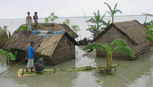
Case study- Flooding in Bangladesh - River Ganges
Causes-The meeting point of three huge rivers hugely increases the flood risk, as the River Ganges, Brahmaputra and Rover Meghna meet at a confluence very near to Dhaka, the capital of Bangladesh-70% of the total land is less than 1m above sea level which means there is nowhere for the water to drain to-Deforestation in the Himalayas increases the surface run off on the land, which leads to soil erosion and a higher level of silt in rivers, raising the river beds so less water can be held.-Rapid urban growth has added to the issues as urban populations have increased from 4% to 35% in 58 years.-Bangladesh is 80% flood plain and delta which makes it very susceptible to flooding-In India, the Ganges has been diverted for irrigation which means deposition of silt has increased and the capacity of the channel has decreased. In the rainy season, water is let through, causing flooding-Heavy monsoon rains cause summer flooding-Melting snow from the Himalayas adds to the volume of water in warmer months.
Facts-Bangladesh is surrounded on three sides by India & is located in South East Asia, on the Bay of Bengal and then the Indian Ocean-The current Dhaka population is 14 million, which has increased by 10 million over the last 30 years.
Effects-2.4 million farmers affected- cannot grow or produce crops of livestock, no money can be made for farmers livelihoods and will not be able to afford necessities to survive so people will die from starvation as no food is being made-130 million cattle killed- dead bodies of cattle infect the water supplies, making it dirty and unsafe to drink- so diseases like cholera spread, leading to deaths. No cattle can be used as food, more starvation and death & limited exports-11,000km of roads damaged- transport is made very hard so emergency services will struggle to help those in need and transport of goods for export/import will be much harder. Bangladesh will not be able to make money from exports to cope with the disaster-23.5 million people homeless- people with no homes will struggle to survive, exposed to disease & weather conditions, leading to death. Government pressure to help those suffering increases. People will have no money for a decent standard of living.
Short term flood relief-350,000 tonnes of cereal were bought by government to feed people-The UK government gave 21 million-more than 1million tonnes of international food aid supplies-the World Health Organisation appealed for £5.2 million to buy water purification tablets for up to 35 million people-The government gave free seeds to farmers.
Responses
Part of the Preparedness programmeCluster villages- a cluster village is a village that has been raised 2m above water level. Each village houses between 25 & 30 families. Helps by: houses and possessions will not be destroyed as water cannot reach them, and village will be safer generally as people are less at risk from flood water.Raised homestead-Individual homes are raised 2m above water level on earth banks. The earth banks are planted with grass to prevent erosionFlood shelter-around 2 hectares of raised land where people can bring livestock & each shelter has space for over 100 families & includes a community room & toilets.Rescue boats- Rescue boats are located around the area's most at risk from flooding and near to flood shelters.
Dhaka Integrated Flood protection projectOn the west side of Dhaka there has been a protection project put in place in order to protect the city from the annual floods. Embankments of earth were built to hold back the rising water. Slope protection was added to reduce erosion of the embankments. Huge storm drains were built which link back to rivers. Sluice gates have been built which are able to close channels when water rises.
the river tees
migration within england
Goat Aid/Farm Africa
PEVENSEY BAY
Flooding in bangladesh
Want to create your own Notes for free with GoConqr? Learn more.