
Karteikarten
Geography Theme 1
Karten in diesem Stapel (74)
- 1POPULATION DISTRIBUTIONNorth & South sparsely populated due to climate leading to infertile land because of permanent frost covering the ground. Around and in the equator densely populated (cities) because of the jobs, resources and quality of standard of living
- 2POPULATION EXPLOSIONRapid population increase that took place in the last 50 years
- 3LEDCsLess economically developed countries
- 4MEDCsMore economically developed countries
- 5INFANT MORTALITY RATEThe proportion of children dying at birth or before their first birthday
- 6FERTILITY RATEThe average number of children people in a country or region have in their life time
- 7OVER-POPULATEDWhen a country does not have enough resources to give all its people an adequate standard of living - due to a lack of clean water, droughts, loss of jobs, population growth, deforestation, natural diseases - TANZANIA
- 8UNDER-POPULATEDAn area where the number of people living in it is lower than the number that can be supported by the resources in the area - CANADA
- 9SPARSELY POPULATEDAn area (usually 1km squared) where few people live - Africa is an example
- 10REASONS FOR SPARSELY POPULATED AREASMountains, dense forest, unreliable water supply, poor soil, poor farming, desserts
- 11DENSELY POPULATEDAn area where a lot of people live (often a number of people per 1km squared)
- 12REASONS FOR DENSELY POPULATED AREASFlat land, lowland, open grassland, good farming, rich soils, job opportunities
- 13PANDEMICAn outbreak of an infectious disease that kills many people in a short amount of time due to the speed at which it spreads
- 14´ABC` SLOGANUsed in African countries to tell people ways in which they can avoid HIV/AIDS:
Abstinence, monogamous, contraception - 15ANTI-NATALIST POLICIESA policy that aims to control or limit the birth rate and so slow down the rate of population growth (doesn't stimulate it)
- 16ONE CHILD POLICYIntroduced in 1979 by communist party it stabilased the birth rate but didn't decrease it. It lead to an ageing and mainly male population, so in 2003 a 2 child policy was introduced (further info. in books)
- 17PRO-NATALIST POLICIESA policy that aims to stimulate the rate of population growth
- 18CARTE FAMILLES NOMBREUSESA popular strategy that provides benefits to families with 3 or more kids, benefits such as reductions on national train network and half-price fares on the Paris metro underground system
- 19AGE DEPENDENCYThe link between tha number of adults who work and earn money, and the number of youngsters and elderly who depend on their support
- 20NATURAL CHANGEBirth rate - death rate
- 21MIGRATIONThe movement of people, either voluntary or forced, from one place to another. It can be inside the country (internal) or fromone country to another (international - Senegal to Europe)
- 22INMIGRATIONThe migration of people into a country
- 23EMIGRATIONThe migration of people out of a country
- 24PUSH FACTORSThings that make people want to leave an area
- 25PULL FACTORSThings that attract people to a different area
- 26COUNTER-URBANISATIONThe movement of people from cities to the countryside
- 27ECONOMIC MIGRANTSPeople who migrate in search of a job and so a better life for them and their families. They often send money to their families and return home once they've earned enough money.
- 28ILLEGAL MIGRANTSPeople who enter a country unofficially without making themselves known to the authorities
- 29REFUGEESPeople who are forced to move. It is estimated that there are over 45 million refugees in the world right now that live in poor conditions
- 30BRAIN DRAINWhen qualified people leave in search of a better life.
The consequences of this are that there is no development, as qualified people leave, but a possible economic development in the future if they return - 31CENSUSAn official count of a country or region's population done by the government every ten years to collect data on the population. They are expensive, difficult to organise and the ability to read and write are required in order to answer the questions
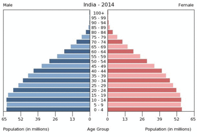
- 32AGE/SEX PYRAMIDDiagram used to display age/gender census data
- 33DIFFERENT POPULATION STRUCTURESBirth and death rates, chilhood and elderly groups vary in size depending on the stage of a country's economic development
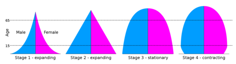
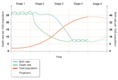
- 34—The demographic transition model shows population change over time. It studies how birth rate and death rate affect the total population of a country.
- 35POPULATION DISTRIBUTIONThe way people are spread throughout the Earth
- 36POPULATION DENSITYHow many people live in an area (usually one km squared)
- 37UNINHABITEDDescribes places where no people live
- 38REASON FOR POPULATION DISTRIBUTIONThe population distribution is uneven for many reasons, but mainly because there is twice as much land in the northern hemisphere as there is in the southern
- 39WHY PEOPLE LIVE WHERE THEY DOSome people don't have a choice, as some governments don't allow people to enter or leave the country. However most people have free choice and decide where they want to live in the basis of what's better for them
- 40EXTREME ENVIRONMENTA place with harsh and challenging conditions where organisms must adapt to be able to live in it. That's why in their mayority they are either inhabited or very sparsely populated
- 41CASH CROPSAny crop which can be eaily sold, such as wheat, groundnuts (peanuts) and cotton
- 42SOIL DEGRADATIONThe process of the soil becoming less fertile. It can happen in thre ways:
- Erosion, salinisation and leaching - 43EROSIONSoil eroded and carried away by strong winds and cattle over grazing
- 44SALINISATIONMinerals in the wáter build up in the soil, due to high evaporation rates, and cause it to become toxic to plants
- 45LEACHINGHeavy rain dissolves valuable plant nutrients and washes them downwards so that plant roots can't reach
- 46DESERTIFICATIONThe process throgh which semi-ari environments become desert-like. It is not the spread of desserts but the consequence of their presence, their effect on nearby areas
- 47DESERTIFICATION, A GLOBAL PROBLEM- 1/3 of the world's total land área desertified or under serious thread
- 20% of the world's populationunder threat
- 850 million people affected - 48SETTLEMENTAny place, ranging in size from a hamlet to a mega city, where people live and work
- 49SITEThe land on which the first part of the settlement is built
- 50DISPERSED SETTLEMENTIndividual buildings are widely scattered over a rural area and linked by a network of tracks and minor roads
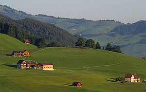
- 51LINEAR SETTLEMENTLong and narrow, with most of the buildings along a road, river bank or shoreline
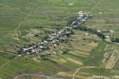
- 52NUCLEATED SETTLEMENTBuildings tightly clustured around a road junction, church or bridge. They are the same distance accross in different directions
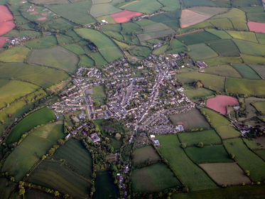
- 53FUNCTIONSBasically trade and services
- 54WHY ARE THERE MORE HAMLETS THAN TOWNS OR CITIES?Towns and cities are bigger, so not as many fit (there's not enough space). On the other hand, towns and cities have appeared more recently, so they might need a bit more time to catch up on number, in other words, a bit more time to build as many
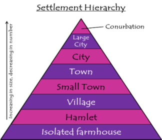
- 55SETTLEMENT HIERARCHYArranging settlements according to their population size or the services which it provides - normally same order as population size
- 56THRESHOLD POPULATIONThe number of people needed to support a business or service. Its size is closely linked to the needs of the particular activity
- 57WHEN TAKING THERSHOLD DATA YOU HAVE TO TAKE INTO ACCOUNT THAT...- Some communities are wealthier than others so fewer people are needed to make the service viable
- Not al people share the same interests or needs
- Different places = different preferences and traditions (French like hand-crafted bread so a baker's shop would be viable) - 58CATCHMENT AREA / SPHERE OF INFLUENCE- Minimum area from which enough people can be drawn to make the business viable
- It exists because each type and level of service has its own population threshold
- Are served by a business - 59SUBSISTENCE CROPSSome rural areas, such as Chembakolli (a village in southern India), grow crops to feed the locals (subsistence crops). Rice, onions, tomatoes and peppers are examples of this type of crop
- 60CASH CROPTea is an example of a crop grown to make money
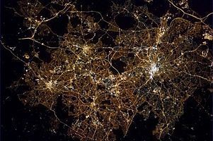
- 61CONURBATIONA very large built-up area formed by urban sprawl
- 62URBANISATIONAn increase in the percentage (proportion) of the world's population living in urban areas.
URBANISATION HAS BEEN GROWING FOR THE LAT 200 YEARS - 63LAND USE ZONESUrban areas which have different functions and characteristics to other nearby areas.
BOTH URBAN MODELS ARE BASED ON THE LOCATION OF LAND USE ZONES, WHICH HAVE IMPORTANT FUNCTIONS AND FACILITIES - 64LAND USE MODELSTheories which attempt to explain the layout of urban areas. It us used to simplify complex, real world situations, and make them easier to explain and understand.
- 65THE BURGESS MODELCentre = oldest part
Building spreads out from the middle so newest parts are on the edge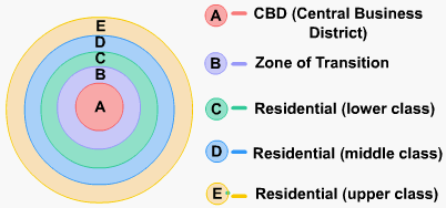
- 66THE HOYT MODELRecognises roads and railways as part of the city as well as the location of residential areas away from industrial development
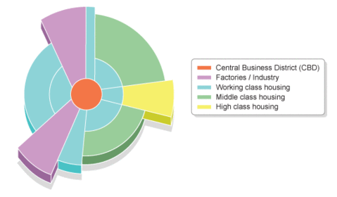
- 67WHY ARE THE LAND USE MODELS OUT OF DATE?- Old inner city areas have redeveloped and original functions hae changed (retail parks replace poor-quality housing)
- Roads have attracted industries and houses away from busy inner areas
- Oldest part of town is usually closer to one side of the urban area, not in centre - 68TRANSECT ACROSS A TYPICAL CITY IN A MORE ECONOMICALLY DEVELOPED COUNTRYCentral business district - Inner zone - Suburbs - rural urban fringe
- 69POLLUTIONWhat happens when the environment is harmed:
Visual pollution (litter, quarries); Noise pollution (traffic); Water pollution (sewage, oil); Air pollution (dust, smoke, exhaust fumes) - 70AIR POLLUTIONDangerous on foggy or really hot days because smog forms - dangerous to health, can cause breathing problems in youngsters and elders
- 71COMPARISON GOODSItems such as cars which are expensive and bought only very occasionally
- 72URBAN SPRAWLThe outward growth of a built-up area into nearby rural áreas to accommodate the increasing urban population
- 73COUNTER URBANISATIONPeople move to the edge of urban areas in search of a better quality of life and to escape the hectic working life in the city. At the country people enjoy from other facilities (including power stations and modern industrial estates) because there is more space available
- 74GREEN BELTSA rural urban area in which new residential and industrial developments are strictly limited; therefore, they control urban sprawl and maintain the historical character of villages
Informationen
- Beschreibung
- IGCSE Cambridge Geografia Karteikarten am Geography Theme 1, erstellt von carmen cortes gonzalez am 11/07/2016.
- Erstellt von
- carmen cortes gonzalez
- Aufrufe
- 2
- Bewertung