
Karteikarten
coasts
Karten in diesem Stapel (76)
- 1what is a plateau?an area of fairly high level ground
- 2what is a fjord?inlets with steep sides/cliffs
- 3what is an inleta small arm of the sea/lake/river
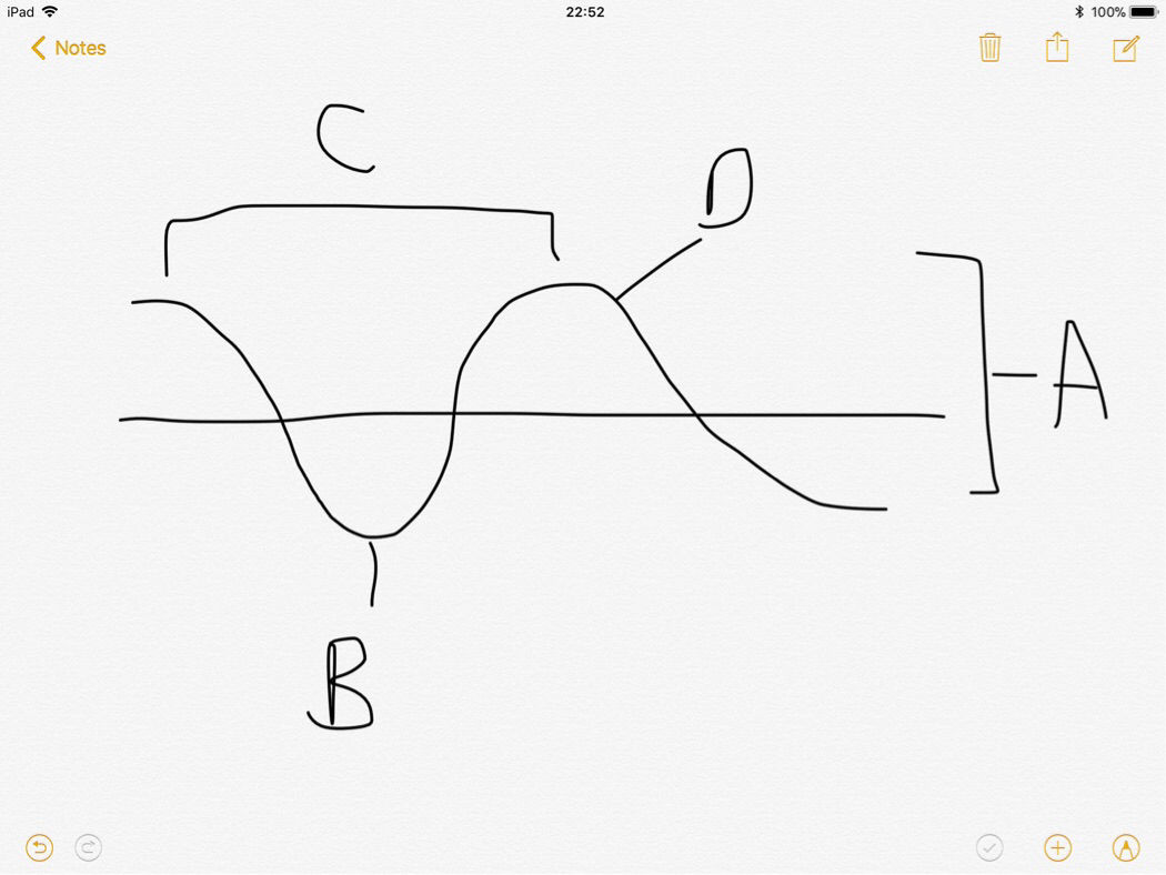
- 4What are A, B, C & DA waveheight
B trough
C wavelength (from crest to crest)
D crest - 5Constructive waves Swash is...Strong
- 6Constructive waves Backwash is...Weak
- 7Constructive waves Wave frequency is...Low
- 8Constructive waves As wave approaches beach...It loses energy
- 9Constructive waves Beach is...Gently sloping/built up
- 10Constructive waves Shape of wave...Wavelength is long, height is low
- 11Constructive waves Created in...Calm conditions
- 12Constructive waves Overtime, beach is...Wide and flat
- 13Destructive waves Swash is...Weaker
- 14Destructive waves Backwash is...Stronger(takes material from beach away with it)
- 15Destructive waves Wave frequency is...High
- 16Destructive waves As wave approaches beach...It breaks on beach with force and scours the beach
- 17Destructive waves Beach is...Eroded
- 18Destructive waves Shape of wave...Short and high shape
- 19Destructive waves Created in...Stormy conditions
- 20Destructive waves Overtime, beach is...narrow/steep with eroding headlands
- 21What is weatheringThe breaking down of rock in situ
- 22What are the 3 types of chemical weatheringCarbonation
Oxidation
Hydrolysis - 23What is carbonationCarbonic acid in rainwater comes into contact with limestone and reacts with calcium carbonate in thr rock to form calcium bicarbonate. This forming holes in the rock.
- 24What is oxidationOxygen and water break down rock, in iron rich rocks a rusty coloured surface
- 25What is hydrolysisAcidic rainwater causes rock to rot, producing clay and solvable salts
- 26What are the 2 types of mechanical weatheringFreeze-thaw
Salt-weathering - 27What is freeze-thawWater fills on cracks in rocks then freezes overnight, expanding and putting pressure on rock. Water thaw a and contracts. This repeats until rock breaks
- 28What is salt weatheringSalty water hits cliff face and gets into cracks. Water may evaporate, but the salt will crystallise and expand, putting pressure on the rock. Repeats until rock breaks
- 29What are the 3 mass movementsRock fall
Sliding
Slumping - 30What is rockfallWhere bare, well-jointed rocks are prone to freeze-thaw. This results in rock on vertical cliff faces loosing contact with the cliff so fall to bottom, where the y collect as a “scree-slope”
- 31What is slidingWhere rain infiltrates the soil and percolates into permeable rock. When this rock is saturated it slips along straight slip plain, maintaining contact all the way. It only occurs on steep cliffs with straight slip planes
- 32What is slumpingWhere water percolates from soil to permeable rock,which becomes saturated, putting weight on thin impermeable layer beneath, creating cracks. The permeable rock slides along this surface and collects at bottom as a hummocky toe.
- 33Are these concordant or discordantA. Concordant
B. Concordant
C. Discordant
D. Concordant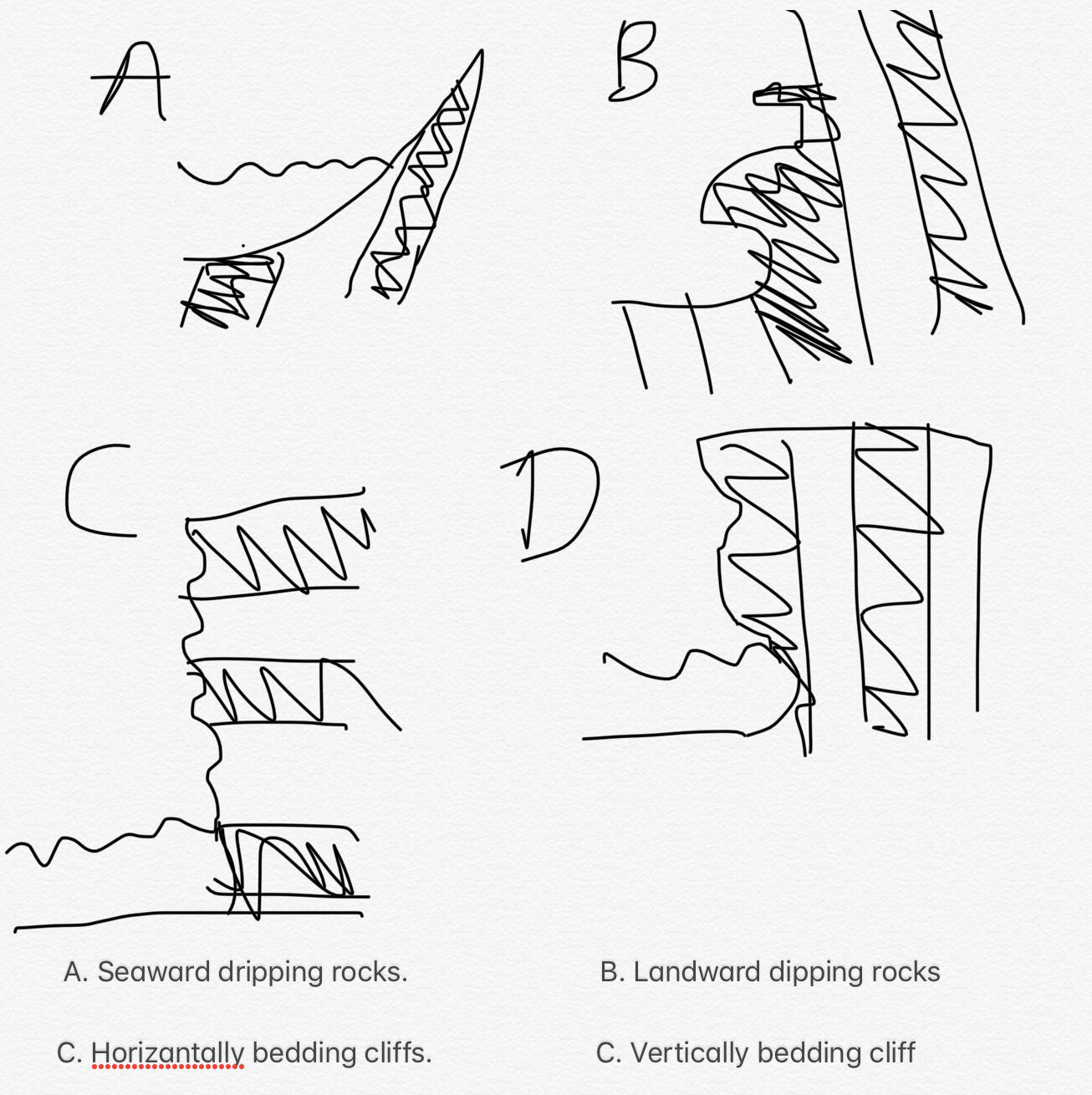
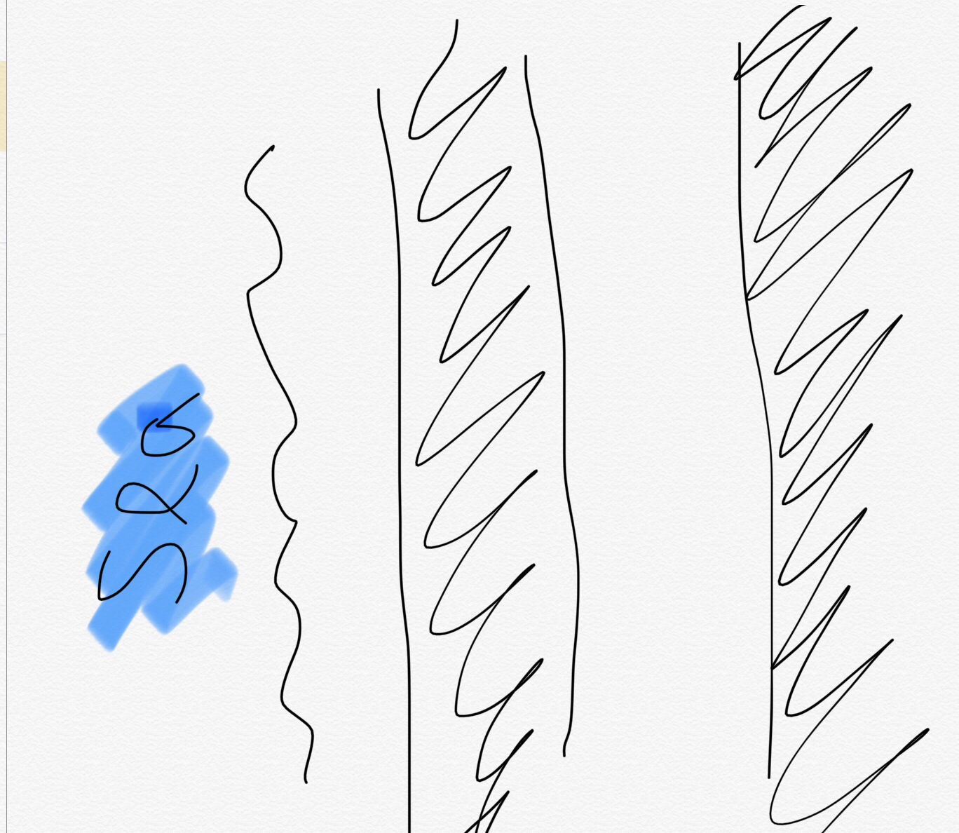
- 34What is concordantWhere there is the same rock all the way along the coast
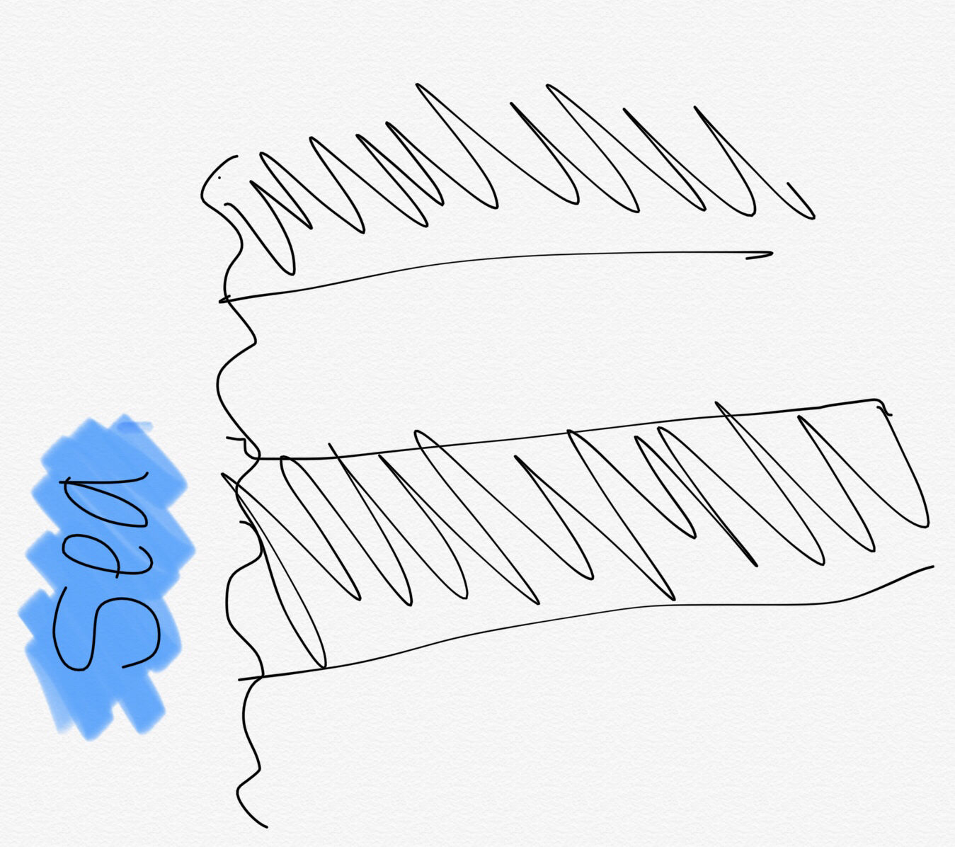
- 35What is discordantWhere there are different rocks alternating along the coast
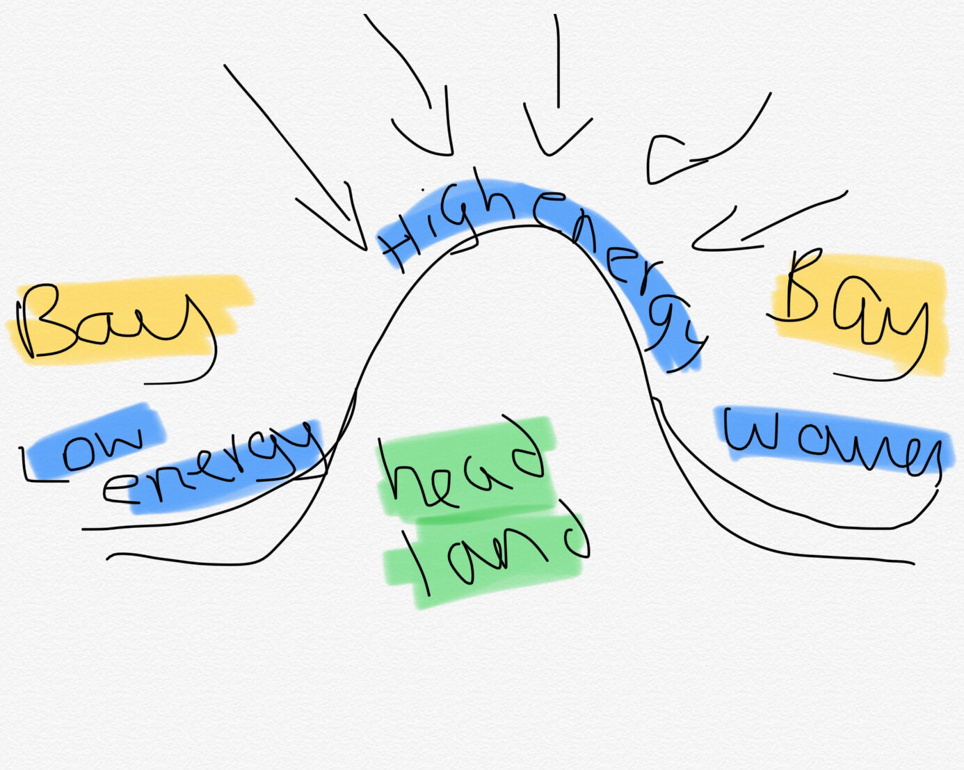
- 36What is wave refractionWhere the waves approaches the coast in a straight line. As it reaches the headland first it slows and builds in height, whereas the rest of the wave front carries on onto the bays and therefore bends to take on shape of thr coastline. This directs all waves energy towards headland
- 37Dorset coastline What rock is A, B, C,DA. Clay and sands(soft)
B. Chalk(hard)
C. Clay and sands(soft)
D. Limestone(hard) - 38Explain how a stump is formedFirst a joint fault/bedding plane causes a crack in the rock, which is then widened by highly concentrated wave energy or high tide and hydraulic action, forming a notch. This process repeats until it is a cave. Next, abrasion, attrition and solution widen the cave into a sea arch. The arch is widened until it can't support its own weight, so it falls through, forming a stack. The bottom of the stack is eroded until it falls over, leaving a stump
- 39How are wave-cut notches formedoriginal cliff slopes toward sea. Freeze that weathering weakens rock. Marine erosion is concentrated between high and low watermark. Hydraulic action and abrasion erode base creating a wave-cut notch
- 40How are wave-cut platforms formedas cliff retreats, former base of old cliff is left as a wave-cut platform. It will be continuously smoothed by shingle grinding over it in places, elsewhere it may become encrusted with barnacles/covered algae. Joints will be enlarged by hydraulic action
- 41how are cliffs formedcontinued erosion causes rocks to break away and collect at base of cliff. Destructive waves remove this material. The section of cliff above notch is un supported and eventually notch gets enlarged to the point that it can't hold its own weight. It falls and the resulting steep drop is called a cliff
- 42how are beaches formedmaterial eroded by rivers,from cliffs, or picked up from the sea is transported by longshore drift. Waves are constructive and have limited energy so material is deposited in sheltered areas e.g., bays. Beaches can grow with constructive waves and shrink with destructive waves.
- 43how are spits formedlongshore drift transports material in a zig-zag past the bend in coastline(e.g. headland/river mouth). Deposition occurs (when there's constructive waves at the bend and material builds up away from coast into sea until a long ridge of sand/shingle is created. If there's a wind direction change , the spit can develop a recurved (hooked) end. The area behind spit is protected from waves, so lots of deposition occurs, creating a salt marsh/mud flat over time. If this area becomes dry, sand dunes can develop
- 44Sand Dunes name 3 characteristicsgentle slope on windward side, crests, unstable, steep slip slope on sheltered lee ward slope
- 45Sand Dunes describe transportation of sand along dunesand is blown up windward slope until critical value point where it slips down leeward slope
- 46Sand Dunes For a sand dune to form, what is neededa large, flat, dry beach, lots of sediment, large tidal range, onshore wind (to move sand), an obstacle e.g. driftwood (to trap sand)
- 47Sand Dunes how is sand transportedsuspension(1%) - sand picked ip and carried by wind
saltation(95%) - grains of sand bounce along in wind
creep(41%) - sand grains collide with each other and push each other along - 48Hard engineering Explain how a sea wall (recurved) worksrecurved face rotates wave backwards so that some energy is reflected back to sea. This impedes the next wave, reducing its energy and erosive power . Essentially, it is a concrete barrier which absorbs the wave's energy
- 49hard engineering-sea walls what are pros and conspros: don't disadvantage other areas, make people feel safe, last a long time, stops erosion
cons: restricts access to beach, expensive (£5000/m), require constant maintenance, look ugly, unnatural - 50Case study : Swanage to Poole Harbour Describe thee geology/geological structure?Along the South coast it is concordant hard limestone, and on the indented coast it is disconcordant with layers of hard and soft rock where soft rocks are creating bays and hard rocks creating headlands.
- 51Case study : Swanage to Poole Harbour Describe where it is locally/ Nationally ?Southwest of Bournemouth, West of Isle of Wight. Swanage is the large town on the Isle of Purbeck
A peninsula in Central South England, South of Dorset. - 52Case study : Swanage to Poole Harbour Why has sediment been deposited at Swanage BayWave refraction at the headlands led to low energy environment in the bay where deposition can occur (with constructive waves)
- 53Case study : Swanage to Poole Harbour Why does beach not form along the coastline from Ballard point towards The Foreland?It is a headland, so it is a high energy environment with destructive waves and wave refraction, so erosion is happening, not deposition, so a beach can form.
- 54Case study : Swanage to Poole Harbour What is the stack called at the end of the Foreland?Old Harry (054825 grid reference)
- 55Case study : Swanage to Poole Harbour What are the names of the 3 headlands South of the Foreland?Ballard Point, Peverill Point, Duriston Head
- 56Hard engineering:-Explain how groynes work?They are wooden/ stone structures built into the foreshore that create a larger beach by trapping sediment transported by longshore drift . They're built at right angles to the beach and spaced at regular intervals
- 57Hard engineering:-Explain how groynes work: Pros?Pros- larger beach, more space for activities and tourists attracted. Relatively cheap (£5000 each), they act as a windbreak.
- 58Hard engineering:-Explain how groynes work: Cons?Cons- Makes it harder to walk along beach, safety concern- deep water on one side, shallow water on other. Surfers may collide into them. Only last 40 years (if well maintained). They have to be replaced. Expensive , unattractive and restricting movement of longshore drift which means beaches downdraft is starved of sediment.
- 59Hard engineering:- Explain what rock armour is?Tonnes of boulders and barriers that trap wave energy
- 60Hard engineering:- Explain what rock armour is? Prospros: Can't be moved by destructive waves, relatively cheap- £1000-£3000/ meter, quick to build, natural resources, last 120 years, look nicer than other hard engineering . Blends in more.
- 61Hard engineering:- Explain what rock armour is? Conscons: Makes beach less accessible, seaweed can cause slip hazards, rocks could be unstable, sometimes local rocks aren't used. Litter can be trapped in between rock.
- 62Hard engineering:- Explain how a Gabion works?They are rocks held in containers that reduce the rate of erosion by dissipating the waves energy when water enters the gabion. Last 20-25 years (cheapest hard engineering.)
- 63Hard engineering:- Explain how a Gabion works? Prospros: Cheap £110/ meter. Easily constructed, covered in vegetation,, prevents landslides (placed in front of cliff)
- 64Hard engineering:- Explain how a Gabion works? Conscons: Can be dangerous for people and animals ( e.g. birds feet trapped), need regular maintenance, which is more expensive when gabion becomes covered in vegetation.
- 65Soft engineering:- Explain how Beach nourishment works?Replacement of lost sediment by beach recharge (taken from bay and placed on beach) or beach recycling ( taken from down and drift area which is building up sand and returning it updrift. Makes a nourished beach which means fewer waves reach back of beach so more wave energy is absorbed and dissipated by beach.
- 66Soft engineering:- Explain how Beach nourishment works? ProsPros- Wider beach equals more space for beach users, attracts tourists, protects beach from flooding, reduces sea wall maintenance costs, cheap, often uses volunteers, blends in, creates new habitats.
- 67Soft engineering:- Explain how Beach nourishment works? ConsCons. donor beach restricted for weeks, high costs ( £300,000 to hire dredger) has to be checked twice a year.
- 68Soft engineering:- Explain what sand dune regeneration is?The artificial regeneration of sand dunes which act as a physical barrier between sea and land.
- 69Soft engineering:- Explain what sand dune regeneration is? ProsPros: Popular area for picnics/ walking areas, protect land behind them, helps maintain habitats of rare wildlife.
- 70Soft engineering:- Explain what sand dune regeneration is? Conscons: No guarantee that they'll work, they are fenced off which may deter public and tourists, expensive systems have been put in place to protect planted areas.
- 71Soft engineering:- Explain how beach reprofiling works?The artificial reshaping of a beach using exiting beach material. In winter the beach is lowered by destructive waves. after winter storms, bull dozers move shingle back up the beach.
- 72Soft engineering:- Explain how beach reprofiling works? ProsPros: Protects area behind beach, cheap compared to hard engineering. looks natural.
- 73Soft engineering:- Explain how beach reprofiling works? ConsCons: During reprofiling beach has restricted access, major reproofing is expensive, steep high crested beach can be unattractive to tourists.
- 74Soft engineering:- What is coastal realignment?Creating a new, engineered position of the coastline (This involves moving the coasting boundary inland). Its done by making a breach in the existing sea defences so the sea can inundate the land and create intertidal habitats.
- 75Soft engineering:- What is coastal realignment? ProsPros: Cheaper in the long term, managed retreat, designed to conserve/ enhance natural environment. new species of birds are often recorded on new mud flats.
- 76Soft engineering:- What is coastal realignment? ConsCons: relocation of people causes distress and disruption, short term costs are high (relocation costs) habitats of coastal birds would initially decline.
Informationen
- Beschreibung
- Year 10 Geography (Issy) Karteikarten am coasts, erstellt von issy boydell am 22/02/2018.
- Erstellt von
- issy boydell
- Aufrufe
- 22
- Bewertung