
Karteikarten
Forensic Geoscience
Karten in diesem Stapel (53)
- 1what is Forensic GeoscienceForensic Geoscience is a comparatively recent discipline concerned with the application of geological and environmental science methods to investigations, which may subsequently be heard by a criminal or civil court. It is a wide-ranging, rapidly expanding and interdisciplinary subject area that is becoming increasingly accepted and used in mainstream Forensic Science. Forensic Geoscience includes methods and techniques derived from fields such as geology, geophysics, geochemistry, sedimentology, geoarchaeology and geobiology.
- 2Forensic geoscience can be divided up intomacro and micro-scale applications.
- 3Macro scale applicationsforensic geophysics, geomorphology and remote sensing. These techniques would be used for mapping crime scenes on the larger scale, finding buried bodies etc.
- 4Micro-scale level forensic geoscience concentrates ontrace evidence, material that can be used in linking suspects to scenes of crime. Examples here would be a range of microscopy and geochemical techniques that can be used to match soil, building products, rock debris, biological trace fossils etc from suspect's shoes or clothing, cars or house to the crime scene.
- 5Difficulties between the two sides of the disciplinethe distinctions between these two sides of the discipline can be blurred. For example footwear and tyre-tread mark analysis are examples of features that can be traced within the landscape at the macro-scale but are more often than not analysed at the micro-scale. Similarly a stratigraphic section could be examined at one location at the microscale but have implications at the macro-scale.
- 6history of forensic geosciencefirst appeared in fiction before they were tested in an actual court case. For instance Sir Arthur Conan Doyle's first novel featuring Sherlock Holmes, A Study in Scarlet which appeared in book form in 1888 and included a short section on shoe print analysis. There were other stories with a forensic geology basis including The Five Orange Pips in 1891 and Through the Magic Door in 1907. Conan Doyle had been trained in geology, mineralogy and soils whilst reading natural sciences at Cambridge University. He commonly uses classic trace evidence linking soil on suspects' clothes to crime scenes. At the time these techniques were all untested by court of law or peer-review publication.
- 7history of forensic geoscience who is The probable founder of scientific forensic geoscience criminal investigationHans Gross (1847-1915). He published a Handbook for examining magistrates in 1893 which included sections on the more usual forensic techniques as well as forensic geology.
- 8who is credited as the first forensic scientist to use geological evidence to solve a crime.Georg Popp (1867-1928)
In October 1904 whilst employed as a forensic laboratory scientist he was asked to help solve the murder of a seamstress Eva Disch, who had been strangled in a field by her own scarf. By the body there was a dirty handkerchief apparently left by the murderer containing bits of coal, particles of snuff and a variety of minerals, particularly the mineral hornblende. - 9who is The main suspect in the casea man named Karl Laubach, who was known to use snuff and who worked part-time in a coal-burning gasworks and also part-time at a local gravel pit.
- 10Popp examined the body of Eva Disch and extractedbits of coal and grains of several minerals, including hornblende from under her fingernails. He was also able to obtain the clothing worn by the suspect on the day of the murder; he made a close examination of the legs of Mr. Laubach's trousers and removed a variety of soil samples from them.
- 11When he performed a microscopic examination of the soil samples, he discovereda lower layer consistent in makeup to a soil sample previously obtained from the murder scene. When he examined an upper layer of soil from the trousers, he found a mineral blend consistent with soil samples removed from the path between the murder site and the suspect's home.
- 12Popp's forensic scientific conclusion was that the suspect's clothing picked up the lowerlayer of soil at the scene of the murder; this layer was then covered by mineral-laden mud splashed upon the trousers during the suspect's return home. When interrogated and presented with the analysis of evidence found in his handkerchief and clothing, Karl Laubach confessed to the murder. The publicity surrounding the solution of this case established Georg Popp as a forensic geological expert.
- 13The use of geologic information in forensic settings was established internationally when?in 1908, when Georg Popp was again called upon to assist in the solving of the Margarithe Filbert murder case. In this case, he focused his examination on the shoes of the principal suspect; he examined the layers of dirt encrusted between the sole and the front of the heel. The shoes were known to have been cleaned by the suspect's wife on the night before the murder occurred, so it was Popp's hypothesis that the soil had been sequentially accumulated on the day of the murder with the layer closest to the shoe leather deposited first, and so on.
- 14By carefully removing each individual layer of soil and examining it microscopically, Popp was able toretrace the steps, literally, taken by the suspect on the day of the murder. He was able to match the soil from the shoes to the soil surrounding the suspect's home, to the scene of the crime, and to the location where the shoes had been hidden by the suspect. His solution of this case firmly established Georg Popp at the forefront of forensic geology. Georg Popp's microscopic examination of minerals and soil samples set a precedent for the continuing use of soil samples as an integral part of forensic investigation.
- 15He used a combination of mineralogy(two types of quartz), rock (white porphyry) soil (red clay) and other materials including green goose droppings in his evidence. This use of many strands of evidence approach is still one of the most powerful available today.
- 16Edmond Locard (1877-1966) developed one of the more fundamental theories of forensic science known as Locard’s Exchange Principle which states thatwhenever two objects come into contact, there is always a transfer of material. However the detection methods may not be sensitive enough to demonstrate it, or the decay rate may be so rapid that all evidence of transfer has disappeared after a given time.
- 17Throughout the first half of the 20th century governments and universities in north-west Europe and the USA began developing specialised laboratories capable of geological forensic investigation. The first university course in forensic science was in1909 in Lausanne Switzerland, whilst FBI labs were established from 1924. The Metropolitan Police set up a forensic science laboratory in Hendon, north London in 1935 and the Central Research Establishment was set up at a nuclear facility at Aldermaston in 1966.
- 18Walter McCrone (1916-2002) developed the use ofchemical microscopy in order to test historical theories. His most famous analysis was that of the Turin Shroud which was based on optical microscopy but also used radiocarbon dating and palynology. He suggested that they red stains supposedly of blood were in fact pigment of red ochre and vermilion tempera paint In 1988 independent AMS radiocarbon dating suggested that the linen dated to between about 1216-1390.
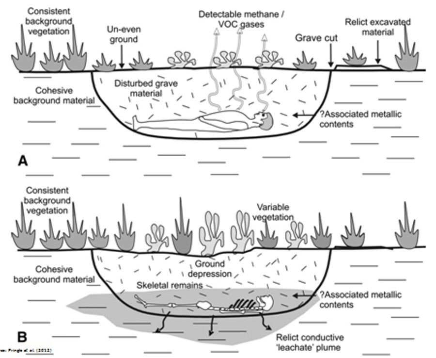
- 19The Vinland Map is claimed to be a 15th century map of the world whichpurportedly shows Norse exploration of America well before Columbus. Dating of the parchment in 1995 gave an age of between 1411 and 1468, however Walter McCrone found the ink contained synthetic anatase which was not incorporated in England until the 1920s.
- 20The macro scale: forensic geophysics, geomorphology and remote sensing 3.1 Identification of search areaThe first step is to identify the limits of the search area or areas. This could be a desktop study combined with a reconnaissance site visit, followed by the implementation of a satisfactory search strategy.
- 21The macro scale: forensic geophysics, geomorphology and remote sensing 3.1.1 Remote sensingThis could include aerial photography, topographic mapping, satellite imagery and GPS applications. Aerial photographs can be used to identify unusual features, especially when the photographs are taken when the sun is at a low angle. Crop marks may also be used. Historical photographs are also a useful resource because they can identify change. Access points are prime search areas because heavy objects are rarely carried more than 150 m before being buried.
UV photography is increasingly being used in forensic investigations to map vegetation on the assumption that any vegetation growing over recently buried material will be younger than the surrounding plants. LIDAR (Light Detection and Ranging) airborne systems can be used to collect 3-D topographic data at high resolution to create a digital elevation model. Rotary and fixed wing unmanned air vehicles (UAVs) are becoming mainstream in UK police service operations enabling real-time remote sensing to be conducted a research area in a covert manner. - 22The macro scale: forensic geophysics, geomorphology and remote sensing 3.1.1 Remote sensing continuedThermal imaging can be used to clandestine burials and illegal waste deposition. Clandestine graves are thought to be most easily detected with thermal imaging techniques during the first few weeks of burial though this will be influenced by geology, groundwater level and soil type.
- 23The macro scale: forensic geophysics, geomorphology and remote sensing 3.1.2 GeomorphologyGeomorphological mapping can be used in forensic context through the use of a combination of topographic landform and hydrological maps to subdivide and prioritise potential search subareas. In Northern Ireland technique is proven useful for locating graves of murder victims. In one case in Northern Ireland the search area was divided into 10 different subareas based on a landform mapping approach including visibility from road and paths.
- 24The macro scale: forensic geophysics, geomorphology and remote sensing 3.1.3 Geology and soil mappingKnowledge of geology and soil types can often be very important in forensic investigations. Geology can determine where objects can and cannot be buried and should be considered prior to search. Often geological and soil trace evidence can help to identify potential search areas and also to exclude other areas. In the UK over the last 10 years large scale spatial digital databases and maps of solid and superficial geology, soil properties and geochemistry have been constructed and they've been used for a range of applications.
- 25The macro scale: forensic geophysics, geomorphology and remote sensing 3.1.4 Metal detectorsMetal detectors either individually or as part of search team can be used during initial search investigations or as part of program when looking for shallow buried metallic material in appropriate environments.
- 26The macro scale: forensic geophysics, geomorphology and remote sensing 3.1.5 Search dogsSometimes specially trained search dogs can also be used again during initial searches or as part of a phased programme and they can be used to identify a variety of different buried objects including IEDs, drugs, human remains. The success rate is greater for surface human remains (55-95%) compared to buried human remains (20-40%). Venting by probing the surface can release gases which dogs can then sent and increase their success rates\\\
- 27The macro scale: forensic geophysics, geomorphology and remote sensing 3.1.6 Reconnaissance, CGM, Diggability and RAGA reconnaissance visit to the search area should be undertaken to see if there are any features or obstacles that could influence the choice of areas to be searched, or techniques to be used.
Conceptual geological models (CGMs) provide information on the expected target size, age, geometry, depth and surrounding ground and vegetation conditions.
Linked to the CGM is a Digg ability survey which is an assessment of how easy it is to excavate and reinstate the superficial deposits. Finally a simple RAG map (Red-Amber-Green) can be constructed showing areas to be investigated in order of priority. - 28The macro scale: forensic geophysics, geomorphology and remote sensing 3.1.6 Reconnaissance, CGM, Diggability and RAG
- 29The macro scale: forensic geophysics, geomorphology and remote sensing 3.2 Site investigationsOnce the search area has been identified the investigators will normally then decide upon the optimal combination of search techniques.
- 30The macro scale: forensic geophysics, geomorphology and remote sensing 3.2.1 SeismologyThis is used on a very large scale in the investigation of international incidents involving explosions and impacts where the energy released can be detected by seismic networks. Examples of forensic seismology include the investigations of the Kursk submarine disaster the Lockerbie aeroplane crash, the Oklahoma City bombing and the US Nairobi embassy bombing.
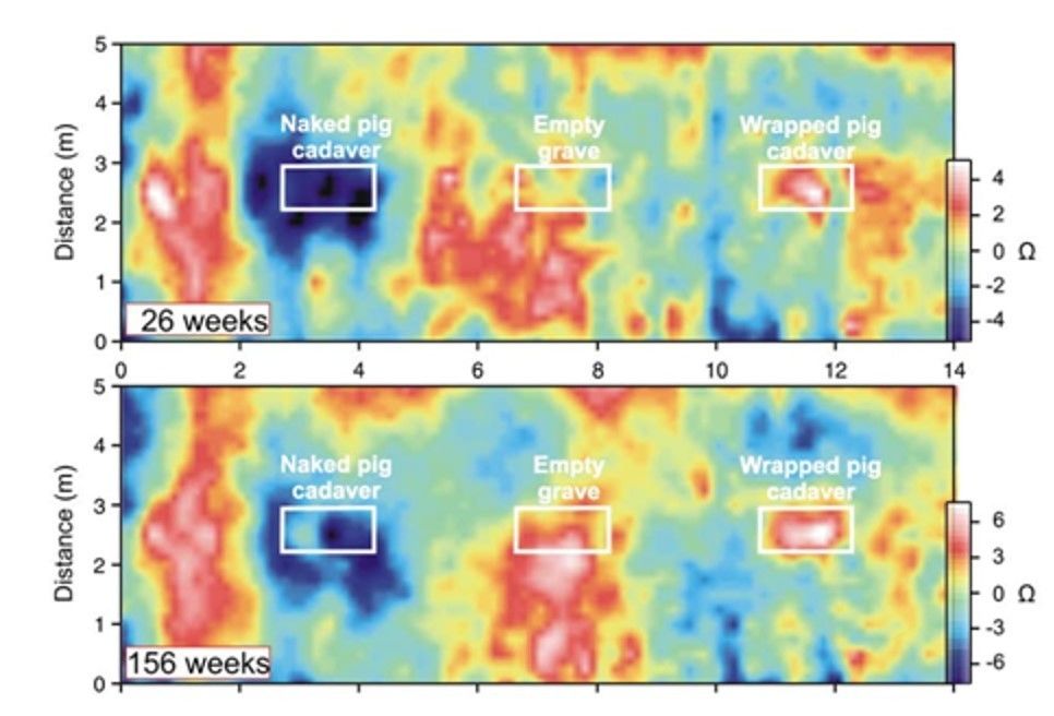
- 31The macro scale: forensic geophysics, geomorphology and remote sensing 3.2.2. Resistivity and electrical tomography.Near surface materials are often very variable and comprise soil, rock and made ground. They differ in organic and water content, density, structure and texture, cation exchange capacity all of which affect electrical resistivity. Electrical resistivity tomography is geophysical technique for imaging subsurface structures from electrical measurements made at the surface or by electrodes inserted in two boreholes. It uses a direct current to measure electrical resistivity in a 3-D space.
- 32The macro scale: forensic geophysics, geomorphology and remote sensing 3.2.2. Resistivity and electrical tomography.
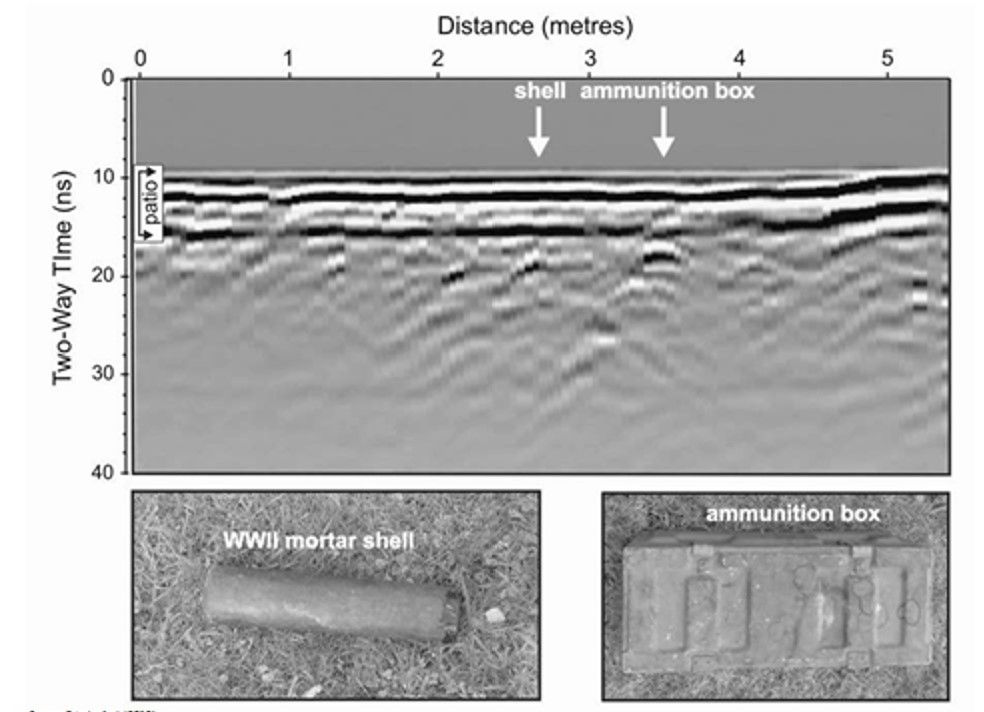
- 33The macro scale: forensic geophysics, geomorphology and remote sensing 3.2.3 Ground penetrating radarThis is a commonly used geophysical technique for near surface analysis often used for the detection of unmarked grave locations, clandestine graves and various other buried materials. It uses electromagnetic radiation in the microwave band and detects the reflected signals from underground structures. It is of high resolution and data can be obtained relatively quickly. One of the most commonly used techniques for near-surface target detection and is also widely used in the geotechnical industry to locate buried utilities. The diagram below shows GPR signals for a World War II mortar shell and ammunition box buried under a patio. However it is not optimal in certain search environments, for example woods and waterlogged, salty, clay-rich and mixed soil types.
- 34The macro scale: forensic geophysics, geomorphology and remote sensing 3.2.3 Ground penetrating radar
- 35The macro scale: forensic geophysics, geomorphology and remote sensing 3.2.4 Magnetic susceptibilityVery sensitive magnetometers have had varied success in forensic investigations. Ancient archaeological graves sometime show high magnetic susceptibility probably due to the long-term mineral changes caused by bacterial action. Magnetic results over simulated recent clandestine burials in a variety of deposition environments have proved to be not that successful. Non-metallic object will not show up.
- 36The macro scale: forensic geophysics, geomorphology and remote sensing 3.3 Post-search investigationsOnce the fieldwork has been completed, the data processed and interpreted then a report is usually written prioritising a list of areas for intrusive investigation. Then an archaeological forensic investigation begins using exploratory trenches and excavations.
- 37The macro scale: forensic geophysics, geomorphology and remote sensing 4. Micro-scale applicationsAt the micro-scale forensic geoscience applications usually involve trace evidence analysis which can be applied to things like air, paint, glass, fibres, metals and more recently soils, minerals, geochemistry, pollen and other microfossils.
- 38The macro scale: forensic geophysics, geomorphology and remote sensing 4.1 Rocks, soils and sedimentsIt is becoming more recognised that potentially much useful information is locked up an even small amounts of soil and this is due to come from its prevalence at crime scenes and its transferability between the scene and the suspect. Soils and sediments are composed of naturally occurring rocks, minerals, plants and animals but also anthropogenic component such as glass, paint fragments, metallic particles etc. Soil recovered from clothing, a vehicle were a crime scene has a large, almost limitless number of characteristics which make it unique and which relate to the climate, geology and land use of the site from which the soil was derived.
Rocks can be divided up into igneous, sedimentary and metamorphic rocks each with different general characteristics - 39The macro scale: forensic geophysics, geomorphology and remote sensing 4.1 Rocks, soils and sediments continuedIgneous rocks: the parent material for igneous rocks is called magma, and is formed by a process called partial melting. Partial melting occurs at various levels within the Earth’s crust and upper mantle to depths of 250 kilometres (about 150 miles).
Once formed, a magma body rises toward the surface because it is less dense than the surrounding rocks. Occasionally molten rock reaches the Earth’s surface as lava. Igneous rocks that form when molten rock solidifies at the surface are classified as extrusive, or volcanic. Magma that crystallizes at depth is termed intrusive, or plutonic. Intrusive igneous rocks outcrop at the surface when the crust is uplifted and the overlying rocks eroded
Igneous rocks are or grouped on their texture and mineral composition. - 40The macro scale: forensic geophysics, geomorphology and remote sensing 4.1 Rocks, soils and sediments continued
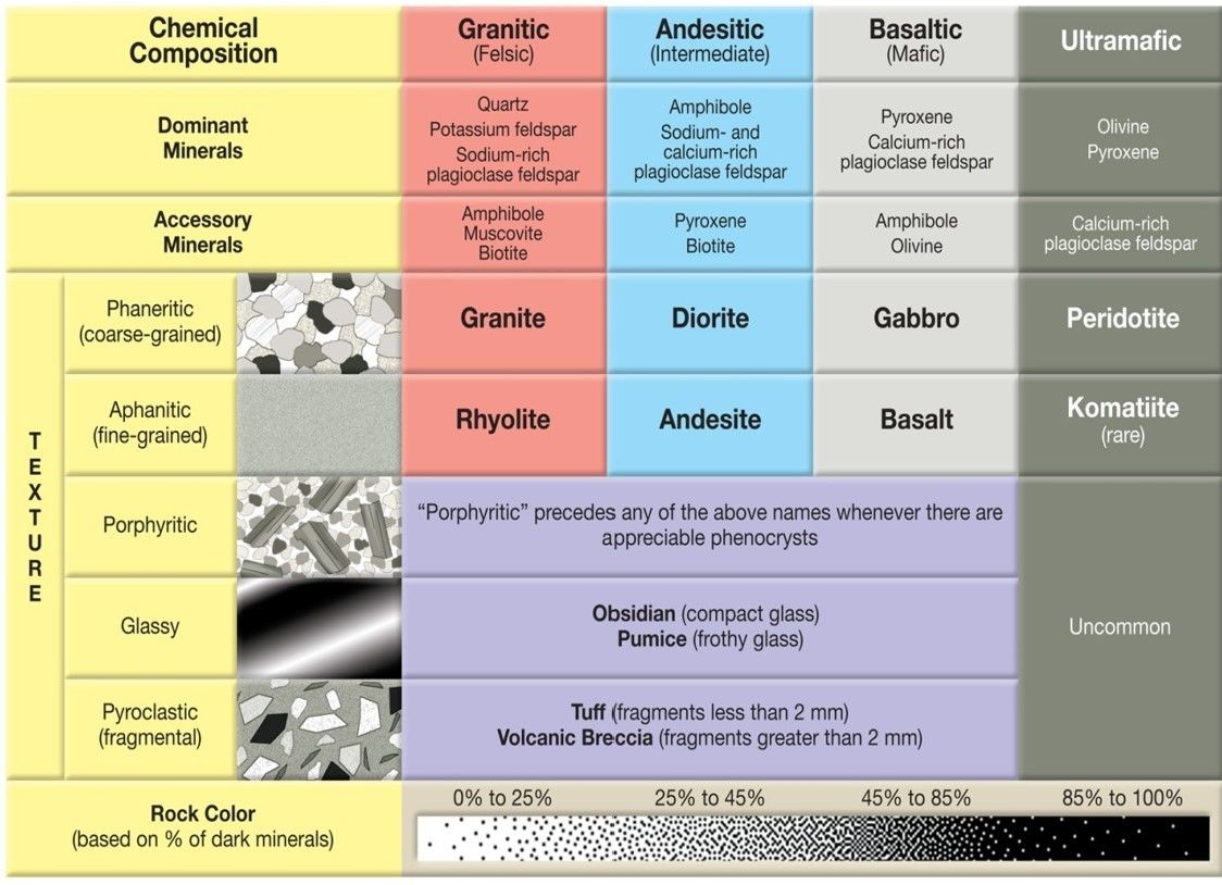
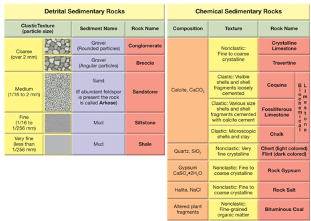
- 41The macro scale: forensic geophysics, geomorphology and remote sensing 4.1 Rocks, soils and sediments continuedSedimentary rocks can be divided into two major groups: detrital and chemical. Further subdivision of detrital rocks is possible through particle size, whereas the primary basis for distinguishing among different rocks in the chemical group is their mineral composition
- 42The macro scale: forensic geophysics, geomorphology and remote sensing 4.1 Rocks, soils and sediments continued
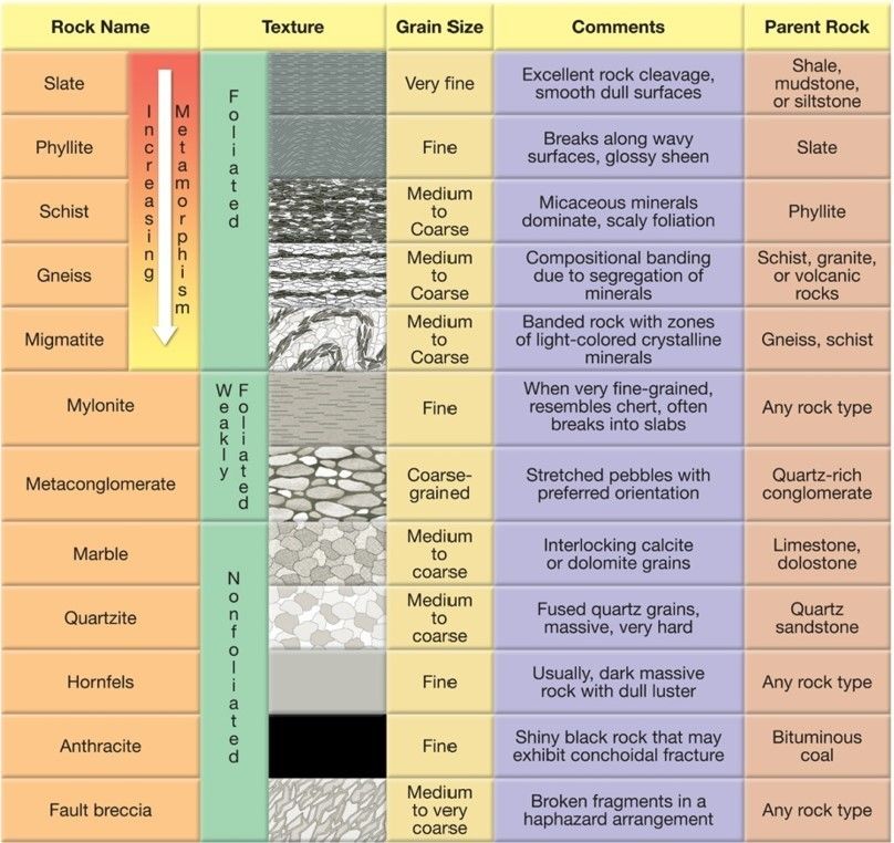
- 43The macro scale: forensic geophysics, geomorphology and remote sensing 4.1 Rocks, soils and sediments continuedMetamorphism is the transformation of one rock type into another. Metamorphic rocks are produced from pre-existing igneous, sedimentary, or even from other metamorphic rocks. Thus, every metamorphic rock has a parent rock - the rock from which it was formed. Metamorphism, which means to “change form,” is a process that leads to changes in the mineralogy, texture, and often the chemical composition of rocks. Metamorphism takes place where pre-existing rock is subjected to a physical or chemical environment that is significantly different from that in which it initially formed. These include changes in temperature, pressure (stress), and the introduction of chemically active fluids. In response to these new conditions, the rock gradually changes until a state of equilibrium with the new environment is reached.
- 44The macro scale: forensic geophysics, geomorphology and remote sensing 4.1 Rocks, soils and sediments continued
- 45The macro scale: forensic geophysics, geomorphology and remote sensing 4.1 Rocks, soils and sediments continuedSoils are incredibly complex entities and often take many hundreds or thousands of years to form. Many show evidence of horizonation with translocation of material either up or down the profile.
Sediments can be characterised by their particle size and shape. Below is a classification of particle shape. - 46The macro scale: forensic geophysics, geomorphology and remote sensing 4.1 Rocks, soils and sediments particle shape
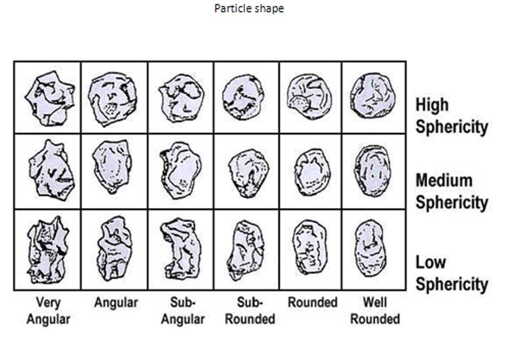
- 47Each environment will produceits own characteristic sediments. For example a beach will usually provide well rounded and well sorted gravel with a high scarcity, or a well sorted sand, or both.
A lake or deep sea environment will usually provide very fine sediments of silt and clay.
A glacier will lay down a characteristically unsorted type of sediment called till. This comprises angular unsorted particles of most size classes. - 48a table showing particle size classes ranging down in size from boulders to gravel to sand to silt and clay.
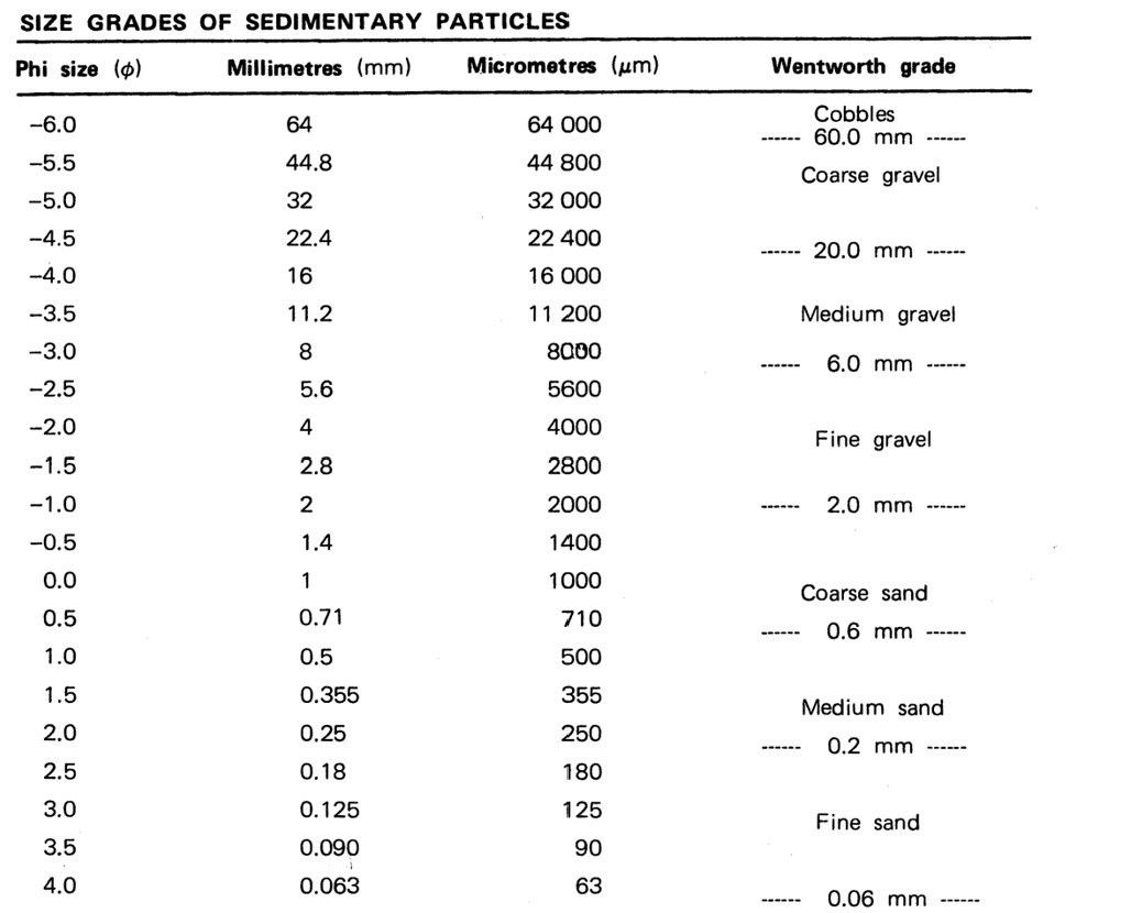
- 49a table showing particle size classes ranging down in size from boulders to gravel to sand to silt and clay.
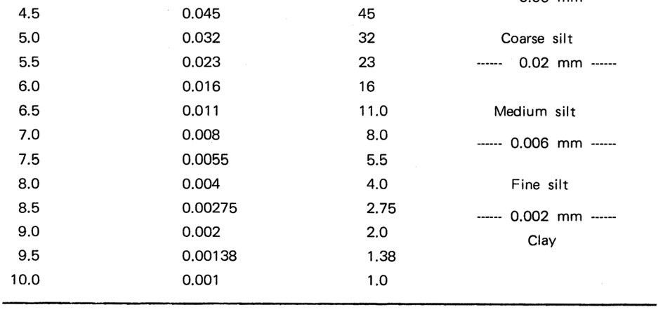
- 50The micro scale: forensic geophysics, geomorphology and remote sensing 4.2 Chemical applications Mineralogy:most rocks are made of minerals - these are combinations of inorganic compounds – over 2000 minerals are present on the Earth but almost all the common ones are related to 10 major mineral groups.
Minerals are made of elements. Only eight elements are abundant these are: oxygen, silicon, aluminium, iron, calcium, sodium, potassium and magnesium and comprise about 99% of the total weight of the Earth’s rocks.
Minerals such as quartz are highly resistant to weathering and can survive several cycles of erosion and deposition. At the other end of the scale, others such as olivine are more easily destroyed during weathering.
Minerals can be detected by taking a thin section of rock and noting mineral colour changes as they are rotated in polarised light.
Geochemistry: Minerals are made up of elements which can be detected using Inductively Coupled Plasma Mass Spectrometry ICPMS. Geochemistry can therefore build up a detailed picture or fingerprint of a sediment’s chemical properties that then can be used in trace material analysis. - 51The micro scale: forensic geophysics, geomorphology and remote sensing 4.2 Biological Trace Evidence Pollen:Pollen: pollen is produced by flowering plants, it is the male gamete and is produced in
huge quantities. Pollen is microscopic with most taxa being between 20 and 100 µ (microns).
Different species of plant have different methods of pollination, the majority release
pollen directly into the air, some are pollinated by insects, others released pollen
directly into water.
Pollen can be destroyed by oxidation but in waterlogged environments can be
preserved almost indefinitely.
Its use in forensic science is largely as trace evidence but care must be taken with
contamination.
In general pollen from tall tree species that are high producers and release
pollen into the air will travel further than pollen from plants with a low growth habit that are insect pollinated. - 52The micro scale: forensic geophysics, geomorphology and remote sensing 4.2 Biological Trace Evidence Diatoms:Diatoms: diatoms are unicellular algae with a silica shell. The cell contains chloroplasts and
therefore diatoms are photosynthetic, taking in carbon dioxide and giving out oxygen.
They are extremely abundant and reproduce both asexually and sexually. They are common wherever there is sufficient light, nutrients and moisture. There are estimated to be about
200,000 species of diatoms though only 20,000 have been named. Diatoms are largely microscopic ranging from 3 to 3000 µ, most being below 100 µ.
Consequently they are abundant in a very wide range of environments, from marine to freshwater, acidic to alkaline, low nutrient to high nutrient, low pollution to high pollution.
Different species also have different lifestyles, some are free-floating or planktonic, others are attached to surfaces and others live in the sediment of lakes, rivers and the ocean.
In forensic science diatoms can be used as trace material and provide information to inform on drowning cases.
Again care must be taken over contamination of samples.
Other microfossils that could be used include foraminife - 53—
Informationen
- Beschreibung
- Karteikarten am Forensic Geoscience, erstellt von megan trent am 19/01/2021.
- Erstellt von
- megan trent
- Aufrufe
- 0
- Bewertung