
Karteikarten
Geog 1002
Karten in diesem Stapel (198)
- 1What is geomorphology?The science of the Earth's surface features
- 2What are landforms?Individual features of the area
(glaciers/ rivers/ landslides etc.) - 3What are landscapes?A combination of all of the landforms adding to define an area
- 4What are the 4 areas of geomorphology?1. Fluvial
2. Aeolian
3. Glacial
4. Permafrosts - 5When can permafrost be classed permafrost?Areas frozen for two years or more
(Mainly in the Northern hemisphere) - 6What influences does geomorphology have on other spheres of work?1. Global changes
2. Geology - structural and petroleum
3. Environmental engineering
4. Archeology
5. Ecology
6. Planetary science
7. Environmental policy and management - 7Why is the study of geomorphology important?- To understand how landforms and landscapes have evolved and what controls them
- It is then important to be able to make what if scenarios to see what would happen if controls changed (for protection - especially when climate change are increasing differences and showing wider potential impacts for society) - 8What controls are there on landform evolution?1. Force equilibrium
The balances of forces and processes on the land
2. Force vs. resistance
The energy available to move objects vs. friction inputs
(forces that drive vs. forces that resist) - 9What are the 3 main scales to think about?1. Space
2. Time
3. Processes - 10What is meant by the mass balance concept?INPUTS - OUTPUTS = CHANGE IN STORAGE
- Mass balance shows how systems will evolve
- Can be applied to the 'mass' of any identifiable component of a system (water/ sediment/ climate/ finance/ demography) - 11What is meant by landform/ landscape sediment budgets?- Landforms are sediment stores
- The sediment budget is the inputs and outputs
- Spatial differences in sediment transfer = changes in storage = landform evolution - 12What is the importance of time and sediment budgets?- Landscapes we see today may not evolve at the temporal scales we observe them in
- The time and degree of magnitude events happen in is very important - 13What are exogenic processes?Processes on the surface
- 14What are endogenic processes?Processes within the earth
- 15What can be considered inputs of sediment?1. Weathering
2. Erosion
3. Uplift - 16What can be considered outputs?1. Rivers
2. Glaciers
3. Humans - 17What are the processes for change in the size of a glacier?Precipitation - albation = change in glacier size
- 18What are examples of mass wasting processes?1. Mudslides
2. Landslides - 19What are the sediment transfer processes/1. Atmospheric (heat and moisture)
2. Aeolian
3. Coastal (waves and currents)
4. Geological (vulcanism and tectonics)
5. Mass - wasting (gravity)
6. Biological (plants and microbes)
7. Periglacial (freezing + thawing)
8. Glacial (moving ice)
9. Fluvial (running water) - 20What are the implications of sediment transfers?ON GEOLOGY: Tectonics create topography, weathering converts this rock to sediment
ON GEOMORPHOLOGY: Sediment transfer processes redistribute sediment spatially across the landscape, modifying topography through erosion + deposition (this can then (with time) feedback to influence tectonics!) - 21What determines how landforms evolve?Combinations of competing process rates
- 22What are process rate modulated by/The properties of Earth surface materials (resistance), climate and inherited topography (tectonics/ slope gradients)
This implies there should be a predictable distribution of landscapes with a characteristic geomorphology that reflects the dominant processes active in that place/ time - 23What is meant by the mass balance concept?Input - Output = net change in storage
- 24Where is erosion rate greatest (in terms of sediment storage)?- Erosion (or deposition) is driven by spatial differences in sediment transfer across a slope
- Erosion is greatest where spatial differences in sediment flux are greatest - 25How does material move through hill slope sediment transfer?DIFFUSIVE PROCESSES - (slow, but all of the soils across the whole slope)
1. Creep
2. Solifluction - water (liquefaction)
MASS - WASTING - (fast, but localised)
1. Rolling
2. Sliding
3. Falling - 26What processes and factors control the (gradual) downslope movement of sediment?1. Rainsplash - sediment dispersed out then gravity moves it downslope
2. Bioperturbation - animals/ vegetation uplifting and distributing soil
3. Ground 'heaving' from
- Wetting/ drying cycles
- Freeze/ thaw cycles
- Thermal expansion/ contraction
Soil gets lifted and comes back down on an angle - 27What makes for the movements involving ground heaving?* Heave is considered to be 'normal' (90') to the slope
* It settles under the weight of gravity (centre of Earth, rather than the slope) - 28What are the 3 factors that drive hill slope?1. Angle of slope
2. Heave - how far up to come back down...
3. Frequency - often = greater rate, less often = slower rate - 29What is the rate equation for hill slope sediment transport?Rate (length/ time) = heave distance and heave frequency and slope
Q= f (h, Fh) x 0
Where Q = rate, Fh = frequency, h= heave and 0 = angle - 30What is the importance of the hill slope diffusion coefficient (Kc)?Describes the relationship between heave distance and heave frequency
Q = Kc x 0 - 31What is a slope defined as mathematically?Slope = change in elevation (z) over a given distance (x)
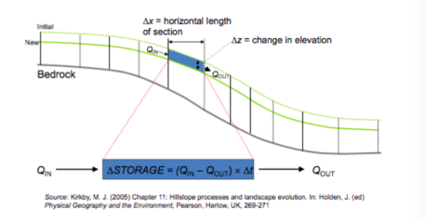
Q = Kc x delta z / delta x - 32How are hill slope sediment budget models created?
- 33What is the rate of erosion mathematically?delta z (change in elevation)/ delta t (time)
(Which also = (Qin - Qout) / delta x (horizontal length of section) - 34What is the rate of erosion controlled by?1. The value of the diffusion coefficient (Kc)
2. The rate of change of slope with distance downslope
This means erosion rate is highest where the slope itself changes most rapidly - 35What is the final rate of erosion defined as when all locational variables (soil type/ amount of rain) are considered?
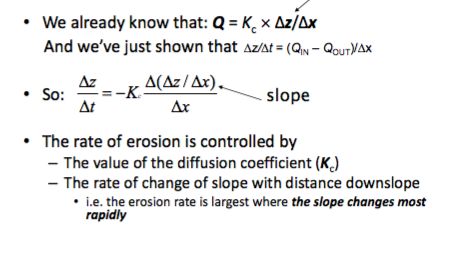
- 36What is meant by the inflection point?- Where the slope changes most rapidly because of its loss of material
- 37What is special about diffusive processes when their hill slope evolution his modelled?- Numerical models can be used to make graphs
- Diffusive processes act to smooth sharp corners (The profile ultimately develops a characteristic form through reduction of slope relief and gradient - the point at which rate is fastest changes with time, slopes smooth off and eventually changes will be made at equilibrium + there's equal balance through the hill slope) - 38How can sediment budget modelling be extended through different geomorphic settings?- Dune migrations - in rivers or airflows (cellular modelling show influence of sediment supply on dune forms and migration dynamics)
- Landscape evolution under changing climate and/or sea levels (Holocene evolution of coastal gullies of IofW) - 39What is the key things that are told by sediment budgeting?- The spatial differences in sediment transport rates (sediment flux) drive erosion/ deposition
- 40What does sediment motion depend upon?1. The FORCES applied by agents of transportation
2. The RESISTING strength of the materials involved
- The forces involved can be significant... - 41What forces influence earth surface materials (Newton)?NEWTONS LAWS OF MOTION
1. An object either remains at rest or continues to move at a constant velocity, unless acted upon by an external force
2. The sum of external forces (F) on an object is equal to the mass (m) of that object multiplied by the acceleration vector (a) of the object: F = ma
3. When one body exerts a force on a second body, the second body exerts and equal force in the opposite direction - 42What forces influence earth surface materials (Lord Kelvin)?KELVIN'S LAWS OF THERMODYNAMICS
1. Energy cannot be created or destroyed
2. The entropy of an isolated system never decreases (sediment will remain in the system unless it is not isolated)
3. Systems which use energy best survive
(laws of probability mean the most likely shape of the system will survive) - 43What are the examples of driving/ motivating forces that influence earth surface materials?1. Shearing forces (fluid or mass moving over the area and shearing off in planes)
2. Gravitational forces - Influences the weight of the object)
3. Lift forces (fluids only)
4. Buoyancy (fluids only) - floating in liquids - 44What are the examples of resisting/ impeding forces that influence earth surface materials?1. Gravitational forces - influencing weight
2. Intrinsic strength - Varies according to material properties (Grain size/ moisture content/ orientation/ gaps) - 45What is meant by shear stress?- The force per unit bed area exerted by the shearing action of a mass moving over a surface by....
1. Glacier motion
2. Water motion
3. Air motion
MOVEMENT BY FLUID FLOW!! - Application of force to the surface - 46How is shear stress calculated?(greek) T = p × g × D × S
*T in pascals
* P = density of material
*g = Gravitational force (always 9.81 m/s2)
* D = Depth of flow
*S = Slope of gradient
As ice is less dense than water ,the shear stress by glaciers is two magnitudes higher than rivers - 47How does fluid lift force work?- There is fluid flow over an object
* High velocity fluid = low pressure
* Low velocity fluid = high pressure
- This makes for a pressure gradient (lift) force over the object - the lift force depends on the velocity gradient over the object - 48What is the difference between weight and mass?Weight - includes gravity
Mass- Amount of the physical product actually there - 49What is the equation for weight?W = mass x gravity
- 50What are the effects of weight having components that act 1.down the slope and 2.normal to the slope?1. THE DOWN SLOPE COMPONENT
Is a driving force (Wd = W x sin of the angle (in newtons))
2. THE 'SLOPE NORMAL' COMPONENT
Is a resisting force (Wn = W x cos of angle (in newtons)) - 51What force dominates on a small slope?Slope normal is the resisting force
- 52What force dominates on steep slopes?The down slope component is largest
- 53How does buoyancy act as a driving force (archimedes principle)?THE ARCHIMEDES PRINCIPLE - An object immersed in a fluid is lighter by an equal amount to the weight of the fluid it displaces
- 54What are the implications of the Archimedes principle?Big objects are light in denser fluid
- 55How is composition of the rock a resisting force?The 'strength' of the rock becomes a variable on how much it can move through 'cohesion'
- The strength of rock/ sediment is derived by 1. electro-chemical bonding (C) - smaller particles have higher cohesion as there are stronger bonds
2. Shear strength (S) - measures the ability to resist against shear stress - 56What is the impact of water on shear strength?- Water acts to lubricate particles, reducing sheer strength and therefore adding to susceptibility of breaks
- 57How is shear strength of earth surface materials calculated?S = (N x tan(circle with line through) + C
- 58What is meant by the threshold for motion of coarse versus fine - grained materials?- The critical value of an applied force required to overcome the resistance to motion
- A particle (or group of...) will start to be transported when this threshold stress is exceeded - 59What is the difference of cohesive materials and non- cohesive materials on predictions for the real world?COHESIVE - (muds/ silts/ clays) - predict the onset/ spatial distribution of land sliding
NON - COHESIVE - (granular materials - sand/ gravel) - Onset of sediment transport in water/ air flows - 60How is the onset of land slides predicted (with reference of factors of safety)?* Driving and resisting forces can be lumped into a 'hybrid index' - the FACTOR OF SAFTEY (F= sum of resisting forces/ sum of driving forces)
- A value greater than one = no change
- The lower the value, the greater likelihood for change
*Often used in engineering to account for slope stability
*Variations in slope stability usually arise because of local change in many parameters - 61How is GIS used to predict the onset of landslides?- Input parameters of the GIS include
1. Soil shear strength (S)
2. Soil thickness (Z)
3. Slope (beta)
4. Pore water pressure (u)
- SHALSTAB is a project that has been used to predict landslides - 62Where do landslides typically form?1. Steep slopes
2. Topographic hollows - thick soils and high soil moisture - 63What is the1. High frequency, low magnitude
OR
2. High magnitude, low frequency
(Rare big events, or lots of smaller?) - 64What were previous ideas were there on magnitude and frequency in terms of geomorphology?- In the 1960s, the idea of 'processes' in geomorphology wasn't common
- The general consensus was that extreme events were those likely to have shaped the earth's surface
- Geomorphology was much broader, with data qualitative for the whole - 65How was Wolman and Miller's paper in 1960 key to changing ideas on magnitude and frequency in geomorphology?- They analysed US rivers and created crude sediment models, showing transports key to landscape evolution and determined at least 50% of sediment transport was by floes of magnitude occurring at least once a year
- Intermediate magnitude events of higher frequency dominate fluvial sediment transport - 66What is a key feature that frequency and magnitude of events depends on?Spatial location
- 67How do observed records representing whole systems tend to change over relative timescales?Data can shown geomorphic processes are temporally viable and there is a spectrum of events of varying magnitude over time
- 68What is meant by uniformitarianism?- Leaders of the geological field argue that the landscapes we see today and the processes by which they are there have occurred throughout the whole of time
- Advocates of the idea include Hutton, Lyell and Playfair
- Uniformity is not only of the process, but of the rate - change is typically slow, steady and gradual
- It requires deep geological timescales - 69What is meant by catastrophism?- Argued it is actually the catastrophic events (low frequency, high magnitude) that have changed landscapes to how we know them today
- Advocated by Georges Cuvier
- The earth is shaped by sudden, violent episodes interrupted by long period of quiescence
- Ideas are based mainly from fossil record indicating repeated mass extinction events
- Catastrophism is sometimes hijacked by creationists - 70What is meant by 'geomorphic work' performed by a river?The amount of sediment transported over a period of time
- The sediment transport rate is a non-linear function of the flow discharge - 71What is the equation for the flow (sediment) transport rate?Qs = (Q - Qc)
Where Qs= sediment transport rate (m3/s)
Q = flow discharge (m3/s)
Qc = Threshold flow discharge to initiate transport (m3/s)
(The Qc threshold of resisting forces has to be breached to allow for movement) - 72What is the dependents and assumptions for sediment transport rates?- Sediment transport rate depends on the capacity and supply
- The normal assumption is there is unlimited supply, so observations will show transport increases rapidly with increasing flow strength - 73What type of graphs can flow frequency and discharge data be converted to?Flow exceeded graphs whereby flow is converted to a percentage of time that discharge is exceeded
They can show the largest flows will occur most infrequently and the smallest flow occur most frequently - 74How are 'effective discharge' graphs created?Flow exceeded curves X curves of frequency of occurrence (probabilities of sediment transports over the same discharges)
- The effective discharge is the peak where most geomorphic work will occur - 75What does the Brahmaputra case study indicate for the differences between magnitude and frequency?*Studied in 1993 by Thorne et al.
* As one of the world's greatest rivers, its affected by monsoon floods every year, but catastrophic floods occurred in 1980s where effective discharge was 38,000 m3/s
*The flooding was seen to move lots of sand in unexpected ways - with the added power of the discharge - 76How does data on the Mekong river show how processes differ to the models when real data is collected and sediment is not unlimited?- Sediment supply was monitored by looking at how much came down river against the discharge
- The falling and rising limbs were measured and separated
- If there was unlimited sediment, the rising and falling limb would be the same, but it was seen the falling limb had less sediment, show sediment is 'used up' - 77What is meant by neo - catastrophism?- Recent work has shown that massive floods are possible and there has been a refocused attention to the significance of larger events
- Palaeo- hydrological studies show cataclysmic events are possible
- Costa (1995) - the effectiveness of individual floods varies as a function of peak stream power and flow duration in relation to thresholds (material resistance) of change - 78What 3 type of possible flood are there?1. Extensive/ low magnitude - Won't exceed the threshold and alluvial erosion is minimal
2. Fairly substantial - Crosses the threshold and has energy available for geomorphic change
3. Short and rapid floods- Can even cross bedrock erosion thresholds - 79What is the implication for bank erosion regarding thresholds?- The annual rate of bank erosion is a function of the accumulated runoff over a threshold (sum of Q - Qc)
- The inter- annual variability ofsum of Q - Qc is likely to be controlled by:
1. Peak flow discharge
2. Duration over the threshold
3. Shape of the hydrographs (multiple peaks? / rising and falling limbs)
This all determines the amount of work done - 80What do megaflood mechanisms indicate are the most destructive flood events?1. Ice dam floods
2. Proglacial lake overflows
3. Tectonic basin overflows
4. Landslide dam breaches
5. Subglacial eruptions
6. Cadera lake breeches
7. Ice jam floods
8. Rainfall
These events have been recorded and are throughout time and great floods can cause complete reshaping of a whole area - 81What other factors have been found (other than size/ frequency and resistance) to control the effectiveness of geomorphic events?- Sequencing
- Recovery and relaxation VS. persistence
- Sediment availability - 82What is surprising when looking at different rivers of the world?They can look completely different in different places of the world as different processes act upon them
- 83How are rivers key agents of denudation?- They are essentially massive conveyor belts of sediments, delivering about 60 tonnes of sediment to the oceans each year (not immediately)
- They are key agents of denudation as they link source zones (active tectonics/ weathering) to sink zones (delta/ floodplains) - 84Where does much of the eroded sediment land up?LANDFORMS - Those sediments eroded from production zones move to temporary zones of storage (fans/ bars)
The storages then operate at a range of spatial and temporal scales
1. Event - individual - boulders moving
2. Years - stay put for a while (sand bars)
3. Centuries/ millennia - floodplain deposits - 85How can diverse geomorphology underpin biodiversity?- Riparian zones comprise <1% of the land area in temperate regions, but support >80% of the species. It comprises of freshwater/ nutrients and habitats and is constantly changing
- Rivers and the habitats they support are very diverse - 86What is meant by the residence time?How long a particle will stay in storage - the timescale can be found by analysing geochemical isotope half times
- 87How can rivers be used as a resource and how can they turn to be hazards?RESOURCE: Mining of sediments/ transport links for city industries/ HEP
HAZARDS: As society encroaches the river system, they can become hazards inc. Bank erosion, causing consumption of land/ infrastructure is threatened (esp. in LEDCs)/ those living close to the floodplain are at risk of flood - 88Is there such thing as a natural river...?- No river in Europe is completely 'natural' they are all managed in some way or have a human influence
- There are many models looking to the river system
1. Ecological
2. Geomorphological
3. Socioeconomic
There is a drive towards sustainable river restoration projects. Ecological models are made - 89What is meant by fluvial geomorphology?Studying sediment sources, fluxes and storage within the river catchment and channel (not just in the channel) over differing timescales
- 90What was the study of fluvial geomorphology like in the early 20th Century?1900- 1950 = Used to be looking at just the small changes. The Davis model of landscape evolution emphasises the stage (time) processes involved
- 91What was the study of fluvial geomorphology like in the 1960s?1960s = Strahler and Chorley - looking at distribution of channels and stream order - how its connected to other areas. Looks at systems and energetics. A useful conceptual model (although lacked mechanistic/ predictive capabilities) was based on empirical data
- 92What was the study of fluvial geomorphology like in the 1970s?- A shift towards empirically quantifying sediment transport and making numerical equation models
- Focused on the physics of the processes
- Measured process rates - 93What was the study of fluvial geomorphology like in the 1990s?- There was a drive to linking processes and landforms
- Increase of computer modelling
- Show the long term river dynamics linked to climate and humans
- Eco- geomorphology and hydromorphology
- There was a change from observation to management as showed climate change was an issue
- Ecogeomorphology began to show how ecology influences sediment transport - 94What was the study of fluvial geomorphology like in the 2000s?- There is renewed interest in process- form interactions due to new measurement techniques
- Ability to collect and process high resolution data (new computer programming)
- Flows showed helical vortices rather than purely straight lines
- Advances in numerical (coded) modelling can produce realistic river forms/ features and allow 'what ifs' to be analysed - 95What are the 3 different ways of conceptualising rivers?1. MORPHOLOGICAL SYSTEMS - Examining morphological properties of landforms or landscape elements (bank to bar to pool to riffle to...) it shows they can all be interconnected
2. CASCADING SYSTEMS - Examining movements of mass and flows of energy through the landscape (sediment input to landform to sediment output)
3. PROCESS-RESPONSE SYSTEMS - Examining interactions between morphological and cascading systems and examining the relationships between adjustments in process and form. Morphological and cascading systems alone don't account for 'what ifs' - 96How can rivers be expressed as mathematical models (navier stokes)?Mathematical representations of physical processes provide in depth models
NAVIER STOKES - Describes how velocity/ pressure and density of a moving fluid are related in 3D
They provide a basis for current hydrodynamic models - 97What makes for deposition and erosion?Deposition - Sediment in > sediment out
Eroision - Sediment out > sediment in
1.Supplies from - Bank failures/ lateral bank collapse/ input from upstream
2. Lateral transfers of sediment
3. Outputs - 98What is meant by Lane's balance?- A formalised version of inputs and outputs causing erosion or deposition
- A proportionality between sediment supply and sediment output to show aggradation or degradation
- Processes work to try and keep at equilibrium
- Qs.D is proportional to Q.S
(Q= discharge, S= channel slope, D= particle size, Qs = sediment load) - 99What are the 4 types of drainage basin?1. Dendritic - Braided
2. Rectangular- has fractures
3. Radial- from areas of very high topography and radiates down from the central point
4. Trellis - inlines - 100What is important about the drainage basin?It is a fundamental geomorphic unit
Basin scale characteristics control the inputs and outputs of water and sediment into the river network
Where the basin is on the Earth's surface influences types and rates of processes - 101What is sediment flux in a river a product of?Characteristics of the drainage basin affects sediment flux
1. Rates of sediment production (supply)
2. Rates of sediment movement (transport)
3. Connectivity - between supplies and transport components of the landscape - 102What are the 3 types of channel that influence slope processes and connectivity of rivers?GORGES - Fully coupled - delivery of slope material to the channel in all flows
CONFINED CHANNELS - Partially coupled - delivery of slope material to channels. Spatially discrete and sporadic activity. Acts as limited storage as pockets of the floodplain can stop sediment getting into the channel instantaneously
UNCONFINED CHANNELS - Uncoupled - delivery of slope material to channel at high flows or confluences. Storage on the floodplain - 103What is the scientific view of sediment flux?- It is a key measure of geomorphic work
- It is a key component of landscape evolution
- Creates valleys, floodplains and channel morphology
- Creates and maintains physical habitats and associated ecology - 104What is the management view of sediment flux?- Creates hydraulically insufficient channels
- Source of expensive maintenance
- Can have negative impacts for stream biota
- Essential for the creation of habitats
- Highly relevant for river and floodplain restoration
- Sediment clogs channels and makes them more inefficient - 105What are the two things that determine sediment loads?1. Energy of force exerted by the flow
2. The amount of sediment available for transport - 106What is total load and what are the different ways of defining it?TOTAL LOAD - The amount of sediment a river is transporting
- Definition by PROCESS - 1. Bed load or 2. Suspended load
- Definition by SOUCRE - 1. Bed- material load - Proportion of sediment originating from the bed itself or 2. Wash load - coming in from areas other than the channel (run off) could even flow all the way without ever touching the bed - 107What controls are there of bed load transport?1. Energy
2. Bed load material type - sediment size and arrangement on the bed (resistance to movement - force exerted over bed by the moving water)
3. Upstream supply of sediment
4. Connectivity to the upstream sediment supply - 108What are the different mathematical models on bed load transport?There are too many factors involved to be able to actively quantify sediment transport
There are therefore many models that incorporate different things (Bagnoid model is the one with the best fit to actual data) - 109What are the different dimensions and ways of looking at river channel form?1. Cross - section - can take widths/ depths /wetted perimeters
2. Planform - The birds eye view (width of the floodplain/ size of the meanders)
3. Long profile - Shows knickpoints/ pools/ riffles - 110What factors control river channel form?1. Driving variables - Discharge and inflow sediments
2. Boundary characteristics - The physical conformities of the channel
3. Channel form - way of looking at them - 111What happens as you move downstream?DECREASE - Bed material grain size and channel gradient
INCREASE - Stored sediment, stream flow, stream power - 112What characteristics of the river system will make for the highest available powers?High slopes
High discharges
(Although higher discharge downstream will coincide with lowering slopes) - 113What are the 4 main types of categorising a river?1. Meanders
2. Braided
3. Anastomising
4. Anabranching - 114What are the main characteristics of a braided channel?- High sloped location (glacial/ highland areas)
- Multiple channels
- Active channels
- Temporary islands
- High bed loads - 115What are the main characteristics of a Anabranching channel?- Have permanent islands
- Much like braided
- More in lowland areas, where there are large rivers with small bed loads - 116What are the main characteristics of a anastomosed channel?The world's largest rivers with branches 100s of Kms before rejoining
3 or 4 main channels that seem like single rivers if on a small spatial scale
Permanent islands - 117What are the main characteristics of a meandering channel?Higher sinuosity = more meandering channel
Meandering occurs across a range of discharges but generally at lower slopes - 118What are the main characteristics of the world's largest rivers compared to the normal rivers?- Large rivers act very very differently, not just because of higher discharges - they have characteristically much lower changes in gradients, which is a major driving force of the water itself. Variable, seasonal flows are also important
FLOODPLAIN INTERACTIONS ARE VERY IMPORTANT....
- They are key to transfer of sediment and water to the channel/ floodplain
- Large river floodplains are complex and don't act as one unit (some areas very active, others bypassed completely)
- The rivers carve their own topography after flood events (topographic hollows)
- Stores and sources of sediment - 119What do channels adjust in response to?- Changes in sediment supply and energy (natural processes or human disturbances)
- Adjustment processes and style vary between river types - 120What is Hey's 'Nine Degrees of Freedom' for alluvial rivers?An alluvial (sediment) river can adjust its average baneful through
1. Width
2. Depth
3. Maximum depth
4. Velocity
5. Slope
6. Sinuosity - meanders
7. Meander arc length - difference between two inflection points
8. Bedform amplitude
9. Bedform wavelength - 121What is the case study regarding channel adjustment for the Brazos river, USA?- One of the most heavily impacted rivers in the US
- Adjustments to restoration schemes
- A series of dam removals
- Incision caused by upstream knickpoint propagation - changes to the base levels
- Rapid changes in gradients that then move upstream (deepening channel - moves 30m across channel). Accretion at the bank (as river gets deeper, doesn't need to be as wide)
- Lower reaches of the Brazos are yet to adjust
- Adjustments are seen to be spatially and temporally variable - 122What is the case study regarding channel adjustment for the Cueno Creek (California)?- Steep gravel- bedded stream (around 3% slope)
- Small upland catchment area
- Transitions between straight and braided planforms - vulnerable to run -off process
- Series of human and natural disturbances - cleared for grazing and farming between 1946 - 1966
- Large floods of 1955, 1964, 1999
- Combination of floods/ land clearances caused by widespread mass failures and sediment delivery to the channel
- Rivers adjust to the new sediment regimes, but there are widespread mass failures
- Sediment increases after the floods - 15-20 years for it to erode back - 123What can studies of channel responses to sediment supplies show?- There are major changes in sediment storage and transport rates during aggradational and degradation phases
- Aggregation increases channel gradient (degradation decreases)
- The response is non- linear - storage isn't linear to increased sediment flux
- Variations in sediment transport were associated with changes in channel morphology - 124What point on the slope is always preferentially eroded?Point of the highest slope
- 125What are the mechanisms of lateral adjustment?- Hydraulics will determine scour at the bank
- Meandering channels are highly active
- Bank erosion processes determine sediment supply to the channel
- Hydraulics in the bend will sort the sediments
- Downslope component of weight dominates heavier particles
- Fluid drag and lift dominate for finer particles - 126Where are the fastest and slowest areas of the meander?Outer bank is the thalweg - Finer deposits deposited only during overbook floods
Inner bank is shallower - coarser deposits with distinct vertical gradations in grain size laid down in channel/ point bars
Water flowing helically as well as up and down in the water column
Greater flow from inner bank to bed - 127What is the significance of elevation of water around a bend?- Outside is higher than the inside
- This makes for stress and energy changes
- Undercutting the bank
- Bank collapse will then protect the bank, leading to a period where bank erosion may decrease
- Fine material is moved first, towards the inner bend and creates point bars - 128What can happen to very fine soils?Fine sediment can be deposited on flood plains
- Meanders don't migrate in a straight way and they are driven by different processes - 129How do braided channels adjust (braid bars)?- Braided channels have braid bars
- Braid bars have a confluence/ diffluence unit that cause channel change
- Depth changes alter velocity and deposition patterns
- Deposition for fine materials at sides of bar
- Erosion occurs at the banks
- Bars continue to grow
- Water can flow back up towards the bar when meeting in the head of the bar, with smaller spatial and temporal scale meanders - 130What is the history of wood in rivers?- Wood was once more prevalence in rivers
- There has been a change to recognise the influence of wood on river processes
- Wood is an obstacle by fallen trees
- Historically biggest cause of wood adjustment
- Even if it doesn't span the channel, it can trap sediment + cause changes in flow
- Cohesion to soil and sediment to start colonising - 131What are the factors that change the role of wood in the river?1. SIZE OF THE WOOD - smaller pieces are more mobile and shorter lived
2. SIZE OF THE STREAM - (Wood: stream ratio) distinguishes between wood blocking the river (jams/ dams) and wood that influences bar formation and channel processes - 132How does channels adjust to climate change?GLACIAL CYCLES - Diurnal/ seasonal temperature fluctuations. High rates of weathering and sediment production leads to aggradation
WARMING - Para-glacial activity causes outburst floods, increasing discharge and causing thermal weathering with incision into valley fill
WARM PHASES - Rainfall dominated events, where vegetation cover is smaller, making for reduced erosion rates and allowing incision to valley fill
(Braiding on colder temperatures. Aggregation/ degradation cycles seem to map with glacials) - 133What are the arguments for channels to be in equilibrium?- Lane's balance model (1955) are based on an assumption of equilibrium
- Rivers adjust to equalise sediment throughput over a given distance (no net change)
- The concept of equilibrium pervades much of geomorphology and increasingly timescales of study reveal non- equilibrium tendencies and increased complexity from which large scale features emerge (terraces/ floodplains) - 134How have civilisations in the past tried to tame the environment and build infrastructure to help build resilience to climatic variability in rivers?- Egyptian civilisation used the Nile for irrigation
- Ancient Angkor built an intricate network of irrigation channels and reservoirs. Stored water for the dry season (maintain for cultivation)
- Babylonians were renowned for their management of landscapes
- Forest clearances and channel modifications by the roman empire to transport supplies around Europe. Let the floodplains drain - 135When did forest clearance/ floodplain clearance of channel modification/ switch to restoration occur?Forest clearance - 4,200 years BP
Floodplain clearance/ channel modification - 2,000 years BP
Restoration - 10 years BP - 136What types of change are there to the volume of water and the timings of flows?1. Land cover changes - Deforestation/ agriculture/ urbanisation
2. Water use - Municipal (domestic use)/ irrigation
3. Impoundment - dams
4. Climate change - anthropogenic climate change variable)
5. Natural climatic variability - 137What is meant by deliberate interventions- Have the specific intention of altering hydrological characteristics
- Effects can often be specified exactly
- Can be wider reaching than first thought - 138What are the inadvertent interventions?- An action can have unintended or inadvertent or 'unimportant' effects on streamflow
- The effects can be difficult to specify
Deliberate interventions can have inadvertent impacts - 139What are the reasons for tree cover to be cleared?- Land clearance for agriculture
- Fire
- Forestry
- Urbanisation
This means removals of trees = removal of interception/ binding of soils - 140What is meant by the 'conventional' approach and the 'minimum impact' approachCONVENTIONAL - Clear felling, extraction of logs by tractor, and clearance by burning - 20% effect of run off
- Affects both water balance and run off generation processes
MINIMUM IMPACT - Clear felling, manual traction, no burning
- 8% effect of run off
- Affect just the water balance - 141What are the 3 main effects of deforestation?1. Increase in run off - Reduced interception/ reduced evaporation
Effect varies with vegetation type and climate regime. Different plant types have different impacts on resistance
2. Peak flows - Deforestation tends to affect average/ small floods rather than the large ones
3. Change in the timings of floods - largely determined by the deforestation process - particularly the construction of roads - 142How has agriculture impacted on rivers?- The most extensive form of land surface manipulation
- Among the oldest form of land surface manipulation
- In most cases started with clearance of existing vegetation
- Major abstractions for irrigation (taken from reservoirs)
- Depends on some form of modification to the soil (drainage/ nutrient content). Increase in tilling/ adding nutrients changes the river. Mass wasting more common (clogging of habitats/ eutrophication)
- Increased soil erosion/ slope instability/ drainage - 143What are the effects of urbanisation on rivers?- There is a more rapid response to rainfall
- Impermeable surfaces/ soil compaction = increased run off (no interception/ infiltration) - 144What are the impacts of mills and weirs?- From the industrial revolution
- On construction of mill, a secondary channel has to be cut (changing the planform in the amount in the channel)
- There are planform modification (new channels/ smaller flows in existing channels)
- Barriers to sediment (bedload) transport (breaks in connectivity)
- Storage zones for sediment and associated pollutants
- Barriers to migratory species - 145How do dams impact on river regulations?- Change the flow regime
- Change the ability of plankton growth
- Dams stop fish migrating back to spawning zones - 146What are the impacts of channelisation?- Direct modification to the physical form of the river channel
- Often part of an arterial drainage scheme
- River will want to meander naturally - maintenance is always required - 147What is meant by river maintenance?- Action taken to preserve the design performance of a river channel or to prevent erosion
- Channelisation is typically a one off, maintenance is a regular disturbance of the river environment - 148What is the incised channel evolution model?- Initial incision due to the effects of bed -level lowering (headward - migrating incision)
- Degradation destabilises the banks and leads to mass- failure and widening
- Containment of flood flows in channel increased stream power - accelerates incision
- Sediment supplied from incision and bank failure upstream is deposited downstream (feedback and recovery) - 149What are sediment transport and infrastructure?- Sedimentation of reservoirs
- Bridge blockages
- Bank erosion - loss of land and property
- Bridge scour - communications - 150What are the human impacts from river changes on biodiversity?1. Changes in the flow and thermal regimes
2. Loss of in- stream habitat
3. Loss of food sources
4. Competition with stocked fish
5. Sedimentation (organic/ inorganic)
6. Introduction of toxins: Hormone disrupters (Atrazine), pesticides
7. Migratory impediment
8. Over fishing
9. Changes in acidity
10. Loss of genetic diversity - Reducing biodiversity can force an evolutionary route - 151What have been the changes to the re-conceptualisation of river management?50s/ 70s - Nature under control
70s/ 90s - Towards a more natural channel
2004+ - Towards floodplain and catchment ecosystem management - 152What are the key requirements for restoration practices?1. CONSERVATION LED
2. SPECIES LED
3. INTUITIVE/ EXPERT- BASED DESIGN
4. FEATURE BASED - design and implementation
5. SMALL SCALE reach - based
6. BIASED TO LOW - COST OPTIONS - cost:benefit approaches - 153How does climate change have an effect on rivers?Climate changes impact precipitation/ temperatures
Shifts to seasonal regimes that are more dynamic and ever changing
Changes in climate due to climate change are likely to have an effect on river flows and sediment transport in the future - 154What is the history of researching aeolian transport?- First researchers were undertaken by explorers, with diaries of observations
- Bagnold was the father of modern aeolian research (Egypt/ Namibia) - 155What are the key points of aeolian transport?- In mountainous areas with sand
- Deserts will have sunsets and rises
- There are many of these arid/ semi- arid environments worldwide
- There are many different animals associated with desert animals worldwide - 156What is needed to move sand sediments?WIND
- It acts as the force on the surface
- There is an increase in wind speed with height, as there is less interaction with the roughness of the surface - 157What are the grain entrainment forces for airflow over sand?- Lift
- Drag
- Cohesion
- Weight - 158What is shear velocity?Shear stress/ air density
It relates directly to the wind speed
Thresholds and experiments are carried out in wind tunnels of in the field - 159What is the main transport process for aeolian transport?SALTATION
- 160What forces determine the saltation trajectory?- Gravity
- Aerodynamic drag
- Magnus effect
- Aerodynamic lift - 161What does transport depend on?The shear velocity
- Sand transport rate is not linear and is proportional to the cube of shear velocity - 162What two ways are there to reduce aeolian sediment flux?1. Preventing sediment from moving
2. Protecting the surface - 163What factors can cause resistance for the substrate?- Increased shear velocity is required under moist conditions - wet surfaces have minimal transport as moisture changes the bonds and holds grains down (Even for very arid coastal areas that have sea fogs)
- There is reduced flux with increased roughness
- Vegetation influences transport pattern/ increased roughness and the sediment trap - 164What are streamers?Sand movement isn't uniform - it follows the turbulent wind patterns and can create the landform streamers
- 165What is a Barchan dune?- Has a crescent shape
- There is a crest at the top
- Has a low sediment supply
- Horns point in downwind (growth) direction
- Created by unidirectional winds - 166What is the integral width of a dune?The distance between the two horns
- 167What are sand strips (how do dunes develop)?Elementary forms of the dune. Starts with a 'patch/ stretch', then makes a protodune
- Development of a flow pattern allows for dune migration
- Saltation will take the sediment up and over the crest - 168What is meant by avalanching?- There is movement in grain flow that causes an avalanching effect
- The dune is mobile and it is gravity driven
- The angle of repose is around 30 - 35'
- The dunes migrate forward
- Erosion occurs close to the top, large deposition below (hourglass shaped) - 169What is meant by the crest?The highest point of the dune
- 170What are the differences between the lee and sloss slopes?- The lee slope is of finer, unconsolidated material. Angle around 30 -35'. Soft as a flow separation zone exists
- The stoss slope is harder - 171What is the importance of the real world for looking at geomobility rates?Can fast track time and see if there will be any infrastructure damage
- 172What is a barchanoid?When barchans are together and touching
Formed from unidirectional winds - 173What are transverse dunes?- Where no individual barchans are seen
- Curvy
- Have an increasing sand supply compared to barchans - 174What are linear dunes?- Have no presentic features
- Straight
- Bimodal winds - when different directions dominate at different times of year - 175What are star dunes?- Have a peak at the top
- Spurs come out in many directions
- Formed by multimodal winds - 176What affects the shape of the dunes?1. Wind regime - Dunes will get bigger and migrate with wind directions changing throughout the year
2. Wind variability - Spokes of sand rose (few for barchans and many for star dunes) - 177How is wind direction variability measured?- The transport Rose- Fryberger method
- Takes annual transport drift potential and gives 16 possible wind directions
- Theres a transport threshold
- And the ratio of dirt potential to drift potential sum
(Annual rate of potential sediment drift is proportional tot he average horizontal wind speed at 10m squared times the frequency of transport) - 178What is a nebkha dune?Where sand will accumulate around a bush
- 179What dune types are there?1. Blowout
2. Parabolic
3. Nebkha
4. Foredune
5. Linear - 180What type of dune is created through different vegetation ratios?
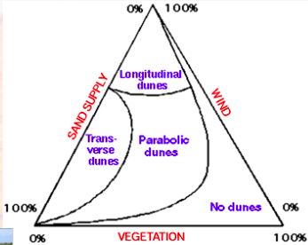
- 181What are depositional landforms of dunes?- Depends on the sand sized particles on different spatial scales. Sand organises itself to different patterns in dune fields
* Ripples
* Draas
* Dunes
* Ergs - 182What are the studies for dune migration?*Namibia - a 2005 slipface moved 130m by 2014 (it was 9.7m high, so 14.4 m/yr)
*A 2001 slipface moved 570m by 2014 (it was 3.3 - 4.5m high, 43.8 m/yr) - 183How does size of the dune affect mobility?- Smaller dunes travel faster
- 184What are large dunes classified above?300m + in height
- 185How can the system be limited for aeolian transport?1. TRANSPORT LIMITED - High sediment availability. Low wind strengths. Dependant on the winds. Creates small and skinny dunes
2. SUPPLY LIMITED - Low sediment source. Wind above threshold
3. SEDIMENT AVAILABILITY - Sediment availability for 'surface boundary'. Can the sediment even be moved? Moisture, vegetation, gravel, crusts. - 186How can dunes move?1. MERGING - Barchans themselves can shift/ change sediment supply to each other. They can merge to form larger dunes and coalesce
2. SHEDDING - from horns and make small barchans. Depending on where they hit, the smaller barchans will change the sediment balance and creates new patterns - 187What environmental conditions affect the transport of dunes?Wind regime
- Understanding distributions requires reading the landscape, by looking at wind conditions
- Can tell the wind direction by looking for the leeward slope (thin dark sections) - 188What type of patterns will bimodal winds typically produce?- Costal and mountainous conditions together can make for bimodal conditions
- There are typically lined up shaped dunes
- Either transverse or linear
- Crests of dunes line up in gross bedform linear conditions - 189What is the difference that can be seen between linear and transverse dunes?Linear dunes have 'y' junctions and are very straight. In linear dunes, the resultant arrow of wind direction is parallel with the crest line
Transverse are more curvy - 190What is a simple dune?Individual dunes
Spatially separated - 191What are compound dunes?- Two or more dunes of the same type that are superimposed
- Smaller barchans can form on top of very large ones - 192What are complex dunes?- Two or more dunes of different types that are superimposed
- 193How do dune fields self - organise?- Dune field response through time
(change in wind regimes create complex patterns)
- Dune fields can be on the edge of different categories
- Identification of patterns in present conditions have to be extrapolated back to see climates affects on them many years ago - 194What type of dunes indicate its older?Those that are bigger and more spaced out
- 195In what conditions are dunes found?- Drylands, where moisture content is poor
* Areas between 25 and 35 degrees N and S
* Continental interiors (Gobi) - less moisture as not near the oceans
* Rainshadow
* Coastal and polar deserts - 196What types of deserts are there?*Stony, sand, hard rock, salt lakes
- 197Where are there sand dunes on Mars and why is there other ?- In craters in dune fields
- For understanding geomorphology, material, wind patterns, controls
- For space ship design, landing mechanisms, environmental issues, interpreting results - 198—
Informationen
- Beschreibung
- Karteikarten am Geog 1002, erstellt von Pippa Holman am 26/01/2016.
- Erstellt von
- Pippa Holman
- Aufrufe
- 3
- Bewertung