
Karteikarten
Geography
Karten in diesem Stapel (15)
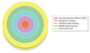
- 1What are the two types of land-use model?Burgess Model (MEDC)
Hoyt Model (LEDC)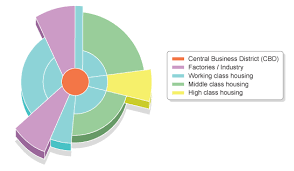
- 2Characteristics of rural urban fringeFarms + Shanty Towns
- 3Characteristics of the Outer SuburbsDetached housing- big gardens which attract families
- 4Characteristics of the Inner SuburbsSemi detached housing and average sized gardens
- 5Characteristics of the Inner CityTerraced housing and high rise flats
- 6What is urbanization?The increase of the proportion of people living in the city- resulting in growth
- 7Name 4 solutions of congestion1. Park and Ride
2. Ring Roads
3. Car Share
4. Walking Bus - 8How has BedZED London become more sustainable? (5 examples)1. Building materials that naturally capture the Sun's heat+light (they're very thick)
2. Wind driven ventilation (chimney)
3. They have a scheme called Car-share. This reduces congestion and pollution
4. Electric from solar panels
5. Passive solar gain - 9What is a brownfield site?A site that has already been previously built on
- 10Give an example of a brownfield siteStoke on Trent- The Potteries
- 11Different proposals for this brownfield site1. Green proposal- city farm
2. Economic proposal- shopping center
3. Social proposal- young families getting in the property ladder
4. Enterprise and arts proposal- creative workshop
5. Amenity proposal- Leisure center - 12Problems and solutions of squatter settlements in DharaviProblems
Cramped and polluted water
80% of the people in squatter settlements earn less than two euro a day.
60% of the people that live in Dharavi live in squatter settlements
Solutions
Self help schemes
Site and service schemes - 13Difference in urbanization between LEDC's and MECD'sLEDC's are becoming urbanized more recently because MEDC's became industrialized during the Industrial Revolution. MEDC's urbanization has slowed down over the years
- 14What is City Challenge?A bottom-up approach to community based improvements in Inner city areas
- 15—