
Karteikarten
Geography TRF revision
Karten in diesem Stapel (14)
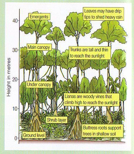
- 1How many layers are there in the rainforest, what are they?4:
Shrub layer, Under Canopy, Canopy and emergent - 2Diagram of forest layers
- 3What are the worlds main ecosystems?Rainforest, Tundra, Deciduous forest, Desert, Savannah, Plains / grassland
- 4On a climate graph, what do the x, y and z axis contain?X = temperature
Y = month
Z = rainfall (mm) - 5What are the key features of the TRF?Evergreen, four distinct layers, wet but not dry season
- 6What is the average temperature of the TRF?21 - 27 degrees centigrade
- 7Where are the worlds major tropical rainforests located?Brazil, Madagascar, Asia, Centeral America, Africa, Austrilasia
- 8List several methods of sustainable developmentSeletive logging, replantation, reusing, recycling, education, reducing availablility
- 9What are some of the effects of deforestation?Ecosystem collapse, loss of unique species, increased Carbon Dioxide levels resulting in global warming, less oxygen in the atmosphere, collapse of native culture
- 10What are some of the reasons for deforestation?Money gain, clearing space for infrastructure, clearning space for transport, gaining access to mineral rich areas, agriculture
- 11List some adaptions of plants on the forest floorBig leaves to gain more sun for photosythesis, angeled leaves / drip tips to let water run off reducing plant damage
- 12What are some adaptions of emergent?Buttress roots to help stabilise, big leaves for the most sun, big branches to help support the massive leaves
- 13What adaptions are common in rainforest animals?Strong limbs to climb trees, camouflage or incredibly colourful to show obvious threat, behavioural adaption to be nocturnal
- 14What is the rainfall levels of the TRF on average per year?200 to 1000 cm
Informationen
- Beschreibung
- GCSE Geography GCSE Karteikarten am Geography TRF revision, erstellt von Oliver Faragher am 14/05/2017.
- Erstellt von
- Oliver Faragher
- Aufrufe
- 184
- Tags
- Bewertung