
Mindmap
Rivers
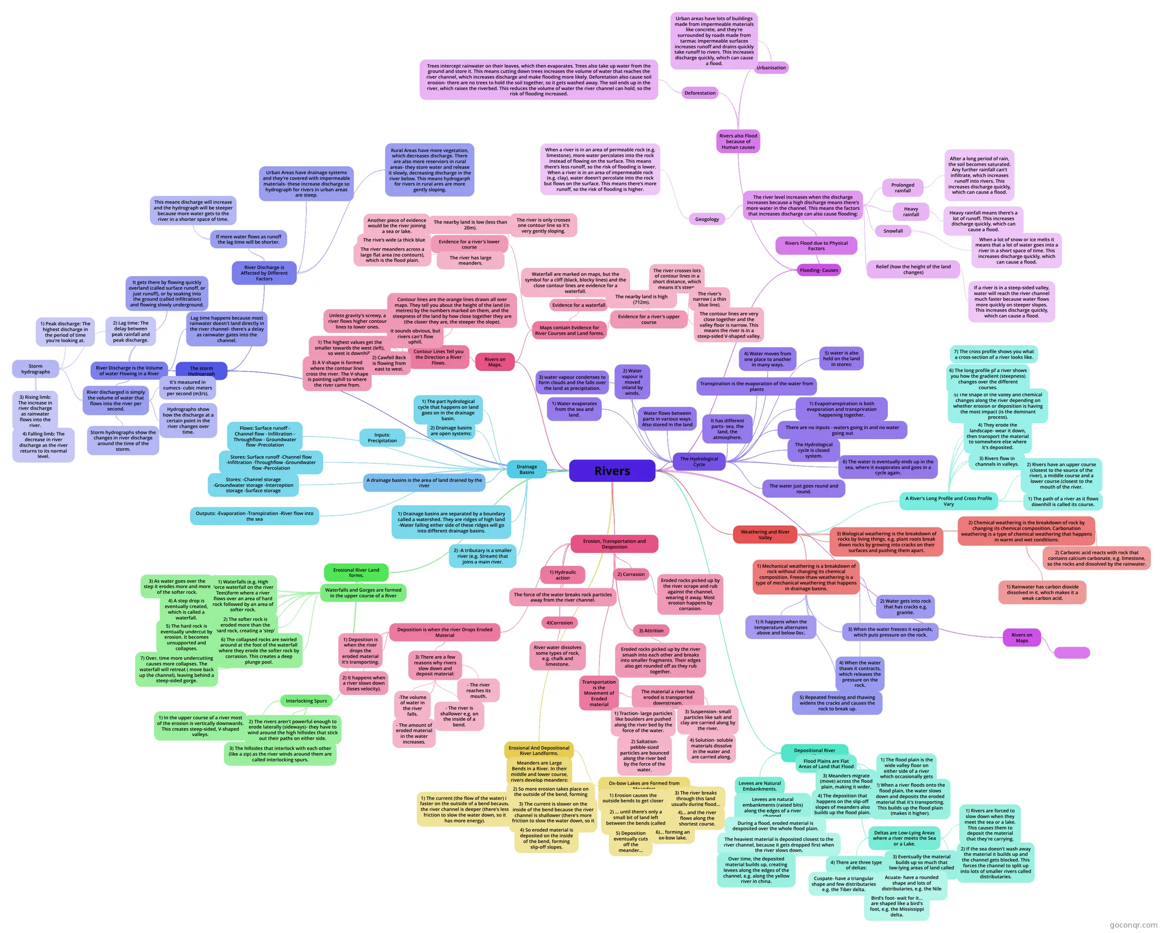
Mind map: Rivers geography
Inhalt der Mindmap
Rivers
The Hydrological Cycle
- It has different parts- sea, the land, the atmosphere.
- Water flows between parts in various ways. Also stored in the land
- The Hydrological cycle is closed system.
- There are no inputs - waters going in and no water going out
- The water just goes round and round.
- 1) Water evaporates from the sea and land.
- Transpiration is the evaporation of the water from plants
- 1) Evapotranspiration is both evaporation and transpriration happening together.
- 2) Water vapour is moved inland by winds.
- 3) water vapour condenses to form clouds and the falls over the land as precipitation.
- 4) Water moves from one place to another in many ways.
- -Infiltration is when water soaks into the soil. -Percolation is when water moves vertically down through soil and rock. -Groundwater flows is when water in rock flows downhill -Throughflow is when water is in the soil flows downhill. -Surface runoff- is when water flows underground -Channel flow is the flow of water in a river.
- 5) water is also held on the land in stores:
- - Channel storage is when water is held in a river. - Groundwater storage is when water is stored underground in soil and rock. A rock that store water is called an aquifer e.g. chalk. - Interception storage is when water lands on things like plants leaves and doesn't hit the ground. -Surface storage is when water is held in things like lakes, reservoirs and puddles.
- 6) The water is eventually ends up in the sea, where it evaporates and goes in a cycle again.
Drainage Basins
- A drainage basins is the area of land drained by the river
- 1) The part hydrological cycle that happens on land goes on in the drainage basin.
- 2) Drainage basins are open systems:
- - There are inputs of water to drainage basins. -Water flows through them and is stored in them. - There are outputs of water from drainage basins.
- Inputs: Precipitation
- Flows: Surface runoff - Channel flow - Infiltration - Throughflow - Groundwater flow -Precolation
- Stores: Surface runoff -Channel flow -Infiltration -Throughflow -Groundwater flow -Percolation
- Stores: -Channel storage -Groundwater storage -Interception storage -Surface storage
- Outputs: -Evaporation -Transpiration -River flow into the sea
- 1) Drainage basins are separated by a boundary called a watershed. They are ridges of high land -Water falling either side of these ridges will go into different drainage basins.
- 2) -A tributary is a smaller river (e.g. Stream) that joins a main river.
- - The source is where a river starts, usually in an upland are (e.g. mountains). - A confluence is a point where two rivers join. -The mouth is where a river flows into the sea or a lake.
Weathering and River Valley
- 1) Mechanical weathering is a breakdown of rock without changing its chemical composition. Freeze-thaw weathering is a type of mechanical weathering that happens in drainage basins.
- 1) It happens when the temperature alternates above and below 0c (the freezing point of water). 2) Water gets into rock that has cracks, e.g. granite. 3) When the water freezes it expands, which puts pressure on the rock. 4) When the water thaws it contracts, which releases the pressure on the rock. 5) Repeated freezing and thawing widens the cracks and causes the rock break up.
- 1) It happens when the temperature alternates above and below 0oc.
- 2) Water gets into rock that has cracks e.g. granite.
- 3) When the water freezes it expands, which puts pressure on the rock.
- 4) When the water thaws it contracts, which releases the pressure on the rock.
- 5) Repeated freezing and thawing widens the cracks and causes the rock to break up.
- 2) Chemical weathering is the breakdown of rock by changing its chemical composition. Carbonation weathering is a type of chemical weathering that happens in warm and wet conditions:
- 1) Rainwater has carbon dioxide dissolved in it, which makes it a weak carbon acid.
- 2) Carbonic acid reacts with rock that contains calcium carbonate, e.g. limestone, so the rocks and dissolved by the rainwater.
- 3) Biological weathering is the breakdown of rocks by living things, e.g. plant roots break down rocks by growing into cracks on their surfaces and pushing them apart.
- A River's Long Profile and Cross Profile Vary
- 1) The path of a river as it flows downhill is called its course.
- 2) Rivers have an upper course (closest to the source of the river), a middle course and a lower course (closest to the mouth of the river.
- 3) Rivers flow in channels in valleys.
- 4) They erode the landscape- wear it down, then transport the material to somewhere else where it's deposited.
- 5) The shape of the valley and chemical changes along the river depending on whether erosion or deposition is having the most impact (is the dominant process).
- 6) The long profile pf a river shows you how the gradient (steepness) changes over the different courses.
- 7) The cross profile shows you what a cross-section of a river looks like.
- 1) Mechanical weathering is a breakdown of rock without changing its chemical composition. Freeze-thaw weathering is a type of mechanical weathering that happens in drainage basins.
Erosion, Transportation and Despostion
- 1) Hydraulic action
- The force of the water breaks rock particles away from the river channel.
- 2) Corrasion
- Eroded rocks picked up by the river scrape and rub against the channel, wearing it away. Most erosion happens by corrasion.
- 3) Attrition
- Eroded rocks picked up by the river smash into each other and breaks into smaller fragments. Their edges also get rounded off as they rub together.
- 4)Corrosion
- River water dissolves some types of rock, e.g. chalk and limestone.
- Transportation is the Movement of Eroded material
- The material a river has eroded is transported downstream.
- 1) Traction- large particles like boulders are pushed along the river bed by the force of the water.
- 2) Saltation- pebble-sized particles are bounced along the river bed by the force of the water.
- 3) Suspension- small particles like salt and clay are carried along by the river.
- 4) Solution- soluble materials dissolve in the water and are carried along.
- The material a river has eroded is transported downstream.
- Deposition is when the river Drops Eroded Material
- 1) Deposition is when the river drops the eroded material it's transporting.
- 2) It happens when a river slows down (loses velocity).
- 3) There are a few reasons why rivers slow down and deposit material:
- -The volume of water in the river falls.
- - The amount of eroded material in the water increases.
- - The river is shallower e.g. on the inside of a bend.
- - The river reaches its mouth.
- 1) Hydraulic action
Erosional River Land forms.
- Waterfalls and Gorges are formed in the upper course of a River
- 1) Waterfalls (e.g. High Force waterfall on the river Tees)form where a river flows over an area of hard rock followed by an area of softer rock.
- 2) The softer rock is eroded more than the hard rock, creating a 'step' in the river.
- 3) As water goes over the step it erodes more and more of the softer rock.
- 4) A step drop is eventually created, which is called a waterfall.
- 5) The hard rock is eventually undercut by erosion. It becomes unsupported and collapses.
- 6) The collapsed rocks are swirled around at the foot of the waterfall where they erode the softer rock by corrasion. This creates a deep plunge pool.
- 7) Over, time more undercutting causes more collapses. The waterfall will retreat ( move back up the channel), leaving behind a steep-sided gorge.
- Interlocking Spurs
- 1) In the upper course of a river most of the erosion is vertically downwards. This creates steep-sided, V-shaped valleys.
- 2) The rivers aren't powerful enough to erode laterally (sideways)- they have to wind around the high hillsides that stick out their paths on either side.
- 3) The hillsides that interlock with each other (like a zip) as the river winds around them are called interlocking spurs.
- Waterfalls and Gorges are formed in the upper course of a River
Erosional And Depositional River Landforms.
- Meanders are Large Bends in a River. In their middle and lower course, rivers develop meanders:
- 1) The current (the flow of the water) is faster on the outside of a bend because the river channel is deeper (there's less friction to slow the water down, so it has more energy).
- 2) So more erosion takes place on the outside of the bend, forming river cliffs.
- 3) The current is slower on the inside of the bend because the river channel is shallower (there's more friction to slow the water down, so it has less energy).
- 4) So eroded material is deposited on the inside of the bend, forming slip-off slopes.
- Ox-bow Lakes are Formed from Meanders
- 1) Erosion causes the outside bends to get closer ...
- 2) ... until there's only a small bit of land left between the bends (called the neck).
- 3) The river breaks through this land usually during flood...
- 4)... and the river flows along the shortest course.
- 5) Deposition eventually cuts off the meander...
- 6)... forming an ox-bow lake.
- Meanders are Large Bends in a River. In their middle and lower course, rivers develop meanders:
Depositional River Landforms
- Flood Plains are Flat Areas of Land that Flood
- 1) The flood plain is the wide valley floor on either side of a river which occasionally gets flooded.
- 2) When a river floods onto the flood plain, the water slows down and deposits the eroded material that it's transporting. This builds up the flood plain (makes it higher).
- 3) Meanders migrate (move) across the flood plain, making it wider.
- 4) The deposition that happens on the slip-off slopes of meanders also builds up the flood plain.
- Levees are Natural Embankments.
- Levees are natural embankments (raised bits) along the edges of a river channel.
- During a flood, eroded material is desposited over the whole flood plain.
- The heaviest material is deposited closest to the river channel, because it gets dropped first when the river slows down.
- Over time, the deposited material builds up, creating levees along the edges of the channel, e.g. along the yellow river in china.
- Levees are natural embankments (raised bits) along the edges of a river channel.
- Deltas are Low-Lying Areas where a river meets the Sea or a Lake.
- 1) Rivers are forced to slow down when they meet the sea or a lake. This causes them to deposit the material that they're carrying.
- 2) If the sea doesn't wash away the material it builds up and the channel gets blocked. This forces the channel to split up into lots of smaller rivers called distributaries.
- 3) Eventually the material builds up so much that low-lying areas of land called deltas are formed.
- 4) There are three type of deltas:
- Acuate- have a rounded shape and lots of distributaries, e.g. the Nile delta.
- Cuspate- have a triangular shape and few distributaries e.g. the Tiber delta.
- Bird's foot- wait for it... are shaped like a bird's foot, e.g. the Mississippi delta.
- Flood Plains are Flat Areas of Land that Flood
Rivers on Maps
Rivers on Maps.
- Contour Lines Tell you the Direction a River Flows.
- Contour lines are the orange lines drawn all over maps. They tell you about the height of the land (in metres) by the numbers marked on them, and the steepness of the land by how close together they are (the closer they are, the steeper the slope).
- It sounds obvious, but rivers can't flow uphill.
- Unless gravity's screwy, a river flows higher contour lines to lower ones.
- 1) The highest values get the smaller towards the west (left), so west is downhill.
- 2) Cawfell Beck is flowing from east to west.
- 3) A V-shape is formed where the contour lines cross the river. The V-shape is pointing uphill to where the river came from.
- Maps contain Evidence for River Courses and Land forms.
- Evidence for a waterfall
- Waterfall are marked on maps, but the symbol for a cliff (black, blocky lines) and the close contour lines are evidence for a waterfall.
- Evidence for a river's upper course
- The nearby land is high (712m).
- The river crosses lots of contour lines in a short distance, which means it's steep.
- The river's narrow ( a thin blue line).
- The contour lines are very close together and the valley floor is narrow. This means the river is in a steep-sided V-shaped valley.
- Evidence for a river's lower course
- The nearby land is low (less than 20m).
- The river is only crosses one contour line so it's very gently sloping.
- Another piece of evidence would be the river joining a sea or lake.
- The rive's wide (a thick blue line).
- The river meanders across a large flat area (no contours), which is the flood plain.
- The river has large meanders.
- Evidence for a waterfall
- Contour Lines Tell you the Direction a River Flows.
The storm Hydrograph
- River Discharge is the Volume of water Flowing in a River
- River discharged is simply the volume of water that flows into the river per second.
- It's measured in cumecs- cubic meters per second (m3/s).
- Hydrographs show how the discharge at a certain point in the river changes over time.
- Storm hydrographs show the changes in river discharge around the time of the storm.
- Storm hydrographs
- 1) Peak discharge: The highest discharge in the period of time you're looking at.
- 2) Lag time: The delay between peak rainfall and peak discharge.
- 3) Rising limb: The increase in river discharge as rainwater flows into the river.
- 4) Falling limb: The decrease in river discharge as the river returns to its normal level.
- Lag time happens because most rainwater doesn't land directly in the river channel- there's a delay as rainwater gates into the channel.
- It gets there by flowing quickly overland (called surface runoff, or just runoff), or by soaking into the ground (called infiltration) and flowing slowly underground.
- River discharged is simply the volume of water that flows into the river per second.
- River Discharge is Affected by Different Factors
- If more water flows as runoff the lag time will be shorter.
- This means discharge will increase and the hydrograph will be steeper because more water gets to the river in a shorter space of time.
- Urban Areas have drainage systems and they're covered with impermeable materials- these increase discharge so hydrograph for rivers in urban areas are steep.
- Rural Areas have more vegetation, which decreases discharge. There are also more reserviors in rural areas- they store water and release it slowly, decreasing discharge in the river below. This means hydrogarph for rivers in rural ares are more gently sloping.
- If more water flows as runoff the lag time will be shorter.
- River Discharge is the Volume of water Flowing in a River
Flooding- Causes
- Rivers Flood due to Physical Factors
- The river level increases when the discharge increases because a high discharge means there's more water in the channel. This means the factors that increases discharge can also cause flooding:
- Prolonged rainfall
- After a long period of rain, the soil becomes saturated. Any further rainfall can't infiltrate, which increases runoff into rivers. This increases discharge quickly, which can cause a flood.
- Heavy rainfall
- Heavy rainfall means there's a lot of runoff. This increases discharge quickly, which can cause a flood.
- Snowfall
- When a lot of snow or ice melts it means that a lot of water goes into a river in a short space of time. This increases discharge quickly, which can cause a flood.
- Relief (how the height of the land changes)
- If a river is in a steep-sided valley, water will reach the river channel much faster because water flows more quickly on steeper slopes. This increases discharge quickly, which can cause a flood.
- Geogology
- When a river is in an area of permeable rock (e.g. limestone), more water percolates into the rock instead of flowing on the surface. This means there's less runoff, so the risk of flooding is lower. When a river is in an area of impermeable rock (e.g. clay), water doesn't percolate into the rock but flows on the surface. This means there's more runoff, so the risk of flooding is higher.
- Prolonged rainfall
- The river level increases when the discharge increases because a high discharge means there's more water in the channel. This means the factors that increases discharge can also cause flooding:
- Rivers also Flood because of Human causes
- Deforestation
- Trees intercept rainwater on their leaves, which then evaporates. Trees also take up water from the ground and store it. This means cutting down trees increases the volume of water that reaches the river channel, which increases discharge and make flooding more likely. Deforetation also cause soil erosion- there are no trees to hold the soil together, so it gets washed away. The soil ends up in the river, which raises the riverbed. This reduces the volume of water the river channel can hold, so the risk of flooding increased.
- Urbanisation
- Urban areas have lots of buildings made from impermeable materials like concrete, and they're surrounded by roads made from tarmac Impermeable surfaces increases runoff and drains quickly take runoff to rivers. This increases discharge quickly, which can cause a flood.
- Deforestation
- Rivers Flood due to Physical Factors
Informationen
- Beschreibung
- GCSE Geography Mindmap am Rivers, erstellt von nancy.carter97 am 17/11/2013.
- Erstellt von
- nancy.carter97
- Aufrufe
- 42
- Tags
- Bewertung