
Mindmap
River landforms
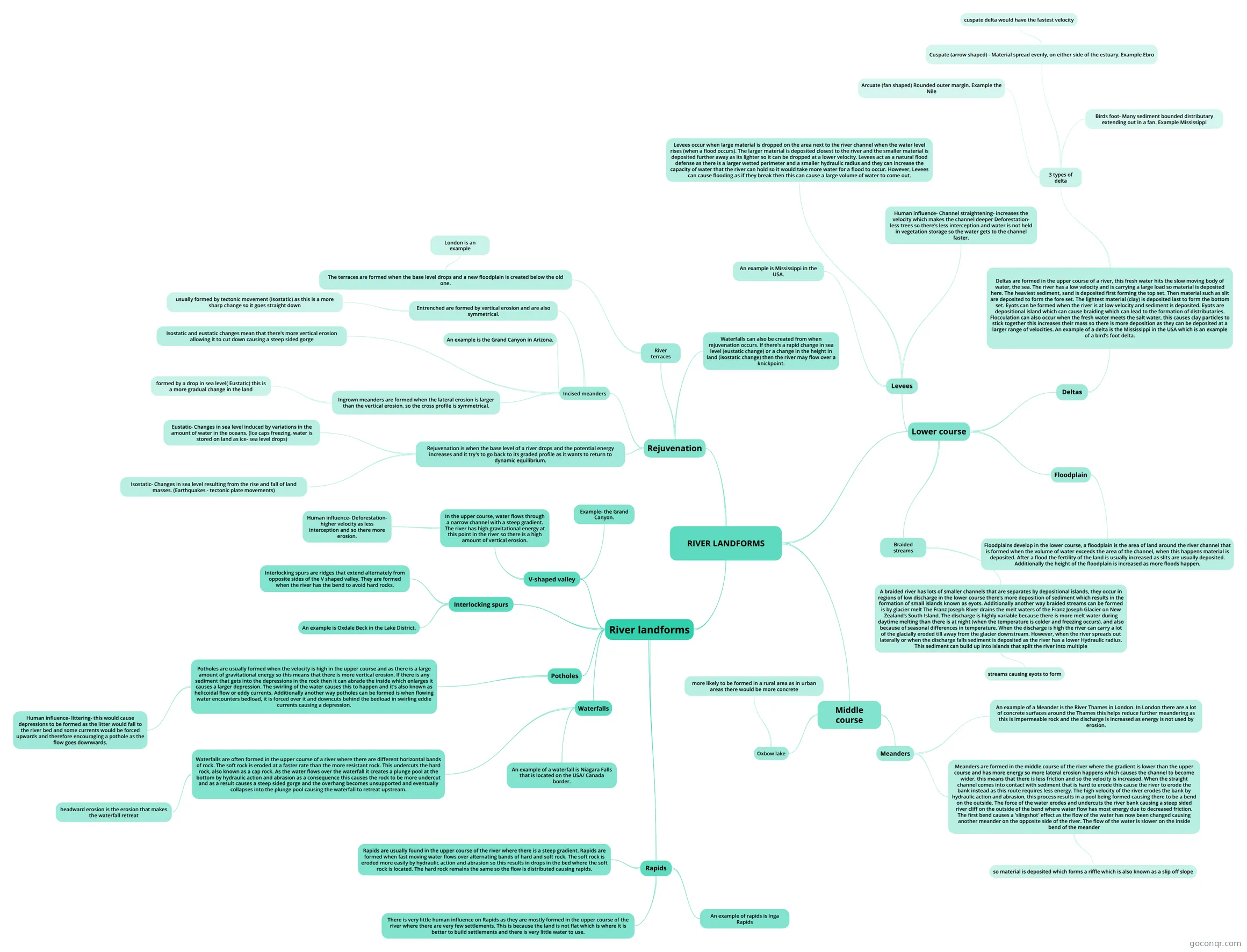
Mind map: River landforms
Inhalt der Mindmap
River landforms
V-shaped valley
- In the upper course, water flows through a narrow channel with a steep gradient. The river has high gravitational energy at this point in the river so there is a high amount of vertical erosion.
- Human influence- Deforestation- higher velocity as less interception and so there more erosion.
- Example- the Grand Canyon.
- In the upper course, water flows through a narrow channel with a steep gradient. The river has high gravitational energy at this point in the river so there is a high amount of vertical erosion.
Interlocking spurs
- Interlocking spurs are ridges that extend alternately from opposite sides of the V shaped valley. They are formed when the river has the bend to avoid hard rocks.
- An example is Oxdale Beck in the Lake District.
Potholes
- Potholes are usually formed when the velocity is high in the upper course and as there is a large amount of gravitational energy so this means that there is more vertical erosion. If there is any sediment that gets into the depressions in the rock then it can abrade the inside which enlarges it causes a larger depression. The swirling of the water causes this to happen and it's also known as helicoidal flow or eddy currents. Additionally another way potholes can be formed is when flowing water encounters bedload, it is forced over it and downcuts behind the bedload in swirling eddie currents causing a depression.
- Human influence- littering- this would cause depressions to be formed as the litter would fall to the river bed and some currents would be forced upwards and therefore encouraging a pothole as the flow goes downwards.
- Potholes are usually formed when the velocity is high in the upper course and as there is a large amount of gravitational energy so this means that there is more vertical erosion. If there is any sediment that gets into the depressions in the rock then it can abrade the inside which enlarges it causes a larger depression. The swirling of the water causes this to happen and it's also known as helicoidal flow or eddy currents. Additionally another way potholes can be formed is when flowing water encounters bedload, it is forced over it and downcuts behind the bedload in swirling eddie currents causing a depression.
Waterfalls
- Waterfalls are often formed in the upper course of a river where there are different horizontal bands of rock. The soft rock is eroded at a faster rate than the more resistant rock. This undercuts the hard rock, also known as a cap rock. As the water flows over the waterfall it creates a plunge pool at the bottom by hydraulic action and abrasion as a consequence this causes the rock to be more undercut and as a result causes a steep sided gorge and the overhang becomes unsupported and eventually collapses into the plunge pool causing the waterfall to retreat upstream.
- headward erosion is the erosion that makes the waterfall retreat
- An example of a waterfall is Niagara Falls that is located on the USA/ Canada border.
- Waterfalls are often formed in the upper course of a river where there are different horizontal bands of rock. The soft rock is eroded at a faster rate than the more resistant rock. This undercuts the hard rock, also known as a cap rock. As the water flows over the waterfall it creates a plunge pool at the bottom by hydraulic action and abrasion as a consequence this causes the rock to be more undercut and as a result causes a steep sided gorge and the overhang becomes unsupported and eventually collapses into the plunge pool causing the waterfall to retreat upstream.
Rapids
- Rapids are usually found in the upper course of the river where there is a steep gradient. Rapids are formed when fast moving water flows over alternating bands of hard and soft rock. The soft rock is eroded more easily by hydraulic action and abrasion so this results in drops in the bed where the soft rock is located. The hard rock remains the same so the flow is distributed causing rapids.
- An example of rapids is Inga Rapids
- There is very little human influence on Rapids as they are mostly formed in the upper course of the river where there are very few settlements. This is because the land is not flat which is where it is better to build settlements and there is very little water to use.
RIVER LANDFORMS
- Middle course
- Meanders
- Meanders are formed in the middle course of the river where the gradient is lower than the upper course and has more energy so more lateral erosion happens which causes the channel to become wider, this means that there is less friction and so the velocity is increased. When the straight channel comes into contact with sediment that is hard to erode this cause the river to erode the bank instead as this route requires less energy. The high velocity of the river erodes the bank by hydraulic action and abrasion, this process results in a pool being formed causing there to be a bend on the outside. The force of the water erodes and undercuts the river bank causing a steep sided river cliff on the outside of the bend where water flow has most energy due to decreased friction. The first bend causes a 'slingshot' effect as the flow of the water has now been changed causing another meander on the opposite side of the river. The flow of the water is slower on the inside bend of the meander
- so material is deposited which forms a riffle which is also known as a slip off slope
- An example of a Meander is the River Thames in London. In London there are a lot of concrete surfaces around the Thames this helps reduce further meandering as this is impermeable rock and the discharge is increased as energy is not used by erosion.
- Meanders are formed in the middle course of the river where the gradient is lower than the upper course and has more energy so more lateral erosion happens which causes the channel to become wider, this means that there is less friction and so the velocity is increased. When the straight channel comes into contact with sediment that is hard to erode this cause the river to erode the bank instead as this route requires less energy. The high velocity of the river erodes the bank by hydraulic action and abrasion, this process results in a pool being formed causing there to be a bend on the outside. The force of the water erodes and undercuts the river bank causing a steep sided river cliff on the outside of the bend where water flow has most energy due to decreased friction. The first bend causes a 'slingshot' effect as the flow of the water has now been changed causing another meander on the opposite side of the river. The flow of the water is slower on the inside bend of the meander
- Oxbow lake
- more likely to be formed in a rural area as in urban areas there would be more concrete
- Meanders
- Lower course
- Floodplain
- Floodplains develop in the lower course, a floodplain is the area of land around the river channel that is formed when the volume of water exceeds the area of the channel, when this happens material is deposited. After a flood the fertility of the land is usually increased as slits are usually deposited. Additionally the height of the floodplain is increased as more floods happen.
- Levees
- Levees occur when large material is dropped on the area next to the river channel when the water level rises (when a flood occurs). The larger material is deposited closest to the river and the smaller material is deposited further away as its lighter so it can be dropped at a lower velocity. Levees act as a natural flood defense as there is a larger wetted perimeter and a smaller hydraulic radius and they can increase the capacity of water that the river can hold so it would take more water for a flood to occur. However, Levees can cause flooding as if they break then this can cause a large volume of water to come out.
- An example is Mississippi in the USA.
- Human influence- Channel straightening- increases the velocity which makes the channel deeper Deforestation- less trees so there's less interception and water is not held in vegetation storage so the water gets to the channel faster.
- Deltas
- Deltas are formed in the upper course of a river, this fresh water hits the slow moving body of water, the sea. The river has a low velocity and is carrying a large load so material is deposited here. The heaviest sediment, sand is deposited first forming the top set. Then material such as slit are deposited to form the fore set. The lightest material (clay) is deposited last to form the bottom set. Eyots can be formed when the river is at low velocity and sediment is deposited. Eyots are depositional island which can cause braiding which can lead to the formation of distributaries. Flocculation can also occur when the fresh water meets the salt water, this causes clay particles to stick together this increases their mass so there is more deposition as they can be deposited at a larger range of velocities. An example of a delta is the Mississippi in the USA which is an example of a bird's foot delta.
- 3 types of delta
- Arcuate (fan shaped) Rounded outer margin. Example the Nile
- Cuspate (arrow shaped) - Material spread evenly, on either side of the estuary. Example Ebro
- cuspate delta would have the fastest velocity
- Birds foot- Many sediment bounded distributary extending out in a fan. Example Mississippi
- 3 types of delta
- Deltas are formed in the upper course of a river, this fresh water hits the slow moving body of water, the sea. The river has a low velocity and is carrying a large load so material is deposited here. The heaviest sediment, sand is deposited first forming the top set. Then material such as slit are deposited to form the fore set. The lightest material (clay) is deposited last to form the bottom set. Eyots can be formed when the river is at low velocity and sediment is deposited. Eyots are depositional island which can cause braiding which can lead to the formation of distributaries. Flocculation can also occur when the fresh water meets the salt water, this causes clay particles to stick together this increases their mass so there is more deposition as they can be deposited at a larger range of velocities. An example of a delta is the Mississippi in the USA which is an example of a bird's foot delta.
- Braided streams
- A braided river has lots of smaller channels that are separates by depositional islands, they occur in regions of low discharge in the lower course there's more deposition of sediment which results in the formation of small islands known as eyots. Additionally another way braided streams can be formed is by glacier melt The Franz Joseph River drains the melt waters of the Franz Joseph Glacier on New Zealand’s South Island. The discharge is highly variable because there is more melt water during daytime melting than there is at night (when the temperature is colder and freezing occurs), and also because of seasonal differences in temperature. When the discharge is high the river can carry a lot of the glacially eroded till away from the glacier downstream. However, when the river spreads out laterally or when the discharge falls sediment is deposited as the river has a lower Hydraulic radius. This sediment can build up into islands that split the river into multiple
- streams causing eyots to form
- A braided river has lots of smaller channels that are separates by depositional islands, they occur in regions of low discharge in the lower course there's more deposition of sediment which results in the formation of small islands known as eyots. Additionally another way braided streams can be formed is by glacier melt The Franz Joseph River drains the melt waters of the Franz Joseph Glacier on New Zealand’s South Island. The discharge is highly variable because there is more melt water during daytime melting than there is at night (when the temperature is colder and freezing occurs), and also because of seasonal differences in temperature. When the discharge is high the river can carry a lot of the glacially eroded till away from the glacier downstream. However, when the river spreads out laterally or when the discharge falls sediment is deposited as the river has a lower Hydraulic radius. This sediment can build up into islands that split the river into multiple
- Floodplain
- Rejuvenation
- Rejuvenation is when the base level of a river drops and the potential energy increases and it try's to go back to its graded profile as it wants to return to dynamic equilibrium.
- Isostatic- Changes in sea level resulting from the rise and fall of land masses. (Earthquakes - tectonic plate movements)
- Eustatic- Changes in sea level induced by variations in the amount of water in the oceans. (Ice caps freezing, water is stored on land as ice- sea level drops)
- Incised meanders
- Ingrown meanders are formed when the lateral erosion is larger than the vertical erosion, so the cross profile is symmetrical.
- formed by a drop in sea level( Eustatic) this is a more gradual change in the land
- Entrenched are formed by vertical erosion and are also symmetrical.
- usually formed by tectonic movement (Isostatic) as this is a more sharp change so it goes straight down
- Isostatic and eustatic changes mean that there's more vertical erosion allowing it to cut down causing a steep sided gorge
- An example is the Grand Canyon in Arizona.
- Ingrown meanders are formed when the lateral erosion is larger than the vertical erosion, so the cross profile is symmetrical.
- River terraces
- The terraces are formed when the base level drops and a new floodplain is created below the old one.
- London is an example
- The terraces are formed when the base level drops and a new floodplain is created below the old one.
- Waterfalls can also be created from when rejuvenation occurs. If there's a rapid change in sea level (eustatic change) or a change in the height in land (isostatic change) then the river may flow over a knickpoint.
- Rejuvenation is when the base level of a river drops and the potential energy increases and it try's to go back to its graded profile as it wants to return to dynamic equilibrium.
- Middle course
Informationen
- Beschreibung
- AS - Level Geography (Rivers) Mindmap am River landforms, erstellt von lisa.groom am 05/05/2016.
- Erstellt von
- lisa.groom
- Aufrufe
- 1
- Bewertung