
Mindmap
TECTONIC HAZARDS AND PROCESSES
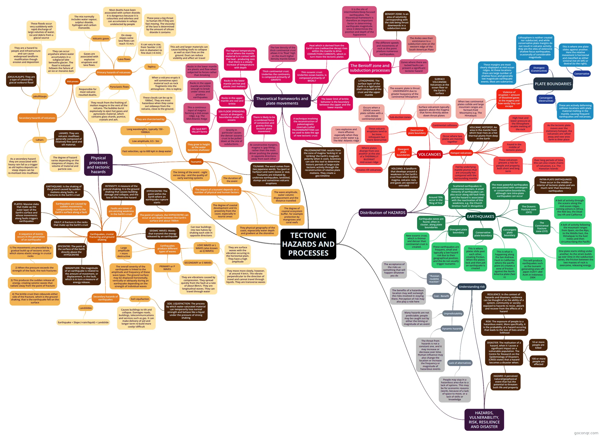
Mind map: Tectonic hazards and processes
Inhalt der Mindmap
TECTONIC HAZARDS AND PROCESSES
Distribution of HAZARDS
- VOLCANOES
- Violence of eruption = amount of dissolved gases in the magma and how easily they can escape
- Destructive plate boundary
- Occur where two plates are moving together
- Sub-duction zones
- Occurs when a DENSE oceanic plate collides with a LESS-DENSE continental plate
- The oceanic plate is thrust UNDERNEATH due to greater buoyancy of the continental lithosphere
- LITHOSPHERE: The surface layer of the Earth is a rigid outer shell composed of the crust and the upper mantle
- Surface volcanism typically appears above the magma that forms directly above down thrust plates
- SURFACE VOLCANISM: Volcanoes at the ocean floor or the Earth's surface
- Continental collisions
- When two continental plates collide and large mountain ranges are formed (Fold Mountains) e.g. The Himalayas
- These volcanic eruptions tend to be more infrequent but more destructive
- Divergent plate boundaries
- Creates rift volcanoes
- Less explosive and more effusive; especially when they occur under water e.g. The Mid -Atlantic ridge
- Where plates diverge from one another at the site of a THERMALLY BUOYANT mid-ocean ridge
- Creates rift volcanoes
- Hotspot volcanoes
- Found in the middle of tectonic plates
- Fed by underlying mantle plumes that are unusually hot compared with the surrounding mantle
- These volcanoes present a risk for people and property, both short and long term
- VOLCANIC HOTSPOT: An area in the mantle from which heat rises as a hot thermal plume from deep in the Earth
- High heat and lower pressure at the lithosphere enable melting of the rock
- As the tectonic plate moves over the stationary hotspot, the volcanoes are rafted away and new ones form in thier place
- Over long periods of time this can also create chains of volcanoes, e.e. The Hawaiian Islands
- VOLCANO: A landform that develops around a weakness in the Earth's crust from which molten magma, volcanic rock, and gases are ejected or extruded
- EARTHQUAKES
- Earthquake zones are found, often in cluster, along plate boundaries
- Around 70% occur in the 'Ring of Fire'
- The most powerful earthquakes are associated with convergent or conservative boundaries, although rare intra-plate earthquakes can occur
- INTRA-PLATE EARTHQUAKES: These occur in the middle or interior of tectonic plates and are much rarer than boundary earthquakes
- The Oceanic fracture zone (OFZ)
- A belt of activity through the oceans along the mid-ocean ridges, coming ashore in Africa, the Red Sea, the Dead Sea rift and California
- The Continental fracture zone (CFZ)
- A belt of activity following the mountain ranges from Spain, via the Alps, to the Middle East, the Himalayas to the East Indies and then circumscribing the Pacific
- Scattered earthquakes in continental interiors. A small minority of earthquakes can also occur along old fault lines and the hazard is associated with the reactivation of this weakness, e.g. the Church Stretton Fault in Shropshire
- Divergent plate boundary
- New oceanic crust, which is thinner and denser than continental crust is created.
- These earthquakes are frequent, small and typically a low hazard risk due to their geographical position, and the do not usually trigger tsunamis
- Conservative plate boundary
- This is where plates slide past each other, creating friction. When the plates lock and then jolt an earthquake is created
- This is what is happening along the San Andreas Fault in California where the pacific plate (n) creates a zone of friction against the North America plate (fast n)
- Convergent plate boundary
- One plate starts sliding under another; As the strain builds up over time in the subduction zones, the friction between the two masses of rock is overcome, releasing energy.
- This will produce earthquakes such as the tsunami generating ones off Japan in2011 abd Aceh in Indonesia 2004
- PLATE BOUNDARIES
- Divergent (Constructive)
- These margins are most clearly displayed at mid-ocean ridges. At these locations there are large number of shallow focus and generally low magnitude earthquake events. Most are submarine.
- Convergent (Destructive)
- These are actively deforming collision locations with plate material melting in the mantle, causing frequent earthquakes and volcanoes.
- Conservative
- This is where one plate slides against another. Here the relative movement is horizontal and classified as either sinistral (tot eh left) or dextral (to the right).
- Lithosphere is neither created nor subducted, and while conservative plate margins do not result in volcanic activity, they are the sites of extensive shallow focus earthquakes, ocasionally of considerable magnitude.
- Divergent (Constructive)
- VOLCANOES
Theoretical frameworks and plate movements
- Thin oceanic crust: Underlies ocean basins, is composed primarily of BASALT
- Thick continental crust: Underlies the continents, is composed primarily of GRANITE
- The low density of the thick continental crust allows it to 'float' high on the much higher density mantle below
- The highest temperatures occur where the mantle material is in contact with the heat - producing core that there is a steady increase of temperature with depth
- Rocks in the upper mantle are cool and brittle
- Rocks in the upper mantle are brittle enough to break under stress and produce earthquakes
- Rocks in the lower mantle are hot and plastic (not molten)
- Rocks in the lower mantle are plastic and flow when subjected to forces rather than breaking
- The lower limit of brittle behavior is the boundary between the upper and the lower mantle
- Heat which is derived from the Earth's core (radioactive decay) rises within the mantle to drive CONVECTION CURRENTS, which in turn move the tectonic plates
- SEA FLOOR SPREADING occurs at divergent boundaries under the oceans
- This a continous input of magma forming a mid-ocean ridge, e.g. The Mid-Atlantic Ridge
- On land RIFT VALLEY forms
- A technique involving the reconstruction of paleomagnetic reversals (called PALEOMAGNETISM) can be used to date the age of new tectonic crust
- PALEOMAGNETISM: results from the zone of magma 'locking in' or 'striking' the Earth's magnetic polarity when it cools. Scientists can use this tool to determine historic periods of large-scale tectonic activity through the reconstruction of relative plate motions. They create a geo-timeline
- There is likely to be a combined force of convection and gravity driving tectonic plate movement
- Gravity in particular causes the denser oceanic crust to be pulled down at the site of subductions.
- At constructive margins, magma is 'gap filling', rather than the main driver pushing the plates in opposite directions away from each other
- The Benioff zone and subduction processes
- The different speeds and movements of rock at this point produce numerous earthquakes.
- BENIOFF ZONE: Is an area of seismicity corresponding with the slab being thrust downwards in a subduction zone
- It is the site of intermediate/deep-focused earthquakes. The theoretical framework is therefore an important factor in determining earthquake magnitude, since it determines the position and depth of the hypocentre
- Zones where there are locked faults can present a significant tectonic hazard
- The Andes owe their exististance to a subduction zone on the western edge of the South American Plate
Physical processes and tectonic hazards
- Earthquakes, crustal fracturing and ground shaking
- Earthquakes are caused by sudden movements comparatively near to the Earth's surface along a fault
- Faults are zones of pre-existing weakness in the Earth's crust
- A sequence of events occurs in the generation of an earthquake
- 1) The movements are preceded by a gradual build up of tectonic strain, which stores elastic energy in crustal rocks
- 2) When the pressure exceeds the strength of the fault, the rock fractures
- 3) This produces the sudden release of energy, creating seismic waves that radiate away from the point of fracture
- 4) The brittle crust then rebounds either side of the fracture, which is the ground shaking, that is the earthquake felt on the surface
- 3) This produces the sudden release of energy, creating seismic waves that radiate away from the point of fracture
- 2) When the pressure exceeds the strength of the fault, the rock fractures
- 1) The movements are preceded by a gradual build up of tectonic strain, which stores elastic energy in crustal rocks
- The point of rupture, the HYPOCENTRE can occur at ant depth between the Earth's surface and about 700km
- HYPOCENTRE: The point within the Earth where an earthquake rupture starts
- EARTHQUAKE: Is the shaking of the ground caused by sudden motions along faults, or fractures in the Earth's crust
- FAULT: A fracture in the rocks that make up the Earth's crust
- EPICENTRE: The point at the surface of the Earth directly above the HYPOCENTRE
- PLATES: Massive slabs that make up the outer layer of the Earth's surface and whose movements along faults triggers earthquakes
- SEISMIC WAVES: Waves that transmit the energy released by an earthquake
- Earthquakes produce different types of waves
- PRIMARY or P WAVES
- They are vibrations caused by compression. They spread quickly from the fault at a rate of about 8km/s. They are longitudinal waves. They can travel through water
- SECONDARY or S WAVES
- They move more slowly, however, at around 4 km/s. The vibrate perpendicular to the direction of travel and cannot travel through liquids. They are transverse waves
- LOVE WAVES or L WAVES (also known as Q WAVES)
- They are surface waves with the vibration occuring in the horizontal plain. They have a high amplitude
- Can tear buildings into two halves by shaking each side in opposite directions
- Large amplitude = more destructive
- The overall severity of the earthquake is linked to the amplitude and frequency of these wave types. The ground surface may be displaced horizontally, vertically or obliquely during an earthquake depending on the strength of individual waves
- PRIMARY or P WAVES
- Secondary hazards of earthquakes
- Soil Liquifaction
- SOIL LIQUEFACTION: The process by which water-saturated material can temporarily lose normal strength and behave like a liquid under the pressure of strong shaking
- Causes buildings to tilt and collapse. Damages roads, buildings, telecommunications and services such as gas. It can make delivery of aid and longer term re-build more costly/ difficult
- Landslides
- Earthquake + Slope (+rain/liquid) = Landslide
- Soil Liquifaction
- INTENSITY: A measure of the ground shaking. It is the ground shaking that causes building damage and collapse, and the loss of life from the hazard
- MAGNITUDE: The magnitude of an earthquake is related to the amount of movement, or displacement, in the fault, which is in turn a measure of energy release.
- Tsunamis
- They are charcterised by:
- Long wavelengths, typically 150 - 1000km
- Low amplitude, 0.5 - 5m
- Fast velocities, up to 600 kph in deep water
- Low amplitude, 0.5 - 5m
- Long wavelengths, typically 150 - 1000km
- TSUNAMI: The word comes from two Japanese words; Tsu (port or harbour) and nami (wave or sea). Tsunamis are initiated by undersea earthquakes, landslied, slumps and sometimes volcanic eruptions
- They grow in height as the water becomes shallower
- The impact of a tsunami depends on a number of physical and human factors:
- The duration of the event
- The wave amplitude, water column displacement and the distance travelled
- They physical geography of the coast, espeacially water depth and gradient at the shoreline
- The degree of coastal ecosystem buffer, for example protection by mangroves and coral reefs
- The timing of the event - night versus day - and the quality of early warning systems
- The degree of coastal development and its proximity from the coast, especially in tourist areas
- They are charcterised by:
- Volcanoes
- Primary hazards of volcanoes
- Pyroclastic flows
- Responsible for most volcanic resulted deaths.
- They result from the frothing of molten magma in the vent of the volcano. The bubbles burst explosively to eject hot gases and pyroclastic material, which contains glass shards, pumice, crystals and ash.
- These clouds can be up to 1000oC. They are most hazardous when they come out sideways from the volcano, close to the ground.
- Tephra
- When a volcano erupts it will sometimes eject material such as rock fragments into the atmosphere - this is tephra
- It can vary in size, from 'bombs' (>32 mm in diameter) to fine dust (<4 mm)
- This ash and larger materials can cause building roofs to collapse as well as start fires on the ground. Dust can reduce visibility and affect air travel
- Lava flows
- These pose a big threat to human life if they are fast moving. The viscosity of the lava is determined by the amount of silicon dioxide it contains
- On steep slopes some lava flows can reach 15 m/s
- Volcanic gases
- Gases are associated with explosive eruptions and lava flows.
- The mix normally includes water vapour, sulphur dioxide, hydrogen and carbon monoxide.
- Most deaths have been associated with carbon dioxide; it is dangerous because it is colourless and odorless and can accumulate in valleys undetected by people
- Pyroclastic flows
- Secondary hazards of volcanoes
- Lahars
- LAHARS: They are volcanic mudflows generally composed of relatively fine sand and silt material.
- The degree of hazard varies depending on the steepness of slopes, the volume of material and particle size.
- As a secondary hazard they are associated with heavy rain fall as a trigger as old tephra deposits on steep slopes can be re-moilised into mudflows
- Jokulhlaups
- JOKULHLAUPS: They are a type of catastrphic glacial outburst flood
- They are a hazard to people and infrastructure and can cause widespread landform modification though erosion and deposition
- These floods occur very sudddenly with rapid discharge of large volumes of water, ice and debris from a glacial source
- They can occur anywhere where water accumulates in a subglacial lake beneatha glacier. The flood is initiated followin the failure of an ice or moraine dam
- Lahars
- Primary hazards of volcanoes
- Earthquakes, crustal fracturing and ground shaking
HAZARDS, VULNERABILITY, RISK, RESILIENCE AND DISASTER
- Understanding risk
- Unpredictability
- Many hazards are not predictable; people may be caught out by either the timing or magnitude of an event
- Lack of alternatives
- People may stay in a hazardous area due to a lack of options. This may be for economic reasons (work), because of a lack of space to move, or a lack of skills or knowledge
- Dynamic hazards
- The threat from hazards is not a constant one, and it may increase or decrease over time. Human influence may also change the location or increase the frequency or magnitude of hazardous events
- Cost - Benefit
- The benefits of a hazardous location may well outweigh the risks involved in staying there. Perception of risk may also play a role here
- ''Russian roulette reaction''
- The acceptance of the risks as something that will happen whatever you do
- Unpredictability
- HAZARD: A perceived natural/geophysical event that has the potential to threaten both life and property
- DISASTER: The realisation of a hazard, when it 'causes a significant impact on a vulnerable population. The Centre for Research on the Epidemiology of Disasters (CRED) states that a hazard becomes a disaster when:
- 10 or more people are killed
- 100 or more people are affected
- RISK: The exposure of people to a hazardous event. More specifically, it is the probability of a hazard occuring that leads to the loss of lives and/or livlihood
- RESILIENCE: In the context of hazards and disasters, resilience can be thought of as the ability of a system, community or society exposed to hazards to resist, absorb and recover from the effects of a hazard
- DISASTER: The realisation of a hazard, when it 'causes a significant impact on a vulnerable population. The Centre for Research on the Epidemiology of Disasters (CRED) states that a hazard becomes a disaster when:
- Understanding risk
Informationen
- Beschreibung
- A level Geography Mindmap am TECTONIC HAZARDS AND PROCESSES, erstellt von Anjali Dhunna am 27/01/2017.
- Erstellt von
- Anjali Dhunna
- Aufrufe
- 3
- Bewertung