
Mindmap
Major Climate Controls
Inhalt der Mindmap
Major Climate Controls
The structure of the atmosphere
- Atmosphere: The gaseous envelope that surrounds a planet ie. Earth. Retained by gravitational attraction and largely rotates with it.
- Made up of 78% Nitrogen, 21% Oxygen and <1% Trace elements
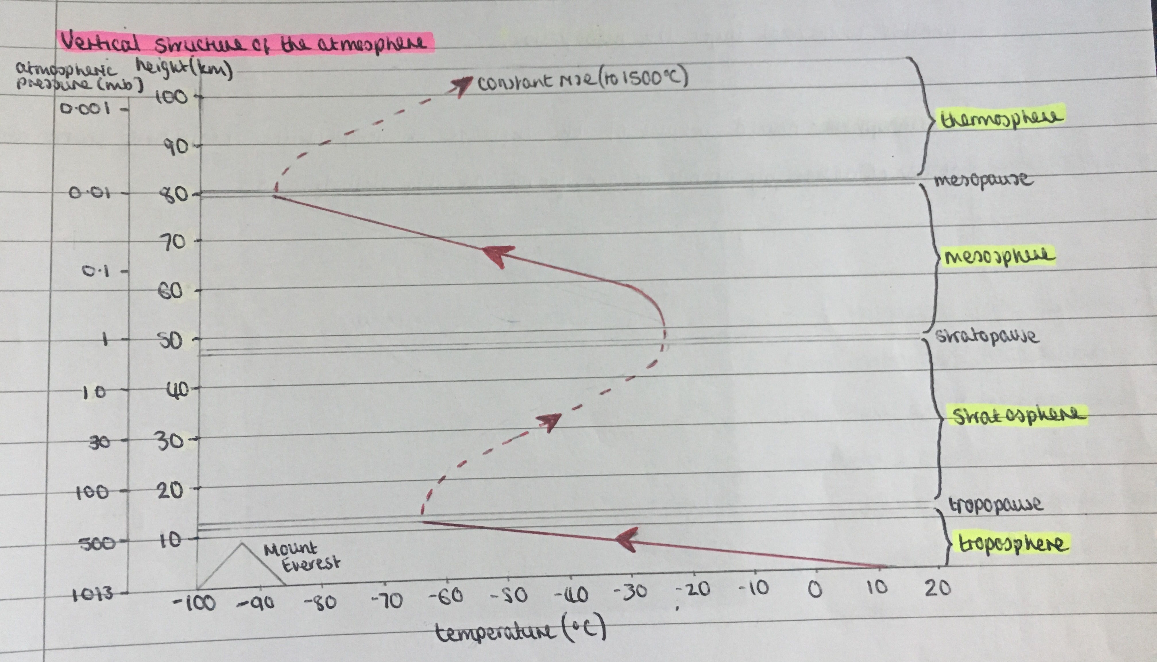
- Vertical structure of the atmosphere
- Troposphere: From Earth's surface up to 12km. Temperature decrease with altitude (Earth's surface heats lower altitudes). Lots of turbulence - warm air rises, cool air sinks. Lots of clouds - water vapour evaporates from Earth's surface.
- Tropopause: Boundary between troposphere and stratosphere. Temperature remains constant. Jet streams found just below.
- Stratosphere: From 12km to 50km up. Temperature increase with altiitude - Ozone layer found in lower stratosphere (absorbs UV radiation - heats upper stratosphere). No turbulence. No clouds
- Stratopause: Boundary between stratosphere and mesosphere.
- Mesosphere: From 50km - 85-90km up. Temperature decrease with altitude (stratosphere heats lower altitudes). No water vapour/dust to absorb radiation (reaches temps of -90oC).
- Mesopause: Boundary between mesosphere and thermosphere.
- Thermosphere: From 90km - 100km up. Temperature increase with altitude - small amounts of oxygen found here (absorbs UV radiation - heats thermosphere).
- Troposphere: From Earth's surface up to 12km. Temperature decrease with altitude (Earth's surface heats lower altitudes). Lots of turbulence - warm air rises, cool air sinks. Lots of clouds - water vapour evaporates from Earth's surface.
- Atmosphere: The gaseous envelope that surrounds a planet ie. Earth. Retained by gravitational attraction and largely rotates with it.
Global heat budget
- Atmospheric heat budget
- Only 52% of the short wave solar radiation (insolation) is absorbed by the Earth's surface. This is released as long wave radiation i.e. heat energy. The rest is absorbed by clouds, water vapour, dust and gases or reflected (long wave radiation) back into the Earth's atmosphere
- Atmospheric heat budget: The balance between incoming and outgoing solar radiation (heat energy) from the planet.
- Insolation: Energy from the sun in the form of shortwave solar radiation.
- Albedo: the amount of solar radiation reflected by a surface (measure of reflectivity of a surface)
- Latitude and energy balance
- There is a net gain in solar energy in the tropics and a net deficit near the poles. A surplus of energy occurs when there is more insolation than outgoing radiation (between 35° north and 35° south). A deficit occurs when radiation exceeds insolation (between 35° north and the north pole and 35° south and the south pole).
- Horizontal heat transfer: Heat is transferred away from the tropics in order to prevent the Equator becoming increasingly hotter and the poles colder. Winds are 80% responsible for this(atmospheric circulation) , oceans are 20% responsible.
- Vertical heat transfer: To stop the Earth's surface getting too hot and the atmosphere colder vertical heat transfer takes place. Usually through radiation, conduction, convection and latent heat transfer.
- Factors affecting insolation
- Long term factors - Altitude of the land (Air pressure decreases with increased altitude, molecules which receive/retain heat become wider and fewer, create less heat so lower temperatures). Altitude of the sun (Higher angle of the sun in the sky (poles) means the insolation is spread over a larger surface area so less solar radiation per m², also more likely for insolation to be absorbed or reflected). Land and sea (Sea has a greater heat capacity so requires twice as much energy as land to heat so in summer the land heats up quicker but the sea retains heat for longer, also cools less rapidly in winter so coastal regions have smaller temperature ranges than inland areas).
- Prevailing winds (The temperature of an air mass is determined by the area it originated from and where it travels across, winds blowing from the sea tend to be cooler in the summer and warmer in the winter than those coming over land).Ocean currents (Warm currents move polewards (away from the equator) and cooler currents replace them by moving towards the equator (gyre), this warms or cools the air temperature of coastal areas (warm currents increase temperature of cooler coastal land in winter, cooler currents decrease temperature of warmer coastal land in summer).
- Short term factors - Seasonal change (When the sun is overhead at the Equator (equinox) in spring and autumn insolation is distributed evenly between the two hemispheres, at the summer and winter soltices the sun is directly overhead the tropics so the hemisphere experiencing summer will receive the most insolation). Length of day and night (In polar regions, when the sun is tilted away, there are fewer hours of daylight hours therefore less insolation compared to those at lower latitudes with more hours of daylight so more insolation).
- Local factors - Cloud cover (Clouds can absorb, reflect or scatter insolation but also can keep heat in the lower atmosphere, if there's a clear day temperatures rise more rapidly as more insolation can reach the Earth's surface (which clouds would usually absorb) likewise if there's a clear night the insolation isn't kept in by the clouds therefore the temperature can fall quicker. Urbanisation (Urban surfaces tend to absorb more heat (less albedo) during the day and radiate more at night than natural surfaces resulting in urban heat island effects).
- Long term factors - Altitude of the land (Air pressure decreases with increased altitude, molecules which receive/retain heat become wider and fewer, create less heat so lower temperatures). Altitude of the sun (Higher angle of the sun in the sky (poles) means the insolation is spread over a larger surface area so less solar radiation per m², also more likely for insolation to be absorbed or reflected). Land and sea (Sea has a greater heat capacity so requires twice as much energy as land to heat so in summer the land heats up quicker but the sea retains heat for longer, also cools less rapidly in winter so coastal regions have smaller temperature ranges than inland areas).
- Atmospheric heat budget
Atmospheric circulation
- Winds are large scale movements of air caused by the difference in air pressure (blow from high pressure -> low pressure). Warm rising air creates areas of low pressure, a body of cool falling air creates areas of high pressure.
- ITCZ (Inter-tropical convergence zone) : Low pressure zone located at the Equator between both Hadley cells. The sun warms the Earth causing air to rise, resulting in convection currents. Rising air creates low pressure, heavy rainfall and clouds can be created due to the rising water vapour condensing (thunderstorms likely). In the summer (June) - sun is located above the tropic of Cancer so pulls the ITCZ north of the equator. In the winter (December) - the sun is over the tropic of Capricorn so pulls the ITCZ south of the equator.
- Global Atmospheric circulation cells
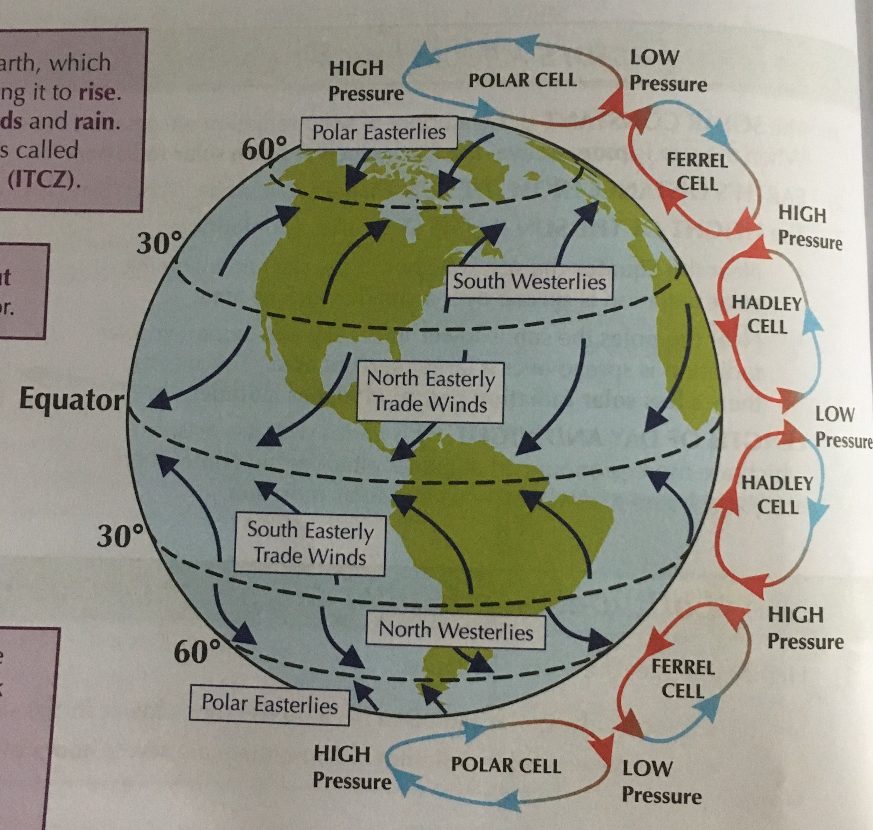
- The Hadley cell - The sun heats the Earth at the equator which causes the air to rise. This creates the low pressure zone known as the ITCZ. As the air rises it begins to cool and moves 30° North and 30° South of the Equator. 30° North and South of the equator the cooler air sinks creating high pressure and clear skies, known as subtropical anticyclones. At ground level some of the air returns to the Equator as trade winds.
- Trade winds: A wind blowing steadily to the Equator, they blow to the right in the northern hemishpere and to the left in the southern hemisphere (due to the deflection by the Coriolis force)
- Ferrel cell - The air that doesn't return as trade winds becomes part of the Ferrel cell. The warm surface winds (area of high pressure) blow towards the poles (area of low pressure) until they reach 60° north and south of the Equator. Here the warmer air meets the denser cooler air of the poles so rises creating low pressure. This area of unstable air is associated with depressions and heavy rainfall. Some of the air continues in the ferrel cell and moves back towards the equator, and the rest joins the polar cell.
- Polar cell - When the ferrel and the polar cells meet, the warm air rises and as it begins to cool moves north and southwards towards the poles. Here the cool air sinks creating high pressure. The high pressure air is blown back towards the Equator (low pressure) in surface winds.
- The Westerlies: Named as they blow from the west to east, the westerlies are found in the mid latitudes between 30° and 60°. Due to the Coriolis force they become the south westerlies in the northern hemisphere and the north westerlies in the southern hemisphere. (In the southern hemisphere there is more ocean than land so blow with much greater force then in the northern hemisphere).
- Polar easterlies: Blow from the polar high pressure belts towards the temperate high pressure belts. These polar winds meet with the warm easterlies at 60° north and south.
- The Hadley cell - The sun heats the Earth at the equator which causes the air to rise. This creates the low pressure zone known as the ITCZ. As the air rises it begins to cool and moves 30° North and 30° South of the Equator. 30° North and South of the equator the cooler air sinks creating high pressure and clear skies, known as subtropical anticyclones. At ground level some of the air returns to the Equator as trade winds.
Ocean currents
- Ocean currents are large scale movements of water cause by differences in water density. The density depends on the water's temperature and salinity. Ocean currents are a form of horizontal heat transfer - warm water is transferred from the tropics polewards which raises air temperatures of the maritime environments, warming the coastal regions nearby. Cool water, from the poles, replaces the warm water. This lowers the air temperature and cools coastal areas nearby.
- Warm water has a lower density and rises whereas cold water has a higher density. Also, the water's density increases with a higher salt content.
- Gyre: Large system of circulating ocean currents formed by global wind patterns and the Coriolis force. They travel clockwise in the Northern hemisphere and anti-clockwise in the southern hemisphere.
- Ocean currents are affected by the surface winds, the position of the land masses and other currents
- The ocean conveyor belt - At the equator the heat is very strong resulting in a lot of evaporation and therefore warm, less salty surface water - the Gulf stream begins here. The south east trade winds drives this warm surface water to the northwest into the Gulf of Mexico. The Coriolis force and the west winds then direct the Gulf stream towards Europe and split it up (one part flows south, another east to the Canary Current) and a third part flows north where it releases a lot of heat into the atmosphere (North Atlantic Current). Due to this the water becomes cooler and it's salt content and density rise, causing it to sink to the bottom of the ocean (300m to deep water level). As more water is transported north, the cooler water sinks and moves south to make room for the incoming warm water. The cold bottom water flows south of the equator all the way down to Antartica. Eventually the cold bottom water returns to the surface through mixing of warm, less dense water in the Pacific.
- The Gulf stream carries warm water from the Caribbean Sea along the east coast of America and across the Atlantic to Western Europe. This is hugely important as the warm ocean waters warm Western Europe well beyond what it should given it's latitude. Also, in the northern hemisphere the Gulf stream cools and becomes more dense, some of this water sinks and is carried back to the equator by the Canary Current - this cools the west coast of Africa.
- Ocean currents are large scale movements of water cause by differences in water density. The density depends on the water's temperature and salinity. Ocean currents are a form of horizontal heat transfer - warm water is transferred from the tropics polewards which raises air temperatures of the maritime environments, warming the coastal regions nearby. Cool water, from the poles, replaces the warm water. This lowers the air temperature and cools coastal areas nearby.
Bilder und Dateien der Mindmap
Informationen
- Beschreibung
- A level Geography (Weather & Climate) Mindmap am Major Climate Controls, erstellt von Natalie Bond am 12/05/2017.
- Erstellt von
- Natalie Bond
- Aufrufe
- 5
- Bewertung