
Mindmap
Rivers and Processes
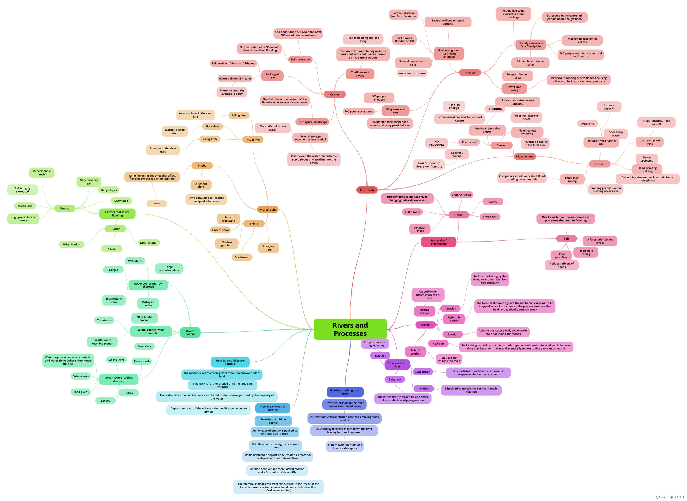
Mind map: Rivers and Processes
Inhalt der Mindmap
Rivers and Processes
Erosion
- Abrasion
- Rock carried along by the river, wear down the river bed and bank
- Hydraulic action
- The force of the river against the banks can cause air to be trapped in cracks or crevices. the process weakens the bank and gradually wears it away
- Solution
- Acids in the water slowly dissolve the river banks and the stones
- Attrition
- Rocks being carried by the river smash together and break into small particles. over time they become smaller and eventually reduce to fine particles called silt
- vertical erosion
- Up and down (increases depth of river)
- Lateral erosion
- Side to side (widens the river)
- Abrasion
Transport in a river
- Suspension
- Tiny particles of sediment are carried in suspension in the rivers current
- Solution
- Dissolved chemicals are carried along in solution
- Saltation
- Smaller stones are picked up and down. this results in a skipping motion
- Traction
- Large stones are dragged along
- Suspension
Rivers course
- Middle course (wider channel)
- Meanders
- Smaller more rounded stones
- Tributaries
- More lateral erosion
- Upper course (narrow channel)
- V-shaped valley
- Interlocking spurs
- Gorges
- Waterfalls
- Large rocks/boulders
- Lower course (Widest channel)
- At sea level
- Water deposition when currents hit and water slows (where river meets the sea)
- Oxbow lakes
- Flood plains
- Levees
- Deltas
- River mouth
- Middle course (wider channel)
How inter-locking spurs form
- 1) vertical erosion in the river creates steep sided valley
- 2) Over time vertical erosion continues making sides weaker
- 3)Gradually material moves down the river leaving hard rock exposed
- 4) Hard rock is left making inter locking spurs
- 3)Gradually material moves down the river leaving hard rock exposed
- 2) Over time vertical erosion continues making sides weaker
- 1) vertical erosion in the river creates steep sided valley
How meanders are formed
- Form in the middle course
- An increase of energy is pushed to one side due to rifles
- This then creates a slight curve over time
- Inside bend has a slip off slope created as material is deposited due to slower flow
- Outside bend we see more lateral erosion and a formation of river cliffs
- The material is deposited from the outside to the inside of the bend is move over to the inner bend due to helicoidal flow (Corkscrew motion)
- Outside bend we see more lateral erosion and a formation of river cliffs
- Inside bend has a slip off slope created as material is deposited due to slower flow
- This then creates a slight curve over time
- An increase of energy is pushed to one side due to rifles
- Form in the middle course
How ox-bow lakes are formed
- The meander keeps eroding until there is a narrow neck of land
- This neck is further eroded until the land cuts through
- The water takes the quickest route so the old route is no longer used by the majority of the water
- Deposition seals off the old meander and it then begins to dry up
- The water takes the quickest route so the old route is no longer used by the majority of the water
- This neck is further eroded until the land cuts through
- The meander keeps eroding until there is a narrow neck of land
Factors that affect flooding
- Human
- Deforestation
- Roads
- Urbanisation
- Physical
- Snow melt
- Steep slopes
- Very hard dry soil
- Impermeable rock
- Marsh land
- Soil is highly saturated
- High precipitation levels
- Human
Hydrographs
- Flashy
- Short lag time
- Time between peak rainfall and peak discharge
- Same factors as the ones that affect flooding produces a short lag time
- <===
- Short lag time
- Shield
- Long lag time
- Shallow gradient
- Lack of snow
- Forest woodland
- Rural areas
- Key terms
- Base flow
- Normal flow of river
- Falling limb
- As water level in the river falls
- Rising limb
- As water in the river rises
- Base flow
- Flashy
Case study
- Causes
- Prolonged rain
- 90mm rain on 15th June
- More than months average in a day
- Followed by 100mm on 25th June
- 90mm rain on 15th June
- Soil saturation
- Soil saturated after 90mm of rain with localised flooding
- Soil hadnt dried out when the next 100mm of rain came down
- Confluence of rivers
- The river Don was already up to its banks but with confluences there is an increase in volume
- Risk of flooding straight away
- The river Don was already up to its banks but with confluences there is an increase in volume
- The physical landscape
- Sheffield lies at the bottom of the Pennies where several rivers meet
- Several storage reservoir collect rainfall
- Overflowed the water ran onto the steep slopes and straight into the rivers
- Normally holds rain water
- Prolonged rain
- Impacts
- Hillsborough and north-west sheffeild
- Several millions to repair damage
- Football stadium had 9m of water in
- 128 homes flooded of 300
- Several severe health risks
- Water borne disease
- Ulley reservoir area
- 700 people evacuated
- 100 people took shelter at a school and army provided food
- 100 people rehoused
- The city centre and Don flood plain
- People had to be evacuated from buidings
- Buses and trains cancelled - people unable to get home
- 900 people trapped in offices
- 200 people stranded at the royal mail centre
- 20 people airlifted to saftey
- Lower Don valley
- Deepest flooded area
- Meadwall shopping centre flooded causing millions to be lost by damaged products
- Industrial centre heavily affected
- Hillsborough and north-west sheffeild
- Management
- Current
- River sheaf
- Concrete channel
- aims to speed up river away from city
- NO FLOODING
- Concrete channel
- Meadwall shopping centre
- Embankment constructed around centre
- Not high enough
- FLOODING
- Embankment constructed around centre
- Flood storage reservoir
- Used for lakes for boats
- Prevented flooding in the local area
- River sheaf
- Future
- Increase river channel size
- Expensive
- Increase capacity
- Speeds up water
- Upstream plant trees
- Trees reduce surface run-off
- Flood proofing building
- Better protected
- By building stronger walls or building on raised land
- Flood plain zoning
- Planning permission for buildings near river
- Companies should relocate if flood proofing is not possible
- Increase river channel size
- Current
- Causes
Hard and soft engineering
- Hard
- Directly aims to manage river changing natural processes
- Dams
- River sheaf
- Channelisation
- Flood walls
- Artificial levees
- Soft
- Works with river to reduce natural processes that lead to flooding
- A forestation (plant trees)
- Flood plain zoning
- Flood prooffing
- Reduces effects of floods
- Hard
Informationen
- Beschreibung
- - Geography (Unit 1: Dynamic Planet) Mindmap am Rivers and Processes, erstellt von Aaronbeaumont am 19/04/2014.
- Erstellt von
- Aaronbeaumont
- Aufrufe
- 19
- Bewertung