
Mindmap
Cold Environments: Glacial Landforms
Inhalt der Mindmap
Cold Environments: Glacial Landforms
Erosional Landforms
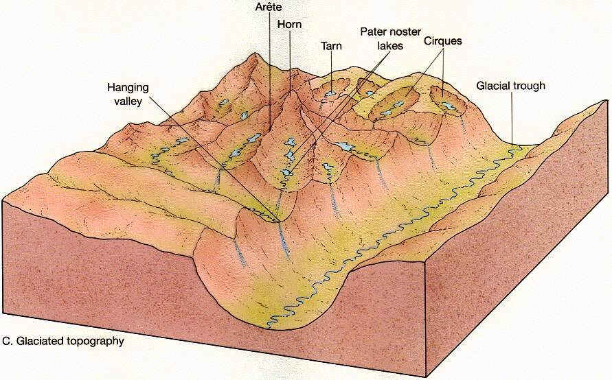
- Corries/Cwm/Cirque
- Corrie is also known as a Cwm (Wales) or a Cirque (France) and is an enlarged hollow on a mountainside.
- Steep back wall and sides, generally hollow and very deep and may contain a small lake called a tarn.
- The front of a corrie often has a raised rock lip, which helps explain the presence of the tarn.
- Arêtes
- Two neighbouring glaciers cut back into a mountainside-each one eroding a corrie-the ridge between the two corries becomes narrower.
- This is a knifed-edged ridge called an arête that are common in both present-day glacial landscapes, and post-glacial landscapes.
- Pyramidal Peak
- When three or more corries erode back-to-back, the ridge then becomes an isolated peak called a pyramidal peak.
- Glacial Trough
- This is, in effect, a U-shaped valley. They tend to be steep-sided and flat-bottomed. They are also generally straight, because of their immense power and inflexibility of the large glaciers that gouge them out
- A valley glacier will just cut through any previously existing interlocking spurs to form truncated spurs up the valley side.
- If a glacier encounters weaker bedrock, or if a tributary joins the main valley which increases volume of ice, there might be enhanced erosion in parts of the trough (overdeepening). Localised enhanced erosion can form a narrow, but deep, ribbon lake
- When main glacier melts, tributary glaciers are left hanging, and when they melt a hanging valley is formed
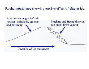
- Resistant bands of rock on valley floor can lead to formation of roche moutonnee
- Roche Moutonnee
- Formed when a glacier flows over a band of resistant rock
- Approximately 20 meters in height, and 10 meters in length
- Strations on upstream side dues to abrasion, and polishing due to rock flour
- Plucking on downstream side
- Corries/Cwm/Cirque
Depositional Landforms
- Moraines
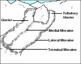
- Lateral Moraine consists largely of frost shattered rocks that have fallen onto the glacier from the valley sides
- Medial Moraine is when a tributary glacier joins the main glacier, and two lateral moraines join up.
- Englacial Moraine is moraine that has been trapped inside the glacier for many years
- Ground Moraine is the rock material that grinds along at the base of the glacier.
- Terminal Moraine is the moraine that marks the furthest the glacier has travelled.
- Recessional Moraine is formed when a glacier retreats, then after a long time starts to move again, gathering moraine as it travels. This moraine is then deposited here and this is known as recessional moraine. It marks a temporary halt in the retreat of the glacier.
- Outwash plain
- Lies beyond the terminal moraine
- A vast expanse of sand and gravel-deposited by braided meltwater rivers from the glacier.
- Till
- The material deposited/dumped on the ground when a glacier retreats.
- Drumlins
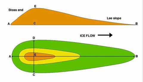
- Upstream side (stoss) is the steep sided
- The downstream side (lee) is the gentle sloping side.
- Egg-shaped hillocks that usually occur in clusters (swarms) in low-lying valley bottoms.
- Consisting of a mixture of boulders and clay (ground moraine)
- Thought to have been a result from the moulding of rock debris on the valley floor by ice moving over it.
- Approximately 10 meters in height, and 40-50 meters in length
- Steep upstream, and long slope downstream
- Moraines
Bilder und Dateien der Mindmap

Informationen
- Beschreibung
- A Levels Geography (Physical Geography-AS) Mindmap am Cold Environments: Glacial Landforms, erstellt von Andrew_Ellinas am 08/05/2014.
- Erstellt von
- Andrew_Ellinas · Mai 2014
- Aktualisiert
- 19 Feb 2016
- Aufrufe
- 51
- Bewertung