¡GoConqr estrena diseño! Cuéntanos qué te parece.

Fichas

LC Short questions; Pictures & Map work
Steven Morgan Geography Leaving Certificate Inglés 27 fichas

LC Short questions; Pictures & Map work

Fichas del conjunto (27)

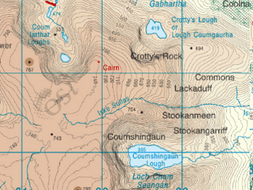
  1. 1—Tarn
    Glacial erosion
    Contour lines packed tight on 3 sides.
    Colour darker on 3 sides.
    4th side contours are spaced.
    Colour is lighter.
    Tarn Glacial erosion Contour lines packed tight on 3 sides. Colour darker on 3 sides. 4th side contours are spaced. Colour is lighter.
  2. 2—Glacial erosion
    Plucking & Abrasion
    Start of Glacier
    Depression with 3 steep sides & 1 open
    With a lake = tarn
    Without lake = Corrie/cirque
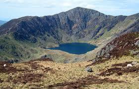
    Glacial erosion Plucking & Abrasion Start of Glacier Depression with 3 steep sides & 1 open With a lake = tarn Without lake = Cor...
  3. 3—Ox Bow Lakes
    Horse shoe shape lake.
    Cut off meander.
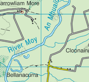
    Ox Bow Lakes Horse shoe shape lake. Cut off meander.
  4. 4—Levee
    Raised banks of earth beside the river channel.
    Spot heights and contour lines show them.
    Old stage of river.
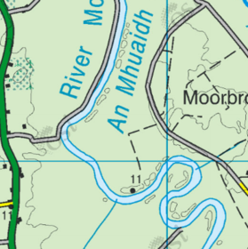
    Levee Raised banks of earth beside the river channel. Spot heights and contour lines show them. Old stage of river.
  5. 5—V shape valley & waterfall
    Found in mountains.
    Brown color
    Tightly packed contour lines
    Contour lines make "V shape"
    Waterfalls may be labelled
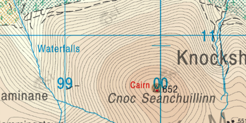
    V shape valley & waterfall Found in mountains. Brown color Tightly packed contour lines Contour lines make "V shape" Waterfalls may b...
  6. 6—Arete
    Glacial erosion
    Thin piece of high ground that separates one corrie/tarn from another.
    Contours packed tightly.
    Brown color.
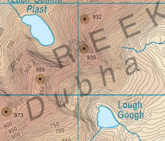
    Arete Glacial erosion Thin piece of high ground that separates one corrie/tarn from another. Contours packed tightly. Brown color.
  7. 7—Ribbon lakes AKA Paternoster lakes
    Glacial erosion
    Plucking & Abrasion
    Found in U shape valley floor (Green).
    Steep sides (Tight contours & Brown colour)
    Lakes connected by a River
    Trellised Drainage pattern
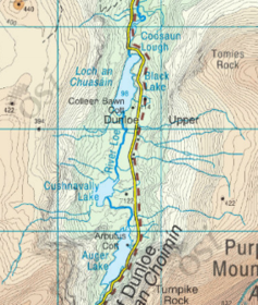
    Ribbon lakes AKA Paternoster lakes Glacial erosion Plucking & Abrasion Found in U shape valley floor (Green). Steep sides (Tight cont...
  8. 8—Drumlins
    Glacial Deposition
    Small hills dotting the land.
    Submerged in Clew Bay
    Spot height will show change in height.
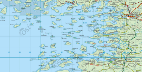
    Drumlins Glacial Deposition Small hills dotting the land. Submerged in Clew Bay Spot height will show change in height.
  9. 9—Flood plain
    River deposition
    Old stage of Rivers
    Green color nearest river channel.
    Widely spaced contour lines.
    Spot heights show height.
    Flat land.
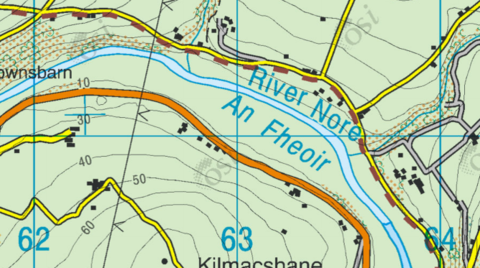
    Flood plain River deposition Old stage of Rivers Green color nearest river channel. Widely spaced contour lines. Spot heights show height...
  10. 10—Sea cliff
    Coastal deposition
    Light/brown color.
    Tightly packed contour lines.
    Spot heights.
    Near sea/ocean
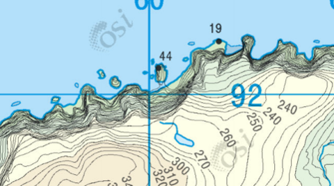
    Sea cliff Coastal deposition Light/brown color. Tightly packed contour lines. Spot heights. Near sea/ocean
  11. 11—Lagoon & Sand Bar
    Bar: Strip of land that covers off a bay.
    Lagoon: Water trapped behind the sand bar.
    Land here is salt marsh as the water dries up.
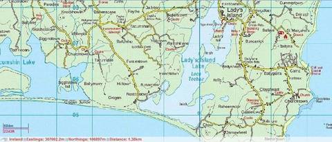
    Lagoon & Sand Bar Bar: Strip of land that covers off a bay. Lagoon: Water trapped behind the sand bar. Land here is salt marsh as the...
  12. 12—A= Sea stack
    B=Sea Arch
    C= Blow hole
    D = Beach/Bay
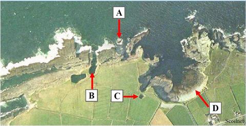
    A= Sea stack B=Sea Arch C= Blow hole D = Beach/Bay
  13. 13—A= Terracettes
    B= Landslide
    C= Mudflow
    D= Rotational slump
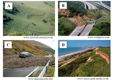
    A= Terracettes B= Landslide C= Mudflow D= Rotational slump
  14. 14—A= Concave slope
    B= Even slope
    C= Dendritic
    D= Drumlins
    E= Cut off meander
    F= Trellised drainage
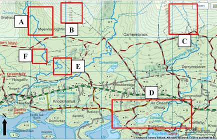
    A= Concave slope B= Even slope C= Dendritic D= Drumlins E= Cut off meander F= Trellised drainage
  15. 15—A= Sandstorm
    B= Open cast mining
    C= Forest Fire
    D= Delta
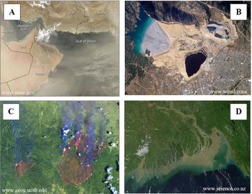
    A= Sandstorm B= Open cast mining C= Forest Fire D= Delta
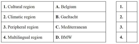
  16. 16—1= B
    2= C
    3= D
    4= A
    1= B 2= C 3= D 4= A
  17. 17—A= Volcanic ash
    B= Forest Fire
    C= Deforestation
    D= Glacier
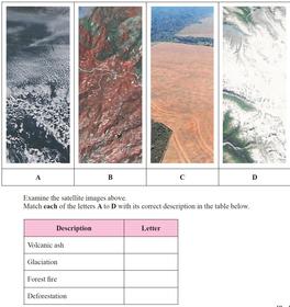
    A= Volcanic ash B= Forest Fire C= Deforestation D= Glacier
  18. 18Groyne Offshore bar Cliff Rock armourA= Offshore bar
    B= Groyne
    C= Cliff
    D= Rock armour
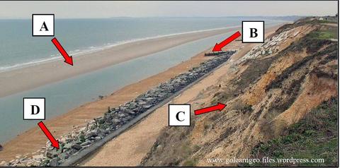
    Groyne Offshore bar Cliff Rock armour
  19. 19—A= Meander
    B= Arete
    C = V shape valley
    D= U shape valley
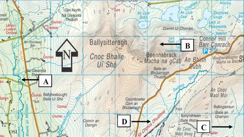
    A= Meander B= Arete C = V shape valley D= U shape valley
  20. 20—A= North American
    B= Eurasian
    C= Africian
    D= South American
    E= Constructive/Divergent
    F= Transform
    G= Destructive/Convergent
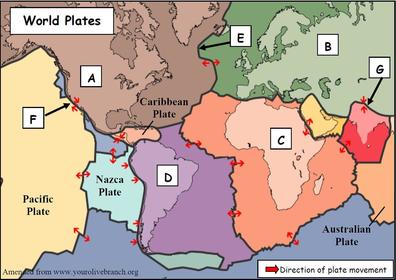
    A= North American B= Eurasian C= Africian D= South American E= Constructive/Divergent F= Transform G= Destructive/Convergent
  21. 21—A= Radial
    B= Trellised
    C= Denderitic
    D= Deranged
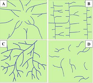
    A= Radial B= Trellised C= Denderitic D= Deranged
  22. 22—A= Tremors
    B= Fault line
    C= Focus
    D= Epicenter
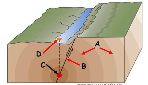
    A= Tremors B= Fault line C= Focus D= Epicenter
  23. 23—A= Tarn
    B= Truncated spur
    C= Arete
    D= Hanging Valley
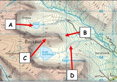
    A= Tarn B= Truncated spur C= Arete D= Hanging Valley
  24. 24—A= Attrition
    B= Terracetes
    C= Blowhole
    D= Scree
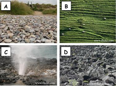
    A= Attrition B= Terracetes C= Blowhole D= Scree
  25. 25—A= Later moraine
    B= Arete
    C= Pyramidal peak
    D= Corrie
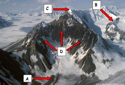
    A= Later moraine B= Arete C= Pyramidal peak D= Corrie
  26. 26—A= Lava
    B= Ash cloud/gas
    C= Crater
    D= Pyroclastic material
    E= Magma Reserve
    F= Secondary vent
    G= Vent
    H= Parasitic cone
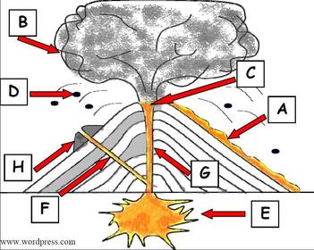
    A= Lava B= Ash cloud/gas C= Crater D= Pyroclastic material E= Magma Reserve F= Secondary vent G= Vent H= Parasitic cone
  27. 27—Central plain = C
    Wallonia = D
    Mediterranean = A
    Berlin = B
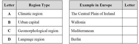
    Central plain = C Wallonia = D Mediterranean = A Berlin = B

Información

Descripción
LC Short questions; Pictures & Map work
Creado por
Steven Morgan
Visitas
377
Valoración

Escríbenos

¿Sobre qué es tu mensaje?

¿Qué te parece el nuevo diseño?

¿Te gusta?