
Mapa mental
River Tees drainage basin: upper, middle and lower course
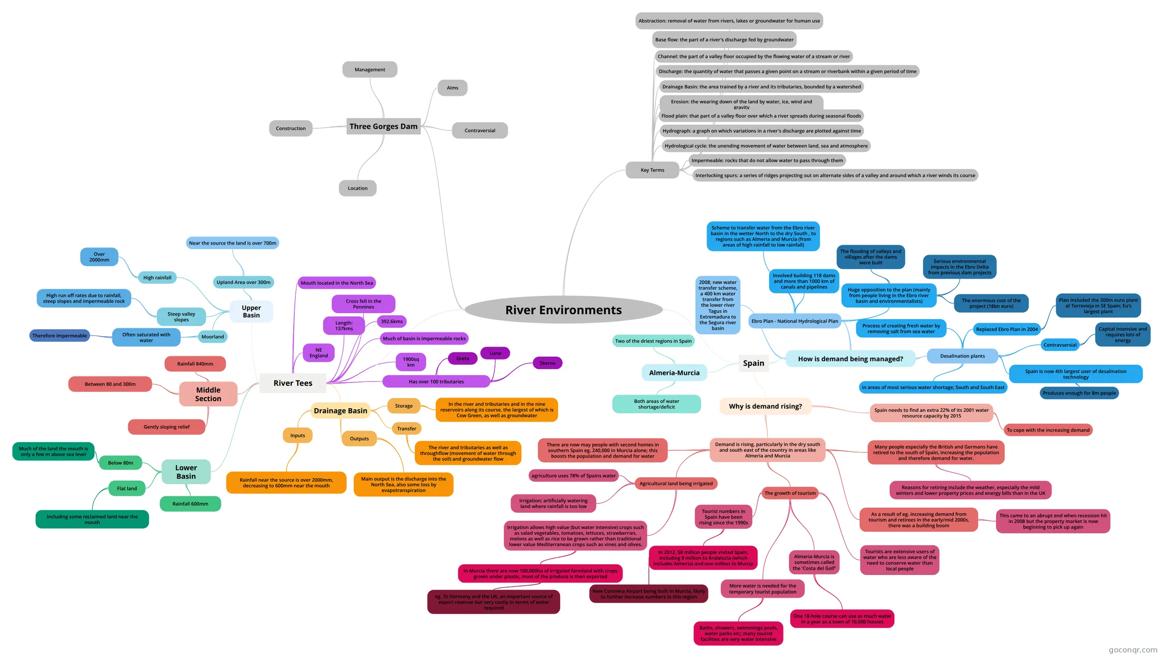
Mind map: River environments
Contenido del mapa
River Environments
River Tees
- NE England
- 1900sq km
- 392.6kms
- Cross fell in the Pennines
- Length: 137kms
- Mouth located in the North Sea
- Has over 100 tributaries
- Greta
- Luna
- Skerne
- Much of basin is impermeable rocks
- Upper Basin
- Upland Area over 300m
- Near the source the land is over 700m
- Moorland
- Often saturated with water
- Therefore impermeable
- Often saturated with water
- High rainfall
- Over 2000mm
- Steep valley slopes
- High run off rates due to rainfall, steep slopes and impermeable rock
- Upland Area over 300m
- Middle Section
- Between 80 and 300m
- Rainfall 840mm
- Gently sloping relief
- Lower Basin
- Below 80m
- Much of the land the mouth is only a few m above sea level
- Flat land
- Including some reclaimed land near the mouth
- Rainfall 600mm
- Below 80m
- Drainage Basin
- Inputs
- Rainfall near the source is over 2000mm, decreasing to 600mm near the mouth
- Storage
- In the river and tributaries and in the nine reservoirs along its course, the largest of which is Cow Green, as well as groundwater
- Transfer
- The river and tributaries as well as throughflow (movement of water through the soil) and groundwater flow
- Outputs
- Main output is the discharge into the North Sea, also some loss by evapotranspiration
- Inputs
Spain
- Almeria-Murcia
- Two of the driest regions in Spain
- Both areas of water shortage/deficit
- Why is demand rising?
- Spain needs to find an extra 22% of its 2001 water resource capacity by 2015
- To cope with the increasing demand
- Demand is rising, particularly in the dry south and south east of the country in areas like Almeria and Murcia
- There are now may people with second homes in southern Spain eg. 240,000 in Murcia alone; this boosts the population and demand for water
- Agricultural land being irrigated
- agriculture uses 78% of Spains water
- Irrigation; artificially watering land where rainfall is too low
- Irrigation allows high value (but water intensive) crops such as salad vegetables, tomatoes, lettuces, strawberries, melons as well as rice to be grown rather than traditional lower value Mediterranean crops such as vines and olives.
- In Murcia there are now 100,000ha of irrigated farmland with crops grown under plastic, most of the produce is then exported
- eg. To Germany and the UK, an important source of export revenue but very costly in terms of water required
- In Murcia there are now 100,000ha of irrigated farmland with crops grown under plastic, most of the produce is then exported
- The growth of tourism
- Tourist numbers in Spain have been rising since the 1990s
- In 2012, 58 million people visited Spain, including 8 million to Andalucia (which includes Almeria) and one million to Murcia
- New Corovera Airport being built in Murcia, likely to further increase numbers in this region
- In 2012, 58 million people visited Spain, including 8 million to Andalucia (which includes Almeria) and one million to Murcia
- Tourists are extensive users of water who are less aware of the need to conserve water than local people
- More water is needed for the temporary tourist population
- Baths, showers, swimmings pools, water parks etc; many tourist facilities are very water intensive
- Almeria-Murcia is sometimes called the 'Costa del Golf'
- One 18-hole course can use as much water in a year as a town of 10,000 houses
- Tourist numbers in Spain have been rising since the 1990s
- As a result of eg. increasing demand from tourism and retirees in the early/mid 2000s, there was a building boom
- This came to an abrupt end when recession hit in 2008 but the property market is now beginning to pick up again
- Many people especially the British and Germans have retired to the south of Spain, increasing the population and therefore demand for water.
- Reasons for retiring include the weather, especially the mild winters and lower property prices and energy bills than in the UK
- Spain needs to find an extra 22% of its 2001 water resource capacity by 2015
- How is demand being managed?
- Ebro Plan - National Hydrological Plan
- Scheme to transfer water from the Ebro river basin in the wetter North to the dry South , to regions such as Almeria and Murcia (from areas of high rainfall to low rainfall)
- Involved building 118 dams and more than 1000 km of canals and pipelines
- Huge opposition to the plan (mainly from people living in the Ebro river basin and environmentalists)
- Serious environmental impacts in the Ebro Delta from previous dam projects
- The enormous cost of the project (18bn euro)
- The flooding of valleys and villages after the dams were built
- DesalInation plants
- Replaced Ebro Plan in 2004
- Plan included the 300m euro plant at Torrevieja in SE Spain; Eu's largest plant
- in areas of most serious water shortage; South and South East
- Process of creating fresh water by removing salt from sea water
- Spain is now 4th largest user of desalination technology
- Produces enough for 8m people
- Contravsersial
- Capital intensive and requires lots of energy
- Replaced Ebro Plan in 2004
- 2008; new water transfer scheme, a 400 km water transfer from the lower river Tagus in Extremadura to the Segura river basin
- Ebro Plan - National Hydrological Plan
- Almeria-Murcia
Three Gorges Dam
- Location
- Construction
- Management
- Aims
- Contraversial
Key Terms
- Abstraction: removal of water from rivers, lakes or groundwater for human use
- Base flow: the part of a river's discharge fed by groundwater
- Channel: the part of a valley floor occupied by the flowing water of a stream or river
- Discharge: the quantity of water that passes a given point on a stream or riverbank within a given period of time
- Drainage Basin: the area trained by a river and its tributaries, bounded by a watershed
- Erosion: the wearing down of the land by water, ice, wind and gravity
- Flood plain: that part of a valley floor over which a river spreads during seasonal floods
- Hydrograph: a graph on which variations in a river's discharge are plotted against time
- Hydrological cycle: the unending movement of water between land, sea and atmosphere
- Impermeable: rocks that do not allow water to pass through them
- Interlocking spurs: a series of ridges projecting out on alternate sides of a valley and around which a river winds its course
Información
- Descripción
- Mapa Mental sobre Sin título, creado por georgiabron el 13/04/2015.
- Creado por
- georgiabron
- Visitas
- 0
- Valoración